
Eskimo Joe
-
Posts
24,951 -
Joined
-
Last visited
Content Type
Profiles
Blogs
Forums
American Weather
Media Demo
Store
Gallery
Everything posted by Eskimo Joe
-
Agreed. Standard caveat is that folks should always have low expectations going into this and be happy with what we get. To see this in a La Nina pattern is pretty amazing.
-
12z EPS sets up decent western ridge and maintains the stout -NAO. Cross polar flow tries to show up around Jan 16th. This is a signal that has existed for the past 24 hours:
-
*ahem* I'll have you know I'm on the southern end of Jackpotville™.
-
EPS sets up cross polar flow and a western ridge towards the end of the run. To have it show up on the ensembles and not some rogue OP run is important and boost confidence in this solution:
-
meso models starting to really ping an advisory level snow event Sunday for I-70 north and US15 west.
-
-
12z GFS/CMC definitely trended in the right direction.
-
Trace ZR Reisterstown 32/29.
-
Yea Eric Webb isn't a big snow weenie. If he starts getting interested then so do I.
-
How long until Ji complains?
-
It's now 2021 for those living in UTC time. 33/30 with light fireworks in Reisterstown.
-
Hell, if we manage like back-to-back-to-back 5" - 10" event in the course of like 2 weeks that would be 100%+ of climo for everyone.
-
I'm not expecting consistent double digit snowfalls, but this should at least get almost everyone to climo if the pattern holds. Hell, after the past two winters climo will feel great.
-
The signal from mid January on is hawt. I haven't been this excited since 2010.
-
Yea the evolution really is nice.
-
^there's definitely been a trend to nudge everything over to NA instead of the other side of the hemisphere. Good to see.
-
-
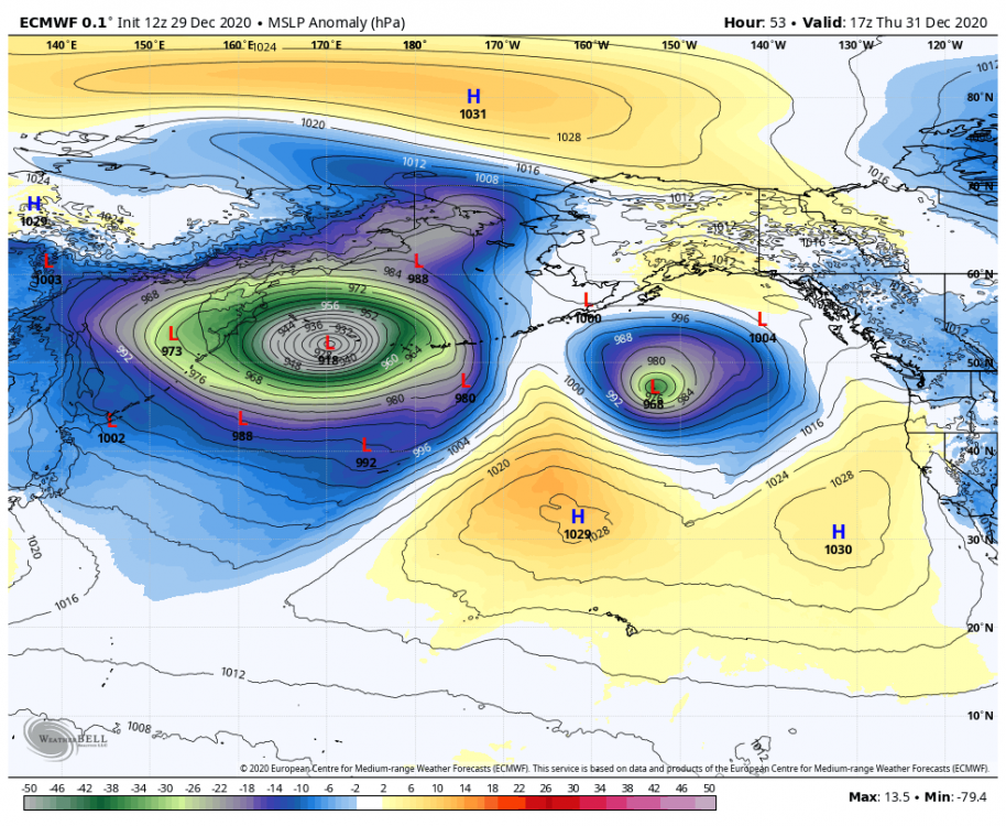
It's a damn shame we can rid ourselves of this low in the Gulf of Alaska. Without it, that Aleutian Low would be pumping one hell of a west coast ridge for us.
-
Key difference with Euro weeklies now is that it's NW flow across all of Canada which rapidly builds snow cover and solidifies a cP airmass for us. If this holds, it significantly increases the likelihood of below normal temps and at least embedded clippers.
-

Central PA - Winter 2020/2021
Eskimo Joe replied to MAG5035's topic in Upstate New York/Pennsylvania
Self quarantined for 2 weeks and a negative COVID test allowed us to see the in laws in Mt. Joy. We were rewarded with a dusting of snow last night. -
Central PA - Winter 2020/2021
Eskimo Joe replied to MAG5035's topic in Upstate New York/Pennsylvania
18z GFS/GEFS showing some Christmas love for all of CTPs CWA. Solid advisory level event. -
The updated NWS radar is terrible
Eskimo Joe replied to Heisy's topic in Weather Forecasting and Discussion
This interface is very slow and seems to rely on third party data for the underlying base map. Given the antecedent challenges with NWS IT infrastructure their move to this product was, IMO, short sighted. I prefer the old radar because it was faster to load, easier to interpret, and still worked when you had limited data connection. I encourage anyone with a strong opinion, positive or negative, to email: [email protected] -
Central PA - Winter 2020/2021
Eskimo Joe replied to MAG5035's topic in Upstate New York/Pennsylvania
-
Central PA - Winter 2020/2021
Eskimo Joe replied to MAG5035's topic in Upstate New York/Pennsylvania
Updates watch text from CTP: -
Central PA - Winter 2020/2021
Eskimo Joe replied to MAG5035's topic in Upstate New York/Pennsylvania
NAM seems to be incredibly aggressive with shoving plain rain up into even THV/LNS. Probably going to be some mixing issues along Mason/Dixon but I can't see how that verifies. It's the warmest of all solutions by a long shot.