

Eskimo Joe
-
Posts
24,697 -
Joined
-
Last visited
Content Type
Profiles
Blogs
Forums
American Weather
Media Demo
Store
Gallery
Everything posted by Eskimo Joe
-
I'd always take temps and elevation.
-
Nice
-

Feb Long Range Discussion (Day 3 and beyond) - MERGED
Eskimo Joe replied to WinterWxLuvr's topic in Mid Atlantic
-
Feb Long Range Discussion (Day 3 and beyond) - MERGED
Eskimo Joe replied to WinterWxLuvr's topic in Mid Atlantic
The Sperry Piltz Ice Accretion Index leverages wind and ice accretion to measure impacts. I'm going to cut the forecasted amount in half, which would mean an Ice Damage Index of at least a 1. However, a year or two ago we had this ice event in upper Montgomery County where we got between 0.3" and 0.5" ice with almost no wind and it was impressive. A lot of trees snapping in two, event the hardwoods, which caused big problems to the power grid. Some places were out for 3 days and that was for the Allegheny Power service area which does a good job at tree trimming. Something like what's being advertised there would be probably a 2 or 3.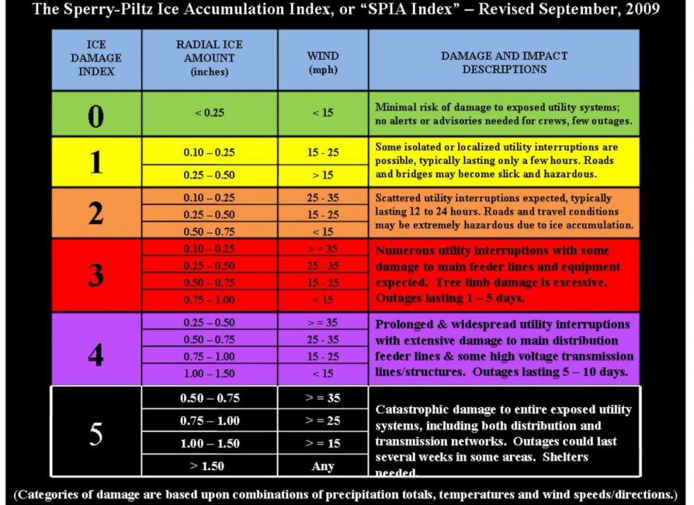
-
-
Feb Long Range Discussion (Day 3 and beyond) - MERGED
Eskimo Joe replied to WinterWxLuvr's topic in Mid Atlantic
Even if you cut that by 50% it's substantial. -
Euro gets snow in prior to sunrise. Once it starts, not let up...good to see.
-
I actually think you're better positioned than I am for this event.
-
Unpopular opinion: The winners in this event are those who get under this band of good snow. Inside that band, you jackpot and push 5" - 9"...outside of that band it's going to be a more general 2"-4" event.
-
Yes. HREF always seems to underdo snow. The fact that it's painting 4-6" is impressive, standard regional disclaimer about microclimates apply.
-
Feb Long Range Discussion (Day 3 and beyond) - MERGED
Eskimo Joe replied to WinterWxLuvr's topic in Mid Atlantic
.gif.b9477c3feaa41ae4b8de1b06aec2f978.gif)

-
The canadian mimics the NAMs intense 700mb frontogenetic forcing all the way up into Long Island.
-
GFS would be a solid advisory level event for everyone, all the better that it's on a weekend so we can all enjoy it!
-
NAM and RGEM would imply low end warning criteria snow for everyone east of I-81.
-
.gif.9b5f137e1f507a7ee744d7b3a53568f0.gif)
-
Compare that to Maine, where they had a 56:1 event last night.
-
-
Feb Long Range Discussion (Day 3 and beyond) - MERGED
Eskimo Joe replied to WinterWxLuvr's topic in Mid Atlantic
Taking a look at the 500mb maps of the 18z GFS, we see sub 500dm heights settle over Pennsylvania just in time for Valentine's Day. Yes please. -
Feb Long Range Discussion (Day 3 and beyond) - MERGED
Eskimo Joe replied to WinterWxLuvr's topic in Mid Atlantic
HM barking -
Feb Long Range Discussion (Day 3 and beyond) - MERGED
Eskimo Joe replied to WinterWxLuvr's topic in Mid Atlantic
I believe @usedtobe or @Ian had a good research article about how cold pooling over Alaska during the depths of winter could mean a big east coast ridge was developing. Not sure who authored it, but I remember reading and the science was pretty sound. -
Feb Long Range Discussion (Day 3 and beyond) - MERGED
Eskimo Joe replied to WinterWxLuvr's topic in Mid Atlantic
-
Jan 31st - 33rd Storm Obs and Disco like it's 1979
Eskimo Joe replied to Bob Chill's topic in Mid Atlantic
More TV Snow™ -
Jan 31st - 33rd Storm Obs and Disco like it's 1979
Eskimo Joe replied to Bob Chill's topic in Mid Atlantic
The warm layer and mix line will almost always work more NW that what's forecast. It's one of those tested weather rules in these parts. -
Jan 31st - 33rd Storm Obs and Disco like it's 1979
Eskimo Joe replied to Bob Chill's topic in Mid Atlantic
What a loop: -
Jan 31st - 33rd Storm Obs and Disco like it's 1979
Eskimo Joe replied to Bob Chill's topic in Mid Atlantic
Had the WAA snow been as strong as advertised, this storm would have been far less stressful for just about everyone. Even the crew along Aberdeen to Sparrows Point to Annapolis. You need good rates to get it down to the bay.


