

Eskimo Joe
-
Posts
24,724 -
Joined
-
Last visited
Content Type
Profiles
Blogs
Forums
American Weather
Media Demo
Store
Gallery
Everything posted by Eskimo Joe
-
Visible satellite shows obvious clearing and our afternoon severe potential in central OH. This could be a sneaky day.
-

2023 Mid-Atlantic Severe Wx Thread (General Discussion)
Eskimo Joe replied to Kmlwx's topic in Mid Atlantic
High Wind Watch now a warning. Other areas a Wind Advisory. -
High Wind Watch expanded east into the Baltimore/DC area.
-
No, early 2000s. Somewhere in the 2003 - 2005 timeframe. Can't find it off the top of my head in the SPC event archive.
-
Biggest convective gust I witnessed was in Philly as a kid. We got a severe t'storm warning from a low topped line of convection. Only had 1 rumble of thunder, but got a M63 mph wind gust on my home weather station. We had a lot of large trees down and a neighborhood church got damage to it's steeple roof.
-
Yes. Embrace the suck.
-
^Nice
-
Yea. 06z NAM has a nice 55-60kt streak at 925 mb moving smack dab over the DC metro region at 00z Sunday.
-
Same with the HRRR
-
"My app says you're an idiot."
-
Get ready for 57 and a driving rain on Christmas next winter.
-
2023 Mid-Atlantic Severe Wx Thread (General Discussion)
Eskimo Joe replied to Kmlwx's topic in Mid Atlantic
New WPC graphic for heavy rainfall. Kind of similar to SPC.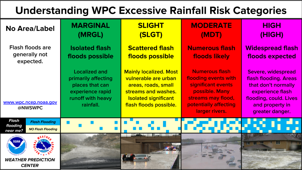
- 2,785 replies
-
- 6
-

-
- severe
- thunderstorms
- (and 3 more)
-
Woke up at 6am it was 32 degrees. Left at 7am and the temp already was up to 36. Goes to show you how strong the sun angle is this time of year.
-
Low of 32 in Reisterstown with light frost on car and deck.
-
Today turned out surprisingly nice. Not a lot of wind and deep sunshine.
-
SVR #002 of the year:
-
The only two spot that I think you could see locally, due to limited light pollution, are Blackwater Wildlife Refuge or Deal Island State Wildlife Management Area.
-
The cell NW of Bath, WV bears some watching. It's got an uptick in CG and it's riding NW flow on a warm front.
-
Good lord. We do heat and wind well here no doubt.
-
DC getting decent SW wind. If there was more sun today, they probably would've touched 80.
-
EDIT: NAM/HRRR insistent that we break out well into the warm section this afternoon and get well into the 70s.
-
I think we end up with a decent afternoon.
-
The 12z GFS developed a small surface reflection Friday night over West Virginia that scoots northeast to NYC. If that happens, there might be enough SW flow to erode the wedge and salvage Saturday. But make no mistake, we are entering backdoor cold front season.
-
^Old E/E rule right there. Expect da wedgie.


