AlexD1990
-
Posts
655 -
Joined
-
Last visited
Content Type
Profiles
Blogs
Forums
American Weather
Media Demo
Store
Gallery
Posts posted by AlexD1990
-
-
^February would be rockin LOL.
Tangentially related, but Dan Satterfield(Local on-air Met) posted on his social media today a very(for him) bold call/higher than normal possibility of a possibly snowy winter, and even went so far as to invoke 09-10..
-
 2
2
-
 1
1
-
-
77December isn’t a winter month anymore. It will probably be partly cloudy and 57.
Sent from my SM-F711U using Tapatalk
-
 3
3
-
-
Local Mets mentioning the remnants loop back and hit as another nor easter next weekend
Sent from my SM-F711U using Tapatalk -
Wind is howling in bursts in Angola, Delaware (just inland of dewey Beach on rehoboth bay)
We bought a trailer this spring and how anyone could feel safe in anything stronger than this is amazing to me, there's been several gusts where I have wondered if it's going to flip over. Not the best nights sleep. ...
Sent from my SM-F711U using Tapatalk-
 2
2
-
-
3 minutes ago, CAPE said:
They've been playing that at my work
-
 3
3
-
-
18 minutes ago, CAPE said:
Probably just a lot of rain here. Might see some gusts to 30 or so.
Found this interesting little nugget buried in the very extensive AFD from Mount Holly this morning:
Some of the local TV mets were mentioning this on social media yesterday. Definitely not a hazard I was initially prepared to be dealing with...
-
 2
2
-
-
Sandy, Irene, and blizzard of 2016, if I read the info graphic correctlyWhen were those records set? Isabel? Sandy? Or maybe Ash Wednesday if the records go back that far?
Sent from my SM-F711U using Tapatalk
-
 1
1
-
-
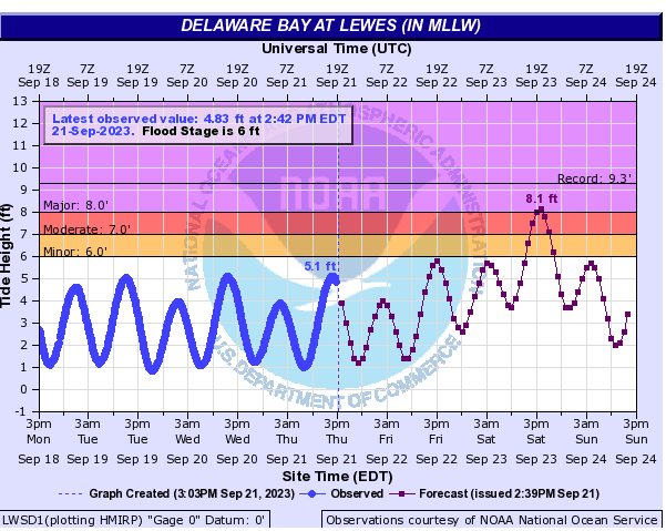
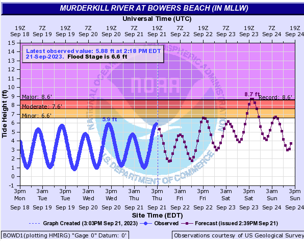
Record or near-record flooding now forecast along the Delaware Bay:


-
 3
3
-
-
WOW. Definitely making up for lost time on that advisory!
-
1 minute ago, WxWatcher007 said:
I’ve seen this happen a few times recently with homebrew systems. Kind of surprised the NHC wasn’t higher given the cross guidance signal on the models, particularly in the last 24 hours.
Agreed. From the standpoint of the general public(if they're even paying attention), it would seem to be confusing..
-
 1
1
-
-
I can't remember the last time they moved so quickly through the stages. We went from a 40% orange to advisories on a PTC in what, an hour??
-
Just now, yoda said:
Going to have to do some checking... and I know it's very unlikely, but when was the last time LWX issued tropical products aka HLS?
Maybe Isaias or Elsa?
-
How much credence can we lend to the NAM, though? Still eyebrow-raising, nonetheless..
-
Good to remember for winter...What a complete cave by the Euro.
Sent from my SM-F711U using Tapatalk
-
 2
2
-
-
The main thread is unreadable
Sent from my SM-F711U using Tapatalk-
 1
1
-
-
This thing has now caused several thousand deaths in Lybia
Sent from my SM-F711U using Tapatalk-
 1
1
-
 1
1
-
-
Now a tornado warning on the eastern shore
Sent from my SM-F711U using Tapatalk -
New advisory out:
Hurricane Lee Advisory Number 9
NWS National Hurricane Center Miami FL AL132023 1100 AM AST Thu Sep 07 2023
...LEE RAPIDLY STRENGTHENING... ...LARGE SWELLS LIKELY TO REACH THE LESSER ANTILLES, THE VIRGIN ISLANDS, AND PUERTO RICO THIS WEEKEND...
SUMMARY OF 1100 AM AST...1500 UTC...INFORMATION ----------------------------------------------- LOCATION...16.4N 50.0W ABOUT 870 MI...1405 KM E OF THE NORTHERN LEEWARD ISLANDS
MAXIMUM SUSTAINED WINDS...105 MPH...165 KM/H PRESENT MOVEMENT...WNW OR 295 DEGREES AT 15 MPH...24 KM/H MINIMUM CENTRAL PRESSURE...983 MB...29.03 INCHES
WATCHES AND WARNINGS -------------------- There are no coastal watches or warnings in effect. Interests in the northern Leeward Islands should monitor the progress of Lee.
DISCUSSION AND OUTLOOK ---------------------- At 1100 AM AST (1500 UTC), the center of Hurricane Lee was located near latitude 16.4 North, longitude 50.0 West. Lee is moving toward the west-northwest near 15 mph (24 km/h), and this motion is expected to continue through Friday. A slower motion toward the west-northwest is forecast over the weekend. On the forecast track, the core of Lee will move north of the northern Leeward islands during the next few days. Maximum sustained have quickly increased to near 105 mph (165 km/h) with higher gusts. Rapid intensification is expected today and tonight. Lee will likely become a major hurricane later today. Lee is forecast to remain a very strong major hurricane through the weekend Hurricane-force winds extend outward up to 25 miles (35 km) from the center and tropical-storm-force winds extend outward up to 90 miles (150 km).
Sent from my SM-F711U using Tapatalk-
 1
1
-
-
Maybe even rotation on the cell near Nokesville?Activity running from Calverton, VA up to Manassas is growing nicely.
Sent from my SM-F711U using Tapatalk
-
Multiple tornado warnings in SoMd
Sent from my SM-F711U using Tapatalk -
Looks like a small hook developing near TaneytownClassic supercell structure on that storm cruising along the M/D line
Sent from my SM-F711U using Tapatalk
-
Now a tornado warning
Sent from my SM-F711U using Tapatalk -
Tornado watch just to the south
Sent from my SM-F711U using Tapatalk -
Got dark as night here before it hit. Torrential rain and some gusts probably in the 40s
Sent from my SM-F711U using Tapatalk-
 1
1
-

October Long Range
in Mid Atlantic
Posted
That was god tier posting.