

AlexD1990
-
Posts
980 -
Joined
-
Last visited
Content Type
Profiles
Blogs
Forums
American Weather
Media Demo
Store
Gallery
Posts posted by AlexD1990
-
-
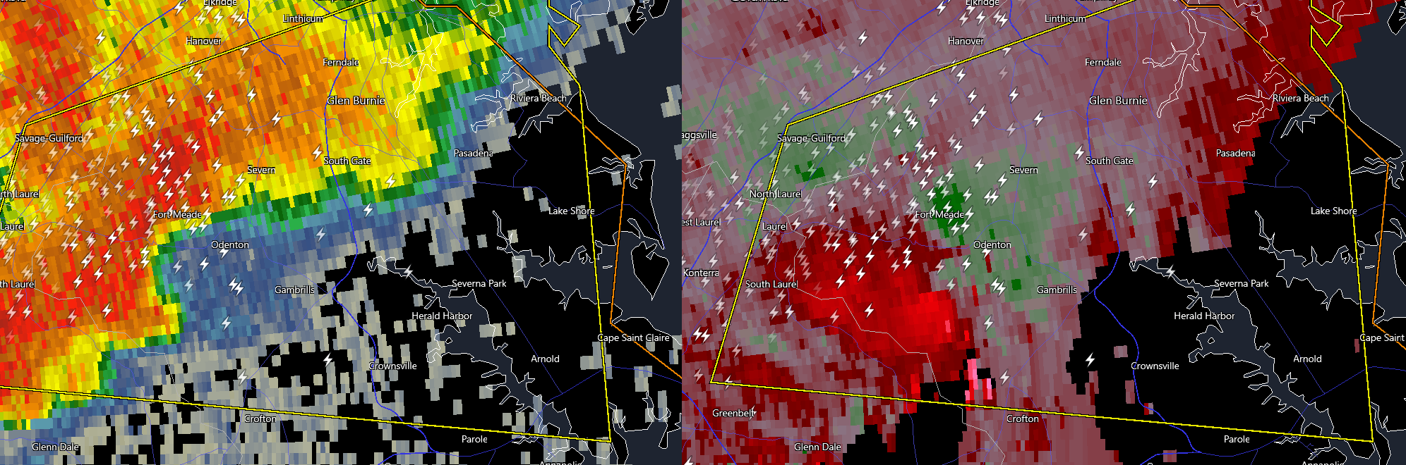
any posters in the area that can provide ground truth?
-
1 minute ago, caviman2201 said:
That really should be TOR warned IMO...
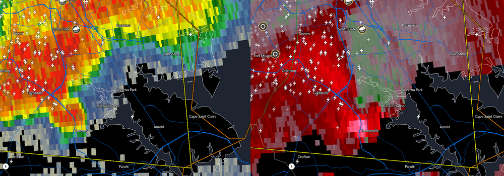
Came here to say this, the appendage is notable even on reflectivity
-
13 minutes ago, caviman2201 said:
That Northern AACo storm looking kinda spicy...

that rotation has tightened up, you can even see it on BWI terminal radar
-
 1
1
-
-
Rotation north of Fredericksburg?
Sent from my Pixel 9 Pro XL using Tapatalk -
Maybe a teensy bit of CC drop with the ft Washington cell? Could be radar hallucinating
Sent from my Pixel 9 Pro XL using Tapatalk -
Seven nowSix active tornado warnings in the region
Sent from my Pixel 9 Pro XL using Tapatalk
-
 1
1
-
-
They reissued the severe thunderstorm watch for the Northern part of the Delmarva. Lol why not just have left the original watch going
Sent from my Pixel 9 Pro XL using Tapatalk-
2
-
-
Watch issued for your guys
-
8 minutes ago, CAPE said:
Go chase it.
")
Looks like the cell just to the NE of that one is pretty close to your neck of the woods.
I'm just off rt24 my house is between them
-
1
-
-
8 minutes ago, CAPE said:
Go chase it.
Looks like the cell just to the NE of that one is pretty close to your neck of the woods.
I'm at work in Rehoboth

-
Just now, CAPE said:
Looks more impressive now.
its also shifted right. heading for millsboro

-
TOR for sussex county, DE. this storm went kidney shaped as soon as it fired
-
Just now, SnowenOutThere said:
Oops, basically the same state imo
them's fighting words

-
Just now, toolsheds said:
I pulled up radarscope when I saw that note and there was a strange correlation coefficient readout between denton and bridgeville on 404. Maybe this is what he saw?
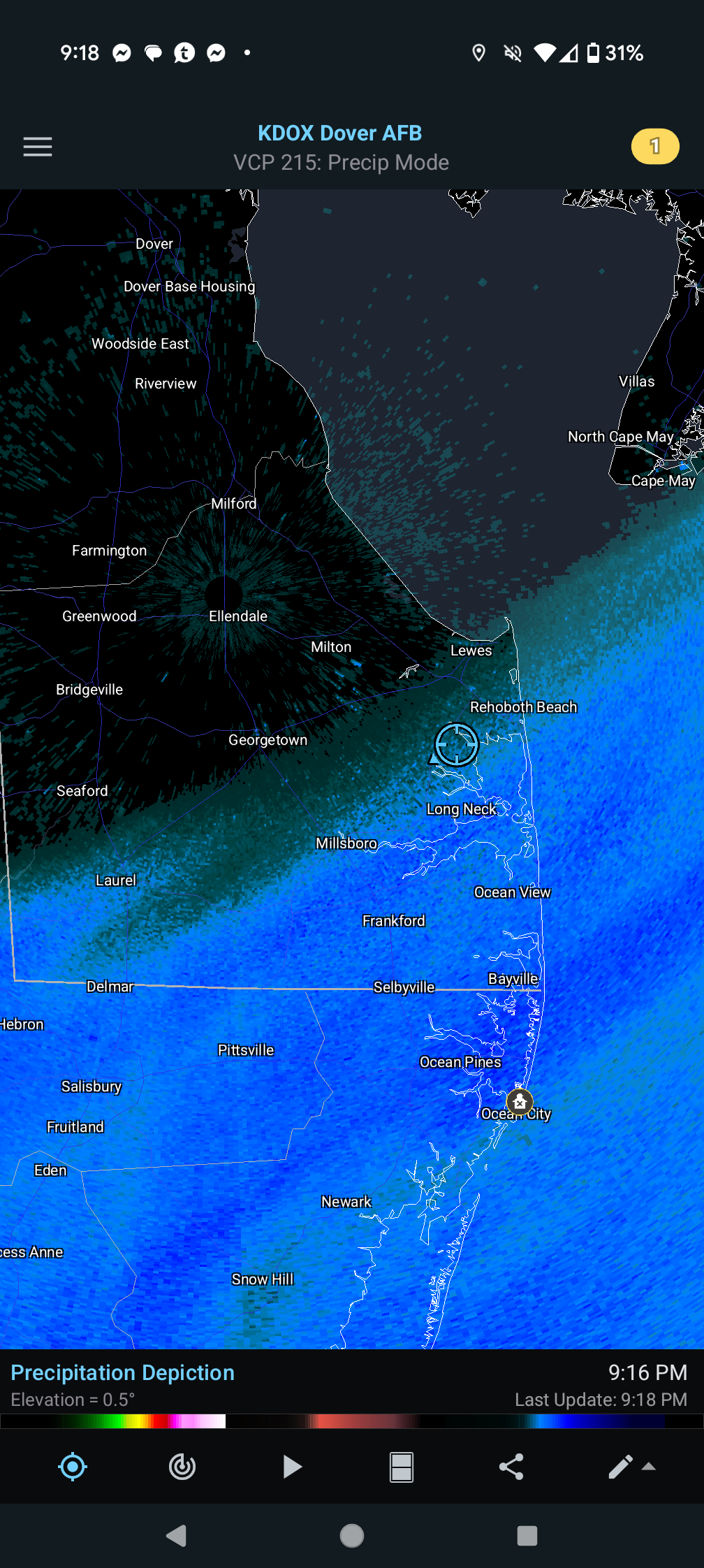
perhaps. Also of note, KDOX radar appears to be back online, not a moment too soon.
-
2
-
-
22 minutes ago, SnowenOutThere said:
Tornado debris ball signature way out in Deleware
Did you mean New Jersey? no TOR's issued for Delaware yet
-
1
-
-
Storm near Millville has a halfway decent couplet on it with a TOR.
-
1
-
-
TOR near Short Pump
-
1 hour ago, Scarlet Pimpernel said:
Mimosas...served by Jesus! But I shouldn't bring religion in here (unless snow counts as a religion!).

I think you know the answer to that.
-
 2
2
-
-
On the outside looking in. Only have about an inch IMBY. Powdered sugar snow, swept instead of shovelled

-
2
-
-
If only the edge set up 15 miles to the north


-
15 minutes ago, csnavywx said:
Insanely sharp gradient here. 1.5" on north side of KNHK, 2.0 on the station itself and nearly 3" on the south side of the base and at my house. Bet Pt. Lookout to SBY ends up somewhere over 5"
The gradient is crazy. Still lightly snowing at my house with nothing in Rehoboth, maybe 4 miles as the crow flies.
-
46 minutes ago, csnavywx said:
Can only imagine what this sucker could've produced with a full phase.
Ah well -- we've got the next 3-4 weeks and hopefully a weak +ENSO/-AO year to play with next year.
It would have been nice, but like you said, maybe just maybe we can cash in one more time. It's definitely been a nice winter in these parts.
-
Shifted south, just flurries left in Rehoboth. Eyeballing about an inch.
-
Better pic lol
-
10
-

2025 Severe Weather General Discussion
in Mid Atlantic
Posted
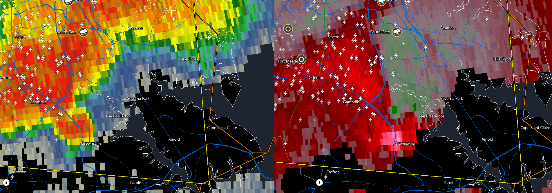
Justin Berk posted a video of a funnel cloud near Odenton. Definitely looks like it tried to form one.