

so_whats_happening
-
Posts
1,350 -
Joined
-
Last visited
Content Type
Profiles
Blogs
Forums
American Weather
Media Demo
Store
Gallery
Posts posted by so_whats_happening
-
-
Just now, so_whats_happening said:
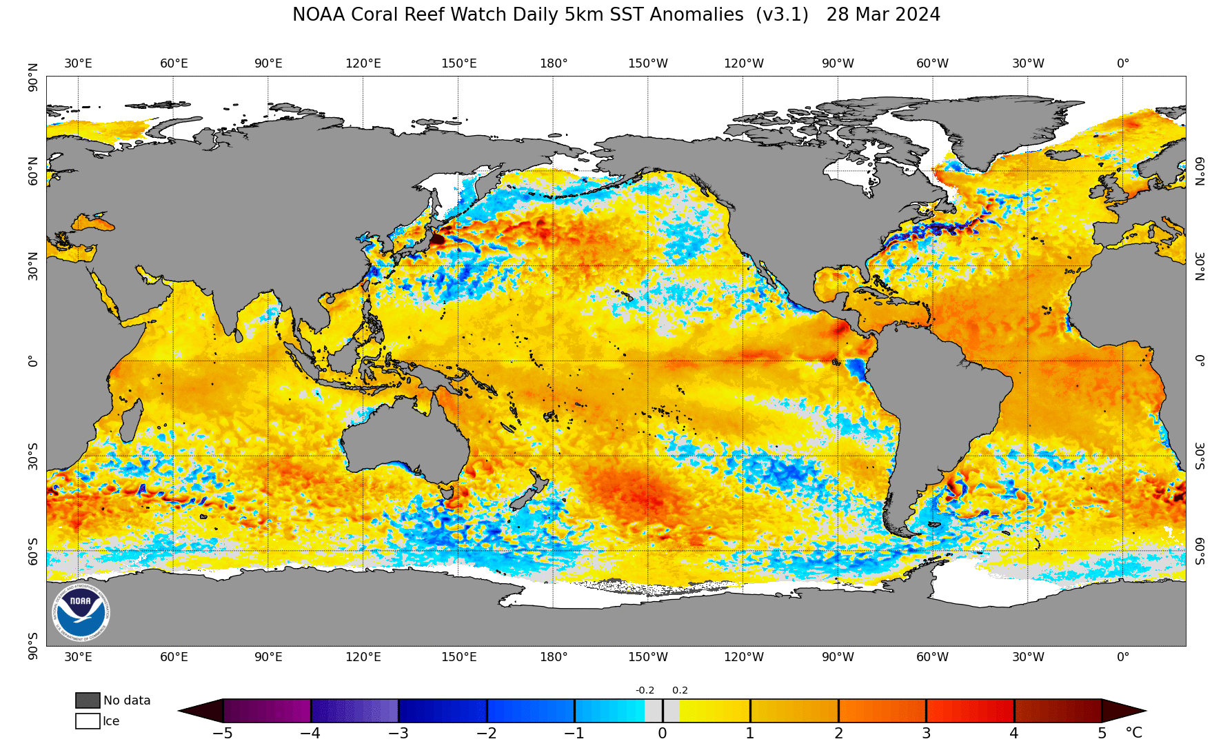
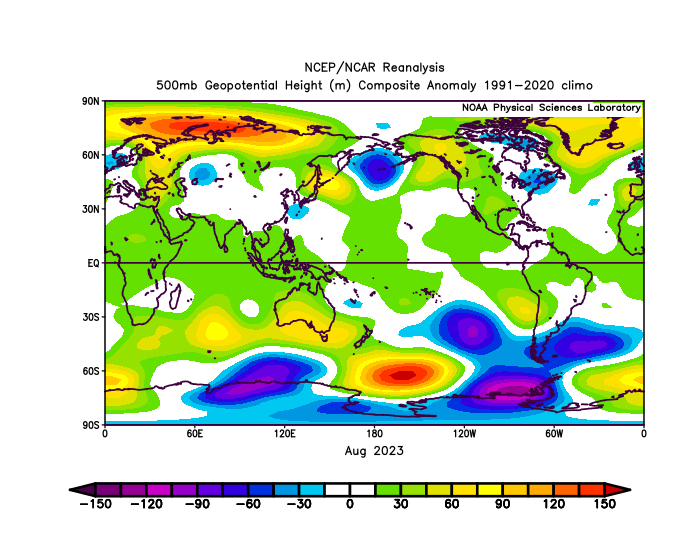
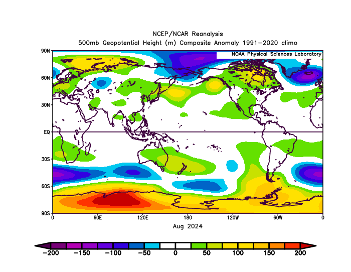
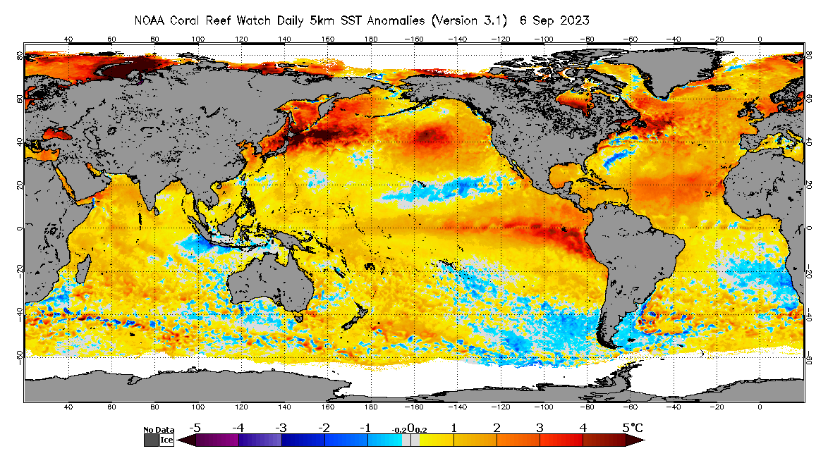
I wanted to add the end of summer comparison to last year I have in stock. This new one starts on 9/6 to 12/4. The warm anomalies are east of where they were at the start of September last year so we are seeing a shift occur not as intense around Japan but still very warm in many regions around Japan.
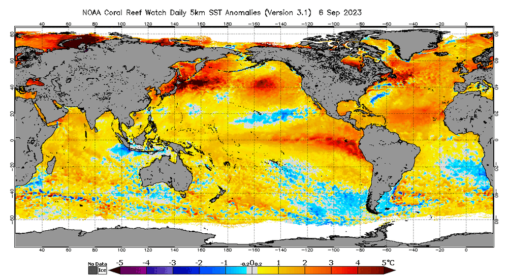
It was around the end of September when we saw the 500mb pattern take hold and SST configurations sort of lock in. It will be interesting to see what the next 3 weeks looks like.
-
31 minutes ago, so_whats_happening said:
I wanted to add the end of summer comparison to last year I have in stock. This new one starts on 9/6 to 12/4. The warm anomalies are east of where they were at the start of September last year so we are seeing a shift occur not as intense around Japan but still very warm in many regions around Japan.
-
 1
1
-
 1
1
-
-
3 minutes ago, GaWx said:
What do you know about the cause of that insanely warm N Pacific area? It wouldn’t surprise me if some anomalies in that +5+ area are +8+!
I’ve been reading about underwater seismic activity possibly being a cause. What do you know about that?It is a possibility for maybe having the extreme anomaly presence, as far we know the NW Atlantic does not have major seismic activity. So when the Atlantic and Pacific have mirror looks it makes me have pause that could be the situation. The NW Atlantic has a more shallow depth region so that may play a role in having a mirror look to the Pacific without the Seismic influence.
Honestly though it is a mystery as of now why the pattern is pushing extremes and what exactly it will take to rid us of this pattern. The tropical activity early on put dents into it here and there but has since smoothed out the area just NE of Japan I am curious about the storm track this year and how much change will occur over winter.
-
1
-
-
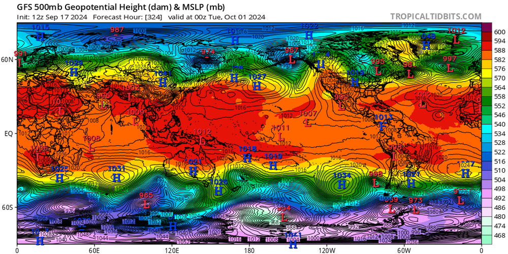
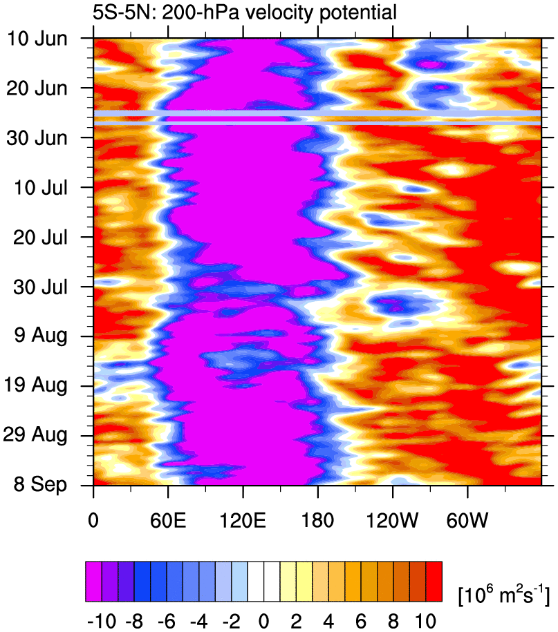
Some rather significant weakening in the VP anomalies around the Maritime coming up on just about every model. This may be a rather brief but exceptional opening of the Atlantic/ Caribbean to tropical activity closing out the month into October.
Pretty decent cooling of waters to now just slightly above average around Malaysia (I think that is the country 120E, ~15N).
This is also the most impressive the Nina has looked thus far.
-
1
-
-
Ok now lets just translate this to 3 months from now... lol
It still does amaze me we can get better patterns in the off seasons then when winter hits it is like brick wall of nope.
-
 1
1
-
-
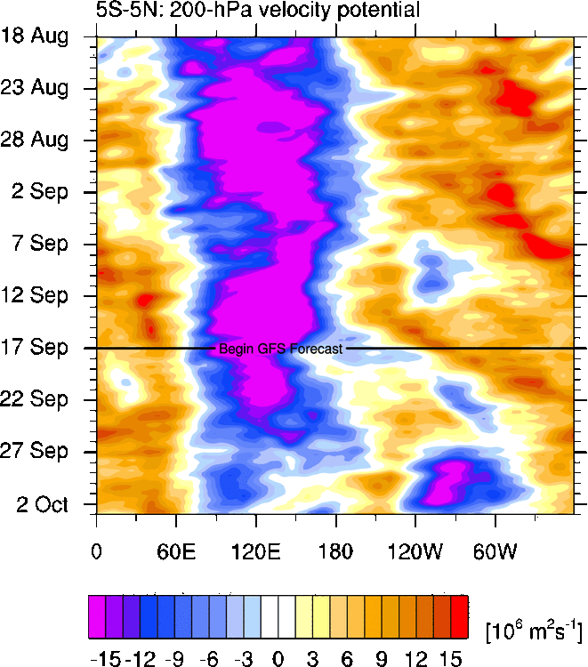
Here is the TAO and CPC update for subsurface. Again interesting to see the differences between TAO and CPC even going from 2N-2S to 5N-5S look.
You can see the relaxation in both though through August. The TAO data has less operational buoys in the east (I believe they can turn these on and off remotely, unless they are doing maintenance) so it gives the subsurface depiction a different look from CPC.
.thumb.gif.a7366b7a6e823dd21415733c6d3b6e60.gif)
.gif.e6d74cefa185b69a04b23844051b20fe.gif)
-
1
-
-
Slightly down for the PDO in August numbers. Probably has to do with some weakening/moving of the warm blob around Japan and the eastern portions (NE PAC) virtually neutral. Let see how it goes into the rest of Fall, probably won't go below -2 the rest of the year without a big surprise which seems unlikely unless we get a very solid -WPO pattern set up.
-
Beautiful radar presentation. Might be able to achieve low end cat 2 status briefly.
-
Just now, PhiEaglesfan712 said:
I don't know if I said this before, but anti-2007 gets us an el nino:
I am unsure. I do my best to pay attention to what folks say in here but I unfortunately have a lot going on outside of this to where I can only keep up so much.
-
1 hour ago, snowman19 said:
Even though 13-14 (cold-neutral) was “technically” a -PDO it sure did not behave like one on the PAC side, in fact, it exactly mimicked a +PDO and a real strong one at that. The PAC SST configuration was completely different than what we are seeing now, which caused that very strong +PDO/+TNH response. Classic +TNH in fact. @bluewave made a post a little over a month ago explaining the reasons for it. The Atlantic side is definitely similar and it ended up being ++NAO/++AO that winter. It was all Pacific driven
It was a rather massive change in SST's that year alot can still happen.

-
1
-
-
Also besides the tropical system near the Bay of Campeche, which may become a hurricane if it can spend enough time over waters, we should see at least one more tropical system form in the Atlantic within the next week given the relaxation in the positive VP that has plagued us this year. Honestly it probably is a good thing, most folks do not want to deal with intense tropical activity especially since insurance is through the roof in many locations along the Gulf coast.
Current forecast and looking at past relaxations of +VP over the Atlantic they match up pretty well to a system being able to get going. Next potential if forecast holds up would be into the end of the month.

-
Just now, so_whats_happening said:
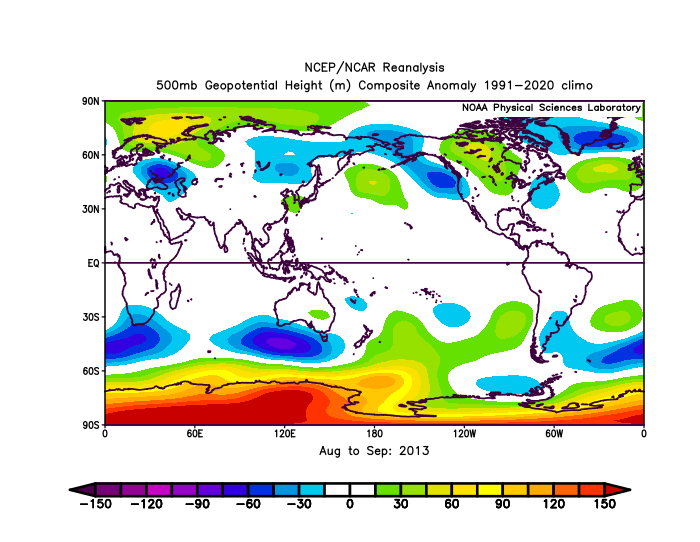
I feel like I have seen now a few times 2013-14 get thrown around. Quite interesting to say the least so far it is fairly close in matching this August/September 500mb pattern. Hurricane season ended up 14/2/0, we already had 1 major hurricane so there is that at least. Already had a pretty well established westerly QBO. -PDO was around, we are on a different magnitude of PDO right now but we shall see how it continues. Entering a solar max time period. A bit off on the subsurface look as this year has a bit more of negative subsurface.
Again just pointing out some similarities no real drive to make this a forecast. If models are right in signaling and we do indeed actually start to see more troughing occur onto the Pac NW this may be a year to throw into the consensus.
.gif.babeded2961834e7222b10c1932cc2da.gif)

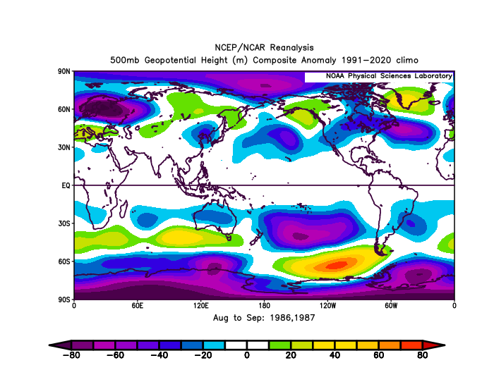
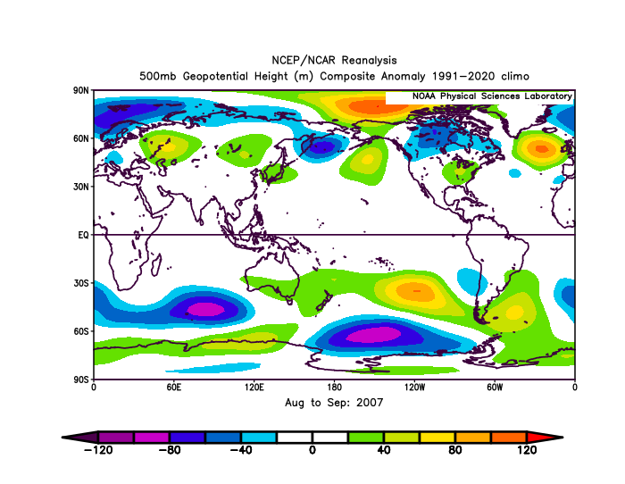
2007 is a bit off to me but here is the 500mb pattern for August/September. That year we had a late developing WQBO pattern, rather low solar year, the PDO was rather neutral except a random spike negative around October, subsurface was an ok match, the hurricane season put on quite the show. So it has some similarities maybe an anti 2007 would be better?
-
2
-
-
I feel like I have seen now a few times 2013-14 get thrown around. Quite interesting to say the least so far it is fairly close in matching this August/September 500mb pattern. Hurricane season ended up 14/2/0, we already had 1 major hurricane so there is that at least. Already had a pretty well established westerly QBO. -PDO was around, we are on a different magnitude of PDO right now but we shall see how it continues. Entering a solar max time period. A bit off on the subsurface look as this year has a bit more of negative subsurface.
Again just pointing out some similarities no real drive to make this a forecast. If models are right in signaling and we do indeed actually start to see more troughing occur onto the Pac NW this may be a year to throw into the consensus.
-
4
-
-
13 hours ago, bluewave said:
One of the possibilities is that the record Mediterranean and North Atlantic SSTs can shift the ITCZ further north than usual.
Im not sure yet on the idea the N ATL is playing a role in moving ITCZ north but feel the Mediterranean warming so much is definitely an effect from a north moving cell. What may be causing that northward progression im not too sure and I don't believe many can pin point something so easily just yet. Have those countries on the north end of the Mediterranean seen any type of increase in drought conditions? I know this is hard to tell in a climo like they have but would be interesting to see if that is the case.
As you know with most things in this science we don't know the outcome until it has happened several times over and get a better understanding of what caused it.
-
1
-
-
14 hours ago, snowman19 said:
If you look at when the upper tropospheric temps really started to rise, it was right when the solar flux/geomag and UV started spiking, not a coincidence
While Im sure Solar does have some impact you also see a rather large spike around the 2009-11 area this was during a solar min so not always does solar tell the tale so it seems. It may be a contributing factor in helping enhance whatever is going on at the time.
-
7 hours ago, raindancewx said:
These cold shots in the East are actually consistent with the pseudo Modoki El Nino look we have at the moment. Nino 3/3.4 aren't really below 1961-2020 averages meaningfully, but Nino 4 is well above 1961-2020 averages.
This very much, I was saying something about this a week or so ago that the northern hemisphere even with the -PDO had a fairly Nino like look to it. The NAO domain was in near opposites to last year but everything else almost a near match in the northern hemisphere. The NAO is probably the big reason why the hurricane season has been rather lack luster in the Atlantic for the last month. Big reason why the Atlantic was going nuts with storms in an El Nino was the ability to have a -NAO during August into September and the SST's were rather primed as well. We didn't have many go west of the Islands but the number of storms was there.
What is funny enough though is last year was also rather cool in August but our MJO was moving through 7/8/1. This is really starting to further a point of maybe there really is a strong disconnect between tropics and mid latitudes. 1 year won't determine everything of course but it is interesting to see none the less.
-
4
-
-
-
8 hours ago, bluewave said:
One of the reasons the Atlantic has been so quiet last few weeks is due to the ITCZ shifting north into the Sahara.
I forget where exactly I read about the potential with a warming world to produce a greening Sahara. Maybe it was the exxon 1982 study that got circulated.
-
DCA _ NYC _ BOS __ ORD _ ATL _ IAH __ DEN _ PHX _ SEA
.9 .5 .1 -.2 .4 .8 1.0 1.4 2.5
-
1
-
 1
1
-
-
6 hours ago, 40/70 Benchmark said:
A large proportation of the annual snowfall on the east coast is dirty...meaning that it isn't produced via a Benchmark bomb....imperfect set ups that yield messy returns is how a lot of it comes.
Yea it is quite hit or miss around here. We play the WAA game with guessing just how strong and quick it happens before we switch.
3 hours ago, brooklynwx99 said:the farther south you go, the more luck is a factor as well. people don't really like to admit that since it isn't really quantifiable, but it's true
I mean I can see the drastic differences from Allentown to Lancaster to Baltimore and that is about 100mile ish difference in total. You can see the difference back in the day between Allentown and Philly, although I don't live over that way anymore we used to set up right on the edge around King of Prussia while Philly switched and Allentown was getting buried. Even from Lancaster to Baltimore I usually can guess where the rain/snow line typically sets up now and it has retreated in these borderline events further North and West.
Cant say with certainty every storm will end up that way but when we see 2-3x Baltimore snows it becomes noticeable much more so when Baltimore only sees a 4" season and we are barely scraping a foot on the year. Definitely makes forecasting hard around here from about Trenton south to DC and west to about Harrisburg.
-
12 hours ago, donsutherland1 said:
Yesterday, Arctic sea ice extent fell to the third lowest for August 27th on JAXA. At present, it appears that 2024 will become the fourth year to record a minimum figure under 4 million square kilometers. 2012, 2019, and 2020 are the other years with minimum figures below 4 million square kilometers. The decline despite less than hostile conditions illustrates the importance of thickness. Thin ice melts out more easily. Winter recovery means little if the ice remains thin.
Climate change deniers often point to winter ice recovery to make bold and ultimately futile claims that Arctic sea ice is recovering. One such example was fact checked back in May, and now looks even more foolish in light of the most recent data.
That is rough to see not a great look for Millersville, unfortunately I know the lead Meteorologist in the weather station and not a big fan to say the least. This fits right into his beliefs.
-
1
-
-
21 hours ago, GaWx said:
To be quite honest I just had a conversation about this last night. Quite weird to say the least especially going through a phase 1-2-3 MJO and not getting a single storm to pop in the Atlantic? Yet the EPAC and WPAC tossing out storms. There really does seem to be some strong disconnect happening and it really could be these marine heatwaves bluewave has been mentioning throwing things off.
2 hours ago, brooklynwx99 said:it would be hilarious if this winter ended up good for many people even though there were vibes and evidence to the contrary. I remember 20-21 was like that
for the record, I do not expect a good winter in the NE (especially outside of New England), but it would be funny... and definitely welcome
I think I would laugh so hard if this happened because I know seasonal forecasting is extremely tough let alone doing past 5 day forecasts. I like the confidence folks have on here but we really need to know things will not go as planned.
-
4
-
1
-
-
8 hours ago, GaWx said:
1. Agreed it will very likely be closer to avg on Sept 1. However, the 3 main 0Z ensembles as well as 6Z GEFS agree that the highest concentration of members with a TCG is in the MDR 45-60W between 8/31 and 9/3. Overall concentration looks a bit higher vs most earlier runs. This is pretty close to when/where 23 AI-Euro runs in a row had TCG as well as TCGs on recent ICON runs. Chances seem pretty good for the next TCG during the first few days of Sept. even though the AI-Euro ironically abandoned its near Leeward Island TCG two days ago. So, we’ll see. If there is a TCG then when considering the near record warmth in many parts of the W basin, that would have the potential to be a big ACE producer. Unfortunately, it could threaten the CONUS. I’ve been enjoying the lowered stress resulting from this recent quiet. The party may be over. We’ll see.
2. I believe that this season will end up backloaded as well as concentrated in the W part of the basin due to less favorable conditions in the E basin due to a variety of reasons, some unknown.
Yea there seems to be a sneaky wave showing up on models that gets into the east/central Caribbean by the end of the weekend into early next week. Seems to be out of that clustering around 30W that models want to try and latch onto. Forward progression seems to be finally slowing down a bit across the MDR instead of things flying by.
I feel like many call things far too early with tropical season anymore, not saying it will but this season could easily last into November and December. Meanwhile the WPAC continues the typhoon train. I would not be surprised if we start to see two distinct warm pools one just S and SW of the Aleutians (slowly moving east) and one back toward mainland China and the Koreas. Some of the Sea of Japan (at least eastern portions) may contend with some cooling coming up.
-
1
-
1
-
-
5 hours ago, bluewave said:
The La Niña background state is so strong that it’s actually creating easterly shear in the Atlantic. This is why the models are quiet for late August instead of very active which we usually see during La Ninas. So we’ll have to wait until September for our next period of tropical development.
https://michaelrlowry.substack.com/p/the-bell-has-rung-so-why-are-forecastToo much of a good thing?
As regular readers of this newsletter know, wind shear – the change in wind direction or speed with altitude – is one of the big hurdles to tropical development. Typically it’s the strong winds at upper levels (30,000-40,000 feet) which blow from west to east (known as upper-level westerlies) through the deep tropical Atlantic and the Main Development Region or MDR that create most of the wind shear issues.So when upper-level winds in the tropical Atlantic turn more east-to-west (easterly winds) and against the west-to-east grain, it usually helps to reduce wind shear, which in turn favors hurricane development. This is especially true during La Niña years like we’re experiencing and when rising air settles in over Africa and the North Indian Ocean as it has recently – a big upper-level disturbance we track across the tropics called the Madden Julian Oscillation or MJO.
The combination of La Niña with the part of the MJO that usually reduces wind shear would normally suggest a conducive period for development. However, the upper-level winds have switched so far out of the east that they’re creating easterly wind shear issues across the Atlantic, an unusual problem not often seen in the basin.
It means that the MJO will need to move to a less conducive phase to bring back the seasonal upper-level westerlies and tamp down on easterly shear issues plaguing the basin right now. The easterly shear is also worsened by the low-level westerly winds from the northward displaced ITCZ we discussed earlier.
The MJO naturally propagates eastward across the globe and extended range models are already showing the easterly shear issues abating toward the end of the month.
So when will activity pick back up?
Putting all the pieces together, it should be another week or two before the current impediments clear out.
It’s possible our next spurt of activity is delayed until the beginning of September, but we should see the transition as August comes to a close late next week.
Traditionally 70% of tropical activity, including most hurricane formations, happens from September onward. Still a long way to go in the game, but for now we’ll soak up the unforeseen late August lull.
Almost every storm that has come from Africa this year has been flying through the MDR into either the SW Atlantic or Caribbean. Beryl being at such a low latitude going through flow at 20-30mph is impressive even for early in the season.

.gif.5edbef656cac344e9d43283a9975550a.gif)


2024-2025 La Nina
in Weather Forecasting and Discussion
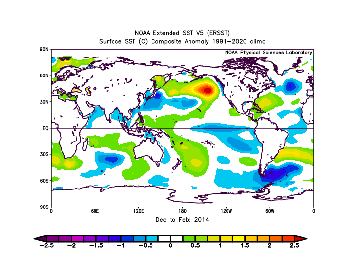
Posted
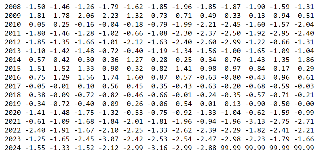
Yea it is possible, if this would happen it would surpass 2011 and start to rival the one month anomaly of Oct 1955 where we got to -3.35. Fairly similar placement as for the most extreme SST anoms.
How have the models faired so far in extended forecasts? Just curious this is not something I follow all too often.