so_whats_happening
-
Posts
1,588 -
Joined
-
Last visited
Content Type
Profiles
Blogs
Forums
American Weather
Media Demo
Store
Gallery
Everything posted by so_whats_happening
-
2026-2027 Super El Nino
so_whats_happening replied to Stormchaserchuck1's topic in Weather Forecasting and Discussion
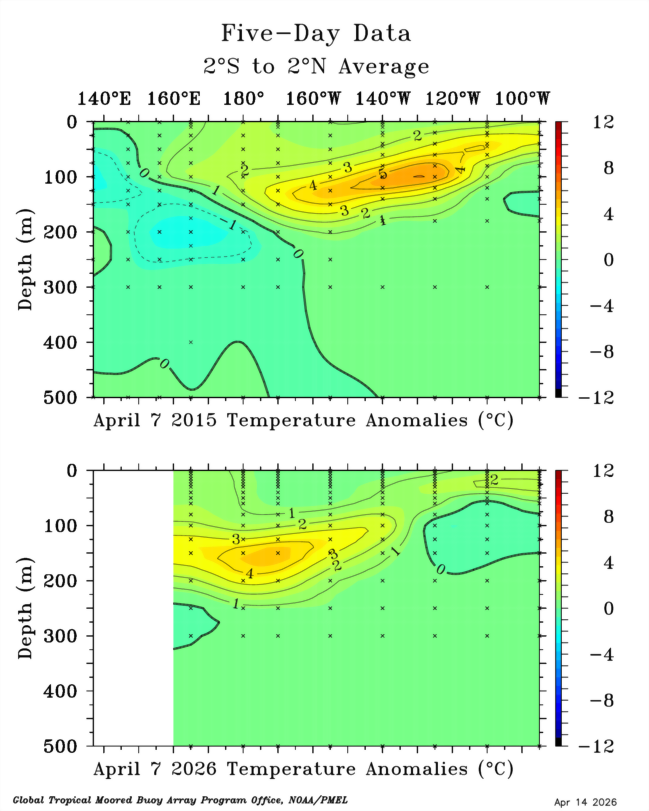
Sorry there is a gap around the 8th of April TAO never updated for me.thumb.gif.17702c19c0f1eb7b5b3f05793a922e6d.gif)
-
@dmillz25 @Stormchaserchuck1 @Rjay
-
2026-2027 Super El Nino
so_whats_happening replied to Stormchaserchuck1's topic in Weather Forecasting and Discussion
That is why it is important for the 500mb to react in the proper manner so things do actually connect. Just because a precursor occurs to create this Strat warming/+GPH pattern but nothing actually sticks at 500mb than you just get warming aloft and nothing connecting. In my mind 23-24 had all the right things going for it but the 500mb atmospheric pattern was flat out wonky given the upper atmospheric pattern taking shape. -
2026-2027 Super El Nino
so_whats_happening replied to Stormchaserchuck1's topic in Weather Forecasting and Discussion
This is why it is important to get a solid Wave 2 attack on the SPV like we would typically like to see for that winter potential is you need to have the pacific pattern also in conjunction with the developing -NAO. As I see above the talk about the NAO and the lack there of, at least with consistency, is a huge factor in just continuing with the large scale wave 1 patterns attacking the SPV. The 500mb pattern is important in that regard not necessarily the overall warming/+GPH that takes place in the Strat.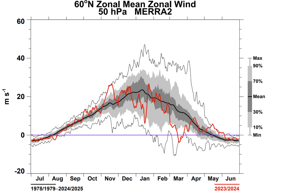
-
2026-2027 Super El Nino
so_whats_happening replied to Stormchaserchuck1's topic in Weather Forecasting and Discussion
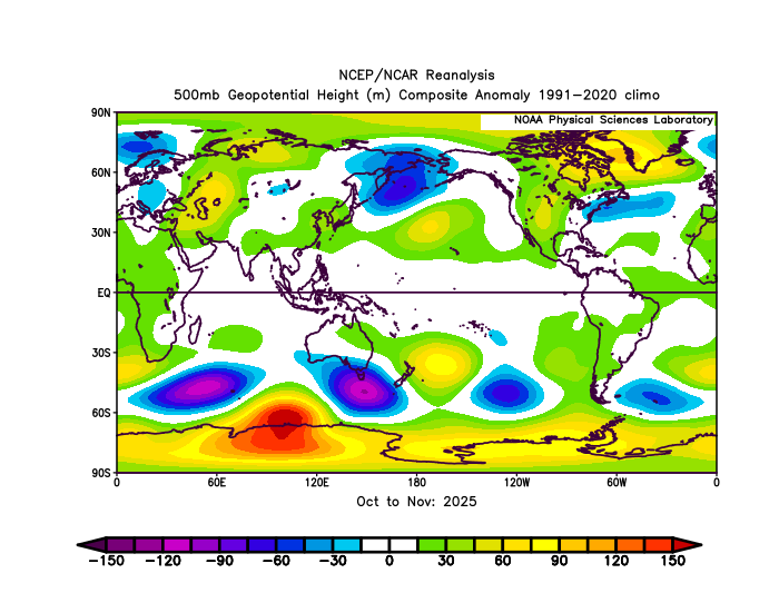
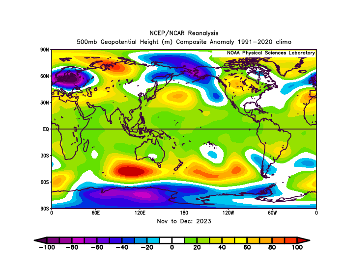
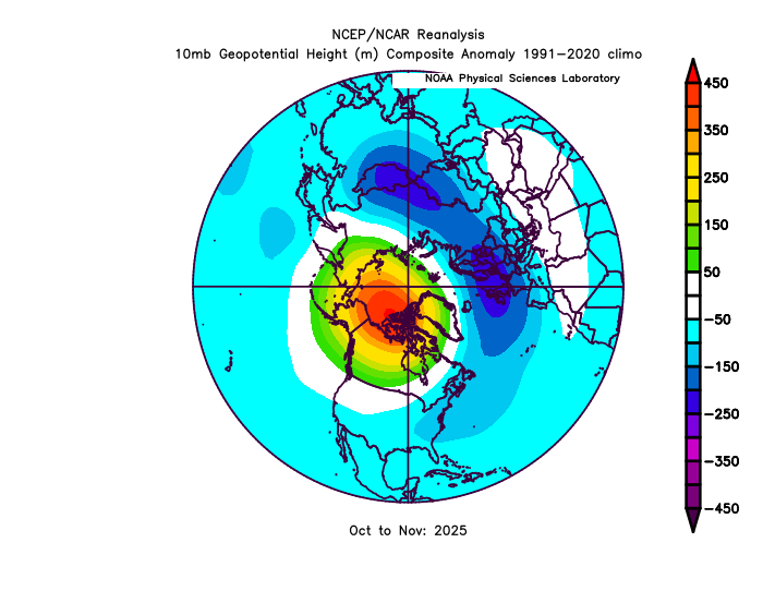
It did not the SPV was stronger to start than this past year but had a very similar large wave 1 like this past year about a month apart from each other. 25-26 November while 23-24 had it in December. Look at the difference leading into both SSW events at 500mb. 23-24 had an atmospheric pattern at 500mb not conducive to sustain the ridging like we would want to see. 25-26 set it up and finally connected in the Nov-Dec 500mb pattern which is exactly what we would want to see occur. Both had very similar Stratospheric ridging patterns but very different 500mb patterns existed thus leading to different results. Both years were in deeply negative PDO territory rising as we got to winter, this past year was some lowest numbers recorded. Both years had a -QBO state at 30mb and were descending (2023 was a tad bit later but still negative during these times). You could make the argument that this past year had more of an El Nino kick to the atmosphere than the year where we had a strong/super Nino.
-
2026-2027 Super El Nino
so_whats_happening replied to Stormchaserchuck1's topic in Weather Forecasting and Discussion
I think 23-24 didn't pan out in the way we had hoped even given similar SSW styles to this past year was the SPV was just that much stronger that year so it needed quite a bit more to really knock it down. Again unfortunate but it is what it is sometimes. -
2026-2027 Super El Nino
so_whats_happening replied to Stormchaserchuck1's topic in Weather Forecasting and Discussion
We tend to box things in a lot with these oscillations which is unfortunate but understand why it is done. -
2026-2027 Super El Nino
so_whats_happening replied to Stormchaserchuck1's topic in Weather Forecasting and Discussion
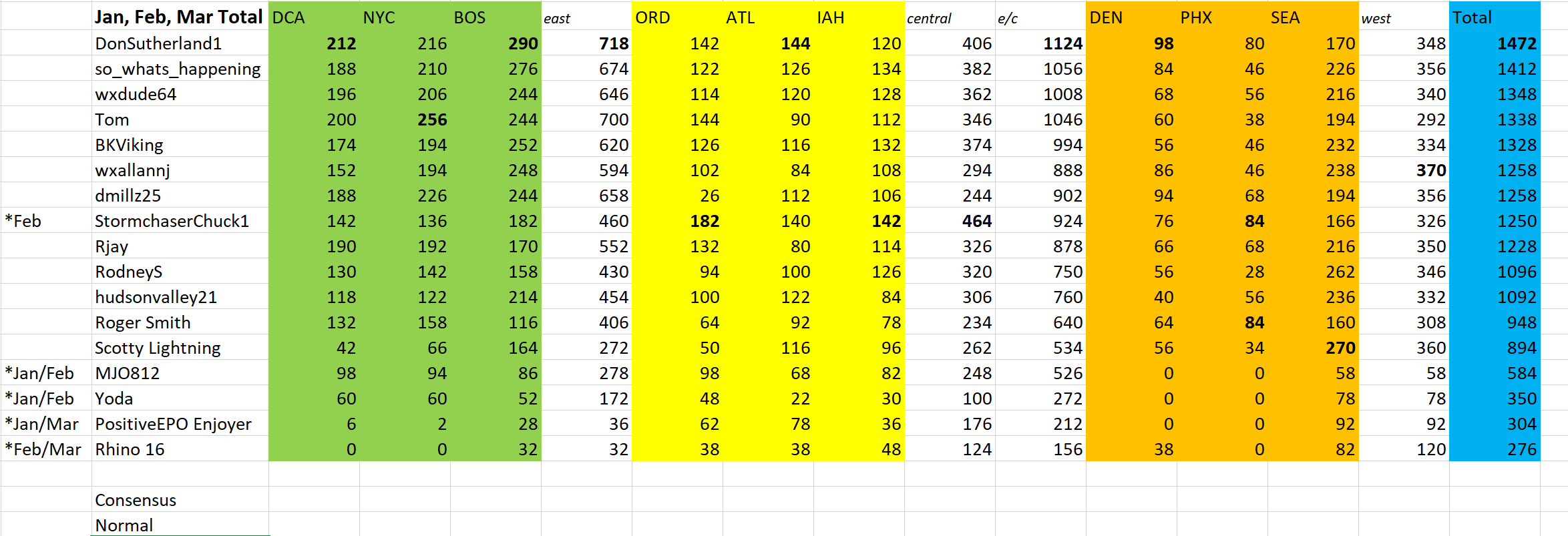
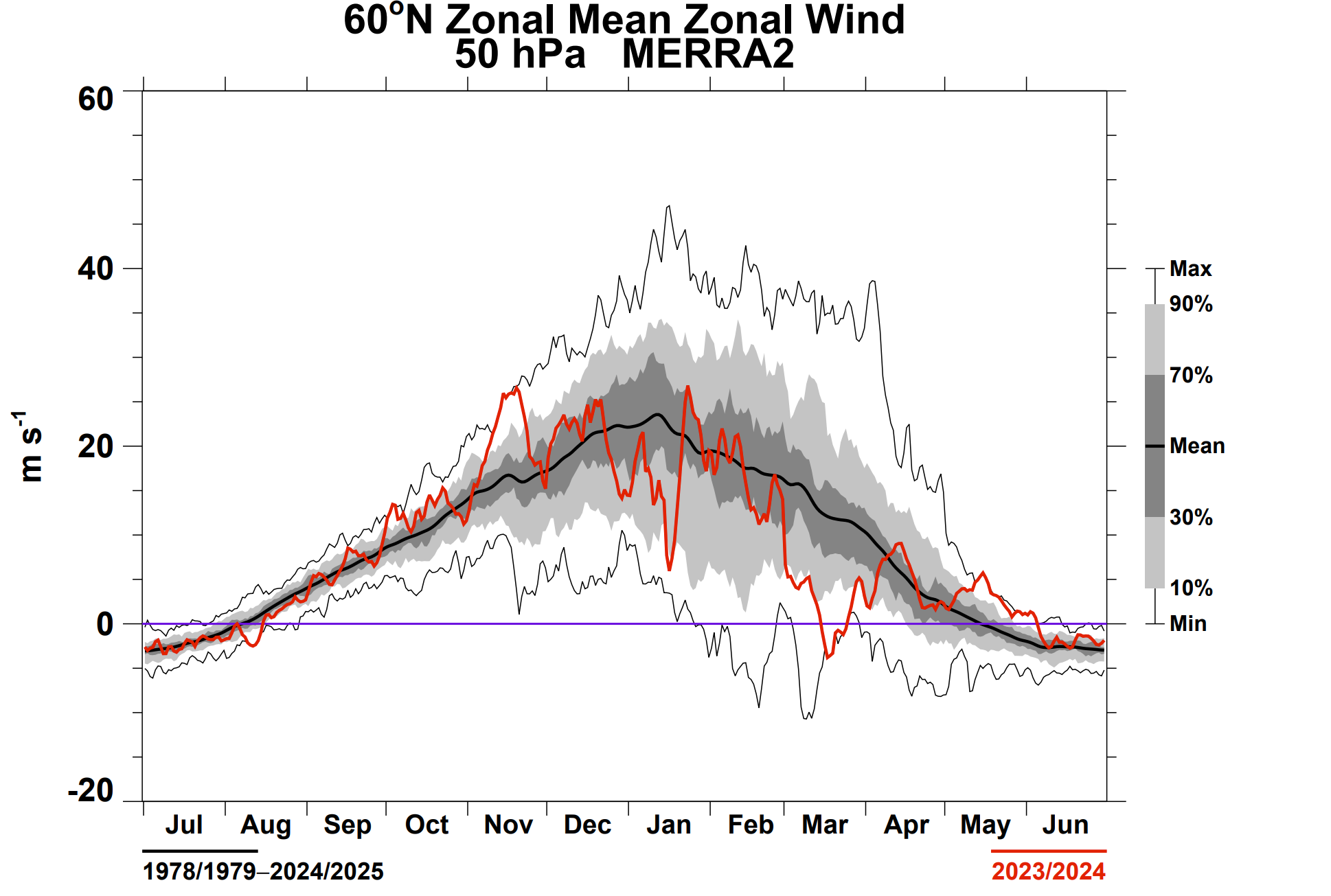
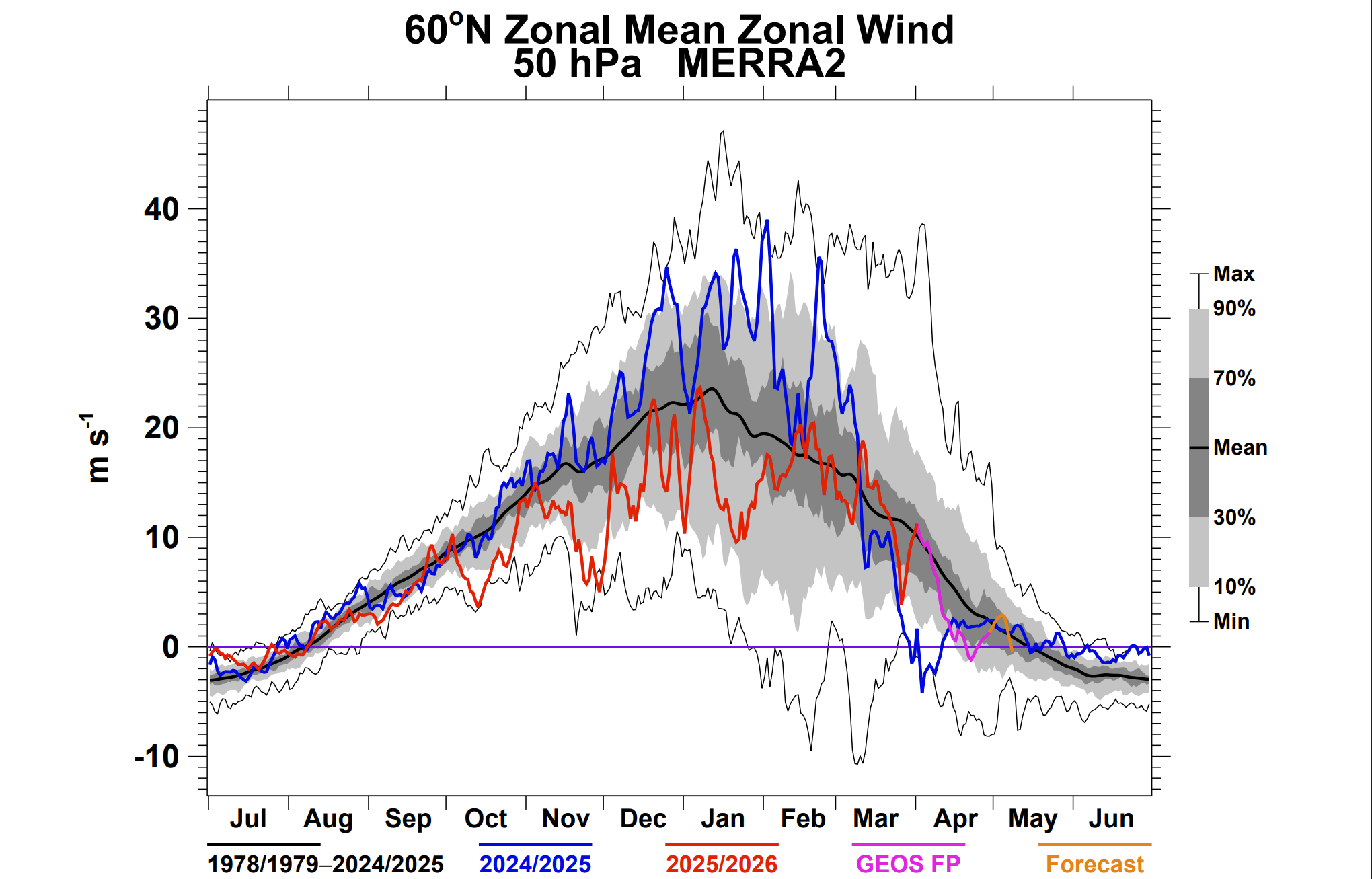
I think what has been more intriguing to me has been the SSW formations and the results. The last two have been massive wave 1 approaches to an SSW event. While this last year can be considered an SSW it was not due to a major heat flux like we traditionally would see from these events. It was in tandem with the 500mb pattern of a slow build up of atmospheric ridging that eventually coupled, not a lot of warming was involved with this one. Sort of a bottom up approach from the typical quicker top down events. We actually had something fairly similar happen this year to what occurred in 2009 where the early SSW was disturbing the SPV and thus keeping it weaker overall at the start of the season but in 2009/10 we had a large heat flux later on in the year. That second more prominent SSW event with heat flux completely obliterated the SPV for the season leading to what we saw that year of an overly extended winter and we just so happened to have the precip aspect work in our favor. Maybe this large bubbling of Wave 1 activity giving us these SSW's is newer in the climate of a warming world but would like to see how things progress in the near future. I don't think wave 2 events are done for but it has been pretty difficult to get one to actually occur. There tends to be a lag from early season SSW events I'm not sure about the 2-3 month number but there is a lag into effects downstream from those. vtn_50_2025_merra2.pdf vtn_50_2009_merra2.pdf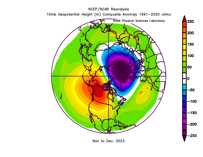
-
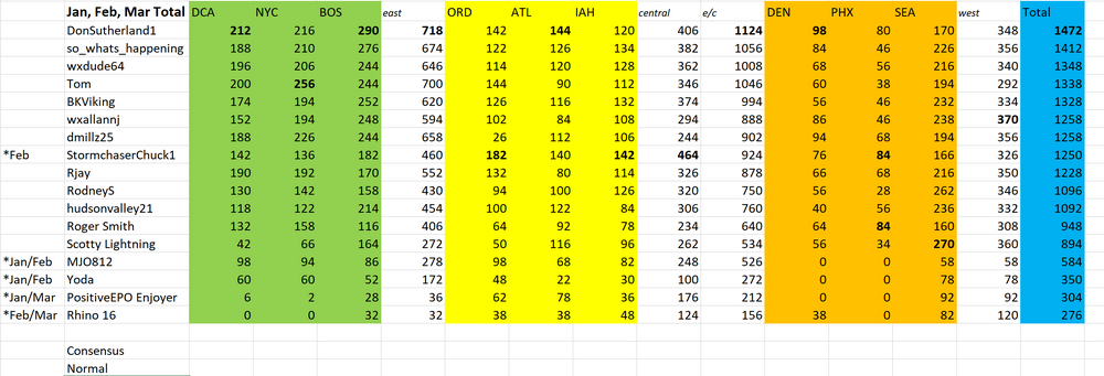
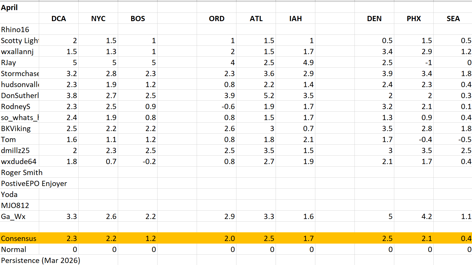
DCA NYC BOS ORD ATL IAH DEN PHX SEA +1.4 +1 +0.7 +0.8 +2 +1.7 +1.7 +2.2 +2.5
-
Saved for April final tally and Jan-Apr totals Below will be forecasts for May. Just as a reminder to have forecasts done by May 1st 6z. Penalties will be every 6 hours after 6z of 1% off total at the end of the month of May.
-
Updates through 4/18 DCA NYC BOS ORD ATL IAH DEN PHX SEA +8.2 +5.6 +3.1 +6 +7.6 +4 +3 +5.5 +0.3 +6 +4.5 +2.5 +5 +6 +3.5 +2.5 +4.5 +.5 Most places in the east and plains should cool slightly from these values above over the next couple days and essentially remain steady to the end of the month. In bold are the values I would expect to see for these locations by the end of the month to give you an idea where we may stand. I will add normal and consensus at the end of the month and update the January-April totals to reflect it as well. I also will tally up the snowfall forecast we had this past season as we progress through mid May to make sure we don't get any surprise snows in the front range over the next month.

-
2026-2027 Super El Nino
so_whats_happening replied to Stormchaserchuck1's topic in Weather Forecasting and Discussion
Well this was quite the surprise to see https://psl.noaa.gov/enso/mei/ Feb/Mar MEI at -1, responses were starting to show in March but I will be curious if Mar/Apr will start to move toward neutral at least. While oceanic response seems to be there atmospherically something is off. -
2026-2027 Super El Nino
so_whats_happening replied to Stormchaserchuck1's topic in Weather Forecasting and Discussion
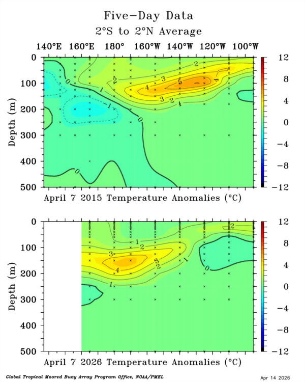
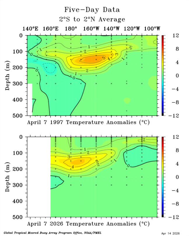
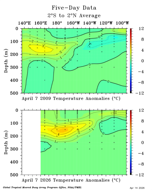
The depiction of the subsurface alone would make me think at this early stage we are further west than two of the stronger Nino events in the last 30 years.

-
2026-2027 Super El Nino
so_whats_happening replied to Stormchaserchuck1's topic in Weather Forecasting and Discussion
Here are some depictions for specific years in comparison to this year.
-
2026-2027 Super El Nino
so_whats_happening replied to Stormchaserchuck1's topic in Weather Forecasting and Discussion
Unfortunately had a large gap in data for TAO recently but here is the 2N-2S TAO depiction of the subsurface. Reminder that CPC and TAO are different in coverage but overall represent things similarly..thumb.gif.4af85b9e0a5bef754d00ff42fc8fde1f.gif)
-
2026-2027 Super El Nino
so_whats_happening replied to Stormchaserchuck1's topic in Weather Forecasting and Discussion
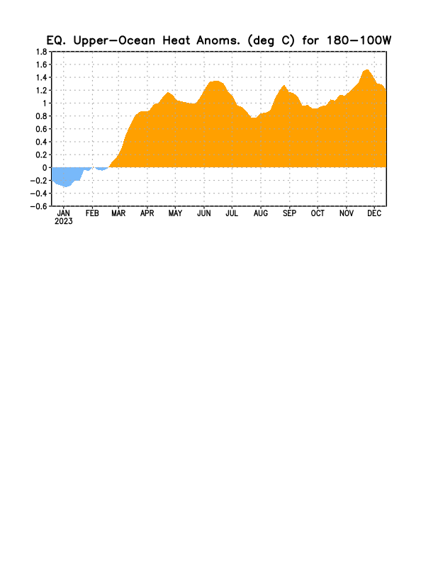
2023 OHC for reference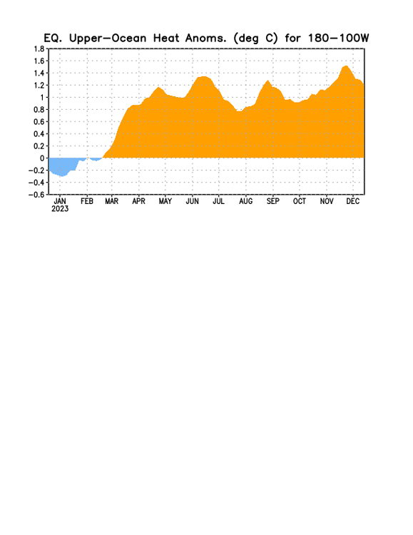
-
Happy Easter. Here is a look at the monthly forecast, best of luck everyone. I will try to update consensus and normal into season totals and future updates, for consensus I just did median of the forecasts for each city. This seemed to be as close as I could get to consensus scoring as Roger did. I'll try to figure out how he did persistence going forward. Welcome Ga_Wx hope to see you more often. Starting in May we will continue on with forecasts submissions before May 1st 6z as we have done before. I will be a little lenient on penalties of 1% off every 6 hours late at first. Look to June forecast to be the time frame we do MAX temp forecasts for summer.
-
Seattle forecast 0.4 or 0.6?
-
Not a problem thanks for the forecast. @donsutherland1 @MJO812 we will be starting May forecasts to be due back at May 1st by 6z and each month after for the future. Would love to see everyone still participate but of course life happens. I will do my best to make it as close to what Roger was trying to do for these contests as we go along.
-
Awesome if you have time to drop a forecast this weekend we will keep late penalties out for this one.
-
Forecast by 6z 4/3 essentially 3 hours from now. Going forward we will be doing this on 1st of each month by 6z.
-
@dmillz25 @donsutherland1 @MJO812 @yoda let me know if you would like to still continue doing the monthly temp forecasts.
-
I did it for April 3rd @6z to get back into the swing of things but come May and onward we will go back to by the 1st at 6z.
-
Before I forget mine: DCA: +2.4 NYC: +1.9 BOS: +0.8 ORD: +0.8 ATL: +1.5 IAH: +1.7 DEN: +1.3 PHX: +0.9 SEA: +0.4
-
From January scores done by Roger, February done by wxdude64, and March done by myself (just above) here are the standings as of the end of March. I hope this is all correct and this should become much smoother as we move forward. Bolded are the tops scores in each category. The asterisk is for months that were missed. We have quite the grouping going on and love to see newcomers each month. I will send out a message to folks about April who see missing thus far.
.gif.9bc3c274502e7fceb9f1dbc69cab2d3c.gif)


.gif.1295f9b434b2f02b54e4db7fb38642c0.gif)