

so_whats_happening
-
Posts
1,076 -
Joined
-
Last visited
Content Type
Profiles
Blogs
Forums
American Weather
Media Demo
Store
Gallery
Posts posted by so_whats_happening
-
-
Just now, Bubbler86 said:
That is right, thank you. Do you know dates and if the Nam is totally off?
Unfortunately no but I would assume this may be the last winter for it as they fine tune FV3 more. Im sure it will still be in running just not in the spot light.
-
 1
1
-
-
31 minutes ago, Bubbler86 said:
Count me on the Nam train as well. Also, I frequently rely on the HRRR for pinpoint forecasts, but its depiction of the columns was off on this one.
And to think they are turning the Nam off.....sigh.
29 minutes ago, paweather said:Upgrading it to something else?
22 minutes ago, Mount Joy Snowman said:Haha right. In all seriousness, I was thinking it may serve as like a 10-15 minute lead time.
Whoa whoa whoa, come again. Please elaborate on said NAM extermination. Perhaps I was caught out of the loop but haven't heard about this one. That would be terrible, IMO.
NAM is to be replaced by FV3
-
 3
3
-
-
8 hours ago, anotherman said:
Let’s be honest, people are only annoyed with Elliot from MU because he usually crushes our snowy dreams. I guarantee you no one would complain about him if we were getting plastered regularly.
Haha thats pretty funny. I actually went to school with him. Had horst as the lead forecaster when I was there.
-
 1
1
-
-
26 minutes ago, 40/70 Benchmark said:
The point is that on average a neg NAO pattern is colder than a positive NAO pattern. That is different than saying that the NAO is the vehicle for the delivery of the cold. That isn't what I intended to imply...not sure about anyone else.
That statement solely relies on the pacific pattern at the time and serves no other purpose other than to shift the storm track further south. I think a better statement would be it gives opportunity to have colder air to funnel with a -NAO versus a +NAO if the pacific pattern cooperates enough leading into the development of the NAO (whichever phase comes about). I feel we have been far too lucky with getting a -EPO/+PNA pattern within a -NAO regime that it gives us this sense cold will be there when we get a -NAO, hence a big reason many associate the -NAO with a cold pattern.
Honestly with all this talk none of this was even remotely intended toward you, you just happen to think the statement was about what you had said, not entirely sure why you felt that way but hey to each their own. I wanna say raindance's comment of -NAO was in jest toward the lot of people saying it will be a December to remember as is usually the case pointed out almost every year and then on top of it posting GFS maps of warm anomalies as we are transitioning into a west based -NAO during that timeframe. GFS unfortunately is a bit wonked out of its mind right now 0 consistency run to run so it was in bad taste.
-
 2
2
-
-
11 hours ago, GaWx said:
I think the following might be of interest as I happened to have recently looked at the December 1-15 temperature anomalies at Raleigh-Durham, NC, (RDU) for the seven years since 1950 with an -NAO of -1 or stronger averaged out for the period 12/1-15 (year: average NAO for 12/1-15, RDU temperature anomaly):
1963: -1.5/very cold -7
2009: -1.3/cool -2
2010: -1.2/very cold -12
1977: -1.1/cold -5
1989: -1.1/very cold -7
1995: -1.1/cool -2
2002: -1.0/very cold -9
*Average was a cold -6
*None were mild. All were colder than normal with 5 of 7 cold to very cold.
*2010 with -12 was the coldest of these and yet it somehow did this with a PNA way down at -1.0, the 4th lowest 12/1-15 PNA since 1950! The lowest 12/1-15 PNA since 1950 isn't that much lower (-1.2 in 1972).*2022's 12/1-15 NAO/PNA combo is forecasted by the GEFS to end up by far the closest to 2010 vs any other year since 1950. The latest forecast is for an NAO of ~-0.8 to -0.9 and a PNA of ~-1.1. In 2010, the NAO was -1.2 (3rd lowest since 1950) and the PNA was -1.0 (4th lowest PNA since 1950).
*But despite the similarity to the NAO/PNA of 2010, the latest forecast temperature anomaly for RDU for 12/1-15/2022 is for it to average significantly warmer than normal, the opposite of 2010's extreme cold! With it only December 5th, the actual 12/1-15/2022 is still somewhat up in the air especially considering that this is a difficult pattern to forecast. Regardless, the period as a whole clearly isn't currently looking cold even with the possibility of it ending cold and thus looks to be far different from 2010.
RDU temperatures:
https://www.weather.gov/wrh/Climate?wfo=rah
Daily NAO since 1950:
https://ftp.cpc.ncep.noaa.gov/cwlinks/norm.daily.nao.cdas.z500.19500101_current.csv
Daily PNA since 1950:
https://ftp.cpc.ncep.noaa.gov/cwlinks/norm.daily.pna.cdas.z500.19500101_current.csv
Yea 2010 was a bit of an oddball situation with a -PNA and -NAO and widespread cold. Not to say a -PNA/-NAO combo doesn't produce cold and at that coast to coast, it can and does happen just not very often. This year is different in that we did not have a -NAO leading up to that cold period like in 2010. We had a fairly weak -NAO if you want to call it that with similar ridging pattern in the Alaska region leading up to current time. So cold got to build up in the similar regions except now it is just being released along the west instead of across the country. Talk about anomalous -PNA though in 2010.
Here are the 2 weeks leading up to the end of November you can see the similarities between the two years except for one fairly noticeable difference and that is the lack of -NAO leading up to December this year. If we had that -NAO present it would have been able to funnel in the cold much better. We also had a very weak MJO basically null that month so not much influence in that department versus this year we have a more pronounced wave making its presence known and throwing curveballs at us.
-
1
-
-
13 hours ago, 40/70 Benchmark said:
No one said that. But all else being equal, it provides the cold with more staying power, which is why it is linked to colder patterns in the northeast on average. At present all else is not equal because there is no mechanism to drive the cold southeast as of yet.
It definitely was implied just a few posts above. Right a -NAO just provides staying power into a pattern if the cold got released in any other instance, it simply doesn't mean a cold pattern.
-
Little bit of cringe going on here.
It is well known -NAO does not bring cold temps into the US so im not sure where that is coming from. Didn't have a -NAO with the cold blast in November even with a neutral to negative PNA sticking around we reduced the heat anomalies easily by half. -NAO is all about storm track and slowing the forward speed of systems. I personally would rather take my chances with temps near or slightly above average as a whole than have a ton of cold pressing down east of the Mississippi. Suppression/depression with missed opportunities off the coast no thanks. Many areas need rain and would rather see the rain falling then see the constant bickering of no snow. Plus it is only December folks need to relax a bit.
-
1
-
-
DCA _ NYC _ BOS ___ ORD _ ATL _ IAH ____ DEN _ PHX _ SEA
-1 -1.2 -1.5 -1.4 +1 +1.8 -1.4 +1.2 0
DCA _ NYC _ BOS ___ ORD _ DTW _ BUF ___ DEN _ SEA _ BTV
18 38 64 45 38 110 42 11 84
Little late but wanted to do more of the snowfall contest than anything
-
1
-
-
16 hours ago, Roger Smith said:
===<<< _______(preliminary) Annual Scoring Report (Jan - Nov 2022) __________>>>===
Total scores for each location, region ... best scores for locations in red, for regions in bold type. The current status of this table is preliminary as November scores (above) could cange significantly. This table lets you know how those estimated scores play out but ranks may change.
So far, RodneyS has extended his lead while wxdude64 has moved into second place with DonSutherland1 close behind at third. Unfortunately so_whats_happening was unable to enter November and dropped from fourth to eighth. Consensus therefore moves up one rank to the gap between 3rd and 4th. Tom, BKViking, wxallannj and hudsonvalley21 have moved up to occupy 4th to 7th, in so doing wxallannj has also moved past hudsonvalley21. Scotty Lightning (9th and virtually tied 8th) is now ahead of RJay who fell to 10th, and your host remains in 11th. Normal has moved ahead of Rjay to occupy the gap between 9th and 10th. Stormchaser Chuck's prorated score would still leave him in 12th. so_whats_happening now has a prorated score also, and that would rank third. It should be noted that all of these ranks are subject to change at the end of the month.
FORECASTER ___________ DCA_NYC_BOS__east_ ORD_ATL_IAH __ cent _ c/e __ DEN_PHX_SEA __west __ TOTAL
RodneyS ________________816 _782 _668__2266__714 _900 _656__2270 _4536 __772 _888 _744__2404____6940
wxdude64 ______________ 763 _815 _793 __2371 __791 _813_ 634__2238_4609 __688 _832 _687 __2207 ____6816
DonSutherland1 ________ 852 _816 _776__2444__790 _748 _564__2102 _4546 __600 _844 _780 __2224 ____6770
___ Consensus ___________770 _788 _756__2314__762 _764 _584__2110 _4424__720 _824 _715 __2259 ____6683
Tom _____________________ 775 _809 _723 __2307__766 _761 _679__2206 _4513 __737 _723 _596 __2056____6569
BKViking ________________ 756 _796 _714 __2266__732 _730 _554__2016 _4282 __762 _748 _710 __2230____6512
wxallannj ________________682 _734 _694 __2110 __726 _640 _562__1928 _4038 __760 _778 _752 __2290____6328
hudsonvalley21 __________692 _760 _796 __2248__696 _722 _552__1970 _4218__ 658 _818 _612__ 2088____6306
so_whats_happening (10)_644 _702 _698__2044__693 _718_560__1971 _4015 __ 664 _768 _744 __2186 ____6201
Scotty Lightning _________730 _760 _706 __2196 __738 _710 _610__2058 _4254 __624 _784 _538__1946____6200
_____ Normal _____________760 _736 _616 __2112 __732 _742 _650 __2124 _4236 __588 _754 _566__1908____6144
RJay _____________________656 _702 _770 __2128__649 _696 _510__1855 _3983 __716 _630 _649 __1995____5978
Roger Smith _____________678 _632 _470 __1780 __582 _634 _558__1774 _3554 __820 _804 _771__2395____5949
Stormchaser Chuck (8/11)_497_509 _473 __1479 __450 _551 _355 _1356 _2835 __416 _510 _335 __ 1261____4096
__ __ prorated Stormchaser Chuck would compare at 5632 total points.
__ __ and so_whats_happening would compare at 6821 total points.
=========================================
__ Best Forecasts __
* tied for high score with one other forecaster __ ^ tied for high score with three others (Mar).
FORECASTER ________ DCA_NYC_BOS _east_ ORD_ATL_IAH_ cent _c/e__ DEN_PHX_SEA _west _ total
RodneyS _______________ 2**__ 1 ___ 1*____ 1 ___ 1 ___ 5 ___ 2 ___4 ___ 3___ 2*___ 1 ___ 2 ___ 1*___ 1 __ Sep,Oct
wxdude64 _____________ 0 ___ 0 ___ 2 ____ 0 ___ 1*___ 1 ___ 0 ___ 0 ___ 0 ___ 0 ___ 1 ___ 0 ___ 0 ___1 __ Jan
DonSutherland1 ________4*^__ 2 ___ 0 ____ 1 ___ 1 ___ 0 ___ 1 ___ 0 ___ 1 ___ 0 ___ 2 ____4 ____1 ____2 __ Feb,May
___ Consensus _________ 0 ___ 0 ___ 0 ____ 0 ___ 0 ___0 ___ 0 ___ 0 ___ 0 ___0 ___ 0 ___ 0 ____0 ___ 0
Tom ____________________ 1^___ 2 ___ 1 ____ 2 ____1 ___ 2 ___ 2 ___ 3 ___ 1 ___ 1*___ 1 ___ 0 ___ 0 ___ 1 __ Mar
BKViking _______________3^___ 0 ___ 0 ____ 1 ___ 2 ___ 1 ___ 1 ____ 1 ___ 1 ___ 1 ___ 0 ___ 0 ___ 0 ___ 1 __ Nov
wxallannj _______________ 0 ___ 0 ___ 1 ____ 0 ___ 0 ___ 0 ____1 ___ 0 ___ 0 ___2*___ 1 ___ 2*___ 2 ___0
hudsonvalley21 ________ 0 ___ 1 ___ 0 ____ 0 ___ 1*___ 0 ___ 1*___ 0 ___ 0 ___ 0 ___ 1 ___ 1*___ 1*___ 0
so_whats_happening ___ 1*___ 0 ___ 1 ____ 1 ___ 1 ___ 0 ___ 0 ___ 0 ___ 1 ___ 0 ___ 1 ___ 1 ___ 1*___ 1 __ Jul
Scotty Lightning ________ 2**__ 1 ___ 1 ____ 1 ___ 1*___ 0 ___ 0 ___1 ___ 0 ___ 0 ___ 0 ___ 0 ___ 0 ___ 0
___ Normal ______________ 3 ___ 2 ___ 1 ____ 1 ___ 2 ___ 2 ___ 1 ___ 1 ____0 ___ 0 ___ 2 ___ 1 ____ 0 ___ 0
RJay ____________________ 1^___ 0 ___ 3*____ 1 ___ 0 ___ 0 ___ 1*___ 1 ___ 1 ___ 1 ___ 0 ___ 1 ___ 0 ___ 1 __ Apr
Roger Smith ____________ 1 ___ 3 ___ 1*____2 ___ 2*___ 0 ___ 2 ___ 0 ___ 1 ___ 6*___ 2 ___ 2*___ 6*___ 2 __Jun, Aug
Stormchaser Chuck ____ 2 ___ 1 ___ 2*____ 1 ___ 2 ___ 2 ___ 1 ___ 1 ___ 2 ___ 0 ___ 0 ___ 1*___ 1 ____ 0
=========================
EXTREME FORECAST SCORING
(second total in brackets adjusts for tied wins which are indicated by * in monthly logs only -- so far this has occurred twelve times, once for SEA in Feb, once for IAH in Apr, once for DEN in May and again Aug, once for BOS in June, once for SEA in June, once for DCA in July and also Aug and Sep, once for BOS in July and once for ORD in July and again Aug.) Normal could also be tied for extreme forecast wins but this is not tracked.
(in March, four shared a win for DCA shown by ^ -- this counts as 0.25 in the second bracketed total).
(wins for Normal are in addition to forecaster wins and do not replace them _ Normal is not charged with a loss _ would have done so in April for DEN)
So far, 72 of 99 forecasts qualify, 28 warmest and 44 coldest; Jan 0-5, Feb 4-4, Mar 2-2, Apr 3-6, May 4-2, June 3-4, July 4-3, Aug 4-5, Sep 1-3, Oct 3-4, Nov 0-6.
FORECASTER __________ Jan _Feb _Mar _Apr _May _Jun_ Jul _Aug _ Sep _Oct _Nov __TOTAL (adj for ties)
Roger Smith ___________ --- _ 1- 1 _ 2-0 _5-1_ ---_ 4**0 _ 0-3 _3**0 _1-0 _ --- _ 2-0 __ 18-5 (16-5)
RodneyS _______________ --- _ 1-0 _ --- _ --- _ 2*-0_ 1*-0 _2*-0_3-2 _1*0 _ 2-0 _ 2-0 __14-2 (12.0-2)
____ Normal ____________ --- _ 1-0 _ --- _ 1-0 _ --- _ 2-0 _ _ 1-1 _ 1-0 _ 3-0_ 2-0 _ 1-0 __12-1
Stormchaser Chuck ____ 2-1 _ --- _ --- _ --- _ 3-0 _2-0 _1*-0 _ --- _ --- _ 2-0 _ ---- __ 10-1 (9.5- 1)
DonSutherland1 _______ --- _ 4*-0_ 1^-0_1-0_ 1-0 _ 1-0 _ 1*-0 _ --- _ --- __ 1-0 _ ---- __10-0 (8.25 - 0)
RJay ___________________ --- _ --- _ 1^-0_ 1*-0_--- _ ---- _ 3*-0 _ 1-1_ --- _ 1-0 _ ---- __ 7-1 (6.25 - 1)
Tom ____________________ 1-0 _ 1-0 _ 2^-0_1-0_ 1*-0_ ---- _ --- _ --- _ --- _ --- _ ---- __ 6-0 (4.75 - 0)
wxdude64 ______________1-0 _ 3*-0_ --- _ --- _ --- _ ---- _1*-0 _--- _ --- _ --- _ ---- __ 5-0 (4.0 - 0)
Scotty Lightning _______ --- _ --- _ --- _ ---- _ --- _ ---- _ ---- _ 2**0_ 3*0 _---_ 0-2 __5-2 (3.5 - 2)
BKViking _______________ --- _ --- _ 1^-0_ --- _ --- _ ---- _ ---- _ --- __ --- _ 1-0 _ 2-0 __4-0 (3.25 - 0)
so_whats_happening __ 1-0 _ --- _ --- _ 1-0 _ --- _ ---- _ ---- _ 1*-0 _--- _ ---- _---- __3-0 (2.5 - 0)
hudsonvalley21 _________--- _ --- _ --- _ 1*-1 _ --- _ ---- _1*-0 _ 1-0 _ --- _ --- __ ---- __3-1 (2.0 - 1)
wxallannj _______________--- _ --- _ 0-1 _ ---- _ --- _ 1*-0 _ 1-0 _ 1*-1 _ --- _ --- _ ---- __3-2 (2.0 -1)
===============================
(Normal is not considered for ties and can score a loss when 0.0 is between a win and a loss, but not when 0.0 is lower than a winning low forecast)
As always thanks Roger!
-
1
-
-
23 minutes ago, Roger Smith said:
I don't see much "radar degradation" and the eye is still about 50% over the ocean. Is landfall when the eyewall hits the coast or when the center of the eye hits the coast?
When the central portion of the storm crosses land. It should be making landfall soon if it hasn't already. Definitely took more of NW track recently so this may delay actual landfall a bit.
ASOS readings indicate it should be over land.
-
2
-
-
5 hours ago, raindancewx said:
I'm pretty sure my analogs were -PNA for December, but if the WPO/AO/NAO are positive like I expect with a +PNA it hardly even changes the real ground outcomes v. the temp profile I had. PNA is not a strong Dec temp signal in the US, especially for where 80% of the forum lives. You can see outside 2004, 2003, these are generally low-ACE years, and near all are El Ninos.

Throw out the hyper active Atlantic years and you get this, which is I think what you mean by "fake -PNA", hard to say your posts are hard to read clearly. Some colder years like 2007 in there, but still, pretty warm.

I see this being very possible to start out December maybe not quite on those extremes but nonetheless a +NAO/-PNA pattern. This look will potentially be especially true if we do indeed come into phase 5 again toward the end of the month. I believe as we close out the month of December that would be our next opportunity to allow for cold and snow potential outside of around turkey day in the east and midwest. I mentioned on another forum this really is looking like a back and forth winter for us in the east. So how the rest of November plays out of course.
Im also rather happy to see the west coast getting into some action. Can not believe what Arizona and New Mexico look like on the drought monitor havent seen it at those levels in a long long time.
-
1
-
-
Last week of November could feature warmth again as this cool down does look abrupt and cold but rather brief.
-
On 11/2/2022 at 11:20 AM, LibertyBell said:
What if it ends up being a quadruple dip this time? Would that be unprecendented?
Interesting why we don't see triple dip el ninos-- or maybe we have further back in the record?
Im sure in the past those two instances had occurred unfortunately the amount of data we have only takes us so far. I wanna say it is probably harder to sustain a triple el nino phase though as it is considered such an anomaly versus triple dip ninas which are an exaggeration of the normal pattern.
-
I gotta agree there does seem to be some cyclical pattern to triple dip Ninas. The overall trend though still does show that temps in ocean basins continue to warm so impacts of these triple dips may be different with time than say what we experienced in the turn of the millennium or back in the mid 70s. Each triple dip Im sure has its own flavor too as differing atmospheric patterns occur during these time periods than say what we are in currently for example AMO/PDO, etc.
If it is somewhat in that range of time 7-22 years we could see another decent cooldown of the tropical pacific waters come the end of the decade. ~22 years has been my go to for seeing triple dips.
-
1
-
-
Subsurface warming starting to dip in the normal location may be the end of the subsurface look for the Nina at least as we move into November. Im not sure we fully get out of cold neutral through most of the winter though, especially 3.4/4 as expected, have to see how this materializes.
.gif.ed00c6b4d23289a4d1bab8d4d1952d58.gif)
-
1
-
-
-
Looks like the CFS is pushing west with the higher anoms fits with the idea of the -EPO pattern. This opens up the door for another recurving hurricane as you mentioned with the potential of another FL east coast rider if one were to occur. The highs coming in the east are rather impressive coming up. At least for the foreseeable future west coast ridge east coast troughing should occur.
We seem to be having another broad wind event across the Pac so this should help spread the Nina out a bit and allow a little relaxing period again toward early November where the 1+2 and 3 region warms up as the waters push back to 3.4 and 4. Subsurface still looks pretty intact though.
-
DCA +.7
NYC +.4
BOS 0
ORD +1.4
ATL -.5
IAH +.4
DEN +1.5
PHX +1.7
SEA +2.5
-
42 minutes ago, so_whats_happening said:
One random thought with the Hunga Tonga Eruption. Releasing that much water vapor into the upper atmosphere would this not potentially induce a warming within the stratosphere with that large amount of water vapor being added? If we induce a warming in the stratosphere from the incoming solar radiation is it possible this then allows the tropospheric portion to cool or be cooler? I know SO2 is usually the main driver in inducing cooling hemispherically or globally, depending on location of the eruption, but wouldn't water vapor create a similar process but one that is thermodynamically driven. It surely will be up in those portions of the atmosphere for many many years to come and should be most likely a southern hemisphere thing but would love to know what that amount of water vapor could do to the system.
We are technically starting to get within the time frame where large volcanic eruptions show up in some data, usually is about 6 months after the eruption.
Guess not technically water vapor will have a net cooling effect in the stratosphere.
-
1
-
-
On 8/16/2022 at 7:54 PM, raindancewx said:
One thing that is lost about 2011 is you did have a big volcanic eruption that year. It's an Iceland volcano though, that's why I'm quite sure it won't really be a good analog overall by winter. The volcano earlier this year supposedly put an enormous amount of water vapor into the upper atmosphere, but not too much aerosol / S04 material. It's only a fraction of the cooling effect that Pinatubo had, and likely more regional.
https://en.wikipedia.org/wiki/2011–2012_Puyehue-Cordón_Caulle_eruption
https://en.wikipedia.org/wiki/El_Chichón
The blend I listed is actually quite remarkable in that it is the three most recent La Ninas following major volcanoes.
As far as 2013-14 goes, I don't consider it a La Nina. All the ACE stuff I've listed only works in La Ninas. The years like 2013-14 that never quite drop to 26.0C in Nino 3.4, but get close for a month or two, often act like La Ninas at times, but not always. At the subsurface, February 2014 was already close to an El Nino anyway (+0.39).
https://www.cpc.ncep.noaa.gov/products/analysis_monitoring/ocean/index/heat_content_index.txt
No hurricane through August 21 would knock out a bunch more active years. Leaves just 1942, 1983, 1984, 1988 since 1930 La Ninas.
My position with ACE has always been that it is an indicator of strength in the subtropical ridge. When the ridge is weak in Summer, the Gulf gets nuked, and then the Southwest is hot/dry in Winter with the stronger ridge forming to the West. The more extreme ACE seasons will even see the NW quite warm (1933-34) fairly often. When the ridge is strong in Summer, the Gulf is hot/dry (look at TX this Summer), and the SW benefits from the weakness in winter (go look at who managed to have a cold winter in the very warm 2011-12)
One random thought with the Hunga Tonga Eruption. Releasing that much water vapor into the upper atmosphere would this not potentially induce a warming within the stratosphere with that large amount of water vapor being added? If we induce a warming in the stratosphere from the incoming solar radiation is it possible this then allows the tropospheric portion to cool or be cooler? I know SO2 is usually the main driver in inducing cooling hemispherically or globally, depending on location of the eruption, but wouldn't water vapor create a similar process but one that is thermodynamically driven. It surely will be up in those portions of the atmosphere for many many years to come and should be most likely a southern hemisphere thing but would love to know what that amount of water vapor could do to the system.
We are technically starting to get within the time frame where large volcanic eruptions show up in some data, usually is about 6 months after the eruption.
-
1
-
-
DCA _ NYC _ BOS __ ORD _ ATL _ IAH ___ DEN _ PHX _ SEA
+1.4 +1.5 +2.1 +1.7 +0.7 +0.6 +1.2 +0.7 +2.5
-
1
-
-
^^^ That would be a lovely pattern into winter, if only.
We may get another round of easterlies coming up here.
.thumb.gif.23d2ea92df9f3c747115853306c66ad2.gif)
-
56 minutes ago, GaWx said:
0Z GFS hour 156 is the weakest in many runs regarding the lead AEW. Also, this is continuing a three run in a row trend toward weak. It seems like the GFS is giving into the Euro and other models regarding this AEW though I'm not 100% certain about this yet. Other opinions?
Update: The 0Z GFS has no TC in the entire basin through 240 and has the least activity since the 0Z 8/16 run.
Think this lead system is the sacrifice storm may get to a TS but will have to watch how the ULL interact in the Atlantic, GEM also has a weak system and another potential to watch in western Caribbean/ GOM area. Either way both look to take it to about the Antilles area by Day 10


-
1
-
1
-
-
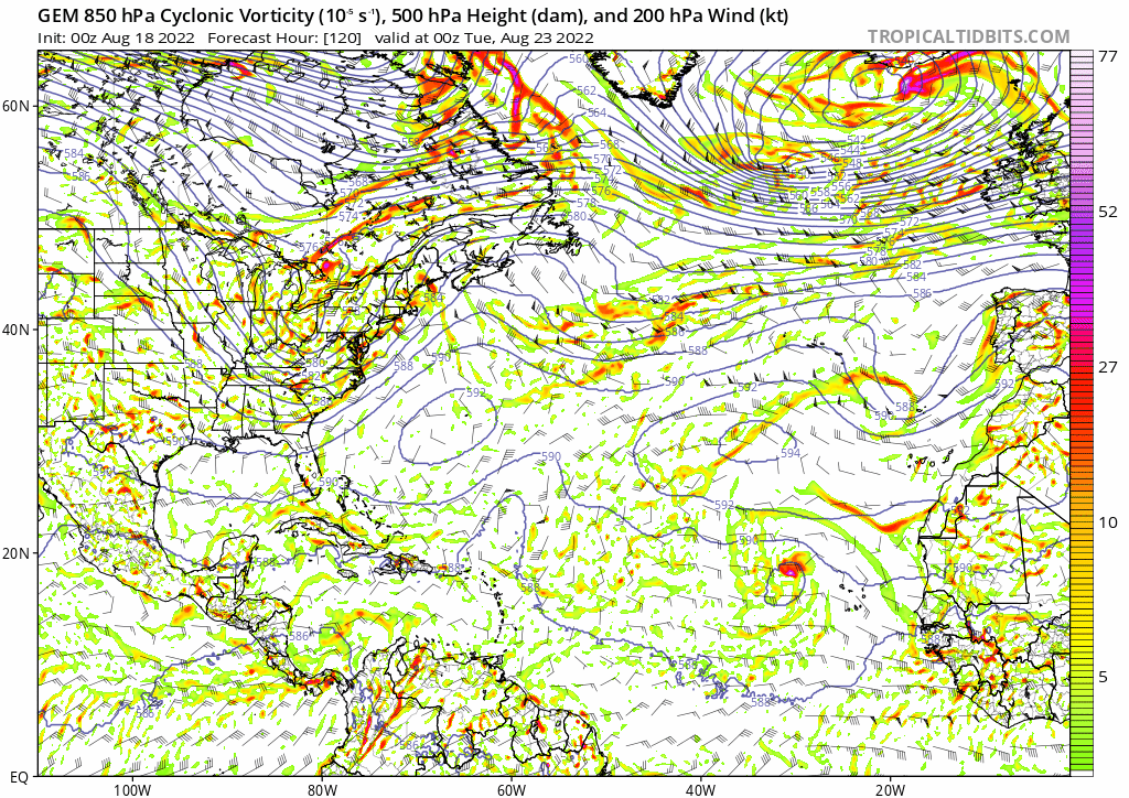
Gotta admit it was a little later than I expected but yea this is about to get interesting. The system in the Gulf/ Caribbean comes from the Central American Gyre and then just sits along the coast for a few days.
It only takes one...
.gif.8c8f200e67d0f2a83f3796483be57dd8.gif)
Central PA Winter 2022/2023
in Upstate New York/Pennsylvania
Posted
It will be interesting to see how it handles the next couple hours. Says there may be a burst of snow in the Susquehanna Valley.