

so_whats_happening
-
Posts
1,350 -
Joined
-
Last visited
Content Type
Profiles
Blogs
Forums
American Weather
Media Demo
Store
Gallery
Posts posted by so_whats_happening
-
-
So did we hit peak +IOD already? Let us see if we can get another resurgence of the cool anomalies to maintain the +IOD values.
-
 2
2
-
-
Latest TAO/Triton Subsurface
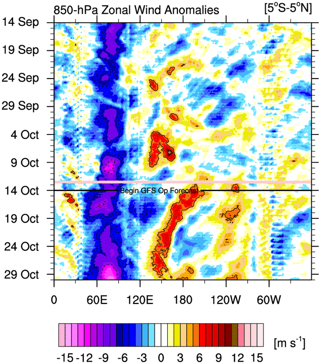
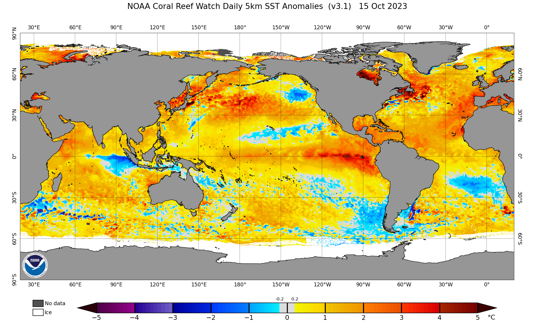
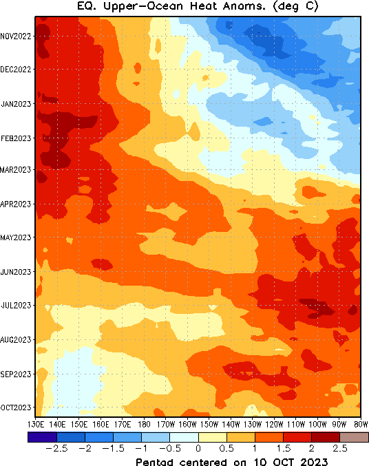
Not too much to speak of. Overall the Upper ocean anomalies have remained fairly steady now for a month. Still do believe we manage a month of near or over +2C as for trimonthly doesn't look likely as of now. Some funkiness in the VP map with minor subsidence across much of 3.4 not allowing a relaxing of the trades within that region. With the potential re-emergence of -VP over much of the IO I am curious what happens out there as we move toward November. Typically the end of +IOD is when the easterlies are disrupted and moved away from the equator so something to keep an eye on as we go through time. Ill wait to see how the models handle that secondary WWB near the dateline in the first week of November. This motion in -VP and overall funky displacement may mean we have a moving but low amplitude MJO wave into 2-3 as we move into November, we should finish up in 8 through October and maybe land in 1 to start the month.
.thumb.gif.3c3c36e82fde89ab60d266bca8db7b39.gif)

-
17 minutes ago, ORH_wxman said:
The only time we had MJO forcing in the 8/1/2 regions last season was the second and third weeks of March.
Yea if I remember correctly things hit a wall around 6/7.
-
I wonder what the resulting responses will be when the trimonthly is attained. Lol one can only guess at this point. I think regardless of peak temp the idea is well laid out again barring some major shake-up in subsurface.
-
3
-
-
1 hour ago, Terpeast said:
Interesting, any diagrams you could share here?
I thought I might have seen something that alluded to this, but I'm atrociously forgetful when it comes to links
This one maybe?
-
 3
3
-
-
1 hour ago, mitchnick said:
I should have added, there are apparently 3 models that make of the average shown. The F2 model is the warm one while the F2-3Var is much cooler. Unfortunately, the 3rd model Fsii isn't available on the site. The point is, I believe the mean is skewed by F2.


Happen to have a site for this? I don't typically look at computer models for this type of stuff except what gets posted.
-
12 minutes ago, Terpeast said:
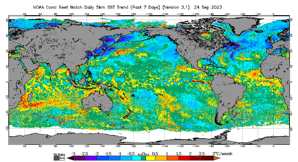
Trending in the right direction the past 15 days. Still negative, but not extremely so. Upcoming rex block N of Hawaii should help continue this trend
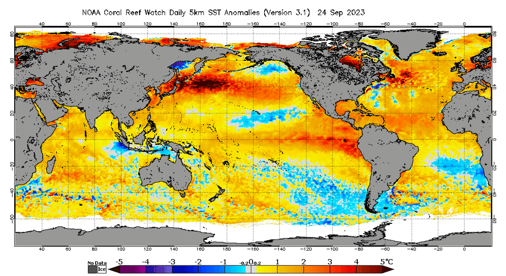
Yes with the more consistent Nino-like atmosphere it is seemingly staying that way, I hope we continue this as we move forward. The cooling along the SA coastline should also be noted as this now pushes to a basin-wide Nino. The IO should be interesting to watch coming up here too. The trades are even stronger in due time from about 70E to about the East African coastline which may induce some warming of the cold anomalies around Sumatra and cooling in the western IO in time.
-
1
-
-
20 minutes ago, GaWx said:
Every month of June-Oct have had a +PNA despite the very strong -PDO during the same period. Are there any implications?
During that time we have also had very warm SST anomalies in the B.C./ Gulf of Alaska region this has definitely helped in allowing a more ridge potential to occur with a +PNA pattern despite having a very -PDO. We saw last year from June-October 2022 we also had quite a bit of +PNA and ridging occur. We switched quite dramatically in November though as cold water re-emerged in 3 and 1+2 and waters cooled dramatically off the B.C. to Alaska area and well we know how the rest went. As long as we do not see major cooling in that region and no major cooling in Nino regions 3, 1+2 it should stay even with a -PDO as is. The image showed a 'normal' region along much of that area with warmer anomalies more west I would want those along the coast line to help support a +PNA look continually otherwise it wavers back and forth and certainly do not wish those waters to cool as that will just guarantee a -PNA pattern to exist.
-
2
-
-
5 hours ago, mitchnick said:
Jamstec updated October forecast out. Snowman19, you'll need some time alone in a locked room with its absurd SSTA forecast. Here are the DJF maps for SSTA, surface temps and precip. Link to all info here: https://www.jamstec.go.jp/aplinfo/sintexf/e/seasonal/outlook.html


The more important aspects are the -PDO is still intact definitely taken a hit but still negative. Definitely will be a solid back and forth year for overall PNA with that kind of look along the west coast to Alaska. The +IOD is still there again weakened but still there we have a much more basin wide look overall for a trimonthly average around January.
We are not too far off from these values currently the only thing different would be the continued cooling of 1+2 with time and a slow warming of 3.4 over time. I do believe we will see a +2 month sometime soon for 3.4 but i do not see continuation of that temp for many months just a slow demise the subsurface waters are just not there to keep it sustained for that long. Again this being that we don't see another massive KW as past events have shown to happen around this time of year.
We have about 2 more weeks until November lets see how the end of the month progresses should get a much better idea of impacts to come.
-
1
-
1
-
-
1 hour ago, 40/70 Benchmark said:
What is the site for these historic subsurface plots?
https://ds.data.jma.go.jp/gmd/tcc/tcc/products/elnino/ocean/t-eq_tcc.html
Goes back to 1950 always defaults to the latest plot in the beginning
Edit: guess it is now to 1947.
-
2
-
-
10 minutes ago, Typhoon Tip said:
I wonder when it will be said, '...the writing was on the wall ...' with regard to when this El Nino peaked.
I've always wondered if the actual global mechanics for this warm ENSO event were being partially confused (assumed to be more) with what is really an "elasticity" in the planetary system.
We suppressed, thermally, for 4 years or whatever anomaly that NINA mode unrelentingly carried on ...then, La Nina ends. There's a kind of over compensation in the other direction as the system wholesale got momentum that overshot the real resting point. That overshot casts the allusion of it being a harder right into El Nino, but it was really just about a correction going on. Now, the correction settles off, exposing a more moderately warm ENSO - buried inside a pepperRONI pizza with multiple toppings notwithstanding
Anyway, when the dust settles from the (hypothetical) compensation idea, the remains of the "real" El Nino is left exposed as more of a moderate in the relative sense.
I like the thought makes sense, do you have thoughts on progression after this was this a one bump deal or could we get another bump next year?
-
13 minutes ago, Terpeast said:
As far as the missing cold subsurface in the WPAC, maybe that's not a bad thing? It could indicate a multi-year nino instead of a one-time blast before a return to la nina conditions.
Your guess is as good as mine.
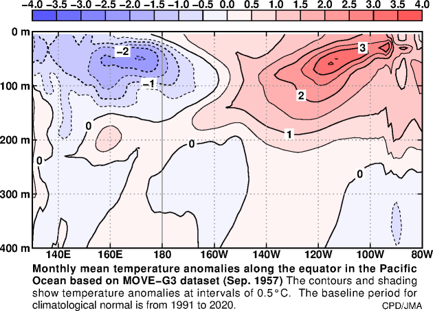
So multi year Ninos were 1957-58 & 58-59, 68-69 & 69-70 (didn't want to include this one because it was low end moderate at it's peak), 76-77 & 77-78 (weak Nino overall but also had a cool surface in the WPAC), 86-87 & 87-88, and lastly 2014-16. Of course unfortunately there is not one matching this overall evolution but again a big missing ingredient is the much cooler waters in the WPAC.
I did have that in mind for quite some time of a multi year Nino thought it would be like these past situations where the first year was mehh and the second year was much more pronounced again only year that was opposite of that progression and was stronger initially and weaker second round was 57-58.
Certainly has been an interesting go about thus far and should be interesting to watch for October- December. We should have a solid feel of how this will progress further I feel by the end of the month. Let see how the ocean reacts to this WWB west of the date line and the weakening of trades across the other regions.
https://ds.data.jma.go.jp/gmd/tcc/tcc/products/elnino/ocean/t-eq_tcc.html
-
1
-
-
Unfortunately there are not many sub surface matches as a strong or moderate El Nino to what is occurring right now of course that is to be expected. The interesting year was again 2009-10 looking almost similar in configuration with current time frame having a warmer EPAC. That year did experience a solid KW during the month of October that helped enhance the Nino from the weak/ low end moderate status to low strong. If this evolution is similar in idea we see a higher SST threshold than 2009. If we do indeed see the continued decline of 1+2 coming up here I do not think we will go negative but sub 2 and maybe 1.5 doesn't seem too far-fetched of an idea. I do believe 3.4 does push 2C for a month whether if is on a full month or between two months who knows at this point and im not sure it would matter all too much the only hope is that we do not peak early and can have solid forcing still show up through the later portion of the winter.
57-58 (strong), 63-64 (mod), 86-87 and 87-88 (hovered around mod/strong but was quite a crazy evolution), 02-03 (mod), 09-10 (strong). Most of these years were very modoki-like in SST configuration at this point in time 57-58 was the only year that had a warmer EPAC subsurface but had a much cooler WPAC. The evolution not quite the same but certainly was a notable progression from this image on. This was also a late peak year and seemingly is following pretty close ONI wise.
By far the biggest aspect we are missing is the cooler waters near the WPAC in either surface or subsurface it definitely is trying to say the least.
.gif.e0319cf8f2e8c1850d9592552beb6ffc.gif)
-
1
-
2
-
-
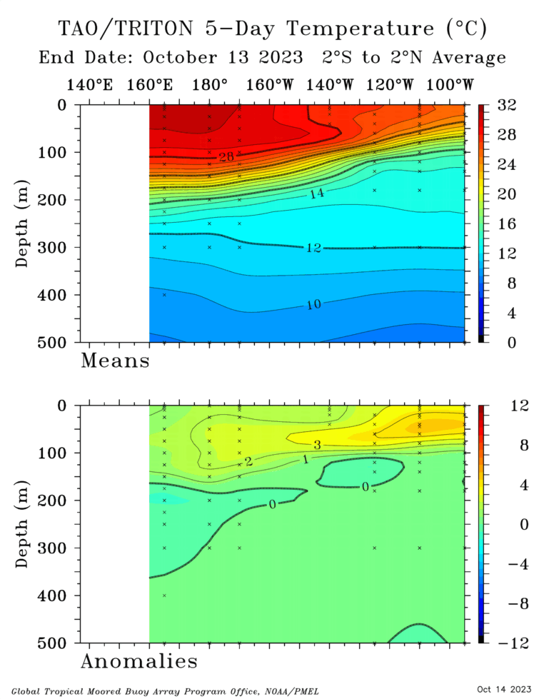
Latest subsurface change since the end of September there has been quite the push on the thermocline in the last week. I do not think it breaks but should be fun to watch as the subsurface warmth slowly is losing ground. Areas further west though definitely a different story, that warm pool is not going away and even expanded. Some +2C breaking the surface around 170-180W which is helping aid in the warming of 3.4 and definitely 4. There has been this rather consistent +VP placement around 120-150W not sure what to think about that yet.
.thumb.gif.18213d44a1f9fdfe949ebc05f0f2c3ad.gif)

-
2
-
1
-
-
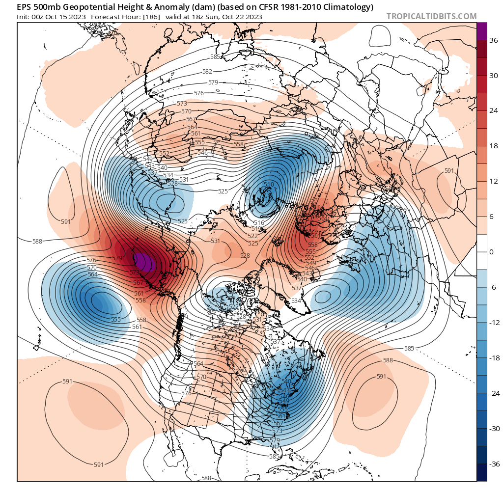
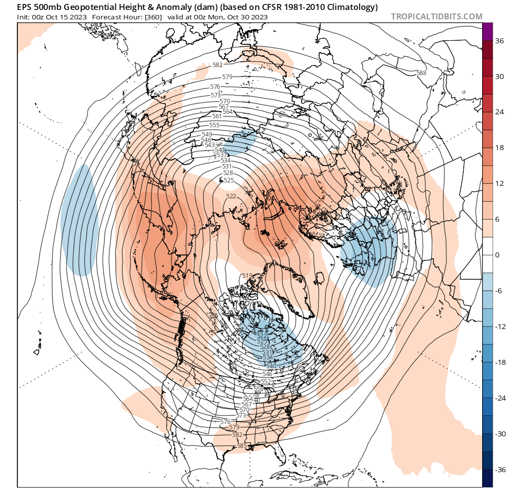
On 10/15/2023 at 4:07 PM, Terpeast said:
Ensembles showing a transitory -pna the last week of october, starting with a building ridge over aleutians/alaska.
But what’s interesting is support for a rex block in the north pac, with a low/trough replacing that stubborn nina-like ridge north/NW of hawaii.
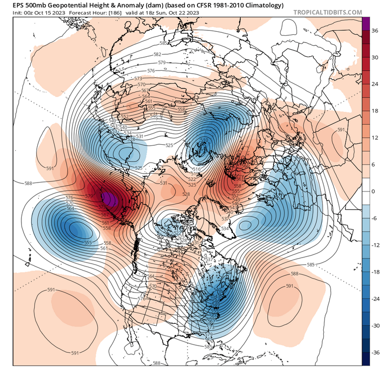
Longer range shows additional ridging over the aleutians and west thereof, with continued troughing NW of hawaii. Will be interesting to see how the PDO evolves, and I’m thinking much less negative than it is now.

This should help with getting a more consistent look of an Aleutian low while waters off Japan are still cooling they are cooling much less than it has been, long ways to go it seems for destroying the -PDO but we should see a nice tick down for the monthly number.


-
2
-
-
-
7 hours ago, bluewave said:
May be the first time the subsurface cooled so much under 1+2 and increased under 4 this time of year. No real oceanic kelvin waves to speak of just sloshing back and forth. So this year continues to do its own thing.
Yea the ever persistent subsurface warmth under 4 is surprising for a Nino year typically this area and just west would have cooled down by now. 1+2 does continue to cool more slowly as of now but there does seem to be less overall heat to work with then just a few months ago. As for the Kelvin wave it did look like at one point there was going to be one (minor event around 10/7-10/9 time frame) but that doesn't quite seem to be happening given that we have had a couple days to watch and see if something were to evolve. Will wait a few more days to see if there is any downwelling that shows up more so than what the animation shows, which was again a minor move of 28C waters in depth and the dispersion of the cool anomalies around 150W.
-
1
-
-
1 hour ago, Terpeast said:
New 3.4 daily peak at +1.72
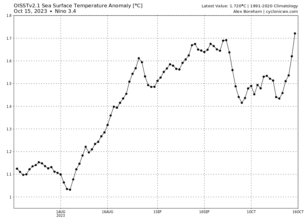
I took out the 11th as it was rather erroneous and used the latter portion of the data on the 13th as it matched much better for progression of what it looked like under the surface.
Gonna be an interesting 2 weeks here.
.thumb.gif.374c41829ccd0cc1c0b8b99998252dea.gif)
-
19 hours ago, Itryatgolf70 said:
Imo, if you go to sst anomalies at tropical tidbits website, it will give you a more accurate representation of the current regions numbers every 6 hours. That's what I use and have found it pretty good https://www.tropicaltidbits.com/analysis/ocean/
Unfortunately CDAS tends to be a little too cool in Nino regions where as CRW tends to be rather warm. OISST is probably the closest you will find to getting near what is reported by NOAA, which they use ERSST data.
-
It looks as though we have had a bit of a glitch in TAO data over the last 3 days. Keep getting fixes in the subsurface from when the data originally hits. Take for example yesterday two completely different looks from about 120W to 180. With the look resembling more along the lines of what happened on Oct 9th I may exclude the 11th from future animations unless we see a stark change occur. I had a feeling there were minor adjustments taking place from when data initially was released but this is quite the change up in the same day.
BTW the top one is the current look.
.thumb.gif.1901c66a913760c1a301c1db4368df7f.gif)

-
1
-
1
-
-
20 hours ago, Terpeast said:
Too soon to call a peak with a new KW in the subsurface, and if we stay above 1.5 through most of the remaining 2 weeks of October, we'll likely end up with a 1.5 ASO value for ONI. Where it goes after that is anyone's guess.
Either we have an early ASO peak at 1.5 (low end strong), or we have a later peak at around 1.6-1.8.
Yea I don't think at this point anyone expects it to peak in Sept, now it will be very interesting to see what happens in the next month as the subsurface warm pools are being hit quite a bit. This type of atmospheric response should produce something of note as we close out the month into November. Again not quite sure what a west propagating WWB event will produce as typically you would want an east propgating event like we saw back in August. Will this just deepen the warm pool in the WPAC again or will this push over some more anomalous waters allowing the 3/3.4 region to warm more? Honestly not to sure of what the outcome will be so it should be fun to watch the evolution.
.thumb.gif.aca830a915e61ea59f231f0181a08e2d.gif)
-
Latest subsurface look little interesting here
.thumb.gif.27817f8d7ea9e209253e755186cc843d.gif)
-
1
-
-
Not a bad forecast and generally agree. He has showed us tidbits throughout the summer so it shouldn't come as a big surprise to folks what the final outlook was. I wanna see how the rest of this month shakes out, I don't do seasonal forecasts, but like the idea of the overall temp trends that will happen this month to being how winter goes. Warm start of the month equal to a rather warm December, to a mild and more tame temp profile mid month eqaul to January and potentially cold latter third of the month eqaul to a cold February. Precip probably a bit too variable to know for certain for me at least.
-
13 minutes ago, brooklynwx99 said:
same. I think I went with +1.7-1.9 a few weeks ago which is proving to be too aggressive. thinking +1.5-1.7 now. almost no way we see even one trimonthly period at +2.0 at this point
I will hold my thoughts to what we have on the prediction thread. I still think we see a nice surge in monthly values to come here as there is no immediate sign of cooling taking place as we typically see in a Nino. This has been a fun one to watch regardless of outcome.

.gif.70d1f995baf9817529c88bb3b3f582f3.gif)

.gif.8ff19c60d971549e25e601aaca74ca33.gif)
.gif.1f59c2870eb8e276711386a77af75b50.gif)
.gif.e6a33b860d33f91382a8c4becfb9d2dc.gif)
.gif.bc30eceb9fb0bb961bf5720d777c8781.gif)


.gif.fc5bc47cbbe4d039815f97b810e22e08.gif)
El Nino 2023-2024
in Weather Forecasting and Discussion
Posted
Yea Im still not sure what to make of the IOD for our area I have found it rather irrelevant but in the indo-pacific and Africa region definitely an instrument that needs to be watched for them. Definitely feels like a byproduct of Nina/Nino development but not everyone follows similarly in path so...
As for daily PDO this is the only site I know that posts it for daily. https://s2s.worldclimateservice.com/climatepanel/
On the top right you can see a quick glimpse of several charts that are highlighted.