

Daniel Boone
-
Posts
2,098 -
Joined
-
Last visited
Content Type
Profiles
Blogs
Forums
American Weather
Media Demo
Store
Gallery
Posts posted by Daniel Boone
-
-
Seasonal Total of 6.8" here.
-
1.8" Total here. The band's after 9 p.m. missed or dissipated b4 reaching here. Portions of the County received 3 inches.
-
 1
1
-
-
Close to a half inch now and moderate snow . 31 now. What's going on with KMRX ? IN light of recent radar trends you'd think wwa would be hoisted .
-
1
-
-
1/4" and moderate snow now. 32 deg.
-
2
-
-
Putting it down here now. All snow.
-
1
-
-
Rain snow mix began here around 2 p.m..with the ambient temperature 38. Apparent steep T rates. Precip has stopped for now .
-
Many are touting the advertised strengthening polar vortex at HL will bring an extended mild pattern soon. IF this does happen, odds do favor that as most know but, not guarantee it. A strong -EPO and - NAO can sure mitigate any super resultant +AO mild pattern. Of course, even if those drivers are in place the IOD and MJO may either assist the +AO or the other drivers, depending on mode or phase. So, although the possibility of a mild last half of December appears rather likely attm. there is still some hope. Just a few uplifting thoughts for the snowlovers on here.
-
2
-
-
Nam 3k , cmc and rgem still look good. Canadians bring the bacon.
-
1
-
-
52 minutes ago, Holston_River_Rambler said:
Snowfall looks pretty realistic on the 6z Euro:
But the RGEM has won a few battles with storm evolution in the past.
I think it is now kind of a watch and see now, but then again, I'm sure I'll be looking at the SREFs in 45 min. lol
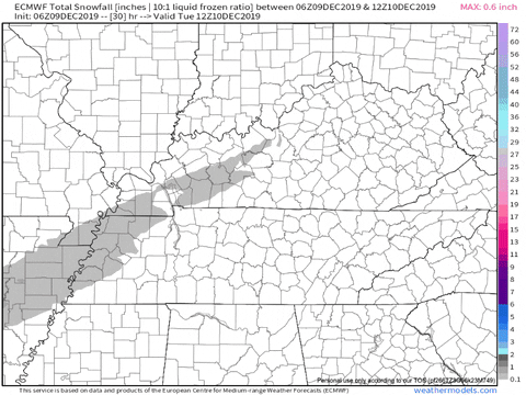
Latest Euro a downer, for sure. One thing it does have a bit of a problem with is micro precision. As far as the great Valley, it forecasts as if it runs due NE all the way into SWVA . The Valley takes more of an ENE turn once you get to Morristown/ Rogersville TN area.
-
February 2015 was fabulous here as most know, with close to 40 inches falling in just over a 3 week span.
The +TNH pattern along with one l.p. after another hooking with the +NAO was remarkable. The constant succession of Lps tracking up thru eastern Canada acted t in a way that kept the +NAO from behaving as usual in the they pulled the air southward from it instead of underneath and eastward.
-
Don't know if this had been mentioned yet (probably has) but, DT has his final Winter Outlook out now. Nice write-up. He is going cold/snowy for the Central and Eastern U.S..
Link is on his Twitter "dtvaweatherman".
-
Totalled 1.3 inches from event.
-
1
-
-
Measured an inch on hard surfaces such as snowboard and Vehicle. Heavy dusting on grass although lying leaves had a decent coating.
-
1
-
 1
1
-
-
Picked up 3.03" Total Rainfall from this system. Quite a soaking. Some minor flooding .
-
Most times models underdo nw Flow snowfall amounts. Particularly Se, Ky and portions of Lee, Wise and Dickenson Counties in Va.. It is these areas that get first "pick" at the lake and wrap around residual moisture. I don't know if this is incorporated in the model's, If not, it should be . Not just elevation.
Model's are only as good as what's programmed into or how accurate the data is going into them.
-
3
-
-
20 hours ago, John1122 said:
I mentioned earlier that I was going to write a little about what I remember and some observations about the February 1996 monster winter storm and Arctic outbreak that capped off winter. The Blizzard of 96 gets more headlines, but this event was much more significant for most of our region.
We all felt the frigid cold. Far western areas like Memphis to Dyersburg to NE Arkansas had the least precip, as there was a sharp cutoff between Memphis and Oxford. Batesville Northeast into the eastern 3/4ths of Tennessee, and Northern Alabama saw major league severe winter weather. Far southeast areas from Chattanooga east were warmed nosed and missed on the massive winter precip but still had moderate wintery precip and got extremely cold as well.
The stage was set with fresh Arctic cold a few days before the storm. The storm formed on an Arctic front in South Texas. Areas far south such as Jackson and Monroe began seeing frozen precip on Thursday the first. It began spreading NE into the surface cold as Thursday progressed. 850 temps were around 50 while surface temps were in the 20s and low 30s across Northern Miss, North and NW Alabama and Southern Tennessee. Sleet and freezing rain fell over Memphis but extremely heavy freezing rain developed around Oxford and worked it's way into Middle Tennesee. Nashville saw sleet and ZR, as did Huntsville, Alabama.
Temperatures that Thursday stayed in the 20s from just North of Chattanooga to the Tri Cities in East Tennessee. I was working in Jefferson County that day. I remember riding to work and the winter storm warnings started rolling in over the radio.
By Thursday at around 5pm-7pm snow had over spread most of Middle and East Tennessee and Southern Kentucky except for far NE areas. Southern Middle was sleet and snow mixed. Mississippi was under a state of emergency with 1-2 inches of solid ice. Northern Alabama was getting there slowly with freezing rain that would soon mix with sleet. By 9pm Thursday heavy snow was falling from Nashville to Knoxville. This would continue over northern Miss. Northern Alabama, southern Middle and East Tennessee into SWVA for the next 12-18 hours.
There was thundersnow and thunder sleet across the south. Temperatures fell rapidly with the slow and ice happening with surface temps in the upper 10s and low 20s. Fayetteville in Southern Middle had freezing rain to sleet to snow with a temp range of 26 falling to 19 during the event. At midnight Crossville had heavy snow and 19, Nashville snow and 20, Tri Cities heavy snow and 20, Knoxville heavy snow and 23. Chattanooga had been stuck at 33 with rain but they transitioned to ice then sleet and finally to snow. With 3 inches of snowfall on top of ice during the event.
Extremely heavy snow developed in small area of Roane, Northern Knox, southern Anderson, Union and Jefferson County. This boosted their totals to all time type snowfall records.
At the end of the precip Northern Mississippi saw 3 inches of solid ice/snow. Northern Alabama had similar totals with slightly less ice and a bit more snow. Southern Middle Tennessee had 1 inch of ice and 4-5 inches of snow. Nashville had 5 inches of snow on top of ice. Cookeville had 6 inches of snow on top of ice. The western Plateau areas saw 11-14 inches of snow. Southern Kentucky saw 7-10 inches. The Eastern Plateau areas such as Oneida, Lafollette and Cumberland Gap saw 14-17 inches of snow. The Northeastern Valley from Morristown NE into SWVA saw 13-17 inches of snow. The areas from Rockwood to Halls to Maynardville where the enhanced thundersnow went on picked up 18-22 inches of snow. For whatever reason, Tyson only recorded 8 inches from the event.
Specific snowfall reports I witnessed or have found from various NWS sites.
Nashville 5 inches.
Cookeville 6 inches.
Huntsville, Ala 3 inches - lots of ice.
Batesville Miss 3.2 inches + ice.
Chattanooga 3 inches + ice.
Knoxville Tys 8 inches.
Rockwood reported 8.5 inches on .82 precip, data missing for the next day with 1.09 precip falling. Likely 20 inches in Rockwood.
Lenoir City 9 inches.
LaFollette 17 inches (observed this myself)
Norris 18 inches. (Observed this myself.)
Maynardville 21 inches. (co-worker lived there.)
Halls 19 inches. (Maynardville co-worker observed)
Crossville 13 inches.
Jamestown 13 inches.
Fayetteville 4 inches - lots of ice.
Tazewell, Tn 15 inches.
Greenville, Tn 11 inches.
Bristol, Tn 13 inches.
Kingsport 14 inches.
Abington, Va 16 inches.
Middlesboro, Ky 10 inches.
Corbin, Ky 9 inches.
Knoxville Exp Station 2.08, all frozen, missing data. Likely 18+ inches of snow.
So generally most of the area saw frozen, a good bit of it had double digit snowfall totals that rivaled the Bizzard of 1993.
The cold that followed was record setting for February. The air mass produced Minnesota's all time record low of -60. Temperatures here were widespread below 0. The very few areas that stayed above zero in far southern areas had lows in 1-3 range. Most areas with snowpack were at least -10 with quite a few -20 or colder readings. It was -20 imby, -20 in Spara, -22 in Tazewell, -23 at the Greenville experimental station. It was -16 in Crossville, Norris and Kingsport and -10 to -15 from Murfreesboro to Northern Knoxville to Morristown. High temps were in the upper single digits across Northern areas from Tazewell west to Dyersburg. Only around 10-12 in many others. As far south as Huntsville the high temp was only 13 in the wake of the storm. Mt LeConte didn't have notably different temperatures than the rest of the area, it was actually slightly warmer February 5th than other areas. -17 was as cold as it got.
After looking back on it, this may be the most impressive winter event of my lifetime. Virtually as cold as 1985 with snowfall amounts rivaling the bizzard of 1993, plus a massive ice event for west and SW valley areas.
I lived and worked in Pennington gap in Lee County at the time and remember this well. I also recorded the event in my daily weather log.
My records from then were unfortunately lost during relocation. However, memory serves me quite well.
Snow began in Pennington around 8:30 p.m. and quickly became heavy. By 6:30 the next morning there was 6 inches with just a few flakes falling. I worked for the city at the time and was outside throughout the day and only observed a few light flurries and can recall reports of heavy snow just to our south in Rogersville.
Snow began falling moderate to heavy just after 4 p.m. and lasted untill 9 or so with an additional 4 inches falling for a total of 10".
The morning low there the 5th was -21 with the official afternoon high of 4 below. This was recorded at the radio station there as well as my home in Pennington gap. A report of -30 (via, WCYB) from the Rose hill area in western Lee County.
The Jan 21 1985 outbreak was about the same with -24 Low, -4 High with snow depth of 7".
-
4
-
-
Happy Thanksgiving to all !
-
4
-
-
10 hours ago, jaxjagman said:
You have to remember when you look at peoples tweets on twitter are they talking about IMBY.We live in another warp zone to where they live at,just saying.
He was talking about the advertised +AO.
-
1
-
-
Hm replied to my tweet regarding this and said he expected this to happen but, it should be short lived.
-
2
-
-
Glad youre on the mend Jeff. Great to have u back.
-
2
-
1
-
-
I see CPC IS going warm for most of the country for December. Following those climate models. Of course, cpc is warn biased anyway as most of us know.
-
Thanks buddy. Just being an old timer with experience and memories that help.
Brother, you definitely add valuable insight to the forums.
Let's hope the Ghost of those winters of yore pay a visit . Although, I couldn't enjoy them like I used to. Tough to handle the cold anymore.
-
2
-
-
Radiance, first off, kudos on the work u put into this. Good stuff !
The biggest difference this winter compared to last I believe is going to be blocking. Enough of it and you can have cold cover much of the U.S., coast to coast, including the upper Southeast even with a -PNA. Ala., 1978-79. Of course on back, the '60's featured this fairly consistent. Blocking was so strong it congested the flow to create a +PNA at times with a -PDO background .
Of course, as so many make a point of, we are in a warmer Climate era now so, things are different now. Yes, this is true but, a watered down version to the pattern those years is still possible. Also, we are in a decent Solar Minimum now and let's not forget the descending QBO.
-
4
-
-
This period coming up is going to be tough. So many variables juggling for position.
-
1
-
December/January 2019/20 Winter Speculation Thread
in Tennessee Valley
Posted
Euro depiction of PV over Alaska is not good. However, IF retrogression were to occur and drop/place it over the Aleutians then domino from that. Generally would need a strong ridge build in the AO domain for that though.
The Gefs placement of feature looks far more desirable and easier to better align a favorable 500 mb pattern.