

Daniel Boone
-
Posts
2,849 -
Joined
-
Last visited
Content Type
Profiles
Blogs
Forums
American Weather
Media Demo
Store
Gallery
Posts posted by Daniel Boone
-
-
53 minutes ago, Itryatgolf70 said:
Jax, hopefully the mjo can continue to move along and not get stuck in warm phases or stall there. I know its la niña, but trying to be optimistic.
If it weren't for the Nina, with the strong HLB we'd already be in business Winter weather wise.
Hopefully the SST'S in the western PAC will become more conducive for better and stronger MJO progression in cold Phases as we move forward this Winter.
-
 1
1
-
-
41 minutes ago, WxUSAF said:
Precise timing and orientation varies, but this s/w could produce some flurries or snow showers Saturday I’d think.

Yeah, looks potent enough for light accs up and down the Apps.
-
11 minutes ago, Holston_River_Rambler said:
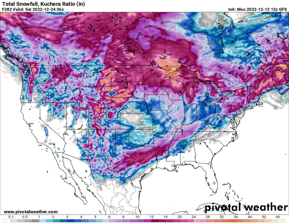
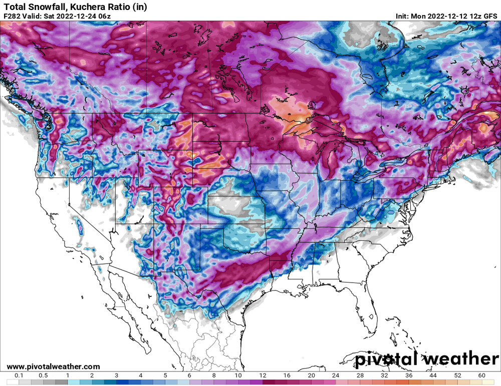
Regardless of the specific outcome, the GFS REALLY wants a big storm somewhere in our forum area around the 23rd. Seems like its been trying to show something since that period came into range.
True.
-
1
-
-
30 minutes ago, Bigbald said:
Where oh where have we seen this axis before??? Seems like the last 2 years have had this kind of banking axis against the Apps. In lala land so its probably moot but I was just struck by the familiarity.
yeah. we have a difference maker this time that hopefully will project that further east. Gfs is terrible with upstream blocking.
-
1
-
-
26 minutes ago, GaWx said:
Looking at the climo of the other eight 3rd year cold ENSO winters since the mid 1800s:
1) Winter of 1894-5: mainly Feb of 1895 (but also the last week of Dec/first few days of Jan)
2) Winter of 1917-8: Dec-Jan of 1917-18
These were two of the most historic lengthy periods on record in the SE US in terms of a combination of multiple wintry events and persistent extreme cold.
For example, Dec of 1917/Feb of 1895 are RDU's coldest Dec/Feb and ATL's 2nd coldest Dec/coldest Feb on record. Also, Feb of 1895 is the snowiest ATL month of any on record due to not just one but two major snowstorms along with a third one! In addition, ATL had two major winter storms in Dec-Jan 1917-8.
But I'm not just talking about well inland/northerly locations like RDU and ATL. I'm also talking about locations not at all accustomed to this that are far to the south, including right on the Gulf and SE coasts. N.O, had a historically very heavy snow in Feb of 1895.
Right here Feb of 1895 was both the coldest Feb on record and it gave a very rare ~2" of snow (that much accumulation has occurred on average only ~once every 20-25 years). Dec-Jan of 1917-8 had not one but two accumulations. Both were 1/2" or smaller but only ~1/8 of winters have gotten ANY accumulation. Dec of 1917/Feb of 1895 were the 4th coldest Dec/coldest Feb on record here.Even though im not in the SE area, thats some interesting stuff Larry and still relates to our adjacent areas.
-
 1
1
-
-
2 hours ago, Carvers Gap said:
We need a strong block and a slight SER. I think we get both.
Agree. I'm feeling pretty confident. We've been burned so many times it's tough to be though.
-
16 minutes ago, Carvers Gap said:
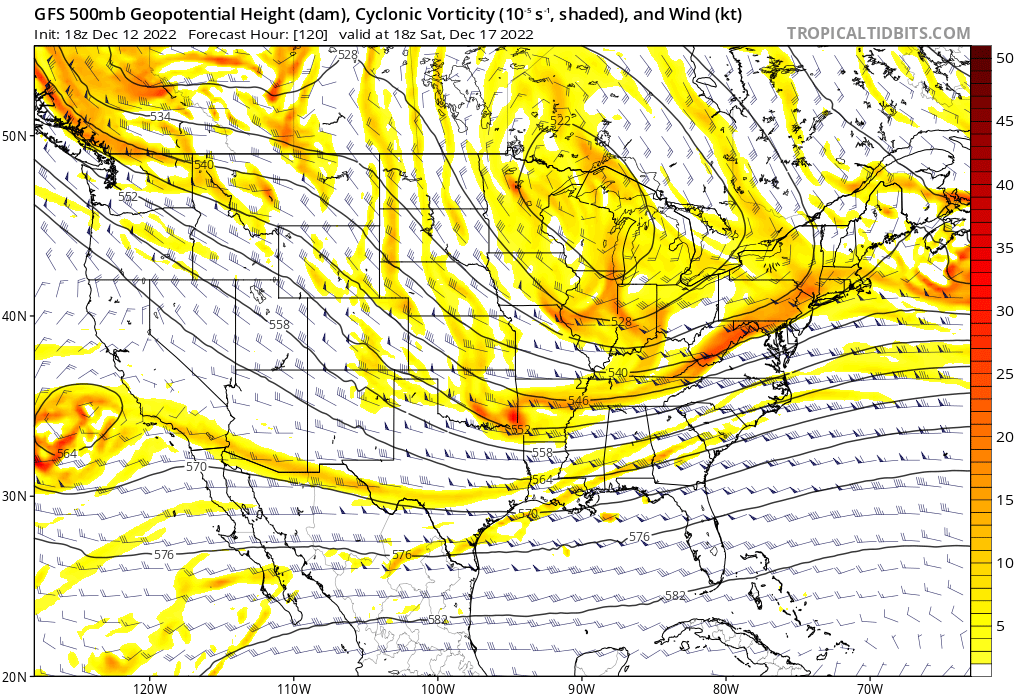
The 18z GFS is trying to turn out my power on Christmas Eve-eve. The GFS is again advertising an over-running event. No idea if I trust the model, but it has had some consistency in showing that run to run. My guess is that will shift to middle and west...but who knows with that block suppressing things.
Yeah, the block may be the difference maker here, depending on how deep the trough is out west, however. If there's a deep trough still out there it could cause the boundary to be more ene oriented and cause frozen precip to be relegated to our north and west.
Hopefully, we get a west, east boundary and the entire forum cashes in . IF there is an ene orientation, hopefully it'll be far enough south to still get the area in the frozen zone. I've witnessed that on several occasions.
-
2
-
-
1 hour ago, Carvers Gap said:
There are ingredients (just spitballing) for a multi-wave over-running event for somewhere in the forum area sometime between the 17th and Christmas. If the GEFS can be believed(huge IF), the over-running characteristic are readily apparent. The gradient sets east-west over the forum area, and then the GOM moisture runs along it. The CMC is suppressed, but it has been overdoing the cold of late. Chance are that gradient is north of where it has it. The ICON has that look. Somewhere between the great bend of the TN River in Alabama and the Ohio...there is a chance for a gradient winter storm.
Cosgrove is honking for a major snowstorm just before Christmas for the Apps to Ohio Valley.
As some know on here, Coz has been in the business many years and is an expert in LR and Pattern recognition. He, imo, is an ef hutton of Meteorology.
-
3
-
-
42 minutes ago, Icy Hot said:
I'm on the app in Chrome on a Android phone. None of these ads were here last year but now every page of posts is flooded by ads.
It's acting as if ur not signed in then.
-
1
-
-
GFS just spits out any solution there is under the Sun from run to run. "Upgrade"? More like, Downgrade.
-
1
-
-
1 hour ago, Itryatgolf70 said:
I don't think they should have upgraded the gfs. It seems that It was doing better then than now imo
It was.
-
1 hour ago, John1122 said:
We will see where it goes, but I wouldn't give a lot of credence to the GFS right now. One run its a snowstorm. One run its a heatwave. The 12z had us in the upper 10s and low 20s 1am Christmas morning. The 18z has temps in the mid 60s at 1am Christmas morning.
I don't think I've ever seen a model perform so wildly with basically every run.
Its become complete utter junk, imo. It just shows any possible outcome run to run.
-
1
-
-
1 minute ago, Carvers Gap said:
At minimum, an upslope NW flow event looks on tap for next weekend. I am definitely watching that slp pop just to our SE. Something to watch. Dare we say the pattern is almost in reach?
Yeah, should be at least a couple synoptic snow events the last half of the Month along with upslope events as well if the projected 500 pattern comes to fruition.
-
1
-
-
6 minutes ago, Carvers Gap said:
That was good discussion by you all. I haven't read that article yet. Normally, the GFS has had some predictable tendencies...too cold in the long range, too progressive with storms along the coast inside day 7, too quick to break down HL blocks. Once one factored all of that in, it was usable. What it is doing right now just doesn't seem usable - not predictable and erratic. I was almost wondering if it was handling the MJO regions poorly or just not getting SSTs correctly. I thought I someone note that the jet was being handled differently by it as well. It did get right the push back of the pattern change, so I hate to discount it completely. It is almost like it is overdoing the heat at the mid latitudes, and giving the jet too much strength as a result.
Yeah, the latest "upgrade" appears to really fouled some things up.
For one, they over compensated for it's " cold bias". Apparently didn't do anything irt how it doesn't work well with blocking. Other things they've tampered with appear to be evident as well.
-
4
-
-
17 minutes ago, Holston_River_Rambler said:
Someone in the MA forum linked to this today. Some good insights into how the CPC folks see the pattern evolving:
https://www.cpc.ncep.noaa.gov/products/predictions/WK34/
For me, it was striking how much came down to La Nina probabilities. Not saying they are wrong to do that, but the whole write up was fascinating in terms of trying to see how the pros reason through medium to long range forecasting.
Some good MJO disco in there too.
Yeah, enso is heavily weighted by them.
-
3
-
-
12 minutes ago, John1122 said:
It may not produce but it's hard to ask for a better looking pattern than what we have on tap beginning about a week from today. Christmas won't be spent at the grill, flipping burgers and wearing shorts to say the least according to the EPS.
You got that right Buddy. Looks promising for much of the area having a white Christmas actually.
-
1
-
-
1 minute ago, PowellVolz said:
While that season was epic for ETn, it was extremely frustrating for Knoxville. We where probably 15 miles SW of the “all snow” line. That being said… it was one of the most active winters of my life time. I’m 48 so I’ve seen some really good events but not many very good winters. My dad use to talk about the 50’s and 60’s where we would have snows on the ground for a week at a time. Two weeks later it would snow again.
.Yeah, I remember that being the case. We were fortunate up this way. Wise in Wise County broke the State Seasonal Record that year; 123.4 inches ! I recorded 52" in Pennington gap here in Lee County ( not a record here ) .
The 60's was a snowy decade for the area. Nina, Nino, -PDO, -PNA, it didn't matter, lol
-
2
-
-
4 hours ago, Holston_River_Rambler said:
The big storm that was going to be a big front next week has almost turned into a Miller B on the 6z GFS.
The GFS depicts the low transfer from Dubuque, Iowa to Cape Fear
That is actually a probable solution with strong blocking. Even a further South track is possible but, most likely not this go around. It would be nice to finally get into a 95-95 type pattern. Several Miller B transfers of which tracked far to the South.
-
3
-
-
A little confidence builder; the 1960's featured several -PDO, -PNA, -NAO combo Winter's and they weren't too shabby Snowfall wise.
-
2
-
-
2 hours ago, Carvers Gap said:
If I lived in northwest TN right now...I would be chomping at the bit. The pattern is loaded for bear from a line from Memphis to Nashville and northwest. I hope NE TN can get in on the action (not holding my breath). A classic Nina cold weather outbreak is set for the western half of the state IMHO. I am really interested to see if that line can press further SE.
Yeah, hopefully the deep cold will come far enough east to get us on the cold side of the boundary.
-
6 hours ago, Met1985 said:
We are finally seeing the effects of the blocking and the ridge bridge over the top. The 12z GEFS was the coldest run here in the region that we have seen. The cmc is very cold for us also and all this is in the 7 to 9 day range so we are for sure moving forward.
IF the projected Pattern pans out, the CMC would be the winner at range irt the Operationals. It has constantly projected the very cold Pattern.
-
4
-
-
It's really a shame the anticipated blocking hasn't threw the Nina off kilter much. So far, about all it's done is help with the moisture transport into our area. It is possible had the Blocking not setup we'd be dry and warm with a huge SE Ridge dominating.
-
1
-
-
3 hours ago, Carvers Gap said:
I relearn this lesson every winter. Models often go haywire right before and just as cold air shows up in the medium and long range in modeling. Guessing this is a Montana special(cold) that bleeds in an ever modified form...eastward. Winter chances increase as one goes westward(from the Apps) in this set-up.
Yeah, sure looking more and more like a Plains/ Rockies Winter. It may translate East to encompass areas similar to last Winter and year before.
-
9 hours ago, John1122 said:
Just a bit of a run to run difference on the GFS. There's a 45 degree difference in our area from 18z to 00z. I don't know which, if either will be correct but right now it's just not a usable model for anything beyond 5 days. The GEFS doesn't agree with the op, at all.
The Canadian is unchanged. The cold arrives and we have snow showers around the 15th/16th.
We'll call it the Woke Hack.
-
 1
1
-
December 2022 Medium/Long Range Pattern Discussion Thread
in Tennessee Valley
Posted
Yeah, was just looking at that. Man , if that comes to fruition, white Christmas would be likely with locked in cold .