

Daniel Boone
-
Posts
2,102 -
Joined
-
Last visited
Content Type
Profiles
Blogs
Forums
American Weather
Media Demo
Store
Gallery
Posts posted by Daniel Boone
-
-
My thoughts are exactly with Carvers. That NE PAC warm pool along with HLB are fighting any Niña takeover .
IF Eps later depiction is right, it appears HLB may gradually force that vortex in the Yukon south. Probably down into south central Canada then who knows from there. Down into US or into eastern Canada.
-
 3
3
-
-
51 minutes ago, Fred Gossage said:
I'm very much not talking about the full winter. I am simply saying that, for the next few weeks, we are heading toward a pattern that would possibly favor one or more severe weather threats between now and Christmas. I honestly expect us to flip back and forth between the current pattern and the coming pattern for the rest of the winter. CFS in particular wants to take the MJO back to the Pacific during some point in January and into February. I kinda expect it to do that given what we have seen thus far. February 2011, the MJO didn't budge from the Pacific. My post had nothing to do with expectations for the winter overall. It was telling folks in this area to start paying attention to systems ejecting out of the Plains between now and Christmas.
Gotcha ! Thanks for the clarification. I expect back and forth as well. MJO does rule the roost many,( if not most, times ) tbh.
-
1 hour ago, Fred Gossage said:
MJO looks to be going toward a position a bit more typical of La Nina as we head forward, and AAM looks like it's going to start tanking soon. I would start keeping an eye on medium range guidance for one or more severe weather threats to start showing up between now and Christmas or so. No real specifics other than that, but it may be time to start having our eyes open...
Same things were brought up back in '95-96 Fred as well as 2010-11 and a couple Factors warred against the full La Niña pattern takeover . Oh yes, it did try especially in 95-96 as short lived bouts of mild would come east only to be shunted by strong blocking in the NAO domain and other areas as Carver aluded to.
Of course, Niña was weak that season so, odds are less favorable for that yo happen now and more in favor of more niña influence. However, what about 2010-11 ? Strong Niña but, remained cold overall in the East. Blocking was one reason. What was the others ?
-
1
-
-
1 hour ago, John1122 said:
From MRX.
This was pretty close to the model output, which frankly surprised me. Not sure if they're getting better or just got lucky.
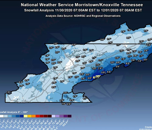
Portions of Lee County received a good bit more than those reports. Problem is, very few report from here. Rose Hill for instance received 2.5 inches . Ben hur, 2" . I took measurements. The .80 was mine at 7 a.m...another .7 fell after that.
-
2
-
 1
1
-
-
Noticed Dierks on WCYB this evening mentioned just a low chance of a turn over at the end for end of week system and showed a model run. He is a good Met and guy but, is warm biased.
-
1
-
-
Lee County totals varied from under an inch to several. Jonesville, 1 to 1.5" . Rose Hill 2.5, Ben Hur 2". Pennington gap 1.5. More on mountains, of course.
-
2
-
-
6 minutes ago, bearman said:
Starting to accumulate quickly in West Knoxville as the sun has set.
Latest update from kmrx has no accumulation for Knoxvegas. Not surprising though.
-
2
-
-
Feb. 2015 was epic and was going against the grain, so to speak.
-
17 minutes ago, BlunderStorm said:
Kingsport/Gate City seeing any action yet?
Lt rain in Kingsport still. Just leaving there geading back home. Inlaws said snowing in Jonesville.
-
1
-
1
-
-
Light snow coming down steady 1800 and up on Powell Mountain, Lee/Scott County line.
-
3
-
-
Wonder what's causing the drop off in parts of Eastern KY on Rap ? Looks rather odd.
-
1
-
-
2 minutes ago, Holston_River_Rambler said:
Yeah just about to say the 0z NAM is even further S and E with the SLP and has a band swinging towards the plateau toward 12z
That should allow for more system generated Snowfall for the area.
-
1
-
-
31 minutes ago, John1122 said:
I am surprised they issued the WWA, though they point out it's mainly above 2000 feet.
I'm not 100 percent sure the point forecast isn't generated by the NAM forecast. It shows the change over happening here at 8 am, and my point forecast says "Rain before 8am, then snow between 8 and 9am, then rain until 2PM, then snow after 2PM."
It looks NAM generated.
-
1
-
-
If today's GFS Operational comes to fruition, our cold/snow after 2morrow and Tuesdays went in the crapper! Flip flop from last several days.
-
6 minutes ago, Holston_River_Rambler said:
MRX is going with a chance of some snow mixed in tomorrow AM for my area.
"Rain and snow showers likely before 10am, then a chance of rain showers between 10am and 4pm, then a chance of rain and snow showers after 4pm. Cloudy, with a temperature falling to around 34 by 5pm. Northwest wind around 10 mph, with gusts as high as 20 mph. Chance of precipitation is 60%. Little or no snow accumulation expected."
That's a rather "cheesy " looking forecast. They can do better than that.
-
7 hours ago, jaxjagman said:
I swear this has typical strong NINA sig all over it,we get the early cold and we will bake around X-Mas onwards.Nice cold spell tho in the long range showing up.
ECMWF Deterministic FORECAST FOR: BNA    LAT=  36.12 LON=  -86.68 ELE=   591

                                            00Z NOV29
                 2 M     2 M     2 M     SFC     SFC    6 HR    FROZN   TOTAL
                 MXT     MNT     TMP     DEW     WIND    QPF     PCP    CLOUD
                 (F)     (F)     (F)     (F)    (KTS)   (IN)    (IN)    (PCT)
SUN 00Z 29-NOV                  44.9    35.9    01005                     72
SUN 06Z 29-NOV  45.0    37.4    39.4    34.2    05003                     98
SUN 12Z 29-NOV  39.7    36.6    37.1    34.8    11003   0.00    0.00      99
SUN 18Z 29-NOV  56.2    37.0    56.5    43.3    18004   0.00    0.00     100
MON 00Z 30-NOV  57.6    50.5    50.4    50.0    35004   0.17    0.00     100
MON 06Z 30-NOV  50.4    41.9    41.8    41.5    34012   0.51    0.00     100
MON 12Z 30-NOV  41.8    36.5    38.9    38.4    31011   0.49    0.03     100
MON 18Z 30-NOV  39.0    35.5    35.7    24.6    30011   0.02    0.00     100
TUE 00Z 01-DEC  35.7    32.9    32.8    22.8    31009   0.02    0.02      94
TUE 06Z 01-DEC  32.9    28.7    28.6    19.1    30006   0.02    0.02      25
TUE 12Z 01-DEC  28.5    25.5    25.5    19.7    27006   0.00    0.00       2
TUE 18Z 01-DEC  36.3    24.9    36.4    19.0    28007   0.00    0.00      11
WED 00Z 02-DEC  38.7    31.6    31.4    20.5    27005   0.00    0.00       0
WED 06Z 02-DEC  31.5    26.0    25.9    19.8    27004   0.00    0.00       0
WED 12Z 02-DEC  27.4    24.7    25.0    21.3    24002   0.00    0.00      30
WED 18Z 02-DEC  44.7    24.4    45.0    25.7    30001   0.00    0.00      35
THU 00Z 03-DEC  46.8    36.6    36.1    29.8    10004   0.00    0.00       0
THU 06Z 03-DEC  36.1    27.8    27.9    23.7    15002   0.00    0.00     100
THU 12Z 03-DEC  30.5    27.4    28.4    24.4    11004   0.00    0.00      69
THU 18Z 03-DEC  50.7    28.4    51.0    29.3    17003   0.00    0.00      33
FRI 00Z 04-DEC  53.0    44.4    44.7    35.0    18004   0.01    0.00      95
FRI 06Z 04-DEC  46.5    43.0    43.3    40.9    20005   0.04    0.00     100
FRI 12Z 04-DEC  43.4    42.6    42.7    42.5    17002   0.20    0.00     100
FRI 18Z 04-DEC  44.8    42.7    44.8    43.9    24001   0.24    0.00     100
SAT 00Z 05-DEC  45.8    43.8    43.7    42.4    36003   0.02    0.00      98
SAT 06Z 05-DEC  43.7    39.9    39.8    36.8    35007   0.00    0.00      94
SAT 12Z 05-DEC  39.8    35.9    35.9    32.7    35007   0.00    0.00      86
SAT 18Z 05-DEC  45.8    34.7    46.0    30.4    33008   0.00    0.00       0
SUN 00Z 06-DEC  47.9    39.6    39.4    30.7    33006   0.00    0.00       0
SUN 06Z 06-DEC  39.4    32.7    32.4    29.8    30004   0.00    0.00       0
SUN 12Z 06-DEC  32.4    30.2    31.1    28.9    22004   0.00    0.00       0
SUN 18Z 06-DEC  50.9    31.1    51.1    34.1    28007   0.00    0.00       0
MON 00Z 07-DEC  52.8    43.4    43.3    34.1    27007   0.00    0.00       0
MON 06Z 07-DEC  43.3    40.3    40.2    33.3    32008   0.00    0.00      40
MON 12Z 07-DEC  40.2    34.5    34.5    23.0    32008   0.00    0.00      46
MON 18Z 07-DEC  37.9    33.5    37.9    19.3    33010   0.00    0.00      16
TUE 00Z 08-DEC  38.4    31.4    31.2    16.0    34006   0.00    0.00       0
TUE 06Z 08-DEC  31.2    25.4    25.3    17.7    33003   0.00    0.00       0
TUE 12Z 08-DEC  26.1    22.9    22.9    17.5    24003   0.00    0.00       0
TUE 18Z 08-DEC  37.4    22.8    37.6    15.2    19002   0.00    0.00      81
WED 00Z 09-DEC  38.3    32.8    33.4    20.2    16005   0.00    0.00       5


Yeah, however, there are  a couple drivers that may change the typical Nina pattern. The NPAC SST's,and the NAO . Of course we all know about 95-96 and 10-11.
Early on those years the same thing was touted. La Niña pattern will take over and we go mild.
Odds ,as we all know, do favor the stereotypical Niña and pretty strong at that but, there is some hope; a couple things that can war against that.
Just some encouraging thoughts for the cold snow lovers.
Y
-
1 hour ago, Carvers Gap said:
Will try to save this. This is the 90hr GFS 500 map. When we look back on this thread, this is the set-up. Looks like the crazy type of block(which has been forecast and not come to fruition during past winters), might actually verify.

What a boobyful Map !
-
2 hours ago, BhamParker said:
I’m hugging the RGEM. MRX saying 1-2 for elevations between 2000-3000 feet and that seems a little conservative to me after seeing the RGEM, Euro, and GFS. Even the 18z NAM seemed to have some nice totals even around gatlinburg.
They're pretty much always conservative. I'll say this, IF there's strong nw flow off the lakes and enuff steep lapse rates, I guarantee much more than they're showing. NW flow alone would yield more than 2 inches in places like Wise, Va for example..
-
1
-
-
38 minutes ago, Carvers Gap said:
Hour 192 snow accumulations on the CMC at Tropical Tidbits. This is from TWO systems...

This is the one we're rooting for Carvers. CMC actually did better here the last couple seasons than the others a few times.
-
1
-
-
2 hours ago, Carvers Gap said:
Long Range Update(at least from my perspective, and as Jeff would say, certainly open for debate!)....
In the LR, this morning's 0z EPS has moved a trough into EPO/PNA region after d12. Trough is still in the East as well, but looks like a retrograde to a ridge is underway. Interesting feature is a -NAO in conjunction with the western trough. That would actually work, and would create nation wide cold driven by cold invasion the West and spreading eastward. The problem is that -NAOs on modeling have rarely verified, and even if they do, just for a fraction of the time and strength originally modeled during recent winters.
Euro Weeklies update (from last evening) has a similar solution though this morning's 0z run is certainly more aggressive and quicker in establishing the western trough. Interesting thing to watch will be the weak AN heights over the Davis Straits which are persistent after Dec 20 and after the -NAO from Dec 10-20. Looks like there will be temporary intrusions of cold after the 20th with the base pattern for winter beginning to take hold which is a trough in the Northwest. Will it happen? Not sure. The Euro Weeklies sure missed(like totally whiffed) on this upcoming trough amplification as recently as two weeks ago. Also of note, the last 4 runs have certainly evolved into a "less hostile" look over the East after Dec 20th.. Could it be that we finally get a -NAO during winter which will mute the upcoming warm phases of the MJO? Don't bet on it...but given how winter has started with a big surprise, I wouldn't bet against it either. On the subject of the Euro, today's run of the MJO on the NCEP site loops the MJO in the null phase and certainly looks poised to head into the warm phase tour.
I would say right now that given the complete whiff by the Weeklies on the early December pattern, take it with a bit of a grain of salt. Also important to remember that the Weeklies do have a tendency to settle down and become a bit more accurate(as accurate as a 4-7 week model can be) as the winter season settles in. Of note the GEFS Extended Ensemble locks in an eastern ridge beginning around Dec. 19th and never looks back through the end of its run which is Dec 31. So, the Weeklies do have some support though LR modeling (of the variety past 3 weeks) do have a warm bias at times.
Of note the 6z GEFS nor the 0z GEPS most recent runs do not have the 0z EPS look. Both still have an eastern trough. Have to think the GEFS will flip soon as its MJO from yesterday took the warm tour. An important note is that the MJO is a bit weaker than last year west of the dateline. I definitely give some increased cred to the Canadian ensemble as it has just schooled the GEFS and EPS on the upcoming pattern. No idea what the global verification scores will look like, but it appears to have nailed the short term upcoming pattern over the SE prior to other models. The GEPS has been decent of late and will hold more weight than normal for now in my book.
Lastly, when I see a big mid-Atlantic ridge which sort of retrogrades into a WAR(western Atlantic ridge), makes me think that the SPV(polar vortex at 10mb) is going to get hammered. There is plenty of chatter about a SSW on Twitter for sure, and has been for a few days. However, the aforementioned ridges are also a great hint other than the Twittersphere. That might be why a -NAO is beginning to show up as the SPV is getting jostled around. I do think we need to be wary as the last two winters have featured lots of failed or less than advantageous PV splits and false -NAOs(after much wx model advertising). However, the start to winter for early Dec appears to feature an abrupt change in modeling (to cold) and would not surprise me to see that happen 1-2 more times for 10 day time frames.
Also, important to remember that early winter is a very tough time to score IMBY. As some have noted though, that has been the trend of late - early season snows in various micro-climates (meaning not widespread) followed by meh winters. Still, the problem is that often cold is still marginal at this latitude in early December. Hopefully, we can get some snow showers in E TN with the first system this week and maybe middle and/or west TN can grab some low elevation snow as well. The 6z off run of the Euro certainly implied that. Next system is all over the place on modeling...so will have to watch that one closely.
One thing of note, especially with LR modeling is the heavy weighting of ENSO. So, this could be alot of the shifting to the western trough. Of course, may very well happen and of course with the strength of La niña, odds favor that.
-
2
-
-
2 hours ago, John1122 said:
That snow map has always been off. My dad always said that the snow was over the bumpers of cars during that event. So I think it underestimates totals almost across the board.
Agree John. Also, measurements were taken different back then by some. They would measure after snow ended and settled. Also, during drifting events they would measure the leveled or lowest area instead of different locations for an average.
-
1
-
-
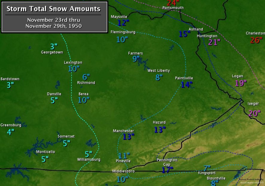
Here ya go guys. That one ruled the roost here as far as November Snowstorms. A true Blizzard ! Cars were completely covered here in Lee County from huge drifts . Higher eles. of County received 2 ft.+. Drifts much higher. Temps were in teens during day.
-
2
-
-
3 hours ago, John1122 said:
A year ago today we were getting snowfall. It actually was Knoxville's largest event of cold season per WVLT.
4" here from that last year.
-
2
-
-
13 minutes ago, uncle W said:
1975 had a positive Nov AO and 1978 had a very positive AO for November...2020 is hitting those high notes...Dec 1975 and Jan 1976 were cold despite the positive ao...1978 had a reversal of the positive ao the end of Dec...Feb had a great period of cold and snow...Feb 1976 had some snow the first week of Feb...I think the winter will start out mild until mid January or so...snowfall will be light until possibly Feb...One good week or two in Feb...analogs are 1974-75...1985-86...1971-72...these are my thoughts now...there is time for the pattern to change before Christmas as did in 1975...overall if we dont get a major storm like 2006 the winter will end up disappointing...time will tell...
You have 74-75 as an analog. Didn't u mean 75-76 ?
December 2020 Medium/Long Term Pattern Discussion.
in Tennessee Valley
Posted
Yeah, for sure John. Still some hope for last nights depiction to be possible, with enough NA blocking and that NE PAC warm pool as Carver aluded to. But, with the Nina, in particular it's strength, this new depiction has greater odds of happening i.m.o, unfortunately .
Maybe, it'll be more back and forth between the 2. If so, we can work with that.