

Daniel Boone
-
Posts
2,102 -
Joined
-
Last visited
Content Type
Profiles
Blogs
Forums
American Weather
Media Demo
Store
Gallery
Posts posted by Daniel Boone
-
-
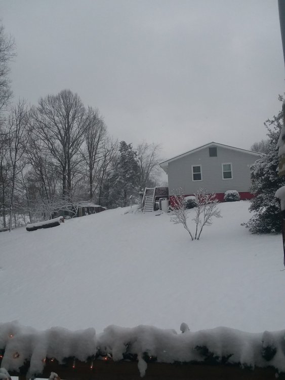
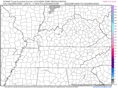
5.1" Total here. Rgem best. GFS worst as far as at short range for Lee County once again.
Don't know what they did to the GFS that last upgrade but, it consistently underforecasts Snowfall and precip in general for this area...could be bad data from the area having been fed n2 it. Couple sites notorious for that in Lee County. Could be overemphasizing downsloping.
-
 7
7
-
-
1 minute ago, Cotton7204 said:
Got right at 3 inches in Clintwood, Va, Sort of hit and miss in around here, Ive heard someone in big stone gap have 6 inches, and 5 inches in southern Dickenson county.
4.2 in Jonesville. Some places had periods of larger flake Snow than others of which mounted up a good bit more.
-
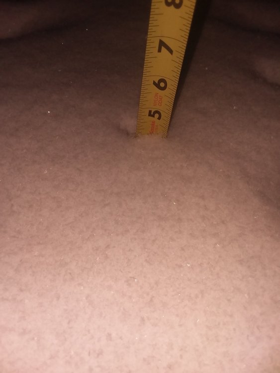
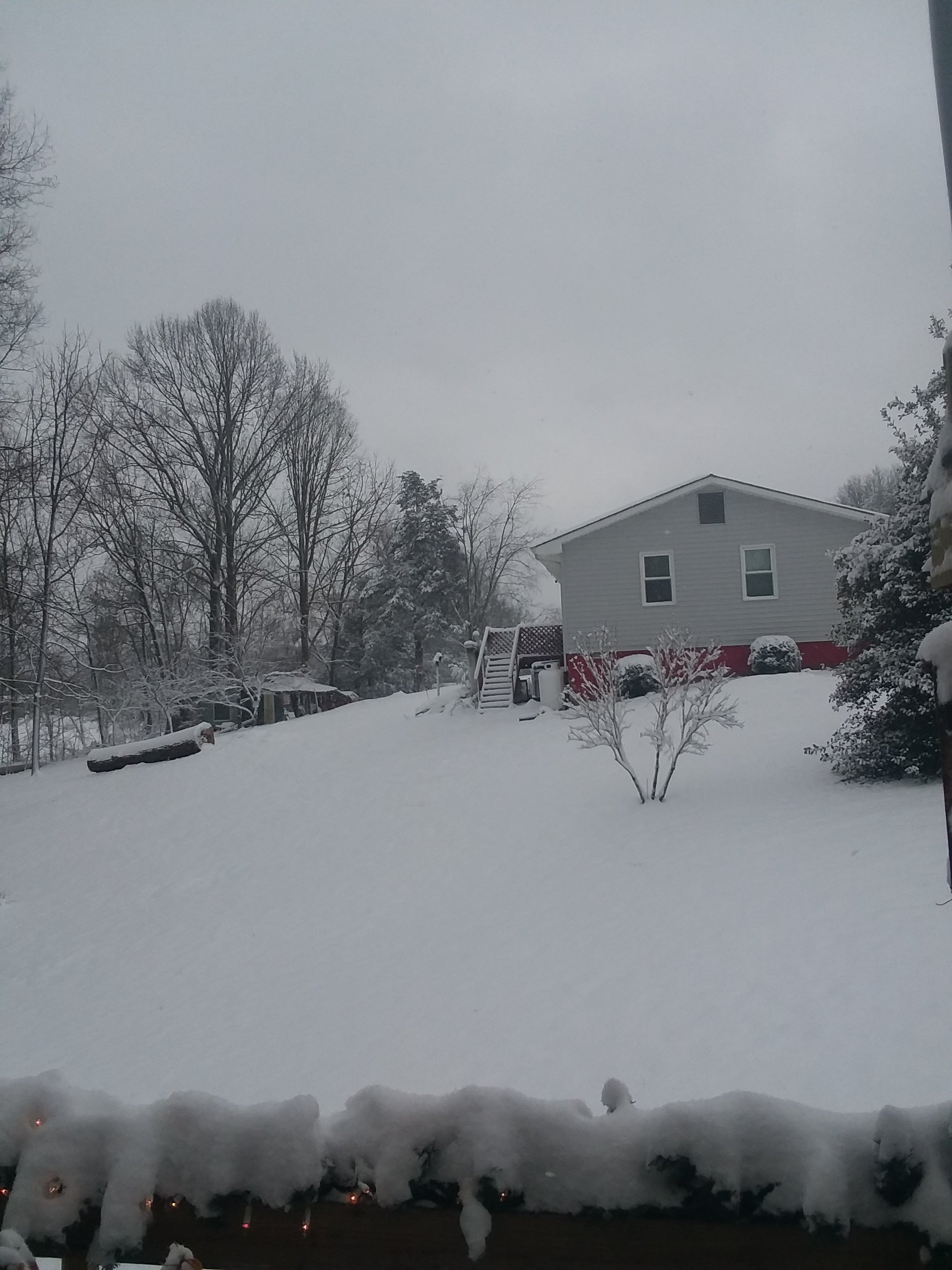
Measured 4.2" here as of 8:35 p.m..
-
5
-
-
Ground becoming white in Jonesville.
-
2
-
-
Rain began mixing in Jonesville, Lee County, Va at 4 and then sleetetd for about 15 mins. Now all Snow.
-
3
-
-
3 minutes ago, John1122 said:
Just flooding down rain. Gonna be so close to ending here when the cold arrives. Just have to hope the backing happens. I may be too far West and this might be the time things verify more East than west on a modeled precip shield.
Sure hope things work out 4 you all back that way with the backing synoptic. Even without that you'll still do decent with the banding, I believe.
-
3
-
-
2 hours ago, Holston_River_Rambler said:
12z Euro:
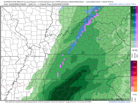
Big ole 11 inch lollipop for Wise. High Knob and Black Mountain over a foot !
-
3
-
-
Kmrx going with latest sref. Saw a conversation with Ricky Mathews (wcyb Met,),on Twitter. Ricky brought up the earlier 5.3" plume for Knox. They rebuttled with latest run downtrend I guess why they're going as low on totals.
-
1
-
-
57 minutes ago, John1122 said:
The RGEM has scored several wins before, usually related to northern stream events. These anafrontal low spin ups are rare these days but used to be a common way to get 3 to 5 inches imby.
Yeah, used to happen regularly back in the day.
-
1
-
-
At some point they should start going with the short range, at least to some degree alongside the Euro. Surprising they've not already started going with the Nam somewhat. Could be, the pretty sizable outcome difference and the Forecasters belief in the Euro/UK solution.
-
How strong are the winds progged to be with this ?
-
This still may intensify n2 a blizzard of sorts west side of Apps /eastern Ohio Valley.
Doesn't have to be enormous snow amounts to meet criteria. Today's standards dont even dictate Temps below 20 of which this will even have in much of it IF Storm comes to fruition.
-
Let's hope we don't wind up with an 2004 scenario and the stronger, west trend continues and the areas west get pummeled while we end with a dusting.
-
We wanted that L.P. to develop and trend stronger and further south but, not overly so as far a strength.
One bit of concern for portions of the area is the actual possibility of Blizzard criteria being reached ! Amazing after things looking rather benign. Powerful sharp arctic blasts have been known to spawn one .
-
21 minutes ago, Carvers Gap said:
If you live in NE TN(really all of E TN), not a trend you want to see from the NAM. Now, it is the NAM past 48 hours and it has a problem with over-amping systems. The slp is stronger with the NAM by several millibars. That in turn sharpens the storm and changes the angle into the region. Snow axis moved about 200 mi west in KY from eastern KY to middle KY.
Exactly! Big trend West.
-
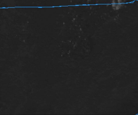
2 hours ago, Holston_River_Rambler said:
Plateau sunset:

You can hear the wind aloft. Something fun must be going on higher up. I took a short time lapse of the clouds rolling.
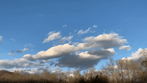
You can actually see this cloud formation on the local GOES 16 imagery, at the bottom of the Frozen Head mts.
Really, just a vividly blue sky, after the drear of late.
Good stuff right there !
-
Just now, TellicoWx said:
That looks about like middle ground right now...north end = WV, south end = NC/GA/SC border
Need that South end for optimal production.
-
2
-
-
Wasn't the November 12th one last year an anafrontal wave that dumped several inches throughout the area ? I remember models had this area as the rather low end forecasted amounts and Claiborne and Lee recorded the most. 4 to 7".
Although, that one didn't have any substantial Downsloping winds though so, probably why.
-
1
-
-
I remember that one well. Several inches throughout Lee County.
-
42 minutes ago, Carvers Gap said:
In all seriousness, the pattern that is being depicted on LR models and Weeklies runs(CFSv2 and Euro) has one of the most impressive NAO setups that I can remember. Pacific is TBD. That said, looks like we are going to see some storms take the low road. If that verifies, January would have some opportunities I think. Trying to temper my excitement. After last winter, anything looks better. But honestly, the overall pattern looks old school good at times.
Like your old school comment buddy. Winters of Yore !
When you're an Antique like me and have been in the weather business as long as I have, you definitely know about "old School".
-
2
-
-
12 minutes ago, TellicoWx said:
Euro finally popping a surface low on the Lee side..just over WV.

That's what the UK snow map reflection appeared to be indicating ; further north development . Let's just hope doesn't trend even further for us upper forum folks. Hopefully, will revert back as we get closer.
-
3
-
-
36 minutes ago, Kentucky said:
ouch
Basically showing some reflection of a wave. Moisture starved and maybe getting going further north. Hopefully wrong but, the way things are for us theses days, probably right.
-
7 minutes ago, wncsnow said:
The OP is insistent on a storm track through the OH valley or Midwest. Nothing close to a snowy pattern shown on the OP
Yeah, 2nights operational looks terrible. Pops a SE Ridge by New Years ! Don't buy that, particularly with strong blocking setting up. I think it screws up with the L.P. drifting out in the Atlantic east of NC instead of moving NE toward NF . Also, west coast trough pendulum effect.
-
1
-
-
CMC and GFS Operationals went in the crapper tonight. GFS manages to somehow pop a SE Ridge by New Years. Don't know how it came to that equation.?!?!


Christmas Eve/Christmas 2020 Arctic Express Snow Obs.
in Tennessee Valley
Posted
Yeah, actually meant to mention it was best several days out for our area. Canadians ftw for our area !