
NCBlizzard
-
Posts
706 -
Joined
-
Last visited
Content Type
Profiles
Blogs
Forums
American Weather
Media Demo
Store
Gallery
Everything posted by NCBlizzard
-
2025-2026 Fall/Winter Mountain Thread
NCBlizzard replied to Buckethead's topic in Southeastern States
Thanks for the insight. I'm pumped to get a spot and have a lot less frustration due to the lack of snow in the Piedmont haha. Cheers! -
2025-2026 Fall/Winter Mountain Thread
NCBlizzard replied to Buckethead's topic in Southeastern States
100% haha. My other half says that's too far from "things"... Alas, so ideally like within ~20-30 minutes of the general Boone/Blowing Rock or Asheville area. -
2025-2026 Fall/Winter Mountain Thread
NCBlizzard replied to Buckethead's topic in Southeastern States
If anyone has a moment, I’d love your thoughts on this “NW-flow snow favorability” map (especially whether it’s capturing the patterns you’d expect). Mobile is a bit rough unless you rotate to landscape. I’ve wanted mountain property for decades, so I’m doing as much pre-analysis as I can haha. http://44.197.87.201:3839 -
January 30th- Feb 1st ULL and coastal storm obs
NCBlizzard replied to JoshM's topic in Southeastern States
Ended the event with about 10.5" here in Belmont NC. Whopper of a storm. I'm glad to see Triangle folks were able to rake some in as well! -
January 30th- Feb 1st ULL and coastal storm obs
NCBlizzard replied to JoshM's topic in Southeastern States
https://forecast.weather.gov/product.php?site=NWS&issuedby=MHX&product=PNS&format=ci&version=1&glossary=1 -
January 30th- Feb 1st ULL and coastal storm obs
NCBlizzard replied to JoshM's topic in Southeastern States
We are right at 5.5" here in Belmont and still coming down steady! Temperature has dropped to 19° - despite solar noon having been ~1 hour ago. Incredible. -
January 30th- Feb 1st ULL and coastal storm obs
NCBlizzard replied to JoshM's topic in Southeastern States
Truly pouring major flakes. It's like a snow globe outside. Right at 4" in Belmont. Averaging rates of about 0.8" hour since 8 AM. Temperature is down to 20°. -
January 30th- Feb 1st ULL and coastal storm obs
NCBlizzard replied to JoshM's topic in Southeastern States
Really hoping things work out at least to some degree up that way for y'all. Just moved to Belmont a few months ago from Durham, and now surprised I'm better off here than there re snow (nowadays, at least, since this area has missed out a lot over the past 10 years). -
January 30th- Feb 1st ULL and coastal storm obs
NCBlizzard replied to JoshM's topic in Southeastern States
Even with 3 snowboards out in various places, none seem to be fully exempt from the (sometimes massive) waves of blowing snow that are coming off trees/houses - trying to measure hourly at least to best gauge actual accumulation. -
January 30th- Feb 1st ULL and coastal storm obs
NCBlizzard replied to JoshM's topic in Southeastern States
Approaching 2" in Belmont. It is an absolute whiteout outside right now! It's 21.8° on my station here and still steadily dropping. CLT has been reporting visibility of 0.25" and "Heavy Snow" since 9:00. -
January 30th- Feb 1st ULL and coastal storm obs
NCBlizzard replied to JoshM's topic in Southeastern States
After a lull, light snow again in Belmont. Radar is looking good. -
January 30th- Feb 1st ULL and coastal storm obs
NCBlizzard replied to JoshM's topic in Southeastern States
Roughly 0.6-0.7" in Belmont at 6:00. Temperature is 26.4°F (right in line with latest HRRR for here). I-85 corridor GSP to Kannapolis about to really see thinks pick up over the next 1-2 hours it seems. -
January 30th- Feb 1st ULL and coastal storm obs
NCBlizzard replied to JoshM's topic in Southeastern States
Returns NE of Charlotte still hanging on as they continue moving towards Greensboro/Raleigh. HRRR doesn't have them making it all the way there quite yet (dries them up around Randolph County), but perhaps it will be wrong. -
January 30th- Feb 1st ULL and coastal storm obs
NCBlizzard replied to JoshM's topic in Southeastern States
Eclipsed 0.25" here about 10 minutes ago. It's really coming down out there, even under lighter returns now. Much bigger flakes. I think it's certainly safe to say the DGZ has already started deepening, and is certainly saturating! -
January 30th- Feb 1st ULL and coastal storm obs
NCBlizzard replied to JoshM's topic in Southeastern States
I'm feeling pretty good about your area up through CLT! -
January 30th- Feb 1st ULL and coastal storm obs
NCBlizzard replied to JoshM's topic in Southeastern States
Under brief heavier returns, total change in flake size. Had some massive dendrites falling. Temp down to 27.5°. Besides one pesky 5 minute interval, CLT has been observing light snow for an hour so far, since 3:40. -
January 30th- Feb 1st ULL and coastal storm obs
NCBlizzard replied to JoshM's topic in Southeastern States
Not from the meso low as described in that post, but general ascent from the ULL itself will support a swath of snow around ATL and N&E towards daybreak as well. -
January 30th- Feb 1st ULL and coastal storm obs
NCBlizzard replied to JoshM's topic in Southeastern States
Steady light snow in Belmont. Ground is whitening and cars are starting to be covered. Radar is filling in nicely as well. Some particularly heavier returns popping up over the Charlotte area and to the SW into the upstate. Surface temperature starting to drop as well, down to 28.5°. -
January 30th- Feb 1st ULL and coastal storm obs
NCBlizzard replied to JoshM's topic in Southeastern States
Flurries have started off and on in Belmont. 29° -
January 30th- Feb 1st ULL and coastal storm obs
NCBlizzard replied to JoshM's topic in Southeastern States
37°F in Belmont, NC. Pumped to see any amount of snow, truly. What's everyones plan for sleep haha. I think I am going to try a brief nap here soon, waking up around 3-4 AM as of now, don't want to miss a moment - worried I'll end up just staying up all night and tomorrow! -
The “I bring the mojo” Jan 30-Feb 1 potential winter storm
NCBlizzard replied to lilj4425's topic in Southeastern States
AIFS 10:1 snowfall totals. Both AIGFS and AIFS highlighting possible precip maximum somewhere in the Charlotte vicinity.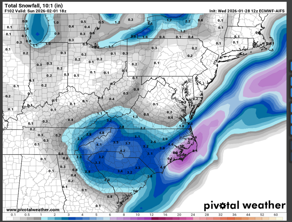
-
The “I bring the mojo” Jan 30-Feb 1 potential winter storm
NCBlizzard replied to lilj4425's topic in Southeastern States
I approve the trend.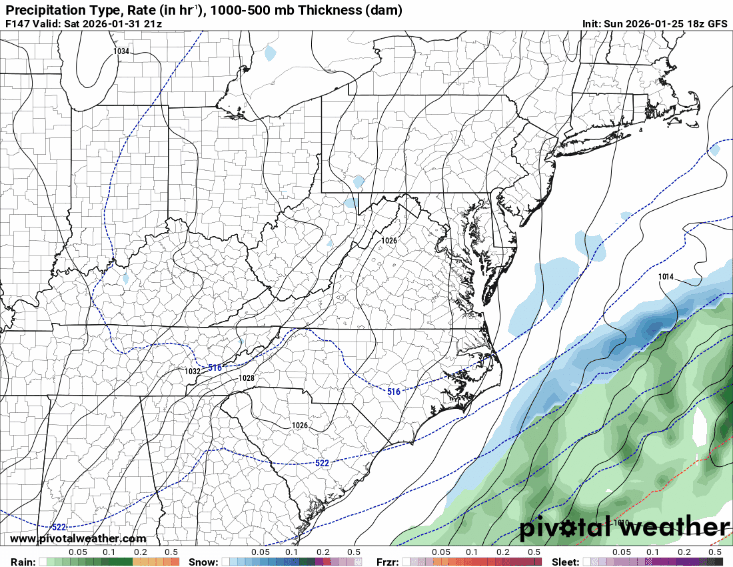
-
The “I bring the mojo” Jan 30-Feb 1 potential winter storm
NCBlizzard replied to lilj4425's topic in Southeastern States
I have usually found the snow depth parameter to better represent what we actually measure on the ground, and it's a beaut as well.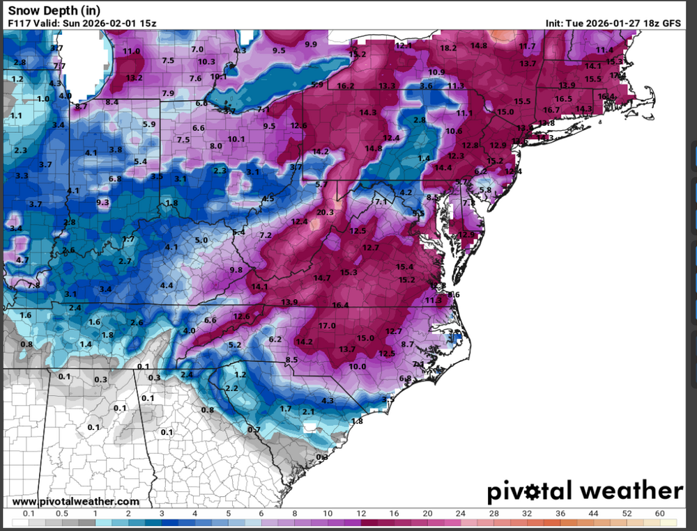
-
The “I bring the mojo” Jan 30-Feb 1 potential winter storm
NCBlizzard replied to lilj4425's topic in Southeastern States
GFS has come in looking good. Strong low off the coast, ULL looking decent. Good trends I think. Kuchera through 12z Sunday.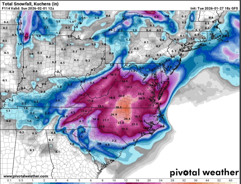
-
Southern Crippler - Get well soon Jimbo Storm Obs
NCBlizzard replied to BooneWX's topic in Southeastern States
Total QPF here in Belmont/Cramerton was 0.54". 1.2" sleet (a bit of snow mixed within that as well, but minimal, and only due to super cold CAD allowing some "dendrite-esque" precip to reform right beneath the warm nose which was quite fascinating). 0.18" ice accretion


