
NCBlizzard
-
Posts
706 -
Joined
-
Last visited
Content Type
Profiles
Blogs
Forums
American Weather
Media Demo
Store
Gallery
Everything posted by NCBlizzard
-
The “I bring the mojo” Jan 30-Feb 1 potential winter storm
NCBlizzard replied to lilj4425's topic in Southeastern States
I was indeed somewhat impressed in the Euro AI. I wish I had done a bit more comparison of it against the AI GFS. Not sure if anyone has thoughts on that comparison specifically? -
The “I bring the mojo” Jan 30-Feb 1 potential winter storm
NCBlizzard replied to lilj4425's topic in Southeastern States
Decent amount of moisture. Would be nice to see a Kuchera map given the cold air (even though that's just splitting hairs at this point)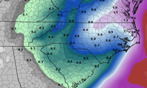
-
Southern Crippler - Get well soon Jimbo Storm Obs
NCBlizzard replied to BooneWX's topic in Southeastern States
Things have wrapped up in Belmont. Measured 1.2" sleet/snow and 0.18" ice accretion (basically exclusive (0.15") from the final band that passed through). There could have been more sleet fall since compaction of course happened, but that was the measurement as of right now. Temperature is up to 30. Can surprisingly hear slight dripping from gutters/trees. -
Southern Crippler - Get well soon Jimbo Storm Obs
NCBlizzard replied to BooneWX's topic in Southeastern States
100% freezing rain now here in Belmont. Quickly racked up ~0.3-0.4" sleet beforehand. -
Southern Crippler - Get well soon Jimbo Storm Obs
NCBlizzard replied to BooneWX's topic in Southeastern States
Slowly transitioning to predominantly freezing rain in Belmont. The heavy sleet has actually been really cool and unique to just stand outside in. Temp is 24.6, rising at a rate of about 1.2° per hour now -
Southern Crippler - Get well soon Jimbo Storm Obs
NCBlizzard replied to BooneWX's topic in Southeastern States
Quite heavy sleet here in Belmont. Accumulating fast. No thunder yet, sadly. I am honestly quite surprised it's not freezing rain -
Southern Crippler - Get well soon Jimbo Storm Obs
NCBlizzard replied to BooneWX's topic in Southeastern States
Freezing mist (occasional drizzle) in Belmont NC. Temp is 21.7. Glaze on cars and deck. This will be interesting... -
Southern Crippler - Get well soon Jimbo Storm Obs
NCBlizzard replied to BooneWX's topic in Southeastern States
I definitely recommend RadarScope. Not sure if without subscription you can see them, but the $10 per year is so worth it. -
Through 1/26 03z, I still see a solid wedge (00z GFS)? Regardless though, it's hard for me to believe the wedge is scoured such, although perhaps it will be, as another important learning/data point. I was certainly hoping the trends with 00z would be more in our favor - especially since the GFS ingested a notable amount of additional obs from NOAA recon (not sure of assimilation of this data into GEM/EURO etc)
-
With last system last weekend, HRRR was consistently warmer than obs for surface temperatures and didn't have a good handle on radiative influences in my opinion, but it did indeed do quite well with overall depiction of the small areas that would end up with some token flakes / a dusting (in NC at least), much better than the NAM. However, way too far out to put much stock in the HRRR.
-
I can't imagine a scenario where that would happen, although anything is possible... I would hedge against massively and always consider sleet a saving grace when it comes to power outages 99.99% of times.
-
Can you provide link to source url? Thanks! Sent from my SM-S928U using Tapatalk
-
I am so very sorry to hear this. While this post was a while ago, he was certainly worthy of continued recognition. His messages here frequented my screen for 10+ years. Wishing you the best.
-
Regardless of model, I have often found the "snow depth" field to better represent what you actually experience on the ground, with melting etc - almost like Kuchera+. But some like the GDPS don't use Kuchera for calculating snow depth (just 10:1). I'm not sure which models do/don't, or what site has snow depth derived with Kuchera.
-
Cold front looks to me to be moving at forecast speed, and maybe a little quicker in S TN/N AL based on dew point. Temps here (Belmont, NC - just W of CLT) are running 1-2°F warmer than what was forecast for right now, but that's mostly noise I'd say. Not expecting much of anything here, but the eastern Piedmont/coastal plain at least has a much better chance (Triangle -> SE to 95).
-
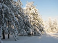
Measured an additional 1" fresh snow today. As others mentioned - the flake sizes were incredible. Event total of about 4.2". Awesome system!
-
3" now at a cozy 24.4°F. As of about 15 minutes ago - at least 30-40% of what is falling is now graupel (I don't think it's quite sleet), perhaps as the DGZ is slowly drying out. Not sure. Beautiful wintry day though. Best in many years.
-
February 19-20 Major Winter Storm Threat
NCBlizzard replied to NorthHillsWx's topic in Southeastern States
HRRR initialized snow depth looks reasonable, and paints a pretty picture for the next 6 hours for many in Triangle east/NE -
Transition line right now definitely shifting east on CC. Hopefully those mixing get pure snow here very soon!
-
I actually did mow mine haha - even though I wasn't too optimistic. Right at 2" here 2 mi. NNW RDU. Temp is 25.3°
-
I'm feeling that if you're super close to the transition line now or just on the sleet side, that is not a bad spot to be given the enhanced precip build back to the west continuing more than progged and inevitably the transition line collapsing SE as WAA shifts.
-
I was just actually thinking through this ha. It seems there is indeed technically a difference, with graupel having notably more structural change to the crystal structure under heavy rime. Delicate balance for sure
-
I'm always pessimistic with regards to sleet, but my gut says the sleet line may come a little further north than it is now - but quickly like within 1-2 hours stall and start progressing more eastward as more CAA takes over from NW.
-
I noticed some rimed flakes an hour or two ago, but right now just massive fluffy flakes. Roughly an 1" here but rates have increased tremendously
-
Here near RDU, treated roads becoming solidly covered. Few car accident near Glenwood/Page Rd. It's getting messy for sure

