

Rd9108
-
Posts
3,850 -
Joined
-
Last visited
Content Type
Profiles
Blogs
Forums
American Weather
Media Demo
Store
Gallery
Everything posted by Rd9108
-

Pittsburgh/Western PA Winter 2024-2025 Thread
Rd9108 replied to Rd9108's topic in Upstate New York/Pennsylvania
Last post before I head out. From the same met. The kinds of busts that often happen are when more mesoscale features make or break a forecast. A lot seems to hinge on the WV low pressure that develops from mountain-related effects.Globals, including even the new UKMET, are giving a nod to the HRRR with this possibility this afternoon. Big shift upward with snowfall totals compared to last evening's run. -
That does seem to be the case. We need the primary to hang on longer and stay stronger if we want the HRRR to play out. Seems like some of the models are under doing the northern precip shield. Not expecting a complete bust, but we've seen weird thing with storms that cause some huge busts.
-
FYI reports out west are showing that precip is falling in places that NAM said there will be zero precip.

-
Pittsburgh/Western PA Winter 2024-2025 Thread
Rd9108 replied to Rd9108's topic in Upstate New York/Pennsylvania
He says Mping confirms this is reaching the ground. -
Pittsburgh/Western PA Winter 2024-2025 Thread
Rd9108 replied to Rd9108's topic in Upstate New York/Pennsylvania
So if we look out west precip is stronger and falling further north and even earlier than models like the 3k had it. Obviously every little detail matters but maybe a sign of trends out our way. Took this from another forum from a local met.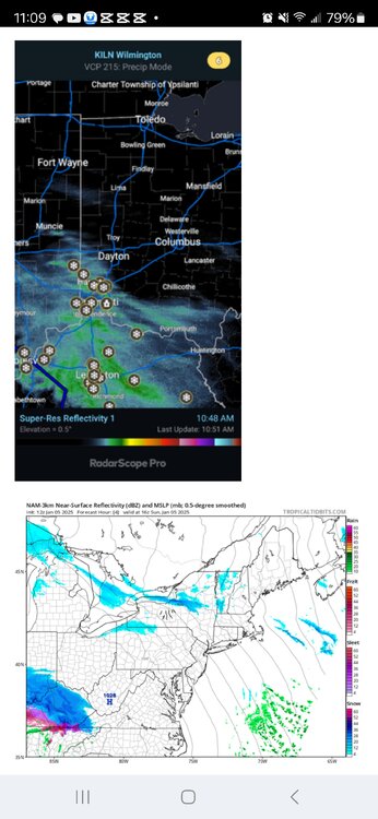
-
Pittsburgh/Western PA Winter 2024-2025 Thread
Rd9108 replied to Rd9108's topic in Upstate New York/Pennsylvania
Yep just adding to the snow pack. Never believed the northern models since the Euro has stayed consistently south of the area with the snow band. Hopefully this overperforms. -
Pittsburgh/Western PA Winter 2024-2025 Thread
Rd9108 replied to Rd9108's topic in Upstate New York/Pennsylvania
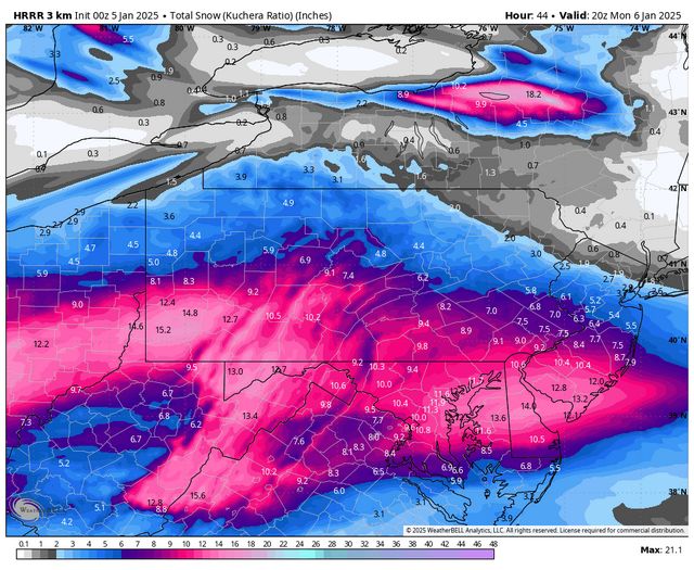
Latest HRRR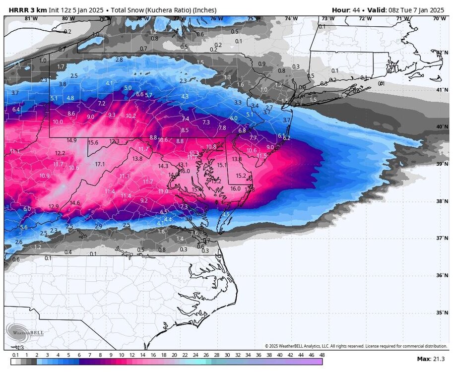
-
-
Pittsburgh/Western PA Winter 2024-2025 Thread
Rd9108 replied to Rd9108's topic in Upstate New York/Pennsylvania
Nothing we can do but track and keep our expectations low. -
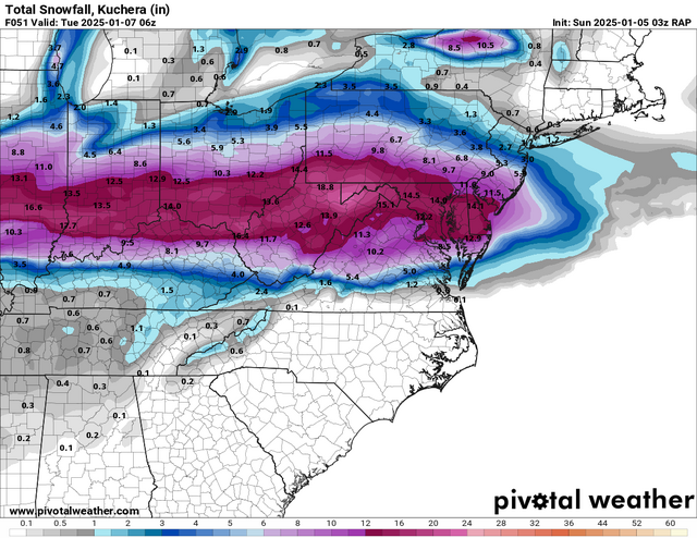
It will look something like this
-
I'm hoping the confluence is overdone. That precip shield gets destroyed on the northern side.
-
Pittsburgh/Western PA Winter 2024-2025 Thread
Rd9108 replied to Rd9108's topic in Upstate New York/Pennsylvania
Yeah its not that the storm is south. The confluence just looks like it kills the precip shield. WAA always wins right..? -
NAM looks like poo
-
The difference between 3 and 14 for my area is ridiculous. Pittsburgh would shut down for the day.
-
Pittsburgh/Western PA Winter 2024-2025 Thread
Rd9108 replied to Rd9108's topic in Upstate New York/Pennsylvania
-
Pittsburgh/Western PA Winter 2024-2025 Thread
Rd9108 replied to Rd9108's topic in Upstate New York/Pennsylvania
Gotta smell the sleet they say. -
Mix line getting dangerously close but I'll take it.
-
Pittsburgh/Western PA Winter 2024-2025 Thread
Rd9108 replied to Rd9108's topic in Upstate New York/Pennsylvania
-
SREF
.thumb.png.1dbfd73865286cd6d8999f55cfc8eb3b.png.be3b2b1b313eca794f25801ceedd92d0.png)
-
Pittsburgh/Western PA Winter 2024-2025 Thread
Rd9108 replied to Rd9108's topic in Upstate New York/Pennsylvania
SREF north.thumb.png.1dbfd73865286cd6d8999f55cfc8eb3b.png.95a6fb5b24d60f214cec9c6394f6285b.png)
-
Pittsburgh/Western PA Winter 2024-2025 Thread
Rd9108 replied to Rd9108's topic in Upstate New York/Pennsylvania
Can't post the gif of the NBM but the trend is good. Through 3 model suites we have gone from 5 to almost 8 according to it. -
Pittsburgh/Western PA Winter 2024-2025 Thread
Rd9108 replied to Rd9108's topic in Upstate New York/Pennsylvania
It's the long range RAP. Not very useful at this range. Things have trended better over the past 24 hours. Still time for some poative trends but I think we could at minimum be looking at a high end advisory event. One thing I've noticed is that reports out west say that snow is accumulating heavier and further north than models had it. That could bode well for us down stream. -
Sheesh Pitt is getting some positive trends last minute. 30-50 miles away from a foot verbatim
-
Pittsburgh/Western PA Winter 2024-2025 Thread
Rd9108 replied to Rd9108's topic in Upstate New York/Pennsylvania
We can beat Houston. Idt we could beat Baltimore on the road or chargers at home. Chargers are playing good football right now. -
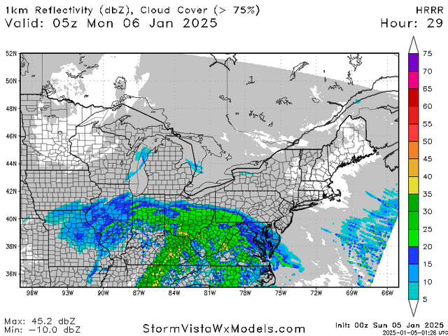
Snow barely even gets to the MD line on the Herpes
.thumb.png.e9ffb29e96719c314ecb76321a4e71df.png)


.png.9a0b815f7e20900155255e90d6defa50.png)