

jewell2188
-
Posts
550 -
Joined
-
Last visited
Content Type
Profiles
Blogs
Forums
American Weather
Media Demo
Store
Gallery
Posts posted by jewell2188
-
-
4 minutes ago, jaydreb said:
GEFS and EPS are worlds apart at 114 hours.
Ouch. I think it’s a sign.
-
 1
1
-
-
Wouldn’t it be much easier to assume the gfs is right at this point??? I mean, that negates all the potential heart break from the start lol.
-
38 minutes ago, pogoism9 said:
I do recall a few days prior to the Jan 2016 storm, we had a small ice event come through. That storm pretty much came though a few days later and it was like a lion attacking an already wounded gazelle

Yes! I live in the plains which is northern fauquier and I remember a couple days before we had a dusting to an inch proceeding that big storm.
-
How is it looks in terms of freezing rain?
-
Unconfirmed reports of 4-5 inches in culpeper and still SN
-
38 minutes ago, clskinsfan said:
Really enjoying watching the Patriots get stomped.
The Brady and bill storyline would have been great though!!!
-
Just now, PWC Split said:
I have lived here long enough to understand our climo. History says we get 2-3 inches, a little bit longer then expected period of frozen precip, and then rain. However, for some reason I have my weenie goggles on. Maybe it’s the bourbon talking, or maybe it’s the euphoria of the Bills pounding the Pats. Either way I am glass half full on this one.
I think you may be underestimating that mild ocean temp and strong easterly fetch we’re going to experience rather quickly. I would also say when have we boomed with this particular storm track ??
-
9 minutes ago, BristowWx said:
You’d be surprised how SE winds and warmer than they should be ocean temps can decimate cold air faster than mustard gets on a tie at a county fair…whatever that means.
Yep same people who said no way would snow stick after days in the 60’s. I think we’re all very lucky the entire event isn’t freezing rain….
-
22 minutes ago, WinterWxLuvr said:
You have to separate DT personally and professionally. Personality doesn’t change that he’s knowledgeable.
Well I mean last night his map was so laughable when even at the time of releasing, just about all model date strongly disagreed.
-
19 minutes ago, nj2va said:
His final call map will be out after precip starts.
He blocked me on Twitter after I don’t him his map was laughable.
-
I commented on DT “first call” and basically said his map won’t even come close to verifying for the majority of the DMV, he of course insults and I told him to reply back tomorrow when he finally realizes that his numbers are way off. The guy literally is a joke.
-
Actually sad to hear about sue at fox5. I grew up watching sue, Doug hill, Ryan, and topper. All the originals slowly disappearing. RIP Doug hill!!!!
-
 3
3
-
-
14 minutes ago, nj2va said:
For the snow map weenies

Highly doubt given the track that’s accurate. I think it’s safe to say at this point it’s going to end up a slop fest.
-
Just now, Steve25 said:
Frankly, at this point I'm just hoping for as little heavy rain as possible around Baltimore. If it's possible to go snow/sleet to dry slot, all aboard!
I mean the majority of the area could use a good soaking.
-
 1
1
-
 1
1
-
-
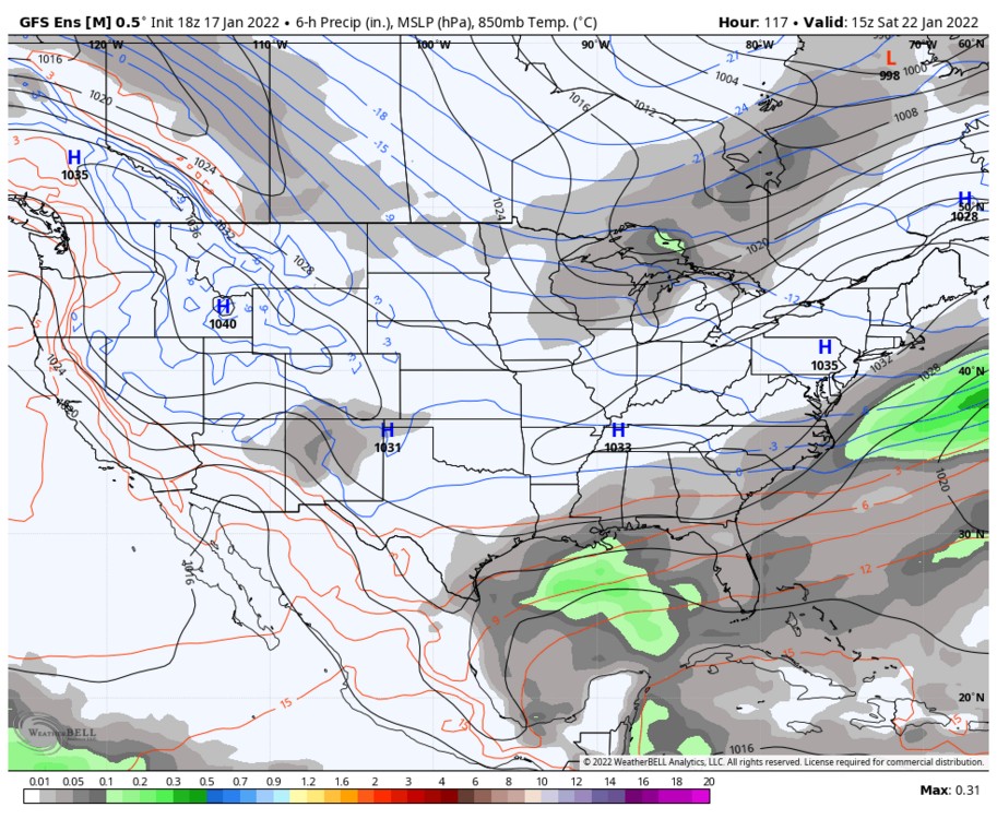
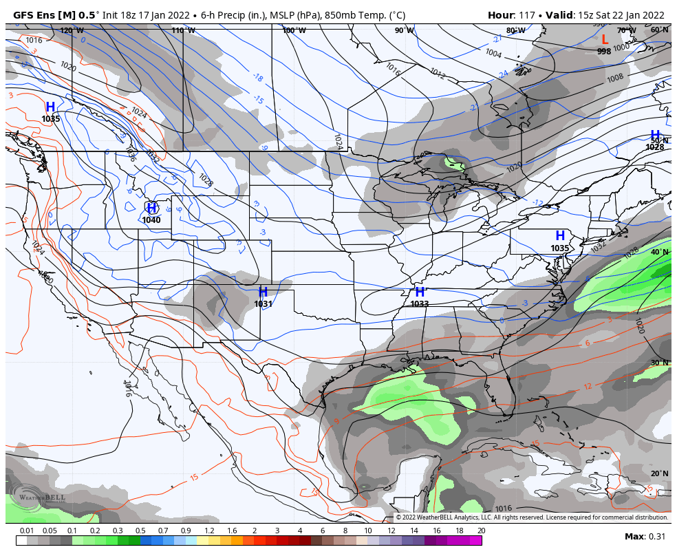
4 minutes ago, psuhoffman said:
I’m probably making it sound worse than it is. The 18z euro control (and it looked very similar at 90 to the op euro so I think it’s safe to say this is about what the 18z euro was just lower resolution) was fine. Just saying given what it looked like at 90-100 hours a but shocking the low ends up over Hagerstown. But this seems acceptable Imo. We can thank the cold airmass in place for these results despite the track.

Regardless of the airmass, doesn’t this map just look off given the track??? I find it hard to believe with a shitty track we even receive half of this….
-
5 minutes ago, psuhoffman said:
18z euro control does the same thing the Gfs does. Cuts the low from Wilmington NC to Hagerstown MD. Lol.
It has the same improved look at 90 as the op but it seems the more amplified SW offsets those other improvements. The storm gets to eastern NC then goes nuts. By then the confluence is gone and nothing but ridging over the top so nothing to stop it from cutting due north.
So what your saying is the likely hood of significant snow for the majority is not likely and the chances of it going back in our favor is closing fast?
-
11 minutes ago, WxUSAF said:
DT is riding the #snowtrain
https://dtwxrisk.medium.com/tuesday-730pm-update-on-jan-15-16-east-coast-winter-storm-d46de7f907e8
DT will ride his Richmond snowstorm until the first drop of rain falls.
-
3
-
-
17 minutes ago, leesburg 04 said:
I've been away for a bit how's this one looking?
The real question is what kind of BS is DT going to spill tomorrow? I’m sure he’ll blame Covid.
-
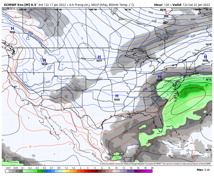
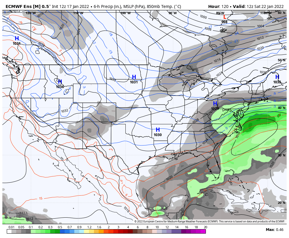
9 minutes ago, psuhoffman said:
18z eps is a pretty big step in the wrong direction. Both the ocean storm and tpv lobe trended west and more amplified which creates an even more suppressive flow. This one is bleeding the wrong way right now that’s for sure. Ggem looks best but it had a cutter 24 hours ago. Everything’s trending towards less spacing.
Ehh I had 85 hours in a truck last week between the two storms, not complaining for a little break.
-
Is this the year of last minute adjustments to give the area a decent storm?
-
1 hour ago, NorthArlington101 said:
Could be one of those events where trees, colder surfaces are slick even in places that aren’t below freezing given its fairly frigid tonight and tomorrow.Northern areas yes. Immediate metro, no.
-
21 minutes ago, Bob Chill said:
My personal guess is a big storm prob won't set up until a few of the legit cold troughs carve thru and create some highways. Maybe an overrunner or moderate event of any kind b4. Me thinks big storm potential is on the relax side of the cold pattern. Just a WAG. No real ideas on anything specific.
Rather be in the 60’s the days leading up to a 6-12 incher versus 20’s and low 30’s for highs and no snow lol. Heck we pulled it off earlier in the week!!!!
-
Unless radar fills in, majority of the rain shield looks to be west of 81 I think anyone in the immediate nova/DC area expecting more than an inch are going to be highly disappointed. Maybe some isolated higher amounts but current radar depiction doesn’t look good if your rooting for a lot of rain.
-
1
-
 1
1
-
-
23 minutes ago, RDM said:
Recall some of the compounding elements of the impact of Katrina was the failure of the levees and the failure of the main pumping stations. No implying the pumping stations could have kept up with the onslaught of the surge when the levees failed, but the failure of the pumps contributed to the longevity of the impact after the surge receded. Once the water inundated the wards that were supposed to be protected by the failed levees there was no way to pump it out. Will be interesting to see how the damage compares between Katrina and Ida in the coming days/weeks. Hopefully the $Billions spent on improving the levees and other infrastructure will prove the investment was worth it.
I would say yes. At roughly $16 billion i would think improvements have been made. From the reports some areas outside the levee protection are bad but areas within are okay. The real question is a storm that sustains long term cat 3-4 strength how will that investment stand up? Again maybe I’m putting to much thought into it but i think it’s a legit conversation.

Thursday 1/20/22 Stat Padder Discussion and Observations
in Mid Atlantic
Posted
Not sure what that means lol