

jewell2188
-
Posts
550 -
Joined
-
Last visited
Content Type
Profiles
Blogs
Forums
American Weather
Media Demo
Store
Gallery
Posts posted by jewell2188
-
-
11 minutes ago, Eskimo Joe said:
^could you imagine that in this neck of the woods? Insane.
Devastation would not be the right word.
-
3 hours ago, yoda said:

That’s a painful map.
-
Looking like early thoughts are significant flood threat for the Carolinas from Ian….not sure what that could mean for our area??
-
Looks like a Florida impact and out to sea.
-
 1
1
-
-
Seems the ots solution is still the most likely outcome.
-
 1
1
-
-
8 minutes ago, leesburg 04 said:
I figured as much but the NAM just said I laugh at your later tonight
Looking like another fail. Ready for a dry fall.
-
31 minutes ago, Eskimo Joe said:
Yea, not looking too good. Hope I'm wrong and we get the goods.
Looks like we’re in for a dry fall! I own a 167 acres where i cut trails through down to a normally wide flowing creek,to ride atv’s….it’s all but dried up last month or so. Cant even go out and enjoy some riding without it being a dust bowl!!!
-
4 hours ago, yoda said:
Last chance severe for a while
.SHORT TERM /TUESDAY THROUGH WEDNESDAY NIGHT/...
On Tuesday, a cold front pressing eastward through the Ohio
Valley will present an active weather day across the Mid-
Atlantic. Downstream of this system, the air mass is likely to
remain very warm and humid. Forecast high temperatures are
expected to rise into the low 90s with heat indices to around
the century mark. Unlike the previous couple of days which had
subsidence aloft, increasing lift ahead of the trough will bring
more widespread convection to the area. Increasing surface-based
CAPEs of around 2,000-2,500 J/kg are noted in the guidance, but
with marginal vertical shear profiles. Accordingly, storms may
not be terribly organized aside from cells that attain more of a
line structure. Any such line segments would promote a damaging
wind threat. SPC`s Day 2 convective outlook places most of the
area in a Marginal risk for severe weather. Initially storms
should ignite along the lee trough during the early afternoon
before spreading eastward toward the I-95 corridor.
Additionally, some degree of flooding risk exists given PWATs
around 1.50-1.75 inches and the potential for repeat convection.
WPC highlights the entire area in a Marginal risk for excessive
rainfall.
What a boring period we have entered!!!
-
2 hours ago, IronTy said:
Whoever is responsible for putting air handlers in the attic deserves to live in an attic all summer. My upstairs thermostat barely reaches setpoint by morning. It's so hot in the attic the unit has to run basically nonstop all night. I have a top of the line trane inverter unit downstairs which has no trouble but alas heat rises. Looking forward to this weekend too.
That concept never made much sense. Although in a 3 story house to have the upstairs unit in the basement would create extreme challenges for running the duct work. I think a dedicated closet on the upper level is much more reasonable versus the attic.
-
What’s up for tomorrow ??
-
You have to feel sorry for the people in Kentucky. Extraordinary damage. Many loss of life. The company I work for made the trip. And it’s sobering. Perry county is where we are at. We do restoration work with water, wind and fire damage. Unfortunately the majority of houses that are still standing are and will be complete demo. I live in culpeper when last summer 6-9 inches fell…..and I saw what that did. But luckily it’s not a valley community. So you didn’t have the loss of homes and life. My point is more and more of these extreme events keep happening More often. For the folks who live here, they will remember this event till the day they die,
-
 3
3
-
 1
1
-
1
-
-
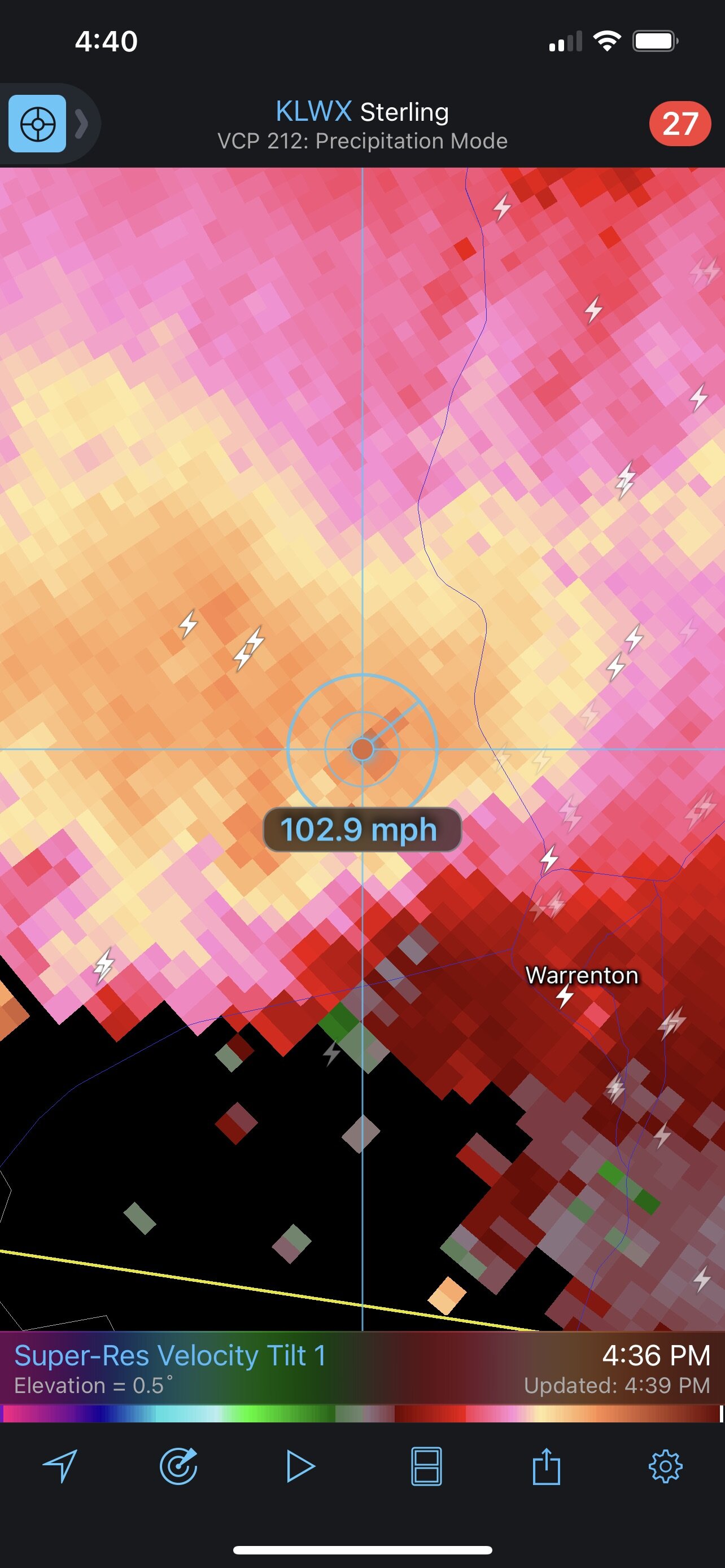
30 minutes ago, WxUSAF said:
Radar is not encouraging
I mean it really wasn’t 6 hours ago lol. It kinda went poof.
-
56 minutes ago, leesburg 04 said:
radar trajectory looks south of that to my untrained glass eye
I was going to say as well. Doesn’t look north at all.
-
17 minutes ago, Eskimo Joe said:
Tomorrow looks decent. Any time we have high CAPE and a big airmass change, someone wins.
Is it looking widespread or more scattered?? Or do we get the elusive enhanced risk that hardly delivers lol.
-
3 minutes ago, Kmlwx said:
It's for the urban areas mainly that have seen pockets of very heavy rainfall lately and are very prone to runoff. A quick 1 to 3 inches of rain from a progressive storm will still cause pockets of urban flooding. It's not for major river flooding in this case.
It would also seem a good portion of the area is primed for a major flood event at some point this summer due to a relatively wet season so far. Especially if we get some sort of tropical disturbance.
-
5 minutes ago, MN Transplant said:
Average Recurrence interval.
It is funny to see the AFD talk about widespread 1-3” with lollis to 4-7”, and then have the HRRR runs come in with virtually nothing for the metros.
It would seem no matter where you are, this has extreme bust or boom potential. Knowing our area I would side with bust atm versus boom.
-
21 minutes ago, southmdwatcher said:
So this is going to be a southern MD/central VA event??.......well at least most of us have relatively dry ground
?? I think this is going to be a DC north into Baltimore event. It looks like a zone from 66 south to perhaps Charlottesville give or take will be the screw zone with the exception of some pockets of heavy amounts.
-
Are we doing the usual models getting drier closer to game time !!?
-
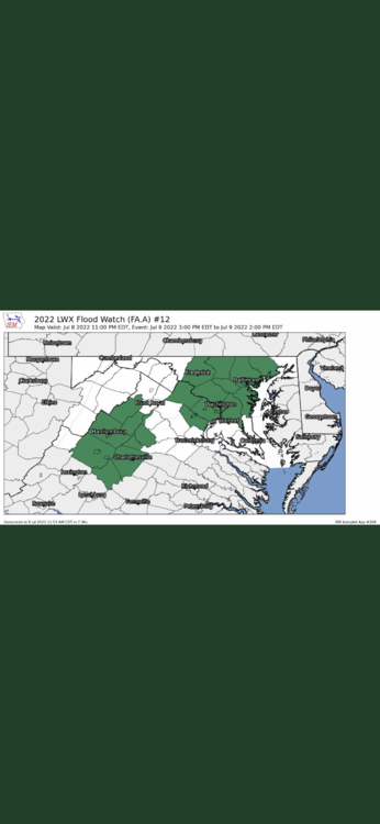
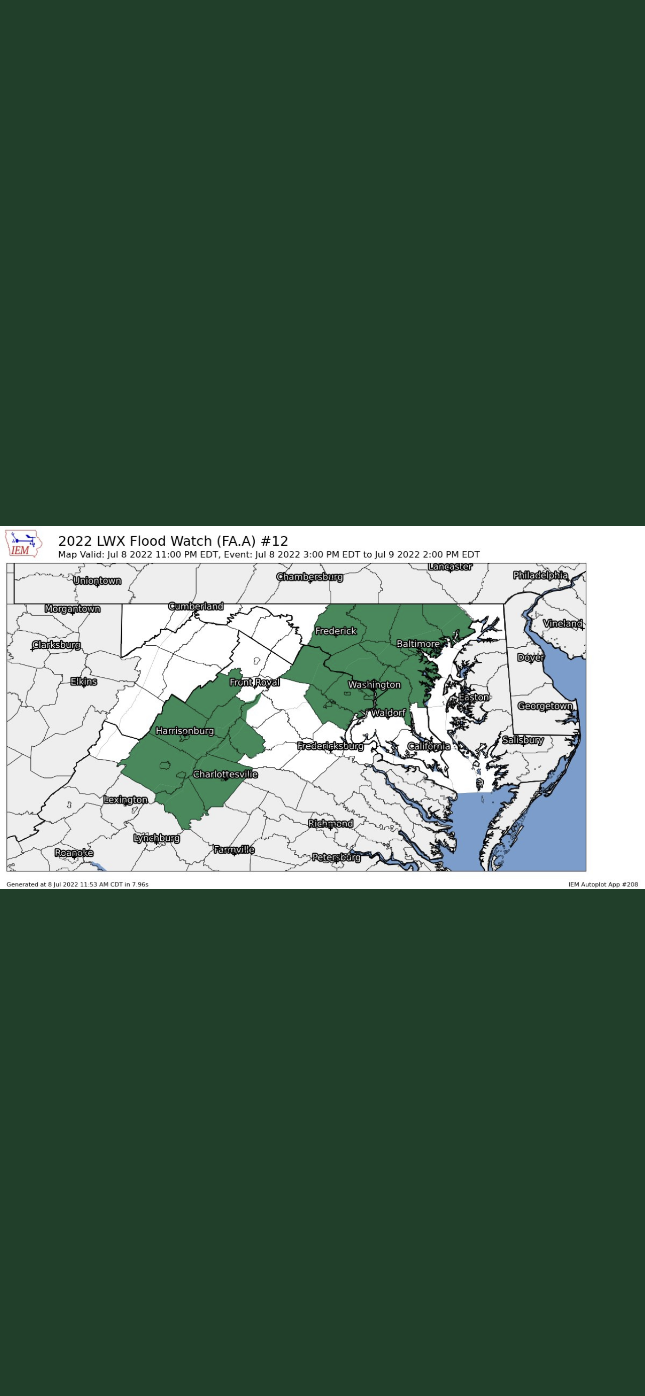
Can someone explain the 3 county gap in between the watch zone lmao???
-
13 minutes ago, yoda said:
18z GFS likes BR to i95 corridor for the heaviest rains... 18z 3km NAM is i81 corridor... 18z NAM is basically everyone lol
18z RGEM likes W into C MD with a E WV panhandle bullseye
Totals?
-
58 minutes ago, yoda said:
Guess we should watch and see what happens back in WI/IL/IA later in tonight
Why?
-
Same type of scenario happened last summer in culpeper county where 7-9 inches fell in just matter of hours. These extreme events keep happening more often.
-
1
-
-
6 hours ago, MN Transplant said:
Woof
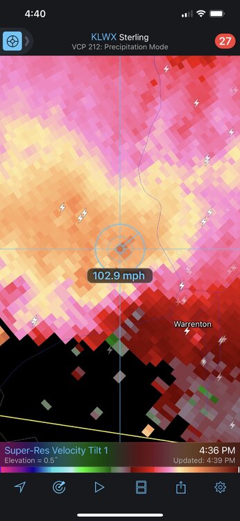
I can confirm extensive tree/power line damage in and around warrenton/northern fauquier county. The wind was unreal. Probably the worse I’ve experienced in this area. Ironically I think a lot of us slept on the severe threat compared the the flood threat. But today I’d say we over performed in the severe category. Maybe not area wide but today produced significant damage locally.
-
3
-
-
CWG update with some rather strong wording.
Remnants of Ian: Threat for us?
in Mid Atlantic
Posted
Starting to look like 2 landfalls. One would think more significant impacts for portions of our area. Seems like a non traditional track??? A landfall on the west coast of Florida and another on the southeast coast seems pretty unusual?? I guess we will see how things trend in the next 24 hrs.