

shaggy
-
Posts
7,429 -
Joined
-
Last visited
Content Type
Profiles
Blogs
Forums
American Weather
Media Demo
Store
Gallery
Posts posted by shaggy
-
-
32 minutes ago, yoda said:
06z GFS FWIW quick recurve out to sea this run
However the GEFS so far is weaker and further west versus the 00z GEFS
-
 1
1
-
-
18z gfs is very active long term
-
Gfs op run has no ensemble support
-
 1
1
-
-
24 minutes ago, Windspeed said:
I mean even now the mid level canopy/circulation is already tilted to the E/ENE of the low level vorticity maximum. A strong persistent convective envelope has allowed TCG to occur way in advance of modeling, hence now the TD. But it's going to be a prolonged struggle. It has certainly surprised already, but the same environment may keep it at best a weak TS until it reaches the northern Antilles.

Gfs through 66 is stronger and slower east of the Antilles so we will see what effects a stronger solution along with what you've already showed on the tilt having the ability to move this north of the big islands.
-
1
-
-
4 minutes ago, Windspeed said:7 minutes ago, WxWatcher007 said:The last 18 hours or so have been pretty impressive in a marginal environment. This has overperformed thus far. That’s a rough track for a LLC though if it played out like that.
Now that we have a well defined center I’ll be watching the next few model cycles to see if that changes track reasoning. Agree with others that this one likely has a cap in intensification potential through the five day forecast period due to dry air and shear.Shear may also impart track adjustments if the upper level vector is southwesterly. I'd stay it's not a horribly confident track position for the DR/Haiti at this stage. I'd be more inclined to see some slight poleward adjustments if the LLC gets tugged north of west downstream. Of course that relies on there being persistent deep convection. Long way to go. May be over the DR or might get tugged slightly north of the GAs. Patience will be a virtue watching this track verify.
Given the model mayhem with this one it's gonna be a headache for the forecasters no doubt. Going to be interesting to say the least.
-
1
-
-
11 minutes ago, Ed, snow and hurricane fan said:
CMC still having a party, but the reliable ensembles, the weaker systems run into the G Antilles where most die, and the stronger ones recurve. Looks decent on satellite.
06 GeFs is far more active with it.
-
1
-
-
6 minutes ago, GaWx said:
TWO remains 30%/40% but the wording seems slightly less bullish:
Tropical Weather Outlook
NWS National Hurricane Center Miami FL
200 PM EDT Tue Sep 13 2022

For the North Atlantic...Caribbean Sea and the Gulf of Mexico:

1. Central Tropical Atlantic:
Showers and thunderstorms associated with a tropical wave located
about 1000 miles east of the Lesser Antilles have changed little in
organization since this morning.  Although environmental conditions
are only marginally conducive, some gradual development of this
system is possible over the next few days.  A tropical depression
could form while the system moves westward to west-northwestward
over the tropical Atlantic and approaches the Leeward Islands on
Friday.
* Formation chance through 48 hours...low...30 percent.
* Formation chance through 5 days...medium...40 percent.
Hate to be in their shoes with the models having little to no consensus between them
-
1
-
-
It doesn't look horrible. Hard to get angood grasp on any singular idea as the models are pretty much across the spectrum like you said from some ensemble members having a hurricane to some not developing it at all. Let's see how well it sustains during DMIN today.
-
2
-
-
The models take the new typhoon Muifa to just east of Taiwan very near Ishigakijima Island and stalls it for 4 to 5 days. Would be a rough ride.
-
2 minutes ago, GaWx said:
Here we go again with the EPS. On the 12z, 5 of 51 (10%) hit the US as hurricanes 9/13-16 (2 FL 9/13 and 9/14), 2 hit NC (9/14 and 9/16), and 1 hits ME (9/14). Also, a few others are close.
On the 18Z GFS, 2 of 31 (6%) hit the US as a H on 9/14 (1-NC, 1-VA).
This is mainly for the record as it is just a longshot for a US hit as opposed to a concern at this time. However, it may be a bigger threat for the Canadian Maritimes. Also, Bermuda may need to watch this.
I noticed that slower camp on the gefs left it behind and turned it west again. It would be something to watch in real time if he is slower to lift out than modeled. That would be a nod to those ensemble members but it's not something thats likely to happen.
-
1
-
-
5 hours ago, WxWatcher007 said:
What a middling underperformer 91L has been. Models have no idea what to do with it.
Low level recon in now and still finding a disorganized mess so far.
Cmc with a 3000 mile shift. What a crap model.
-
Just now, GaWx said:
0Z UKMET is a little SSE of the 12Z, but it weakens it at hour 24 and doesn't bring it back like it did on the 12Z:
TROPICAL DEPRESSION 91L ANALYSED POSITION : 15.1N 50.0WATCF IDENTIFIER : AL912022
LEAD CENTRAL MAXIMUM WIND
VERIFYING TIME TIME POSITION PRESSURE (MB) SPEED (KNOTS)
-------------- ---- -------- ------------- -------------
0000UTC 31.08.2022 0 15.1N 50.0W 1008 26
1200UTC 31.08.2022 12 15.3N 50.8W 1009 25
0000UTC 01.09.2022 24 CEASED TRACKINGLooks better tonight on the northern end. Consensus still has it hit the breaks and turn sharply OTS.
-
@GaWx I notice a slight increase in western tracks for the gefs at 18z. They still miss but that sort of adds a slight hesitation of a full write off of this system.
-
1
-
-
4 minutes ago, Superstorm93 said:
Another interesting development
We could be tracking sheared trash into September
In all honesty we need a quiet season after the last several years.
-
2
-
-
1 hour ago, GaWx said:
12Z UKMET: 132 hour position is a bit NE of 0Z UKMET at 144; at 144 12Z is at 22.8 N, 65.0 W with NW movement:
TROPICAL DEPRESSION 91L ANALYSED POSITION : 14.3N 47.2W
ATCF IDENTIFIER : AL912022
LEAD CENTRAL MAXIMUM WIND
VERIFYING TIME TIME POSITION PRESSURE (MB) SPEED (KNOTS)
-------------- ---- -------- ------------- -------------
1200UTC 29.08.2022 0 14.3N 47.2W 1009 26
0000UTC 30.08.2022 12 14.2N 48.7W 1010 26
1200UTC 30.08.2022 24 14.9N 48.8W 1009 25
0000UTC 31.08.2022 36 15.3N 49.9W 1008 24
1200UTC 31.08.2022 48 15.7N 50.9W 1008 26
0000UTC 01.09.2022 60 16.5N 51.8W 1008 26
1200UTC 01.09.2022 72 17.1N 53.7W 1007 28
0000UTC 02.09.2022 84 18.1N 55.2W 1006 28
1200UTC 02.09.2022 96 19.3N 58.1W 1006 36
0000UTC 03.09.2022 108 19.7N 59.7W 1006 38
1200UTC 03.09.2022 120 20.7N 61.7W 1007 38
0000UTC 04.09.2022 132 21.4N 63.3W 1006 34
1200UTC 04.09.2022 144 22.8N 65.0W 1006 36The 12Z ICON at 168 is quite a bit east of the 0Z ICON at 180, a sign of reduced threat from that model at least for now. Since the ICON had been showing about the most dangerous looking solutions for the US, this 12Z run shift is very good news, especially for FL.
The 12Z GFS and CMC remain safely away from the US, but they both continue to threaten Bermuda.
The consensus of non-Euro 12Z models is thankfully to stay safely away from the US but that could change over the next few days if movement is further west than models are showing. Thus, it is still too early to make a call with high confidence, especially since there's still no TC center to track and the system remains messy, even though the model trends are clearly good news for now for the US though not for Bermuda.
Still a long ways to go on this one but the overall model trend has been towards a far less threatening scenario than the first series of runs a few days ago.
-
2
-
-
12z gfs is a carbon copy on track from its previous runs.
-
1
-
-
Until we get a system center and we start getting frequent GIV missions to sample the atmosphere it's still a toss up. We should have a system in SW Atlantic within threatening distance but whether it really threatens or recurve is still a pretty large unknown
-
1
-
-
2 hours ago, yoda said:
00z EURO says lets go BIG

The models are just worlds apart with this system. Let's see which one runs the most consistency.
-
1
-
-
2 hours ago, ldub23 said:
2 into 1? Dont look at the 18Z gfs then. I realize this is highly unlikely to happen. Even in the most active seasons you dont see this.

A bit later

2 potential major hurricanes approaching the US coast 600 miles apart on the same day?

Call an ambulance for JB!! I think he just fainted.
1996. Eduardo and Fran comes to mine just a different orientation as Eduardo recurved first and Fran hit
-
1
-
-
7 hours ago, GaWx said:
^The 0Z GFS on 8/30 hits Bermuda with the very dangerous right front quadrant of a major H. That makes 3 of the last 9 GFS runs with a H in the western Atlantic from the soon to emerge AEW.
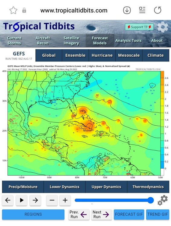
One concerning point is that while the 06z run still recurves on the OP the GEFS is much further west
-
1
-
 1
1
-
-
Madagascar going to take a big hit and then the models repeat a week or so later
-
Madagascar looks like it's gonna take a hit from a cst 3
-
-
49 minutes ago, Rjay said:
I like the interaction with the island and how the eye seems to bounce off if it. Sadly that left them in the eyewall for a long time.


Major Hurricane Fiona
in Tropical Headquarters
Posted
Anyone notice the 18z ensembles of other the eps and gefs. had more members slowing or stalling her around bermuda? Would be bad news for them if it stalled in their area