

shaggy
-
Posts
7,429 -
Joined
-
Last visited
Content Type
Profiles
Blogs
Forums
American Weather
Media Demo
Store
Gallery
Posts posted by shaggy
-
-
Mawar sat image is reminiscent of Dorian
-
-
1 hour ago, olafminesaw said:
I think it completed a few hours ago, but it ingested a ton of dry air in the process. This has caused a lopsided eye and a weakness on the north side of the storm. It seem to be starting to mix out the dry air and wrap convection around the eye, as the structure stabilizes. Weakening should at least stop before reaching Guam, and has a chance at re-intensification before landfall.

Yeah unless we see that eye clearing out again I'd say strengthening is unlikely before Guam
-
21 minutes ago, WxWatcher007 said:
Constant lightning around the eyewall. Such an impressive typhoon.
It's a race now to see if it finishes the ewrc before reaching Guam.
-
 1
1
-
-
Decent recovery ongoing on sat imaging in the northern eyewall
-
5 hours ago, WxWatcher007 said:
It’s an absolute buzzsaw on satellite and radar even with an apparent attempt at an ERC.
That eye is clear and it's a beast. 140kts just prior to landfall as predicted with a pass over the island. Gonna be rough rode for them.
-
It took a while but it's ramping up nicely now
https://www.tropicaltidbits.com/sat/satlooper.php?region=02W&product=ir
-
15 hours ago, Chinook said:
Global models have this storm going over Rota Island, Northern Mariana Islands, part of the USA.
Shifted south now to rake Guam with a northern eyewall as it passes as a strong cat 3. A few more shifts would spare them that type of hit but they should see a good hit regardless.
-
1
-
-
Not the wpac but a beast none the less
https://www.tropicaltidbits.com/sat/satlooper.php?region=05S&product=ir
-
1
-
-
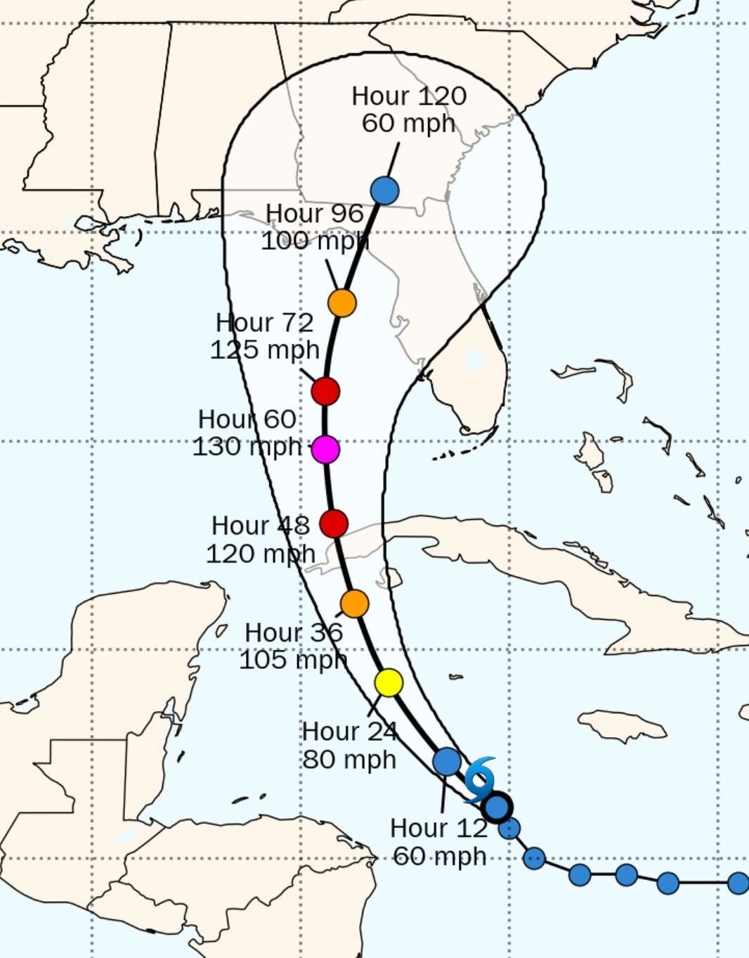
Is it just me or did the euro just initialize a full degree south and 8mb weaker than current position and strength?
-
1
-
-
19 minutes ago, SnowGoose69 said:
The southernmost point camera from Key West people are still standing there as huge waves are coming in
Clearly the big concern is how bad of a hit Florida takes but for us up the east coast the re-emergence and subsequent 2nd landfall has become a real possibility.
Not much unlike Floridas west coast the east coast is also subject to large landfall location shifts by just a few miles of change in track.
Still lots in the longer range to be determined.
-
1
-
-
Little east of due north now as it feels the effects of land
-
EPS should be interesting
-
3 minutes ago, Maestrobjwa said:
How much better, though? Is it that much of a difference?
Yes. A southwest wind funding water into the bay creating a 8+ foot storm surge versus a North East wind blowing water out of the bay. Makes a huge difference.
-
1
-
-
11 minutes ago, TPAwx said:
Euro has landfall near
SarasotaSiesta Key/Venice late WednesdayWould be better for Tampa with that south landfall for storm surge but still a brutal hit.
-
15 minutes ago, AnthonyEC said:
48-60 hours out and there are many solutions still on the table. No clue who will be correct.
Yeah two camps. The slow crawlers up the west side of Florida the ones getting it across and back into the Atlantic. Which one caves?
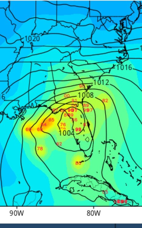
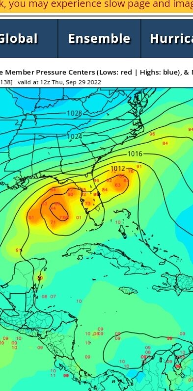
Gefs spread has increased and now has a handful of members off the east coast. This is at 90 hours

-
2 minutes ago, AnthonyEC said:
48-60 hours out and there are many solutions still on the table. No clue who will be correct.
Yeah two camps. The slow crawlers up the west side of Florida the ones getting it across and back into the Atlantic. Which one caves?
-
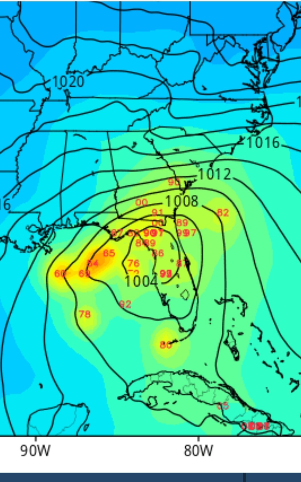
Anyone else seeing due north on sat images? Recon should give us a correct heading but it sure looks north
-
28 minutes ago, TradeWinds said:
NHC and some models hint at a west jog sometime overnight. For now, the storm keeps riding the right side of their cone. Will be curious to see if it wobbles west at some point.

With the big blow up of deep convection just north of the center don't be surprised it if tucks north instead of west.
-
Anyone else seeing this move more NNW recently as well?
-
1 minute ago, GaWx said:
12Z ICON: goes to Jacksonville, which is 100+ miles east of the 6Z and 0Z runs.
Yeah even though it's the icon there is still a very small that the icon and the ukmet and some eps members still float the slim chance this goes off the east coast of Florida or just along the coastline
-
1 minute ago, Hotair said:
18z
So essentially the gefs mean matches that of the eps
-
1
-
-
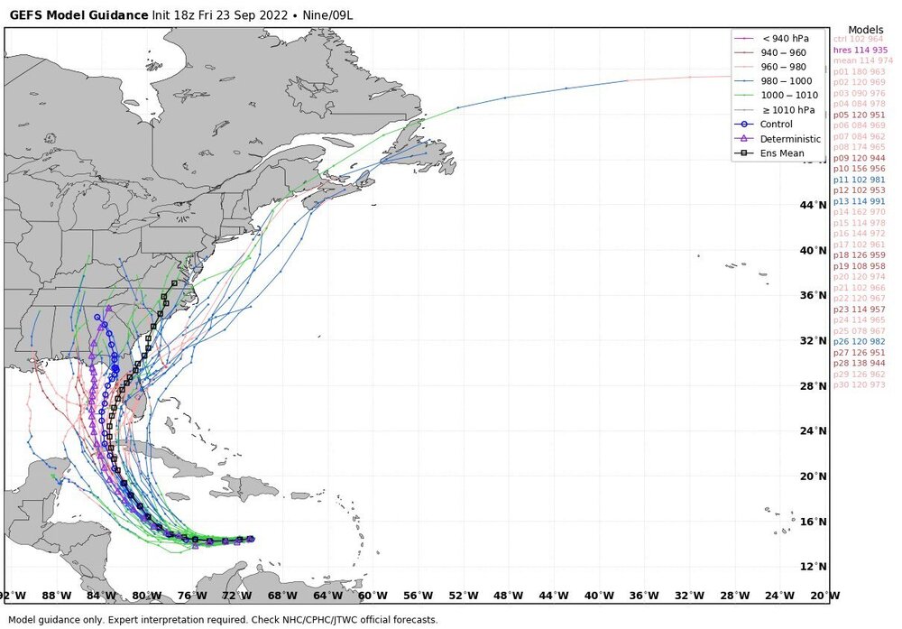
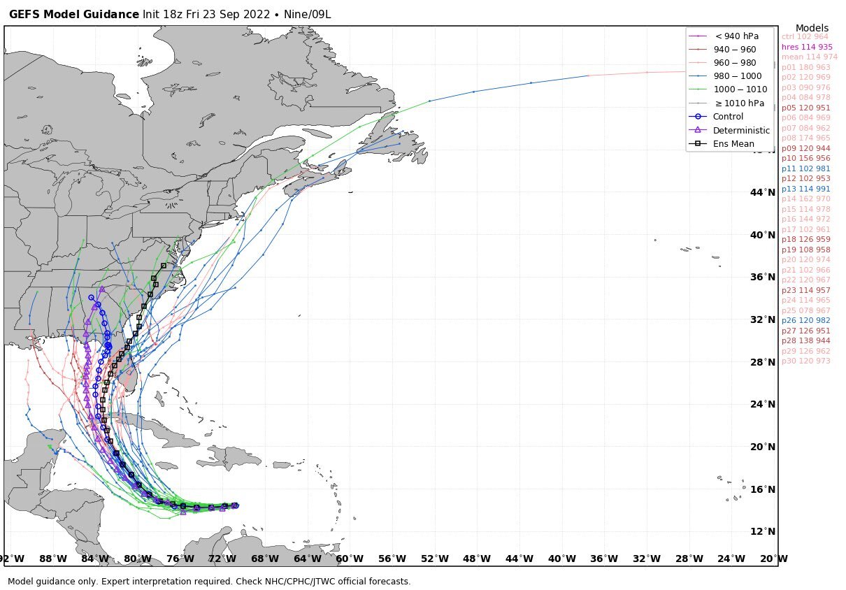
Some gefs members break off and go the way of the euro/eps.
-
3
-
-
11 minutes ago, GaWx said:
The 6Z EPS mean at 144 is a little stronger than the 0Z EPS at 150.
Placement the same?

WPAC, Indian Ocean, and Southern Hemisphere Tropical Cyclones
in Tropical Headquarters
Posted
You can see the mesovrticies already but I imagine when the sun comes up over there it's gonna be spectacular looking eye