

shaggy
-
Posts
7,642 -
Joined
-
Last visited
Content Type
Profiles
Blogs
Forums
American Weather
Media Demo
Store
Gallery
Posts posted by shaggy
-
-
There's a small.village on the south end of a bay that is now in the western eyewall and will soon be in the eye. I'd bet they took a devastating storm surge.
https://www.tropicaltidbits.com/sat/satlooper.php?region=25W&product=vis_swir
-
24 minutes ago, Windspeed said:
Good grief!
Typhoon Kong-Rey is really living up to its name here, folks. The IKE on this thing must be insane. Deep intense ring of convection around a massive 55 nm eye with strong mesovorticies rotating around the inside of the eyewall. The sheer size of the low-level and mid-level vortex combined with such intensity is critical. It's just a different breed of TC in the WPAC, even if the size of this one is still kind of rare to be so strong. It's hard to fathom a TC this large being in the GOM. The storm surge alone would surpass 30 feet along the NGOM coast.

You could fit the entire wind field of Oscar inside the eye of this one
-
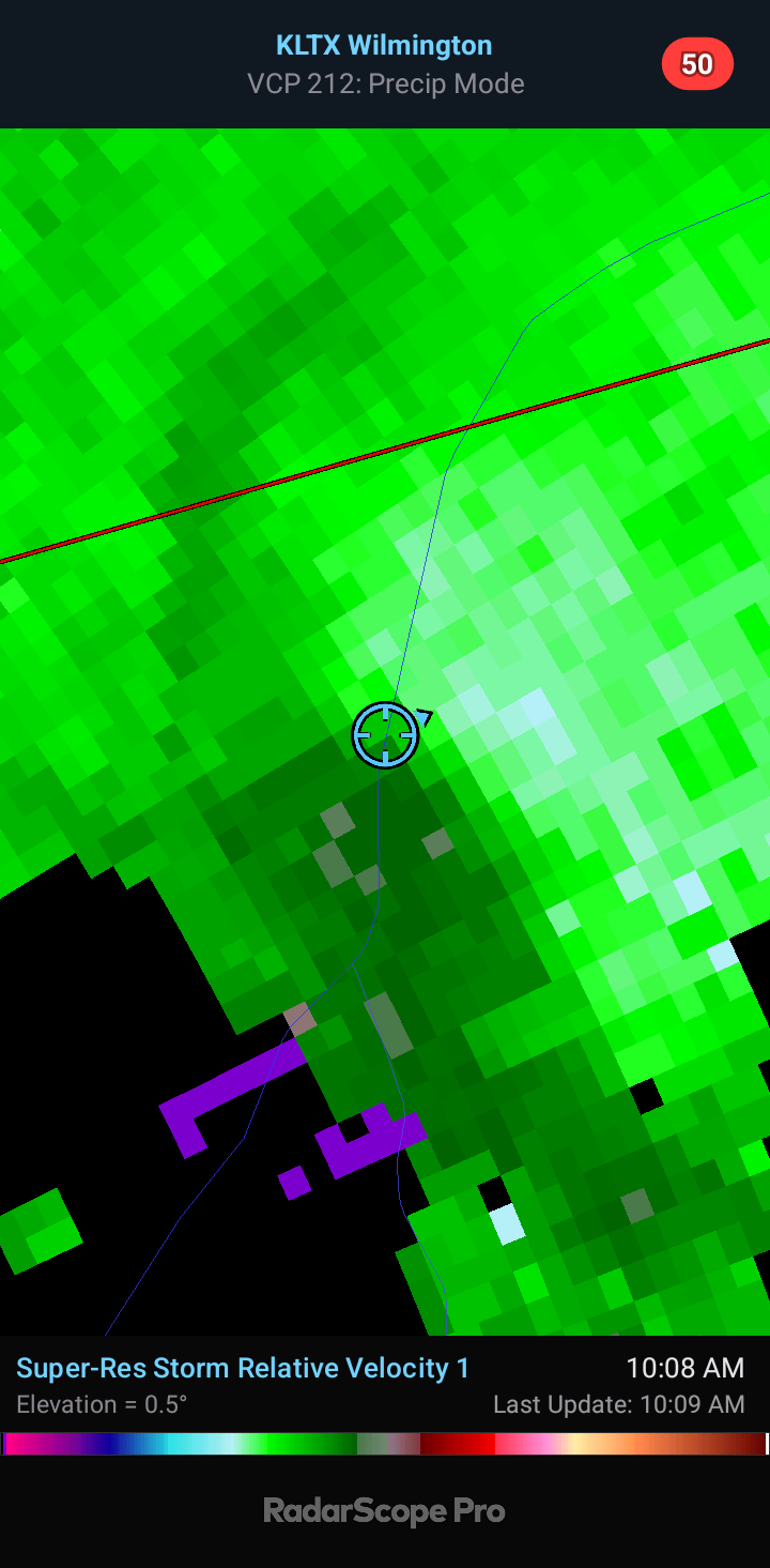
On the coast of NC we had very little weather other than some rotating supercells. This is one I managed to catch about 2 miles from my house. Decent wall cloud and a solid funnel for a weak rotation. It tried hard to put one down but never did I don't think

-
 2
2
-
 1
1
-
-
25 minutes ago, Radtechwxman said:
Real good spin within that area of convection south of Cuba. Curious if that's only a mid level circulation or if we ate getting a low level circulation developing within that area as well.
Sure seems that's the best area of vorticity. It's young and still susceptible to center reformation. If this forms further east towards the cayman Islands we could see some model changes
-
Gefs trending towards euro/ukie/icon
-
2 minutes ago, GaWx said:
12Z UKMET has major changes from prior UK runs:
-much slower movement
-now turns E/ESE to offshore GA/lower SC
-while offshore restrengthens and then turns N with landfall at Georgetown, SC
-moves N into E NC
TROPICAL STORM DEBBY ANALYSED POSITION : 26.5N 84.1W
ATCF IDENTIFIER : AL042024
LEAD CENTRAL MAXIMUM WIND
VERIFYING TIME TIME POSITION PRESSURE (MB) SPEED (KNOTS)
-------------- ---- -------- ------------- -------------
1200UTC 04.08.2024 0 26.5N 84.1W 1001 42
0000UTC 05.08.2024 12 28.3N 84.4W 997 51
1200UTC 05.08.2024 24 29.7N 84.1W 996 40
0000UTC 06.08.2024 36 30.8N 83.6W 1000 32
1200UTC 06.08.2024 48 31.9N 82.5W 1000 39
0000UTC 07.08.2024 60 31.8N 81.7W 997 39
1200UTC 07.08.2024 72 31.4N 79.9W 993 47
0000UTC 08.08.2024 84 31.7N 79.0W 990 46
1200UTC 08.08.2024 96 32.2N 79.0W 988 40
0000UTC 09.08.2024 108 32.7N 79.2W 989 39
1200UTC 09.08.2024 120 33.7N 79.2W 993 42
0000UTC 10.08.2024 132 34.1N 79.2W 996 38
1200UTC 10.08.2024 144 35.7N 78.2W 1001 35
0000UTC 11.08.2024 156 36.7N 76.7W 1003 43
1200UTC 11.08.2024 168 37.3N 73.8W 1002 43Falling in better agreement with the euro
-
3 minutes ago, GaWx said:
12Z GFS once again comes back into GA coast from off the water. However, CMC has caved to normalcy and goes NE up the SE coast. JMA once again does that, too. UKMET and Euro still not out yet.
Gfs is on an island right now. Icon furthest east and strongest. At this point a blend of the ukie/euro/cmc/icon seems reasonable
-
3
-
-
1 minute ago, wthrmn654 said:
It's the red headed step child of a model sometimes. It tries it hardest
It was first with the Texas landfall for Beryl
-
3
-
-
5 minutes ago, NorthHillsWx said:
ICON is a weenie run for a serious storm just pounding the SE NC coast for days
Hoping that's incorrect. It seems overzealous with that much deepening that close to land but it would be a long 2 days for me if it verified
-
3 minutes ago, WxWatcher007 said:
937.3mb extrapolated on that pass
139kt, 149kt, 151kt FL readings
My bet this was a cat 5 after the islands and may still be now
-
4
-
-
19 minutes ago, Winter Wizard said:
Wasn't a perfect environment but it did manage to go far enough south to dodge all the traditional early season barriers, including the area of high shear. Not to mention the consequences of record warm SSTs for this time of year.
We saw crazy pressure falls after the EWRC this morning. Winds responded and the last plane sampled a couple of hours ago and had 150mph cane. It's satellite presentation is impressive and has only gotten much better. The eye is nearly perfect and cleared out. We will likely never know but this is a good candidate to be upped to a cat 5 post-season (unless it's a cat 5 when next recon goes in).
-
2
-
-
4 minutes ago, GaWx said:
Thankfully it is moving along at a pretty fast clip of 20 mph thus shortening the duration of effects on the Windwards somewhat vs what would have occurred with slower movement.
6mb drop between passes and it was at 150mph......question is did that represent the winds had already caught up to pressure falls or do we see this make a run a cat 5?
-
Next pass coming up. Should be final pass before it passes the islands
-
Some crazy winds on that last pass. May make a run at 150+
-
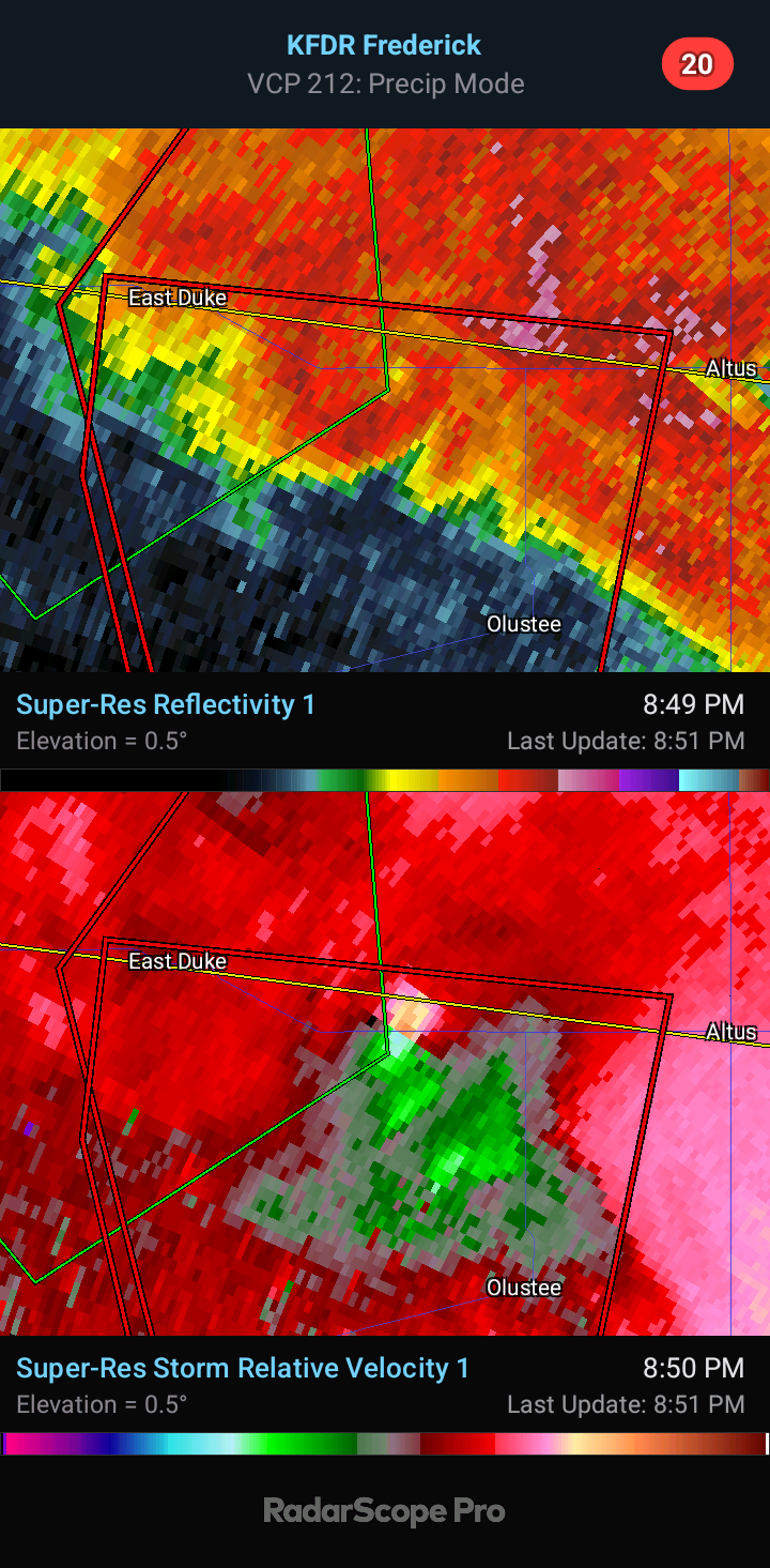
26 minutes ago, Chinook said:
possible large tornado near Silverton TX
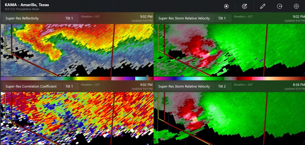
winds up to 97mph in Nebraska
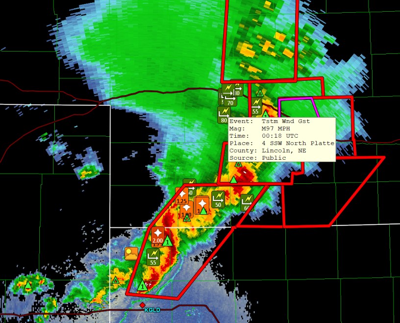
Reed was all over it. Big stovepipe but he blew his car up and the chase is over but the cell is still going strong.
-
Some crazy video of Dawson Springs area tornado
-
1
-
-
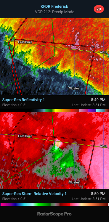
Nice donut hole before it occluded
-
22 minutes ago, Chinook said:
some of the higher velocities I've seen
There have been several very high end tornados this year
-
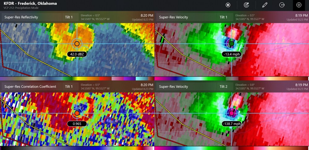
22 minutes ago, outflow said:
Reading the abovd The Elie tornado comes to mind as a small in size but with upper end strength.
The pressure gradient must have been insane for such a narrow tornado to have winds 200mph just 140 feet off the ground
-
-
DOW recorded winds over 200mph with the greenfield tornado
-
9 hours ago, andyhb said:
Also on Freddy McKinney's live stream. 6 of the last 7 days have had tornadoes now.
I think he took it down but was watching when he transported that wounded family to the hospital. That was tough to listen to. I bet his adrenaline was through the roof.
-
Might be one of the biggest pressure drops in history. Anyone have the stats on that?
-
1
-
-
1 hour ago, NorthHillsWx said:
That’s an incredible stat for both basins
The ATL has had its fair share of majors as well


WPAC, Indian Ocean, and Southern Hemisphere Tropical Cyclones
in Tropical Headquarters
Posted
Solid bout of RI for Chido in the SW Indian ocean. Very impressive cyclone
https://www.tropicaltidbits.com/sat/satlooper.php?region=04S&product=ir