WXMan42711
-
Posts
106 -
Joined
-
Last visited
Content Type
Profiles
Blogs
Forums
American Weather
Media Demo
Store
Gallery
Everything posted by WXMan42711
-
Severe Weather Statement National Weather Service Little Rock AR 813 PM CDT Mon Apr 11 2022 ARC045-085-119-120145- /O.CON.KLZK.TO.W.0041.000000T0000Z-220412T0145Z/ Lonoke AR-Faulkner AR-Pulaski AR- 813 PM CDT Mon Apr 11 2022 ...TORNADO EMERGENCY FOR CATO...GIBSON...OLMSTEAD...MACON...LITTLE ROCK AIR FORCE BASE... ...A TORNADO WARNING REMAINS IN EFFECT UNTIL 845 PM CDT FOR NORTHWESTERN LONOKE...SOUTHEASTERN FAULKNER AND NORTHEASTERN PULASKI COUNTIES... At 811 PM CDT, a confirmed large and destructive tornado was located near Olmstead, or 8 miles west of Little Rock AFB, moving east at 35 mph. TORNADO EMERGENCY for CATO...GIBSON...OLMSTEAD...MACON...LITTLE ROCK AIR FORCE BASE!. This is a PARTICULARLY DANGEROUS SITUATION. TAKE COVER NOW!
-
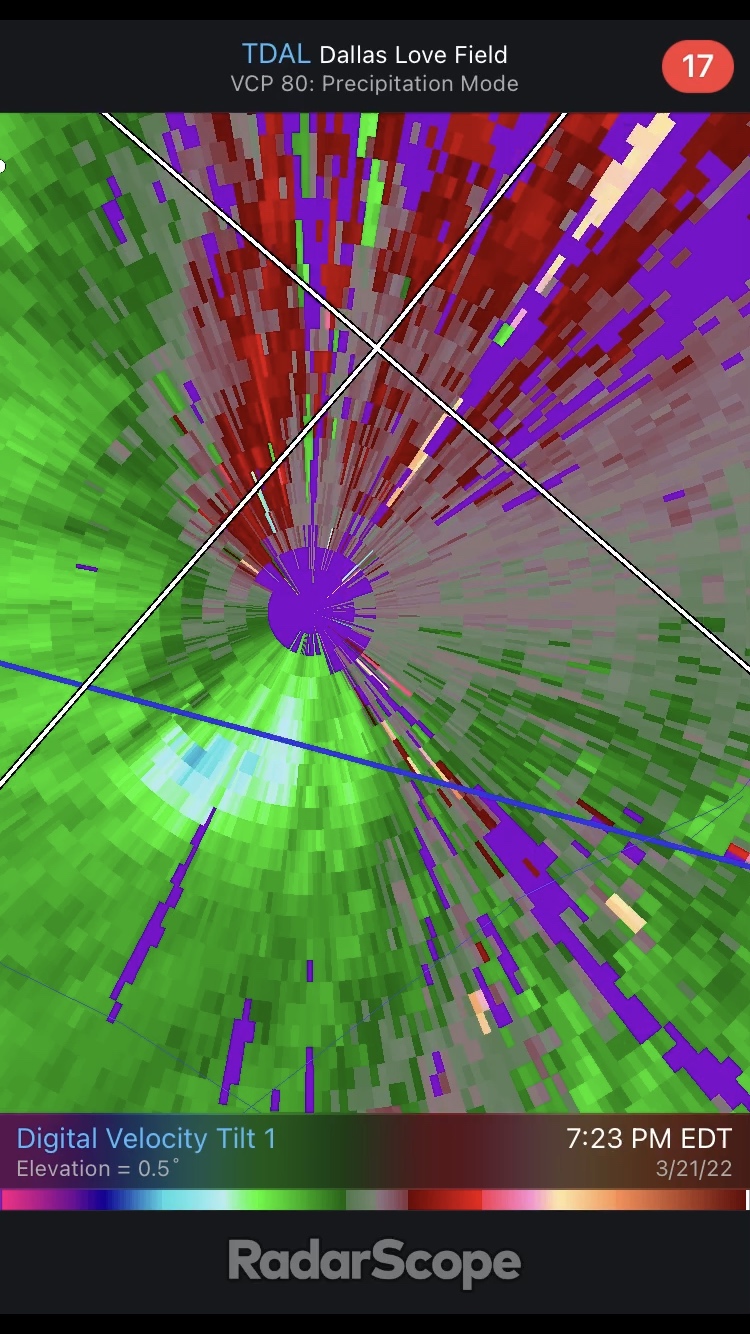
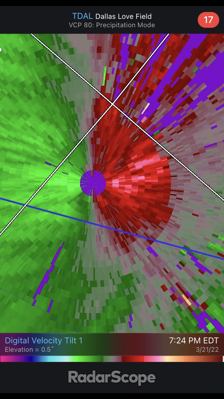
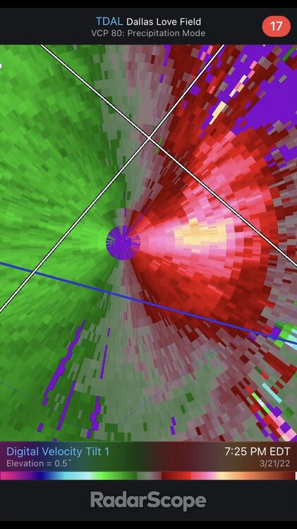
TDAL just took a direct hit as well


-
hard to believe it was only 30 minutes ago that the biggest concern was a lone tornado hitting austin. there is a lot going on at the moment.
-
i know sometimes the radarscope/radar programs don't update in a timely manner, but not this time... the tornado was first shown on KXAN at 5:57pm CDT and the warning bulletin was issued at 5:59pm CDT. yikes.
-
insane live footage of tornado ongoing near round rock, TX
-
just showed a live tornado cross i-35. it is out of frame but it was close enough to see the funnel and lots of debris https://www.kxan.com/live-stream/
-
for anyone looking for coverage as this moves into Austin, TX: https://www.kxan.com/live-stream/
-
down here in cincinnati, we are in a weird middle ground of getting ~0.25" of ice and then potentially 4"+ of snow by the end of this event.
-
Current running total of deaths, with links to verification:Western Tennessee - 3Edwardsville, Illinois - 2Bowling Green, Kentucky - "multiple", but no number givenMayfield, Kentucky - between 50 and 70Bremen, Kentucky - 11Dawson Springs, Kentucky - no number given, but deaths reportedMonette, Arkansas - 5 Defiance, Missouri - 1
-
unbelievable. terrifying and now i understand why at least 50 are feared dead.
-
this thing still, and i literally mean still as of 1:20am EDT, has a debris ball on it. just a beast of a storm.
-
the nati gets in on the action
-
was just wondering this myself. wow. this storm would be impressive in april or may. the fact that it has occurred in december is surreal. it has maintained that classic supercell look for about thirty mins now.
-
nws in stl has taken shelter BULLETIN - IMMEDIATE BROADCAST REQUESTED Severe Thunderstorm Warning National Weather Service ST LOUIS MO Issued by National Weather Service Kansas City/Pleasant Hill MO 749 PM CST Fri Dec 10 2021 The National Weather Service in ST LOUIS has issued a * Severe Thunderstorm Warning for... Southern Crawford County in east central Missouri... Southwestern Washington County in east central Missouri... * Until 815 PM CST.
-
tds west of the stl metro
-
Oct. 23-25 Severe/Heavy Rain (especially Sunday)
WXMan42711 replied to Tim from Springfield (IL)'s topic in Lakes/Ohio Valley
two strong tornadoes ongoing right now
-
who is awake
-
Severe Weather October 10th-12th 2021
WXMan42711 replied to Sydney Claridge's topic in Central/Western States
surprisingly quiet in here for something that, at its surface, looks like a noteworthy day/evening ahead. thoughts on the setup? -
small tds over virgil
-
starting to see storms fire southwest of these in central indiana. they’re heading my way and will have a lot of humid air & sunlight to work with when they get here.
-
possible big tornado about to crossover indiana into ohio
-
Severe Weather May 26th- 28th 2021
WXMan42711 replied to weatherextreme's topic in Central/Western States
some spin ups still ongoing at this hour -
Severe Weather May 26th- 28th 2021
WXMan42711 replied to weatherextreme's topic in Central/Western States
interesting -
the tds on reflectivity was huge. they don’t usually get that big on reflectivity. scary situation unfolding.