

TSG
-
Posts
476 -
Joined
-
Last visited
Content Type
Profiles
Blogs
Forums
American Weather
Media Demo
Store
Gallery
Posts posted by TSG
-
-
Heavy rain and lots of CG lightning with this complex that's been sitting over Albemarle the last hour. Starting to get nervous with that line to my north really solidifying and picking up speed..
-
WOW @ the last few scans. Radar lighting up across central VA/southern MD
-
Epic writeup. I knew a lot of this but seeing it so well laid out is nice. Saving to share with others!
-
 1
1
-
-
9 hours ago, WEATHER53 said:
Wow
That first of June torrid streak 2011 (I think) they did hit in advance but departing highs just aren’t setting up over Bermuda so far. They are weak also, not 30.30+ that nothing can budge for long time.
I'll never forget that week. It was gnarly being outside. I was working at a summer sailing camp on the Potomac and we were gathering kids up and spraying them down (and ourselves) with the boat washing hoses to keep cool.
-
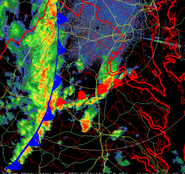
Radar looking really bad over 64 right now. Hook echo now clearly visible. Lots of rotation..
-
 1
1
-
-
That large cell WSW of Richmond has been going since 4:45pm when it was coming off the Blue Ridge West of Charlottesville. Impressive echo tops, over 50k ft now. I got to watch it march into the Piedmont from the reservoir.
-
1
-
-
The section of the large line to the south that came through downtown Charlottesville was legit. Didn't see any hail but winds were easily gusting to 60+, rain going sideways, stormwater infrastructure quickly overloaded. Looks like CHO didn't get hit as hard based on the 5-min obs.
Best storm of the year so far.
-
1
-
-
some sort of triple point visible on radar? What's going on SE of CHO?
There's pretty clearly some kind of warm boundary stretching across VA. Made a drawing to show what I'm talking about.
-
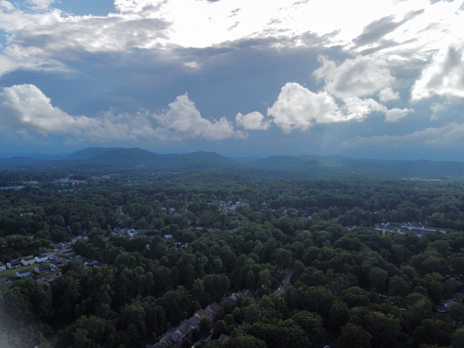
From my place south of downtown Charlottesville about 20 mins ago. Images are a bit blurry because of the compression.
Looking SW

Looking South
-
5
-
-
~40k ft cloud tops on a couple of those cells south of CHO
-
1
-
-
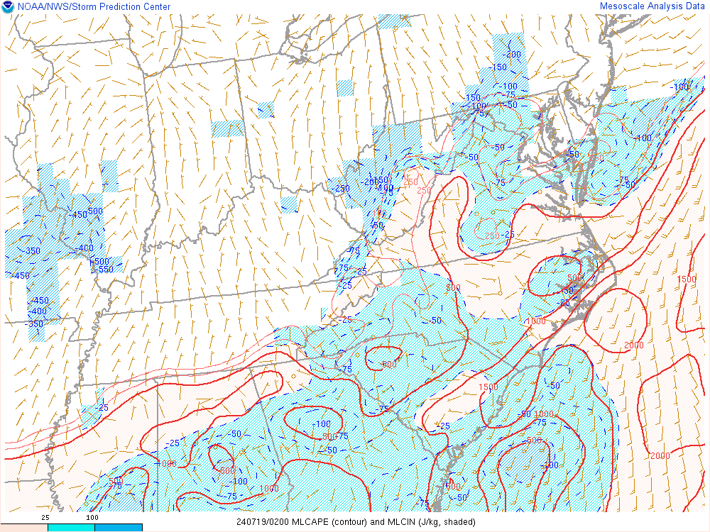
Latest SPC mesoanalysis has Cville back over 1500 J/kg of SBCAPE, with the 2000 line not far off.
That seems like enough to work with.

MLCAPE not nearly as robust, but it is changing quickly.
-
I'm thinking we have a solid chance at round two down this way. Sun is poking out and the air feels thick. We're up to 75/66 after dropping to 66/63 around 10:30am this morning during the heavy stuff.
-
2
-
-
20 minutes ago, snowfan said:
GFS is a step in the right direction for the weekend. Front clears overnight Friday.
only a minor adjustment...
.thumb.gif.e4122c62b35fac8272289be972d03252.gif)
-
3 hours ago, Maestrobjwa said:
I would like to see a chart of how many warning events happened at BWI during ninas vs other enso states. I'll bet the other states have more...lol
If I'm wrong about this...why shouldn't I put a ton of weight on what I've seen since 2016? Too small of a sample size? I mean I've tracked 4 and not 5 Ninas and honestly I haven't seen any difference in how they've behaved!
Yes. Your back yard is also not representative of overall patterns. No offense intended... but you can't tell a difference because you aren't looking at the right things. How much snow a little postage stamp of land south of Baltimore has gotten the past few winters is not a useful datapoint.
-
2
-
-
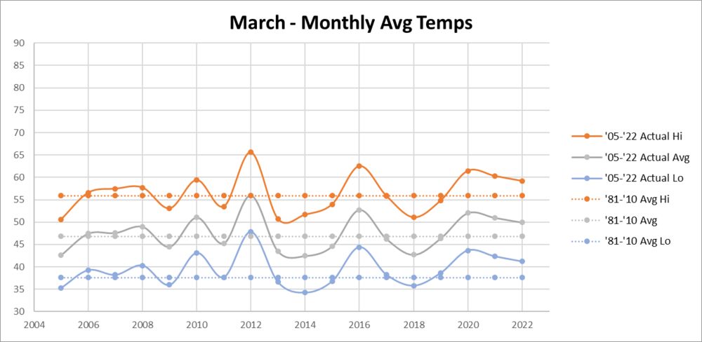
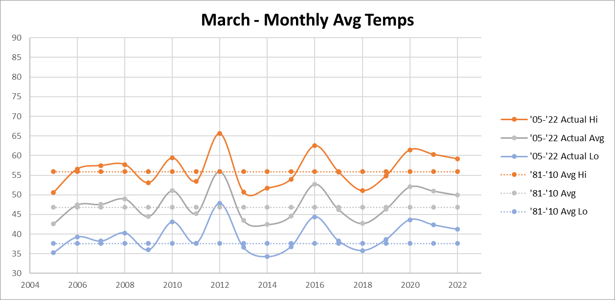
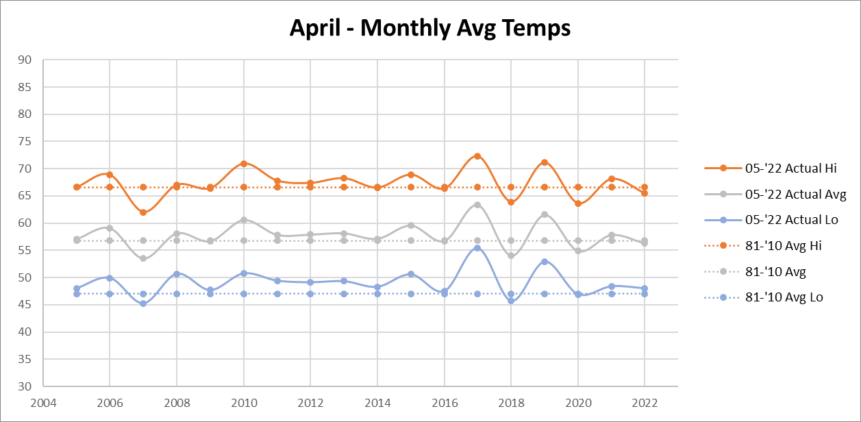
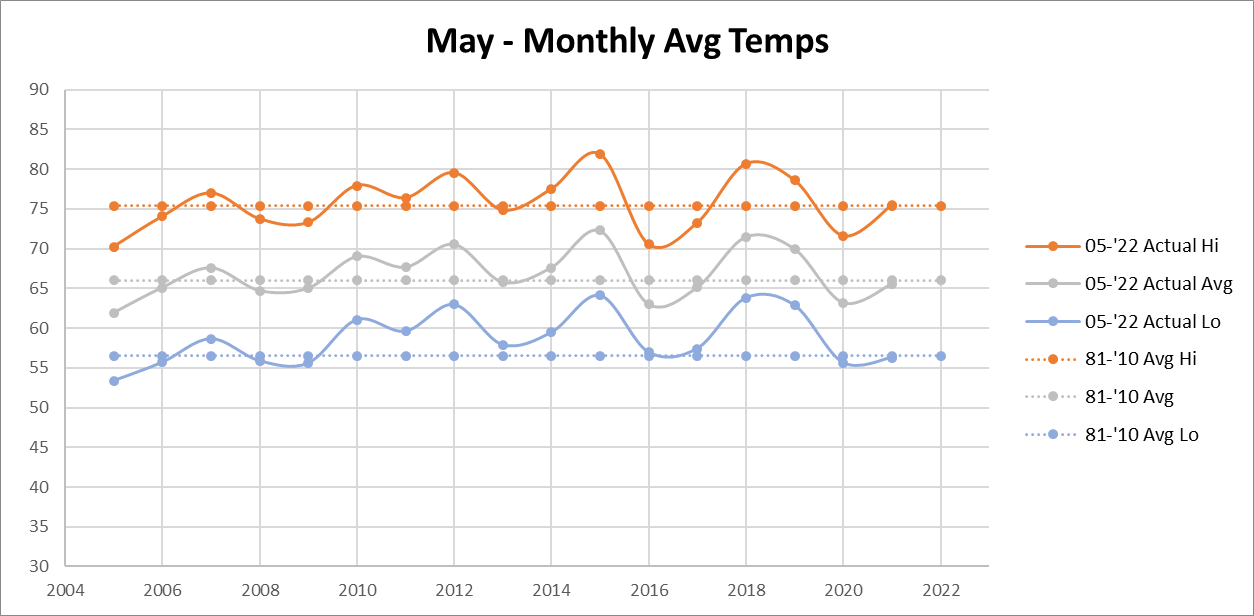
@Maestrobjwa I got thinking about this some more and I think it's important to remember we are humans with subconscious bits of our memory that influence how things feel. This year and the past two we've had above normal March temps followed by avg or slightly negative departures in April and May (20/21). In my mind this would tend to "feel" like a cold spring, especially if those warm March avg temps were brought on by a few key warm stretches towards the end of the month and not a general slightly above average regime. To have that then be followed up by weeks and weeks of the same temps would feel "cold" even if it's about average.
2018 is also in recent memory which is pretty much the coldest early spring we've had in the past 2 decades. May obviously bucked the trend that year but the memory was made at that point.
My guess is those two things make the past few years seem out of place.
-
2 hours ago, Maestrobjwa said:
Niiiiice!! That's pretty awesome! And I'm sure this has been discussed and debated much lately, but...man I still don't remember mid-Arpil/early Mays being as cold as the last 4-5 years! But perhaps it's just recency bias? (Not that I'm complaining...heat and especially humidity can wait however long, lol)
15 minutes ago, WxUSAF said:Going back to 2016, it’s about 50/50 on AN or BN for April and May combined at BWI. There have been some anomalous spring -NAO periods though in there.
Slow day at work. Made some graphs. Data is from DCA


-
3
-
4
-
-
4 minutes ago, Maestrobjwa said:
I'm telling ya if we get a 3rd consecutive nina...it might be the longest big snow drought since the 70s. Well, for my yard anyway....Some of you tried to tell me before this winter began that I was jumping the gun...but lo and behold look what happened! Busy NS train of vorts with no space, coastal scraper benefiting CAPE and other beaches...textbook. Exactly the kind of thing I expected going in. Forgive me if I'm not convinced ninas won't behave differently.
But I suppose it's still better than no snow at all...not many ninas are complete shutouts. It's just...ya still want a little more SOMETIME.
back away from the edge bud, it's mid-April
-
1 hour ago, Cobalt said:

THE VILLAGE!! This pic just made my day. I'm a 2014 grad, lived in Eagle.
-
1
-
-
My coworker up in the valley near Staunton has SN/SN+ coming down
-
Wow it is miserable in Cville. I think we're all or mostly rain at this point but the temp was 40 when I left for work and has only gone down.
35/34 at 11:30
-
1
-
-
Distant thunder and a quick downpour in Lake Barcroft. Radar looked much more intense than the ground truth.
-
6 hours ago, kgottwald said:
Well, we usually get extended stretches of nice weather in the fall, except when tropical storms affect the area. October is almost always our sunniest month.
October is by far my favorite month in the mid-atlantic, especially the first half. Humidity starts drying up but we still regularly get into the 70s mid-day.
It's a annual glimpse of what summer is like in Northern New England
-
2
-
-
Sun poking through in Charlottesville. Wasn't expecting this ahead of the last line.
-
1 hour ago, NorthArlington101 said:
You jinxed it - climbed up to near 50 on-Grounds.I forgot how dry the air is right now. It's going to be fun to watch the temp drop after sunset

.gif.ea68cd983eeb2e5e5611eba2b4cffdd9.gif)
2022 Mid-Atlantic Severe Wx Thread (General Discussion Etc)
in Mid Atlantic
Posted
I swear the dog-leg turn in the Potomac causes things to spin up down there more than normal. Anyone know if this has ever been looked into?