

TSG
-
Posts
692 -
Joined
-
Last visited
Content Type
Profiles
Blogs
Forums
American Weather
Media Demo
Store
Gallery
Posts posted by TSG
-
-
26 minutes ago, smokeybandit said:
After 15 years living in the DMV, now 5 years living in the high plains desert in Colorado, I am not looking forward to all that humidity when I fly in tomorrow.
It's been impressively humid. I haven't seen the DP much below 70 for about two weeks now
-
2 hours ago, TheClimateChanger said:
With that said, still a far cry from the olden days of the 2010s, when DCA would far outpace all other sites in the CWA not named "Maryland Science Center." Looks like they got most of that so-called UHI in check at National Airport. At the height of its urban heating days, in 2015, it was 1.5F warmer than any other site. Even beating DMH by 1.8F. With the 2015 sensor in place, would probably be making a run for record warmest.

2025

2010

2015

Idk if all of that can be assumed from that data.. too far apart geographically for those temperature deltas to be attributable to ONLY the sensor accuracy and/or local environment effects. The weather in Baltimore (MD Science Center) and DC could be very different (or anywhere else for that matter). Especially in a month where backdoor fronts can easily cause a 30 degree temperature delta between NoVA and the M/D line.
You need to be looking at other stations within like 5 miles of DCA to make that comparison mean much
-
brief echo tops around 55-60k ft on that cell West of Carlisle, PA
-
 1
1
-
-
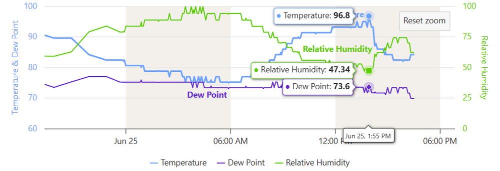
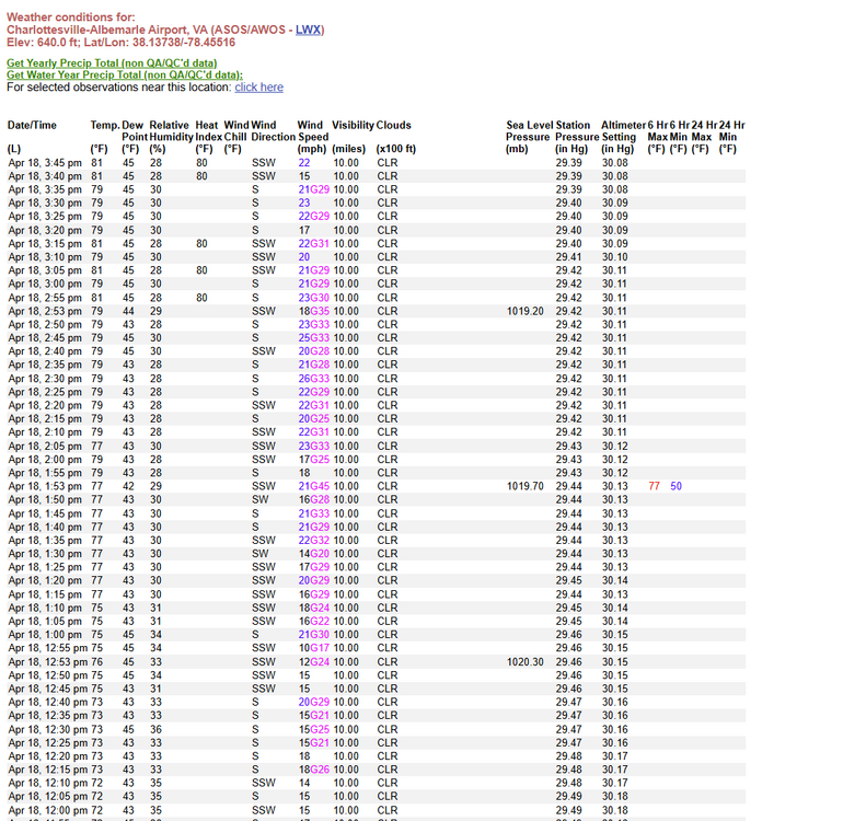
Interesting afternoon down this way. CHO was well on it's way to 100 it seemed but the storms that popped early over Madison and Orange counties sent a bunch of outflow and high level clouds out to the SW. We've been in the mid 80s since ~2:30 because of it despite zero precip
-
Downtown Charlottesville hit 100 right around 4:15, back to 99 now. (WVIR Earth Networks Station)
Temps outside of town hovered around 95-96 most of the afternoon.
CHO's garbage weather station hasn't reported since 2:05pm.... right in the middle of a significant weather event again. It's like they do it on purpose, it's honestly baffling how often that station goes offline.
-
1
-
-
2 hours ago, wxdude64 said:
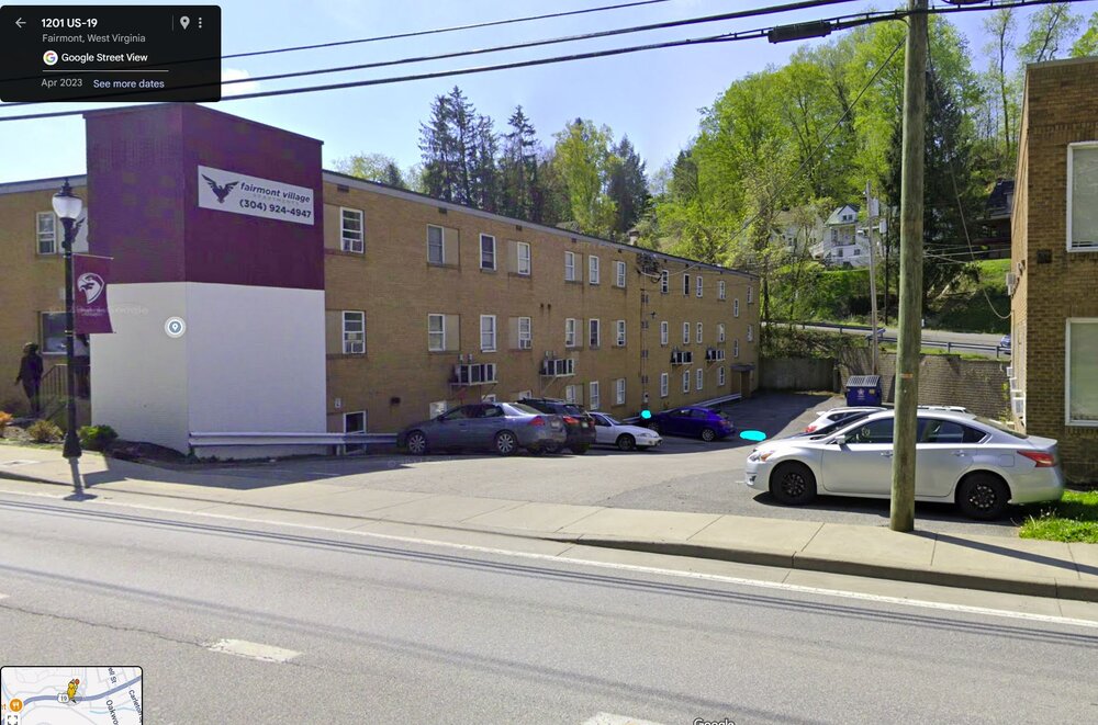
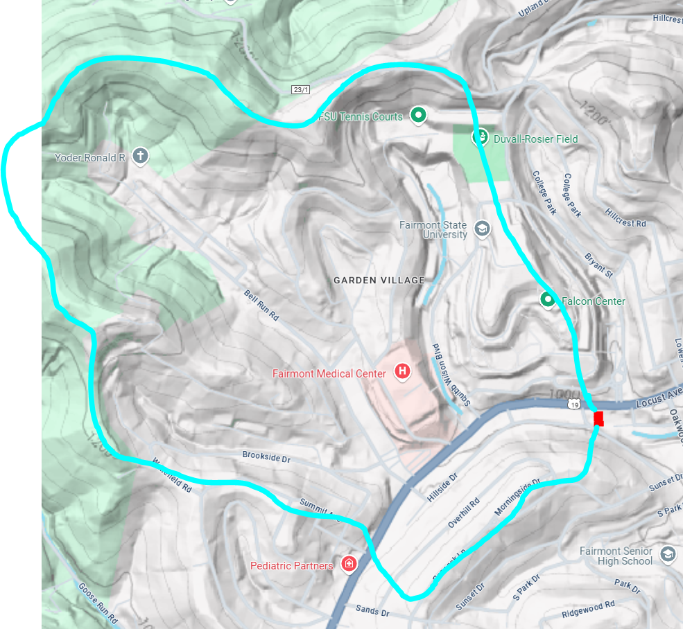
Looks like that building was basically a 'dam' with water going thru the windows AND not sure if that was flood water or coming from another source, over the roof at one point, crazy!
I was curious about that as well so went and snooped around in Google Maps. Seems like the stuff coming off the roof was just from the roof itself sending all rainwater to the new low spot after the wall failed. This is a pretty good example of older construction that likely wouldn't get permitted today (at least not in VA). You're right that the building was effectively a dam... look at where it's located in the local landscape.
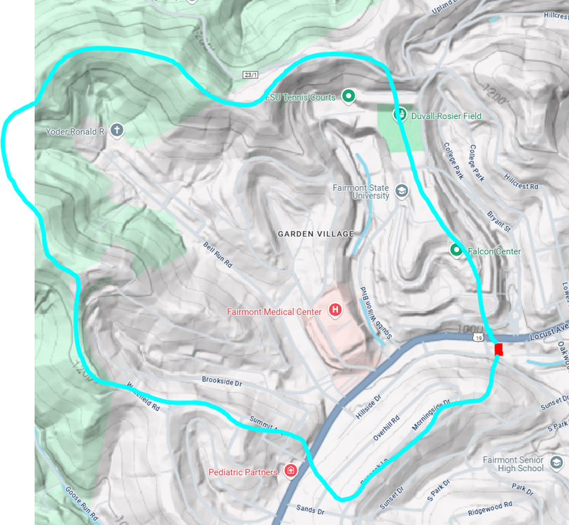
Red = apartment building, Teal = drainage area
The uphill side is basically a swimming pool too, with the curb likely not high enough to contain the water in the street from spilling over. Drainage for the lot seems to be a grate drain (teal rectangle) and an ~18" overflow pipe (teal dot) going under/through the building. Both could have been partially clogged, especially the grate. Really poor civil design here overall.
-
1
-
 2
2
-
-
3 hours ago, WxUSAF said:
Yeah I’m selling on 104-106. 100 though seems possible
My memory from the last few summers is most models have been overdoing high temps in the med/long range. I'm guessing we top out around 96-100F for most of the area.
-
2
-
-
I gave in, I turned my heat on.
54/53 with mist and fog in hooville
-
One of the nicest looking forecasts I can recall in recent memory. Heavenly
Currently 65/55 under full sun. Picked up another 0.34" overnight.
-
7
-
-
53 minutes ago, 87storms said:
Yuck. Hope that's wrong.
Really?? I'll gladly take another few weeks with highs in the 70s
-
5
-
 2
2
-
-
2 hours ago, Eskimo Joe said:
Close to 1300 w/m^2 solar radiation today statewide. Solar panels are probably cooking good.
Wow. That's exceptionally high. Irradiance at the top of the atmosphere is roughly 1360. That's usually whittled down to around 1000-1100 due to humidity, aerosols, etc
-
It was so damn windy the annual Rappahanock Rivah Regatta had to stay off the water today. Sailboats. Too much wind in late May... when we're almost always concerned with too little. Lol
-
29 minutes ago, MN Transplant said:
Better now?
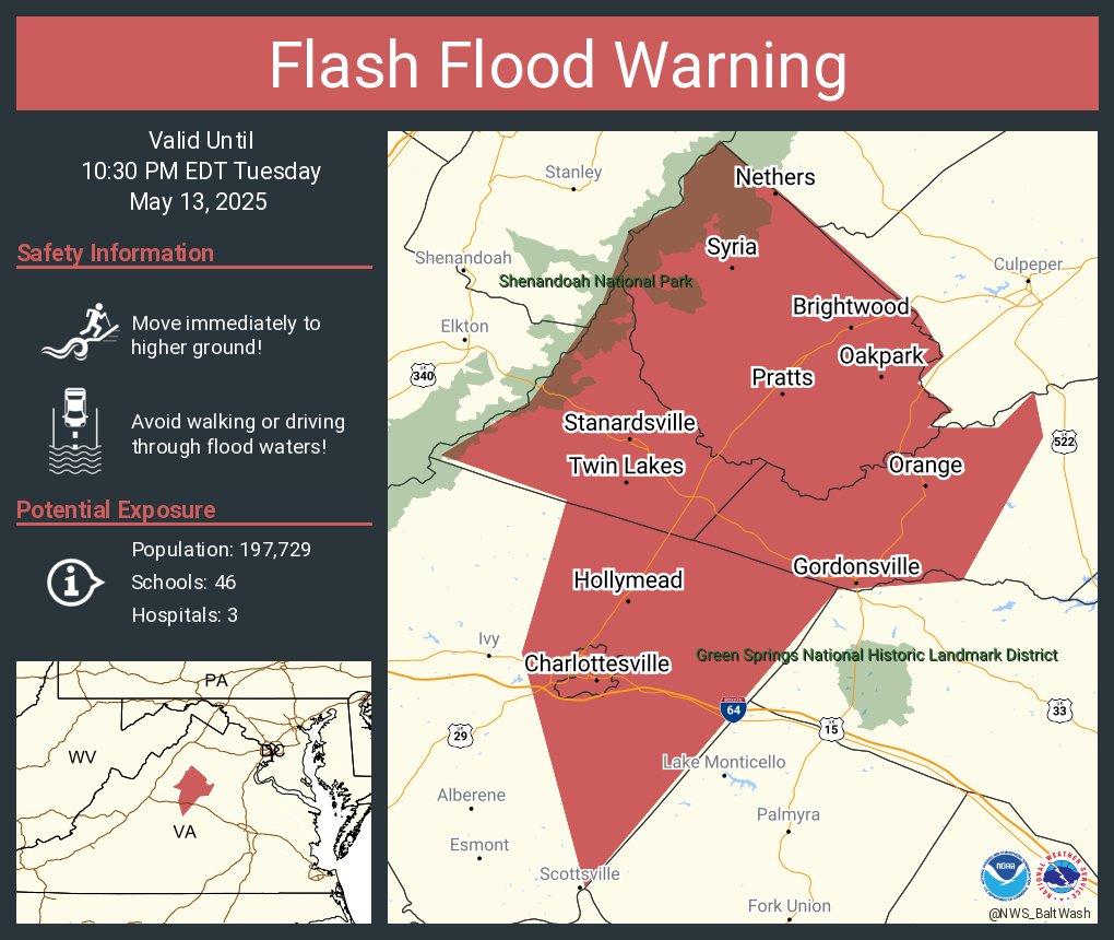
lol, things turned around quickly this evening. FFW warning through 10:30pm. Up to 1.24" at CHO
-
1
-
-
only 0.26" at CHO and we've got sun trying to peak through now

-
1 minute ago, nj2va said:
10/10 day and 11/10 right now.
Got a solid first burn of the year walking around on a landfill and some cattle pasture in Albemarle today.
Windows open now. Sucks that we're so dry but I don't hate this SoCal weather
-
1
-
-
Maybe the windiest day yet down this way. Pollen apocalypse out there. My eyes are dying
-
5 minutes ago, George BM said:
March 2nd, 2018 was epic.
The skylight cover/window over the stairwell in my row house in DC was lifted off the building and disappeared into the sky that day. Pretty sure the pressure differential between inside and out during one of the gusts is what popped it free. Epic indeed.
-
2
-
-
this board's negative feelings about wind will never fail to amuse me. I love it. I wish we had more days like this
-
1
-
 1
1
-
-
54 minutes ago, IronTy said:
DOGE must've known. We don't need any of that NOAA overhead apparently. Hopefully the new AI will forecast at least 60" storms for us perennially at d10. That would be cool.
https://au.finance.yahoo.com/news/ai-breakthrough-offers-weather-forecast-161544914.html
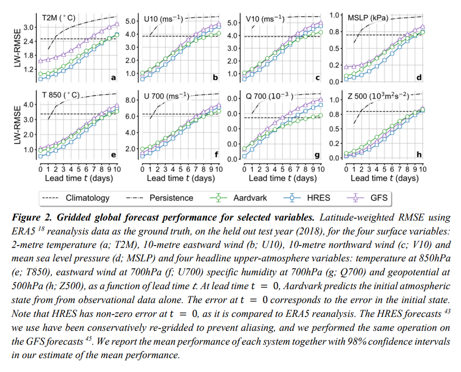
Tests of the Aardvark model revealed that it is able to outperform the United States national GFS forecasting system using just 10 per cent of the input data, leading researchers to say it could offer a “revolution in forecasting”.
Not trying to be mean here but that article is trash. "10 times better?" Over what time scale? what variables? wtf does better even mean in this context? nothing is explained. That's an AI hype piece masked as a "the revolution is here!" feel good story
Their "revolutionary" model has slightly lower RMSE values when compared to the GFS in most areas. It also runs at a 1.5 degree (~110 miles) horizontal resolution compared to the GFS's 0.25 (17.4 miles) or the ECMWF HRES's 0.1 (5.5 miles). Vertically it's also nothing close. The GFS divides the surface to the mesopause into 127 layers. The ECMWF has 137 layers. This AI model has 5. It's providing orders of magnitude less information about the atmosphere, and it's only slightly more accurate at the points it does forecast.
Actual Study: https://cdn.roxhillmedia.com/production/email/attachment/1700001_1710000/865aa96b274c128474186cf6f77b2556fe008b92.pdf
-
5
-
3
-
-
2 hours ago, WEATHER53 said:
He likes the melodrama of storming off
Who offended his precious models this time?
"Pot, meet kettle."
-
1
-
1
-
-
-
4 hours ago, spud said:
Hi! Long time lurker here. I have a snowball that has been in my freezer since 12/25/2002. My daughter made it and it seemed like a great thing to save at the time. She is all grown up with her own kids and surprisingly doesn’t want it, lol. Sooo, is there any science or other reason to save this? It was a great looking snowball one time.

From the science perspective, that likely contains very high NOx and SO2 particulates compared to current levels. Peak poor air quality (from those two offenders) was around 97/98. NOx dropped off quickly after 2000 and SO2 was only a few years behind. We're down about 90% on those emissions since 1995.
Some environmental researcher may be mildly interested.
-
2
-
1
-
-
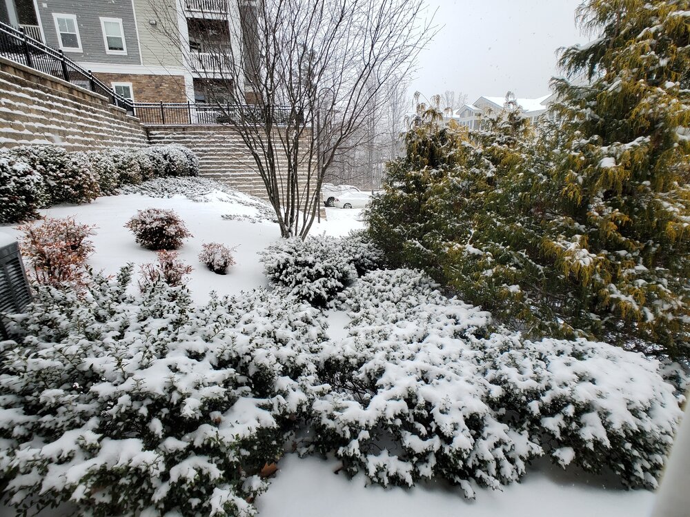
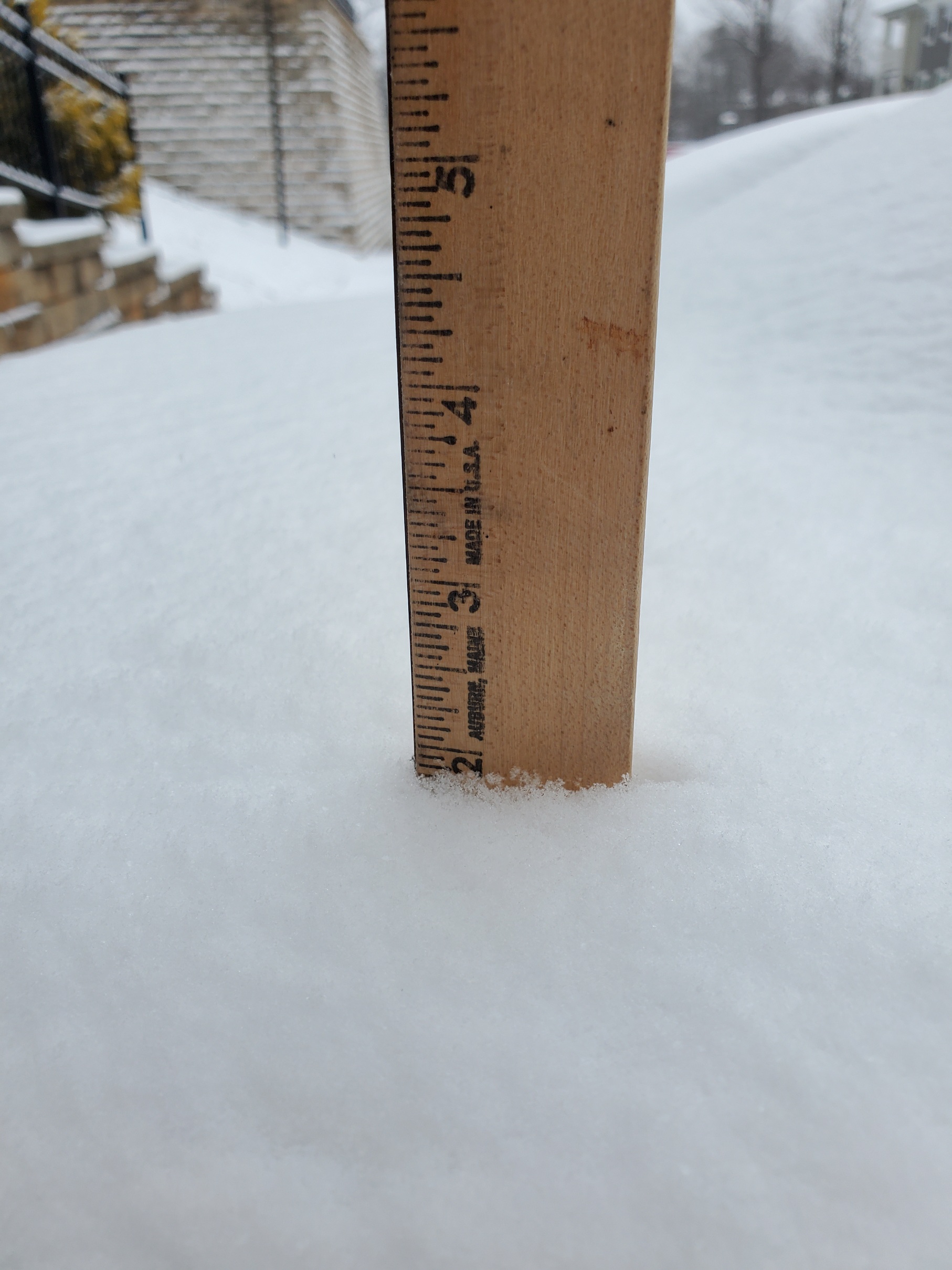
Just about done here. One of the most visually impactful 2" storms in recent memory

-
11
-
-
Back end approaching quick down this way. This may end up my 2nd favorite event this year due to the temps. I honestly prefer a frigid 2-3" over a sloppy 6-8" type deal like we had last week.
-
14
-


July Discobs 2025
in Mid Atlantic
Posted
this would get more traction in the Philly subforum. We cut off hard at the M-D line in here, only a handful of regular posters north of that