

TSG
-
Posts
476 -
Joined
-
Last visited
Content Type
Profiles
Blogs
Forums
American Weather
Media Demo
Store
Gallery
Posts posted by TSG
-
-
Yeah the geographic boundaries for subforums work, but telling some guy to **** off back to the Philly subforum when he lives 10 miles off the MD/PA border is just mean and pointless. In an era of dying online forums this is entirely the wrong attitude to have.
-
 1
1
-
-
5 minutes ago, mappy said:
Still missing the point. It’s not our subforum
You're going against your own logic from 3 posts back. I don't have any skin in this game but it's kind of obnoxious to see from a moderator
-
 1
1
-
 1
1
-
-
9 minutes ago, mappy said:
If someone from New Freedom or Shrewsbury want to share an observation here, fine. That’s just on the other side of the MD line and I’d appreciate it as a northerner. But Chester County? Harrisburg? No way. Go north to your subforum please
Chester County touches MD. If you're willing to take obs from Shrewbury/New Freedom why wouldn't the same logic be applied to the whole southern PA border along our "subforum"?
-
2
-
-
Looking for home weather station recs in the $150-250 range. Is Ambient Weather still good quality?
-
11 minutes ago, WxUSAF said:
The blinds have been opening and closing with lightning speed
-
2
-
13
-
-
11 minutes ago, MDScienceTeacher said:
TT only goes back 7 days.. but it nailed it in the 7 day window:
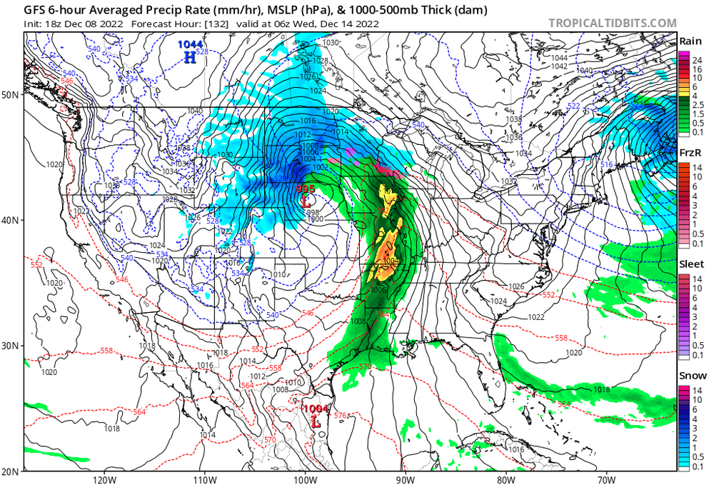
Not quite. It had the idea on that run but the next day (dec 9th) we got like 3 runs in a row showing snow/frozen for central VA and north, followed by 2 or 3 showing suppression with us maybe getting some flurries.
It didn't "lock in" on the correct solution until 12z on the 10th. So about 4-5 days.
-
1
-
-
37 minutes ago, Kleimax said:
Noob question here please don’t roast me, but why do the higher elevations stay colder longer? I thought “cold air sinks” and “heat rises”, so shouldn’t the lower elevations stay colder than the mountains?
Adding to what Mappy and PSU already said, if you check out the 3k NAM at the onset of precip you can get some clues there. The peaks along the Blue Ridge for example are only a couple degrees colder than the valley (Staunton/Harrisonburg area), but that's enough to have a large difference. Ice will barely accrete right at 32 degrees, you get closer to the upper 20s and it's a very different story. Later on when the warm nose does finally push through at ~925mb, the ridges and valley all switch over to rain around the same time.
TL;DR: In this specific setup the high elevations accrete more ice because of conditions at the start, not because they hold onto the cold air longer.
Thats also a large part of why these marginal events are so hard to forecast. Small temp swings can make for large changes in precip type/duration.
-
1
-
1
-
-
4 minutes ago, ldub23 said:
is a western trof as shown at 384 the key to a cold snowy east? I would argue it is not ideal.
I would argue you don't have a clue what you're talking about
-
1
-
-
2 hours ago, pazzo83 said:
yeah it's pretty common for there to be snow up there and "white rain" downtown.
looks like DCA got down to 33F - 34F downtown here.
Yup, saw this all the time when I lived in AdMo/Woodley Park (roughly 175' asl) and worked on L St. Lots of marginal events where I walked to work in snow boots because of an inch or two of slush in my neighborhood, only to take the metro downtown and the sidewalks were bare. There were even a few events where that ~125' difference was enough to turn it into a wintry mix from all snow.
Lots of tall buildings covered in materials that like to hold onto heat will do that!
-
Can't remember the last time we had air this dry. 45/-2 at CHO. That's 14% RH...

EDIT: now 45/-4 at 1:40pm. 12% RH
-
Radar sure looks snow squally up near the M/D line
-
On 10/28/2022 at 11:44 AM, Eskimo Joe said:
It feels amazing outside. This is the best the trees have looked color-wise since we moved down to Maryland in 2016.
By far the best fall colors in recent memory for me. The Charlottesville area is stupidly gorgeous right now, it looks like Northern NE around here. Drone shot below from this morning
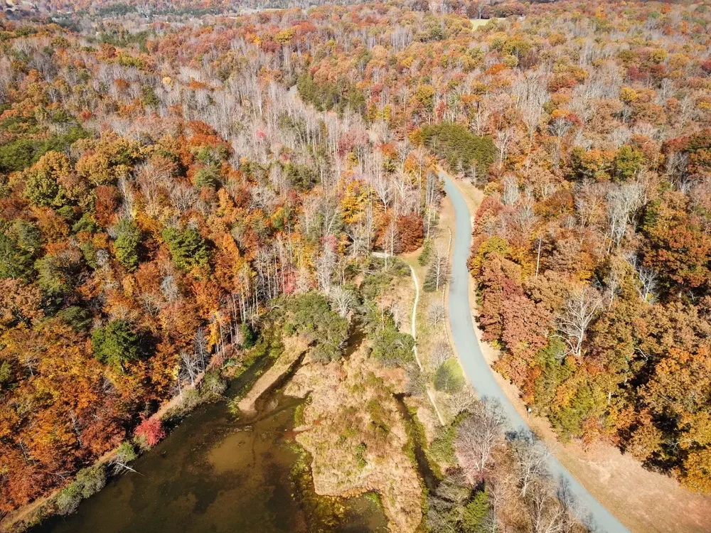
-
8
-
-
2 hours ago, Maestrobjwa said:
Was wondering if any higher elevations saw any flakes this morning
57 minutes ago, dailylurker said:I'm thinking the peaks over 3500' on Skyline Drive probably did or are seeing some.
Not even close to cold enough up top. Freezing line was up around 700mb at 8am this morning. 850s were in the low to mid 40s.
-
1
-
-
Flood Warning National Weather Service Baltimore MD/Washington DC 1227 PM EDT Sun Aug 21 2022 VAC003-540-212030- /O.NEW.KLWX.FA.W.0112.220821T1627Z-220821T2030Z/ /00000.0.ER.000000T0000Z.000000T0000Z.000000T0000Z.OO/ Albemarle VA-City of Charlottesville VA- 1227 PM EDT Sun Aug 21 2022 ...FLOOD WARNING IN EFFECT UNTIL 430 PM EDT THIS AFTERNOON... * WHAT...Flooding caused by excessive rainfall is expected. * WHERE...A portion of central Virginia, including the following county: Albemarle and City of Charlottesville. * WHEN...Until 430 PM EDT. * IMPACTS...Flooding of rivers, creeks, streams, and other low-lying and flood-prone locations is imminent or occurring. * ADDITIONAL DETAILS... - At 1227 PM EDT, Doppler radar indicated heavy rain due to thunderstorms. Flooding is ongoing or expected to begin shortly in the warned area. Between 1.5 and 2.5 inches of rain have fallen. - Additional rainfall amounts of 0.5 to 1 inch are possible in the warned area. - Some locations that will experience flooding include... Charlottesville... Newcomb Hall... Scott Stadium... Monticello... Barracks... - http://www.weather.gov/safety/flood -
It's so dark in Cville right now that street lights are coming on

72/69 with rain switching between moderate and heavy
-
1
-
-
Today has got to be one of the weirdest weather days for August I can remember. This little area of convergence has been stuck over the Staunton -> Charlottesville corridor for more than 12 hours now. Didn't make it above 70 until 11am, then only made it to 73 for a high. I think we'll be back into the 60s well before sunset. We've picked up about 0.5" since midnight.
-
2
-
-
1 minute ago, WinterWxLuvr said:
This is perfect. I’ll take 30 straight just like it please
I hope we get this weather straight through October every year
-
2
-
-
1 hour ago, MN Transplant said:
We haven’t had a lot of trailing stratoform regions this year.
What causes that to be so prevalent today?
-
65 dbz pixels on the cell West of Charlottesville
-
This morning's HRRR runs really missed on the convection in central VA right now.
Moderate rain and a few rumbles of thunder in Cville the past 30 mins.
82/76 at CHO. swampy.
-
23 minutes ago, WinterWxLuvr said:
Humidity levels go down with sunshine. Dewpoint no, but relative humidity does.
Right, with a 75 degree DP it needs to be about 95-100 to hit a "comfortable" humidity level and then the heat index is like 105+. I'll take 85, overcast and swampy every time.
-
23 minutes ago, WinterWxLuvr said:
Does anybody like sunny?
Not when the dewpoint is 75
-
1
-
-
This main cell over Cville has 45k foot echo tops with some of the loudest thunder I've heard in a while
-
3
-
-
25 minutes ago, Kmlwx said:
The HRRR has some smaller cells (nothing too impressive looking) for the metros. Thinking it *could* be distantly similar to the other day when things looked kind of lame and then cells kept training over MoCo. Maybe not to that degree but there could be training or backbuilding I'd think. Think that Flood Watch is more to cover the isolated cases of urban flooding or small creeks that inevitably occur in any storm that lasts more than 10 minutes.
I see the watch is through 5am. Seems like they're fairly confident in an evolution like the 3kNAM has of the Ohio MCS making it over the mountains and re-strengthening after midnight.


December Banter 2022
in Mid Atlantic
Posted
The problem is when a moderator says outside of subforum obs are fine to post when they're near her backyard, but any others aren't