Buffalo Bumble
-
Posts
1,613 -
Joined
-
Last visited
Content Type
Profiles
Blogs
Forums
American Weather
Media Demo
Store
Gallery
Posts posted by Buffalo Bumble
-
-
1 minute ago, Thinksnow18 said:
Still terrible conditions in Williamsville...starting to believe the open waters over the northern part of lake Erie is going to continue feeding this band all night.
Yeah, I just drove up to main st near intersection with Harlem and it’s brutal. My unofficial total is in the 22-24” range.
-
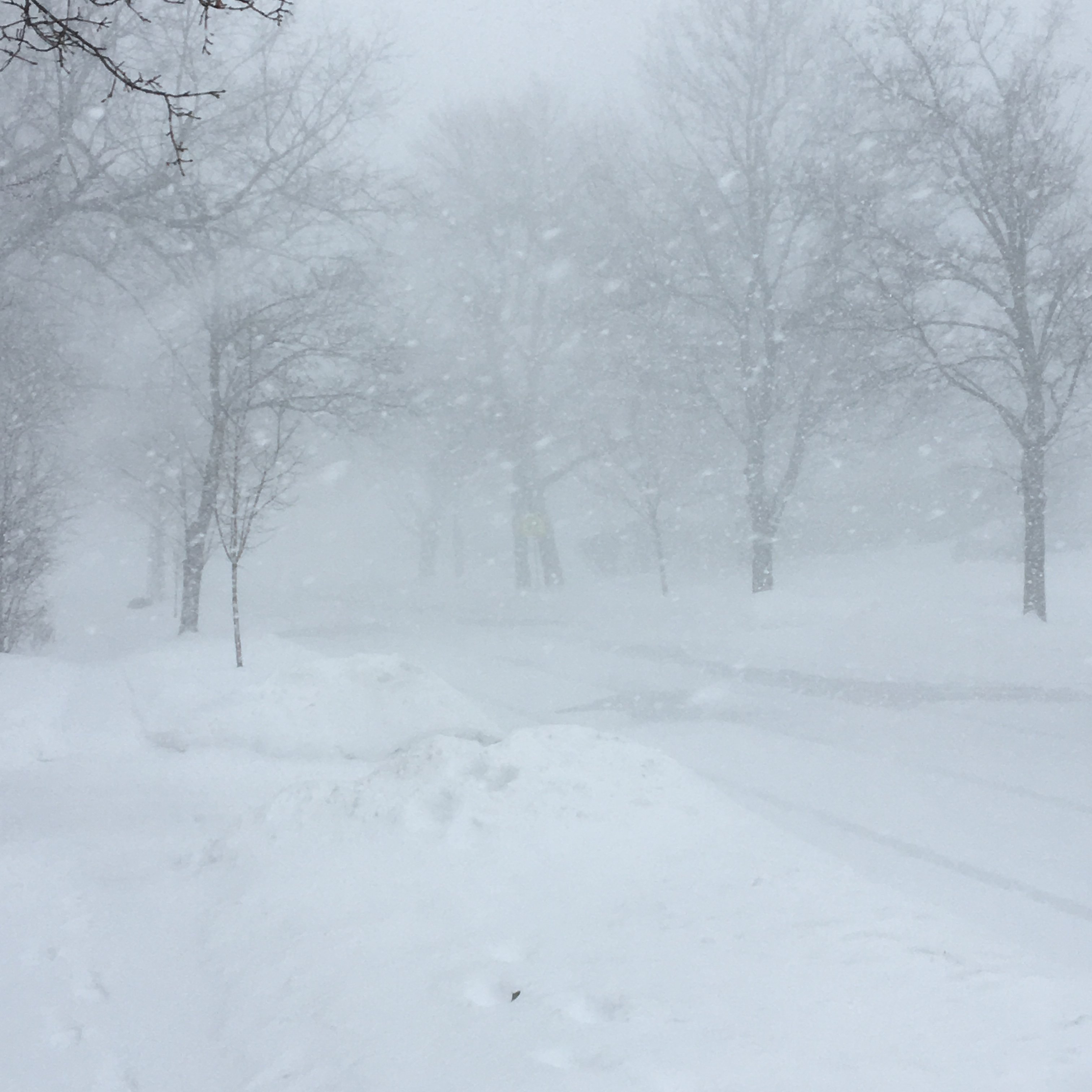
Blizzard conditions continue here with steady snow. Truly unreal.
Sky turned a deep shade of blue right at dusk with snow pouring down. Only thing missing was an Eskimo mushing a pack of huskies down the street.
-
 1
1
-
-
Looks like a double band firing off Ontario right now, one hitting Watertown area another hitting central Tug. Both look very strong, that extra lift on the Tug though should steal the show.
-
Spotter Reports National Weather Service Buffalo NY 326 PM EST Wed Jan 30 2019 ********************STORM TOTAL SNOWFALL******************** LOCATION STORM TOTAL TIME/DATE COMMENTS SNOWFALL OF /INCHES/ MEASUREMENT NEW YORK ...Erie County... 1 NW Williamsville 17.7 103 PM 1/30 Trained Spotter Buffalo Airport 16.1 300 PM 1/30 NWS Office East Aurora 14.0 200 PM 1/30 Trained Spotter 1 W Cheektowaga 13.0 126 PM 1/30 CoCoRaHS West Seneca 9.0 126 PM 1/30 CoCoRaHS S Buffalo 8.7 140 PM 1/30 Trained Spotter Cheektowaga 8.0 126 PM 1/30 Trained Spotter Lancaster 8.0 126 PM 1/30 CoCoRaHS 2 SSW Blasdell 7.0 215 PM 1/30 CoCoRaHS ...Genesee County... 4 S Corfu 14.0 200 PM 1/30 Trained Spotter ...Jefferson County... S Watertown 6.7 215 PM 1/30 CoCoRaHS ...Niagara County... 1 S Lockport 10.0 200 PM 1/30 Trained Spotter -
7 minutes ago, DeltaT13 said:
Probably not the time or place, but was fun to see what happens when a model really runs away with a system (unrealistically). The FV3 really cranked up this Nor'Easter. Basically a hurricane strength system. 943mb!!
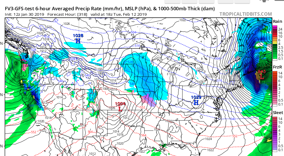
Someone's bored, posting a 300+ hour op run...Crazy depiction for sure though!
-
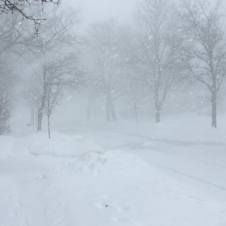
Blizzard conditions 100% verified!!! Just had a pretty crazy experience...Left for the the Galleria mall at 1 PM after heard they were closing at 2 PM (long story why I would drive down there in this weather, but it involves a daughter studying abroad and needing Euro's ASAP...). Conditions weren't too bad at home, snowing pretty good but we're sheltered from the wind. The 90 from 290 down to Walden was passable, times of reduced visibility down to 100 feet but manageable. But Walden Ave itself not so much. Basically 0 visibility, cars crawling and trying not to run into each other. Somehow managed to turn onto the mall road, which was a mistake. No visibility whatsoever, and no idea where to turn into main parking areas. Hoped for the best that no vehicles were coming and managed to turn around. Then it took 10 minutes to find an exit back onto Walden. Navigated around a jackknifed tractor trailer and another car off the road to get back on the 90, then mostly smooth sailing home.
As much as we love this weather, it's actually quite scary to be in the middle of a full-fledged blizzard. Not a great feeling to be surrounded by nothing but white with no idea which direction to turn. That said....truly EPIC conditions in the BUF!!!!
-
1
-
-
Heavy snow here yet again as that northern band punches inland.
-
Winding down here, looks fantastic right now in the southtowns. Enjoy it down there today! Just finished digging out from at least 20" here, over 12" new since my last dig out last night around 11pm.
-
10" new here between about midnight and 7AM, putting me over 20" for the event. Snow+ continues, flake size still solid, and absolutely no wind.
-
2
-
-
S+ continues here, over 12” for the event now.
-
3
-
-
"Good evening ladies and gentlemen, we'll have you on the ground in Buffalo in about 15 minutes. Current temp is a nippy 12 degrees, with gusty winds and heavy snow. Ground control reports the runway was cleared of snow about 30 minutes ago, so there should only be about 2 inches of accumulation when we touch down. Enjoy your stay."

Heavy Snow Blowing Snow
12°F
-11°C
Humidity 87% Wind Speed W 13 mph Barometer 29.85 in (1012.2 mb) Dewpoint 9°F (-13°C) Visibility 0.25 mi Wind Chill -3°F (-19°C) Last update 29 Jan 9:54 pm EST -
1
-
 1
1
-
-
Over 10" now. Still heavy snow here, but flake size is taking a little hit as temp continues to drop.
-
1
-
-
Erie band has that whipping fire hose look to it that BUF mentioned. Not ready yet to lock in to a steady state. As such, continue to flip between heavy and light/no snow here.
-
Squall line just moved in here too. Same as Nash, can barely see houses across the street.
-
17 minutes ago, WxWatcher007 said:
Really picturesque scene here as the snow growth is better and dendrites flutter to the ground.
Mod snow reported at the airport with visibility around a quarter mile.
https://www.wrh.noaa.gov/mesowest/timeseries.php?wfo=wrh&sid=Kart&num=64#
(5 minute obs)Yeah, radar looks great up there right now. Looks like some solid enhancement to the synoptic moisture.
-
Back to snow++ here last 30 minutes, added another inch during that time. Wind still not that strong so monster flakes are mostly coming straight down. It's also surprisingly not that cold out right now.
-
Snow starting to pick back up again here after a lull for a couple hours. Just under 6" on the day so far.
-
2
-
-
Always fascinates me how the wind drops off so much in the heart of a strong lake effect band. I'm close to the center of it now and it's nearly calm.
-
Piling up incredibly fast here with giant parachutes coming down.
-
5 minutes ago, AppsRunner said:
Meant to type something up last night… but I guess this will have to do. I’ve been away from the LES action for a little bit so take it with a grain of salt.
Awesome write up, thanks for taking the time to do this! Stay warm in the ice box...
-
11 minutes ago, WesterlyWx said:
Wow that band is absolutely cranking and consolidating right over the northtowns. From the north side of the city to Tonawanda and N. Amherst are getting raked!!
Heavy snow here, very impressive flake size too so it's piling up nicely. Closing in on our 4" forecast total for the day already...
-
Wind is starting to pick up here now. Vis dropping down to couple hundred feet in gusts and heavy squalls. Pushing 2" since 8 AM. Accurate measuring is gonna be tough.
-
Pulsating here between heavy and lighter snow. Actually pretty cool when the sun peeks out with giant dendrites pouring down. Here's a shot during a heavy cell a few minutes ago.
-
5
-
-
Checked the radar thinking this might just be a passing squall line, but sure looks like it's coming up the length of the lake. Looks like BUF wasn't expecting much to get going until late morning, and only up to 4 inches during the day:
Additional snowfall
will also occur northeast of Lake Erie as lake effect snow begins to
develop late this morning as cold air advection begins after the
cold front moves through. Northeast of Lake Erie can expect up to
around 4 inches of snow through the early evening, primarily from
lake effect, but also includes some earlier snowfall with the
frontal passage. Light to moderate accumulating snowfall is likely
to be ongoing for the Buffalo Metro area during the evening commute.
Upstate/Eastern New York
in Upstate New York/Pennsylvania
Posted
Yes, it is. Heaviest snow of the day here now.