Buffalo Bumble
-
Posts
1,613 -
Joined
-
Last visited
Content Type
Profiles
Blogs
Forums
American Weather
Media Demo
Store
Gallery
Everything posted by Buffalo Bumble
-
Upstate/Eastern New York
Buffalo Bumble replied to BuffaloWeather's topic in Upstate New York/Pennsylvania
Nice! I’ve never hiked the ADK high peaks this time of year. Must be cool going from spring/green to winter over the course of a few hours. Which peaks are you planning to bag? -
Upstate/Eastern New York
Buffalo Bumble replied to BuffaloWeather's topic in Upstate New York/Pennsylvania
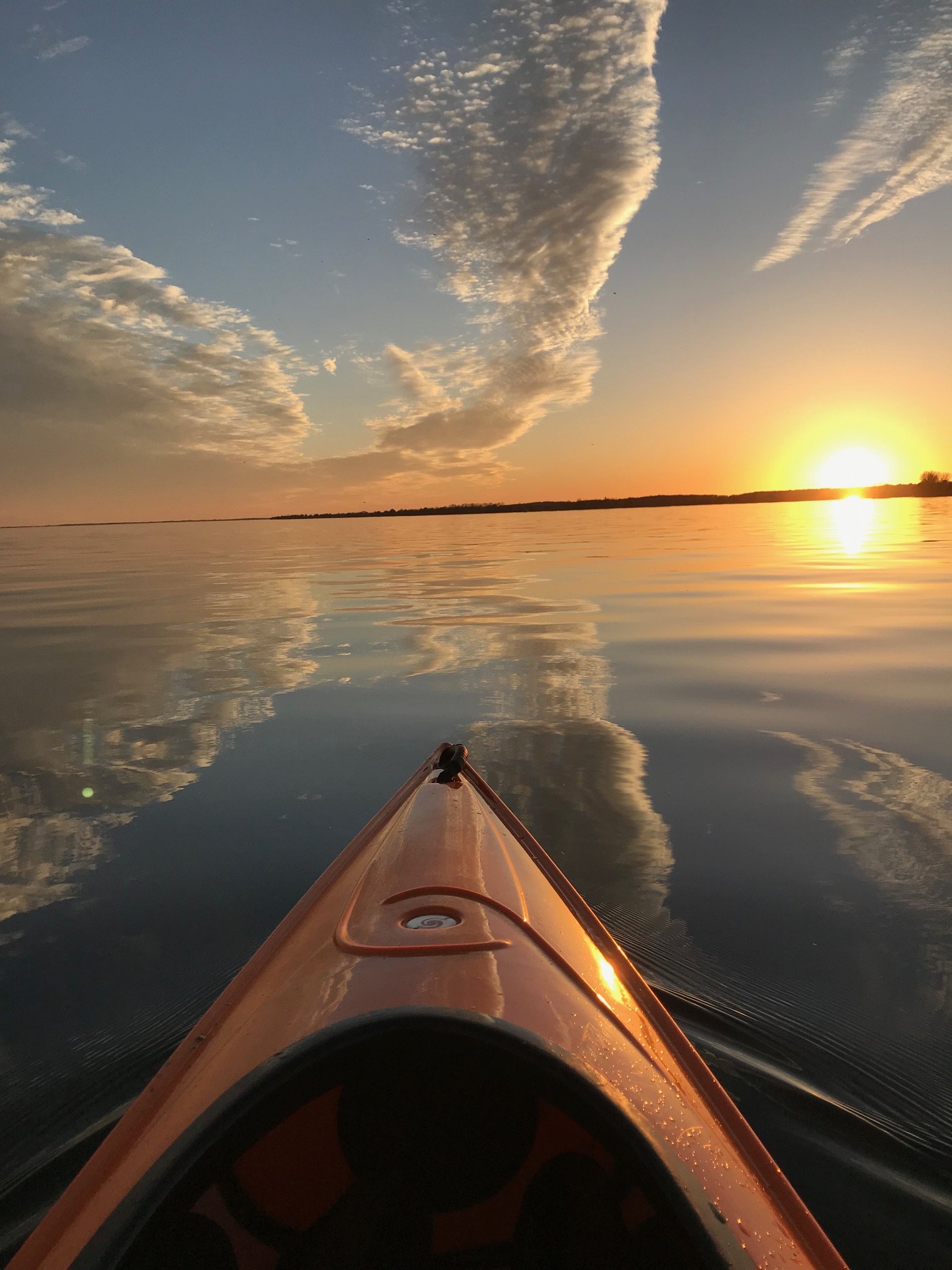
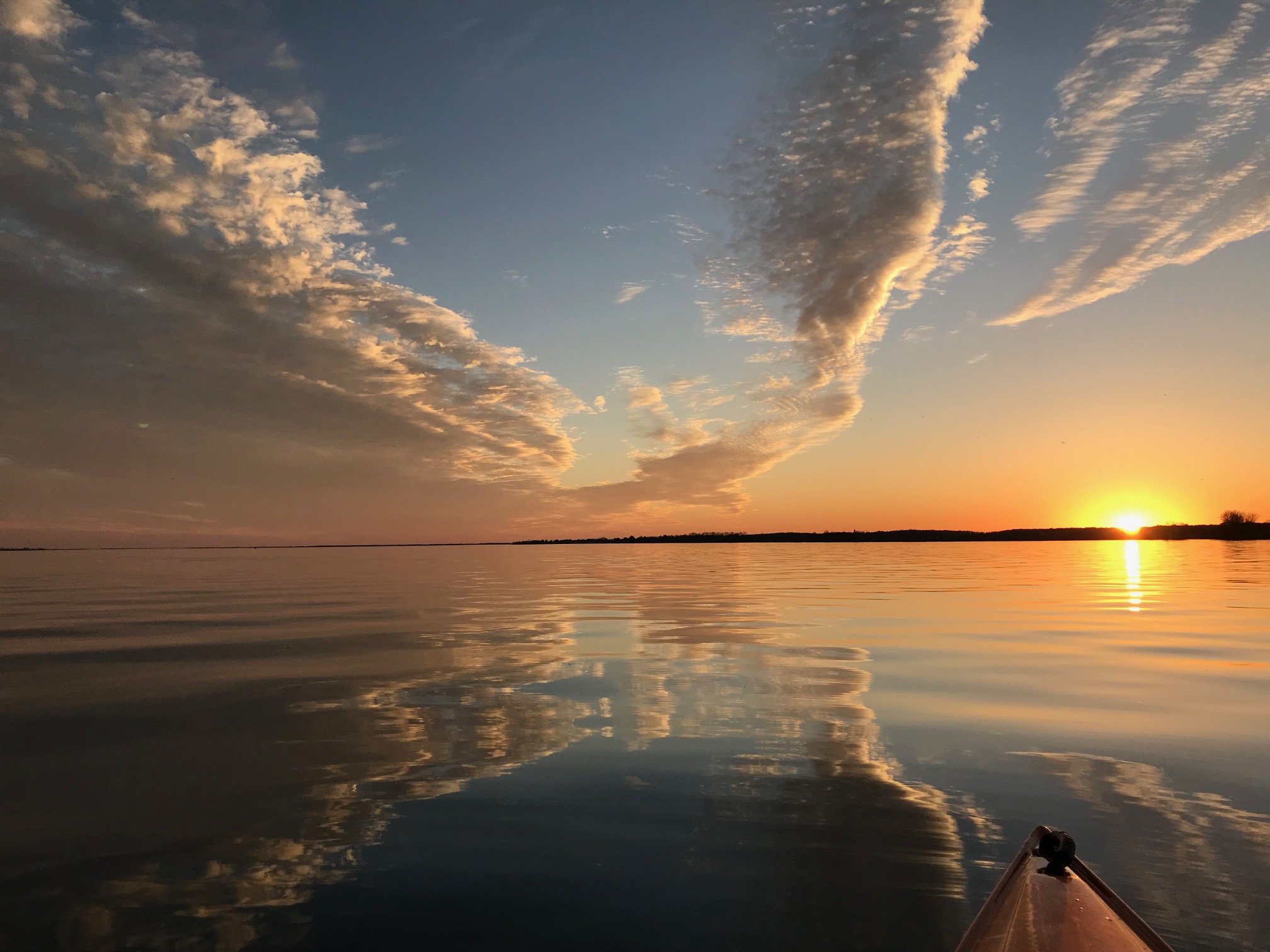
Stayed north of the clouds up at Chaumont Bay today. Made for a nice sunset tonight with clouds encroaching from the south. These shots are facing west across the bay.

-
Upstate/Eastern New York
Buffalo Bumble replied to BuffaloWeather's topic in Upstate New York/Pennsylvania
You posted a good follow up analysis to your first “trollish” June will be cold post, and this is informative too. Sorry, we’re a bit sensitive here after being traumatized by weeks of horrible weather. All good. -
Upstate/Eastern New York
Buffalo Bumble replied to BuffaloWeather's topic in Upstate New York/Pennsylvania
After enduring a horrifying 6 weeks of weather and now in the middle of awesomeness, you jump in to troll about a cool/wet June? Weak... -
Upstate/Eastern New York
Buffalo Bumble replied to BuffaloWeather's topic in Upstate New York/Pennsylvania
Also...does anyone else feel like summer just busted through the door? Skies cleared here a couple hours ago and the air feels great. I’m sure we’ll have to contend with more chill here and there, but forecast looks solid into next week. -
Upstate/Eastern New York
Buffalo Bumble replied to BuffaloWeather's topic in Upstate New York/Pennsylvania
Yeah, we dodged a big bullet. With a cottage on Lake Ontario already under attack by the high lake level, I was dreading a mega rain event. Hopefully all the rain over IL and MI doesn’t impact the system too much. -
Upstate/Eastern New York
Buffalo Bumble replied to BuffaloWeather's topic in Upstate New York/Pennsylvania
Stacked low pressure across the upper Mississippi Valley on Sunday will very slowly slide southeast across Ohio on Monday. This will push a warm front across our area that will then stall out and become the focal point for what might be several rounds of rain (possibly moderate to heavy at times) through at least Monday, and potentially beyond. Upper low becomes completely cutoff by Tuesday as it settles across the east-central U.S., and looks now as if it may linger right through the upcoming week. This will keep at least the threat of showers going through mid week if this trend continues. On a less important note, this may also put the kibosh on the above average temperatures that looked possible just a few days ago. Now, to the more important potential for heavy rain. The best shot appears to be later Sunday through Monday night at this time, possibly longer as tropical moisture gets pulled in from the Atlantic as the subtropical low tracks northward. This is favorable for a predecessor rain event (PRE). A PRE consists of meso and/or subsynoptic scale regions of heavy rainfall that occur well in advance of recurving tropical cyclones over the eastern third of the U.S. All this said, the big question is where exactly this axis of heavy rain sets up. This remains uncertain at this time being still a good distance down the road, however as mentioned above, the possibility continues to look more favorable with the past few model runs. Some of the things to consider are: Does the tropical/subtropical system curve out into the Atlantic earlier allowing the cold core system to track further east, then the heaviest rain could end up being outside our region, and/or to a lesser extent. This would likely speed up the progression of the cold core low, which would limit residence time as well. However, models have continued to trend with a further west track of this system, so this will be something to continue to watch in the coming days. Confidence is increasing for the potential of a few, to possibly several inches of rainfall with this set up, which would likely produce flooding if this scenario came to fruition. Will place a mention in the HWO at this time. The upper level energy that will eventually mature into this potentially impactful system still resides off the west coast of British Columbia, so there is obviously plenty of time for things to change. Nonetheless, as stated this will need to be monitored closely going forward. Stay tuned. -
Upstate/Eastern New York
Buffalo Bumble replied to BuffaloWeather's topic in Upstate New York/Pennsylvania
For the stats nerds...BUF is -9.8 deg for May as of yesterday. All but one day this month has been below average. Current streak of at least -7 extends back to May 4th. It would probably take the torch of all torches at this point to finish the month at or above normal. Looked promising on the modeling yesterday, today not so much. Some of the other northeast threads are complaining about sitting at -4 or -5 departures for the month. They've got nothing on us... -
Upstate/Eastern New York
Buffalo Bumble replied to BuffaloWeather's topic in Upstate New York/Pennsylvania
Models were great when they predicted unrelenting cold from April through yesterday...Not looking so good for the big warm-up though. That said, going from a typical range of 20's-40's for 6 weeks to 40's-60's is certainly a big improvement. -
Upstate/Eastern New York
Buffalo Bumble replied to BuffaloWeather's topic in Upstate New York/Pennsylvania
The extended forecast looks great, but...I just can't help myself. Today is about the biggest abomination of a close to mid-May day of weather you can ask for (oh, maybe except for Saturday). 40 degrees and near constant light rain. And the brightness level of November. At least in November it gets dark by 5 pm so you can transition from dark gray to black. But lucky us, now we get 14 hours and 32 minutes of dim light against a dense gray canopy. Ok, rant over, time to stoke up the fire... -
Upstate/Eastern New York
Buffalo Bumble replied to BuffaloWeather's topic in Upstate New York/Pennsylvania
Yes please! -
Upstate/Eastern New York
Buffalo Bumble replied to BuffaloWeather's topic in Upstate New York/Pennsylvania
Yeah, I probably got carried away by the thunder snow. I would be curious though to see how this stacks up against the other May snow/cold events in terms of duration and timing. Accumulating snow 2 straight days during peak heating seems tough to beat. -
Upstate/Eastern New York
Buffalo Bumble replied to BuffaloWeather's topic in Upstate New York/Pennsylvania
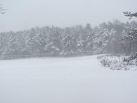
I’ve gone from being annoyed by this weather to absolutely fascinated. Is it possible in the modern climate regime (eg last +\- 400 years) to experience anything more anomalous than this? 2pm on May 9th and I just had a blinding snow squall whip through with near 0 visibility, temp of 30 degrees, and a fresh new inch on the ground. -
Upstate/Eastern New York
Buffalo Bumble replied to BuffaloWeather's topic in Upstate New York/Pennsylvania
Reports of whiteout with thunder and lightning along Niagara River in Tonawanda (from my wife who for some reason thought it would be a good idea to take a walk along the river this afternoon). She called me half crying/half laughing because it was so crazy and intense. -
Upstate/Eastern New York
Buffalo Bumble replied to BuffaloWeather's topic in Upstate New York/Pennsylvania
Amazing pics from you guys in eastern NY. Another day of frequent snow squalls here. That's probably what amazes me most about this...I remember other snowfalls in May, it's not that uncommon. But the sun comes out, snow melts quickly, and we jump back to spring. This is legitimately locked in winter for 2+ days. No quick melt, no warming breeze. Just...winter. -
Upstate/Eastern New York
Buffalo Bumble replied to BuffaloWeather's topic in Upstate New York/Pennsylvania
Great shot!! Clear here too, if wind drops temps should really nosedive. -
Upstate/Eastern New York
Buffalo Bumble replied to BuffaloWeather's topic in Upstate New York/Pennsylvania
I'm certainly no climate scientist and haven't read too much on this, but...I bet you would find that average temps here from about mid-March through May are much cooler than the rest of the NH at similar latitude for what seems like 2 obvious reasons - 1) frozen Hudson Bay and residual snow cover in eastern Canada extending down to 45 deg latitude; and 2) massive bodies of water (Great Lakes) immediately upstream ranging in temps from freezing to 50 degrees. Combine that with building heat domes in the southwest US pushing up into the Rockies with a propensity for air coming off the Rockies to bend southeast, and you have a perfect recipe for a mean trough over the upper GL's/northeast US. Seems like from Washington D.C. points west are immune from our seasonal spring lag/extended winter as they mild and green up on que in early April. -
Upstate/Eastern New York
Buffalo Bumble replied to BuffaloWeather's topic in Upstate New York/Pennsylvania
I feel like this current NH snow cover image is a good indication of why our springs more often than not are horrible (cold, wet, cloudy, snowy). Snow cover persists towards the 45th parallel right over our heads, whereas the rest of the NH is snow free up to the 60th parallel. Perfect recipe for our spring "perma-troughs", and certainly a clear pathway for polar air to slide into our region with accompanying fat fluffy snowflakes. And during the middle of the day 6 weeks from the freaking summer solstice no less.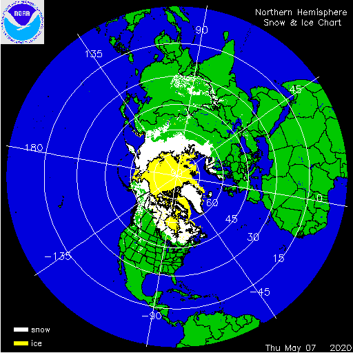
-
Upstate/Eastern New York
Buffalo Bumble replied to BuffaloWeather's topic in Upstate New York/Pennsylvania
I made a post in mid-April about being rather amazed to see "real" snow falling in the middle of the day (big flakes, sticking easily...like look out the window and it could be January). Fast forward to May 8 at 1115 am and same exact thing! Gentle mid-winter snow parachuting down. Unreal.