


showmethesnow
-
Posts
7,250 -
Joined
-
Last visited
Content Type
Profiles
Blogs
Forums
American Weather
Media Demo
Store
Gallery
Everything posted by showmethesnow
-
Haven't looked hard into it, would rather play my slots , bbut I like the improvements we have seen at 500s compared to the 12z at the end of the extended. Eta: as far as the pac, PV positioning around Green land degraded some what though.
-
Know this is banter but what the hey. Merry Christmas to you as well. I am at the rocky gap casino in western md and it is freaking great. Slots have been paying out great. Casino is clean, hotel is very nice and the food is good. Already decided I will make this my destination if we can get a good weekend snowstorm this winter.
-
Not hating the look the gefs is now throwing at us in the extended. Definitely a workable pattern as long as we stay on the right side of the boundary that will set up with that ridging in the se.
-
Despite the 00z gefs clocking in with probably a neutral epo that is a cold look in the extended. Neg temp anomalies it is currently depicting are probably even understated.
-
Heading out for the week to hit up family and a couple of Casinos so I won't be following as much as i normally would. But when we get back Sunday I have a very strong suspicion that what we currently see projected for the 10-15/16 day period will bear little resemblance to what we actually see next Sunday. Especially in regards to the PAC. Currently we are seeing a flat PAC flow into the West and I just don't buy it. Think we are going to see amplification with the long wave pattern through that region and it will just be a matter of where the troughing and ridging sets up and that will be determined by what pv presence we see around Alaska and its placement. By Sunday I strongly believe we will be looking at either a very sweet look for the PAC if we see the pv feature in that region rotate out around the Aleutians. Or conversely we could be looking at an absolute dumpster fire if that feature sets up shop on top of Alaska and we see a subsequent western trough extend down into the perpetual weakness we have seen in the SW these last few years. I see arguments for either case so which plays out is a coin flip in my mind. As far as the NAO? Who the hell knows. That will pretty much depend on where we see the major pv set up shop when it shifts eastward. Right now both models place it in one of the worst spots possible. They could be right but then again they are just as likely to be wrong and it wouldn't take much of shift to drastically improve the look.. So I guess what I am saying is, take what we are currently seeing on the models with a grain of salt because more then likely this is not what we see in a weeks time and the differences between a sweet look and a crap look are just a matter of some minor adjustments/placements of a couple of features.
-
Never said it would. Just trying to find something positive to say about some crappy overnight runs.
-
Just glanced at the latest EPS. Pretty rough looking in the higher latitudes but we did see some slight improvements here and there from the 12z. That said the look in the extended is workable given the time of the year but I wouldn't hold my breath waiting for snow.
-
Waiting on the EPS to finish running to see what it has to say, but yeah the GEFS was pretty rough looking. Starting to hit hard on having a pv influence in/around Alaska and the latest run is following the EPS idea from yesterdays 00z run of planting that squarely into Alaska where we do not want to see it. Good thing here is that it doesn't take much of a shift with that feature (westward) to get a good look. As far as the NAO it won't win many friends. PV planted squarely in the western NAO domain and its influence spreading across Greenland down into N Europe. The run was pretty much the 2 worst case scenarios from my post yesterday. Won't say recent trends aren't somewhat concerning but I will reserve judgement for a few more days. Wouldn't take much to turn this look into a pretty good look and it probably all keys on how it handles the main piece of pv as it rotates eastward towards Greenland. See a farther southward drop and I think we see a good response in both the PAC and the NAO domains. As it is the current look being thrown up isn't what i would call a high probability look for our snow chances, far from it actually, but it is one that can be workable considering the time of the year.
-
Where the pv is currently depicted in the extended on both models it will be hard to maintain any sort of -epo/-nao regime for long, if at all. How it is evolving on the models at this time our hope is probably that both models are under playing the southward drop of that feature. See the models start placing that closer to Hudson Bay and I think chances are pretty good we see the upper latitude blocking showing up in both domains with even an outside shot of seeing a possible attempt at bridging between them.
-
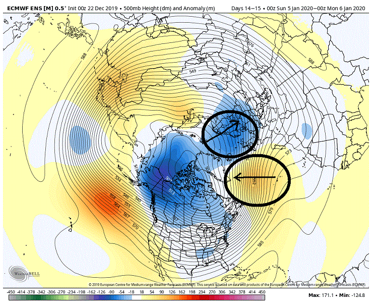
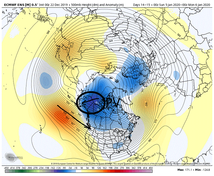
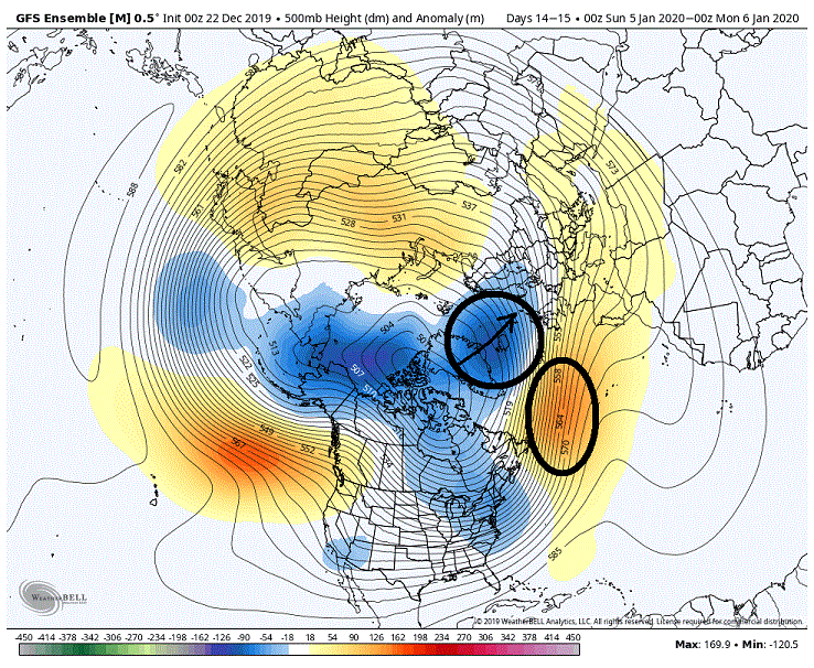
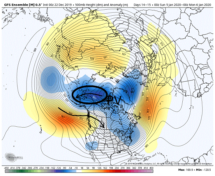
The possible favorable changes to the pattern concerning the PAC are initiated Day 8-10 (Roughly day 8 GEFS, Day 10 EPS) as we start to see the PV make its move eastward towards Greenland. The models have shown for awhile that the pv's influence in the N PAC around Alaska would be substantially reduced as we would see everything mostly shifted eastward. But what I have suspected for while now (because of the ambiguous looks the models have been throwing out in this region) is that we would still see a fairly significant pv presence in this area even after we saw the shift of the main PV eastward. That said I believe the models may now be starting to pick up on this. If we look at the EPS below note that we are now starting to see strong negative anomalies and weak troughing extending westward through Alaska. This implies to me that the EPS is now possibly moving towards at lest pv associated troughing through that region, if not a piece of pv actually residing in that region. Now the current look is still workable despite the flat flow we are seeing coming off the PAC given the time of year. The problem here is that is probably not the look we get if we do in fact see troughing/piece of pv located close to or through Alaska. Chances are good that we would actually see is a repeat of the troughing extending down the west coast as we are now currently seeing and will see over the coming days. Needless to say this is the last thing we want to see for our snow chances Now the GEFS is also picking up on the idea of a stronger pv presence/influence around Alaska as well. But note we are seeing a difference where the stronger anomalies and troughing are compared to the EPS. These features are running north of Alaska and hooking down into the Aleutians. This is a much more favorable location for this feature and one I want to see. As a result of this we are now seeing the ability for height builds/ridging to extend up the west coast into Alaska. This would go a long way in improving our snow chances. Pretty amazing when you think about it, what just the small shifting of one feature could mean in regards to our snow chances. Now the PAC is just one part of the equation when it comes to our snow chances. Let's see what is occurring in the N Atlantic as the pv shifts. Interestingly enough, the EPS has a better solution then the GEFS. Note that the stronger neg height anomalies/troughing are situated mostly north of Greenland. This positioning is allowing the ability for stronger height builds northward into Greenland. Considering that we typically see smoothing at this range on the ensembles we would probably see a greater amplification of the troughing and ridging as it neared in time considering what is being presented at this time. Which would be a good look for us as it would place blocking in the central and western portions of the NAO domain. But if we look at the GEFS the neg anomalies and troughing run directly through Greenland (strong +NAO). This is effectively squashing the flow and not allowing the greater heights to build northward as we see on the EPS. And given the look I don't think we could count on seeing an improvement with the heights/ridging even if we consider smoothing. Again we are seeing just a minor shift of a feature that can have a fairly significant impact. Now if we could see a combination of what the GEFS is suggesting in the PAC as well what the EPS is suggesting in the N Atlantic I believe we would end up with a very good look through the CONUS as far as our snow chances. But we are still 8-10 days away from when all this get jump started by the pv's eastward migration so much can/will still change.
-
BWI: 11/16 DCA: 11/26 IAD: 11/16 RIC: 11/26 Tiebreaker: 8”
-

Best Mid-Atlantic winter storm of the last 50 years
showmethesnow replied to AnEndlessMaze's topic in Mid Atlantic
Has to be my favorite as well. Most on here are too young/not born yet to understand what they missed. Insane rates, wind, thunder snow. Had drifts that I haven't seen equaled since. Was a surprise storm as well where they were only calling for flurries the night before. Woke up to maybe 6 inches on the ground with white out conditions. Was a few days before my 15th B-Day and was by far the biggest snow I had ever experienced up to that point (the 70's were total crap). Added bonus was that it was on a Monday and they called schools for the whole week. -
What's this I hear about a drought? Meh. Get back to me when the pendulum swings and we get flooding rains. Would like the heads up so I can go out buy lumber for my Ark before they sell out.

