showmethesnow
-
Posts
7,250 -
Joined
-
Last visited
Content Type
Profiles
Blogs
Forums
American Weather
Media Demo
Store
Gallery
Everything posted by showmethesnow
-

Central PA - Winter 2020/2021
showmethesnow replied to MAG5035's topic in Upstate New York/Pennsylvania
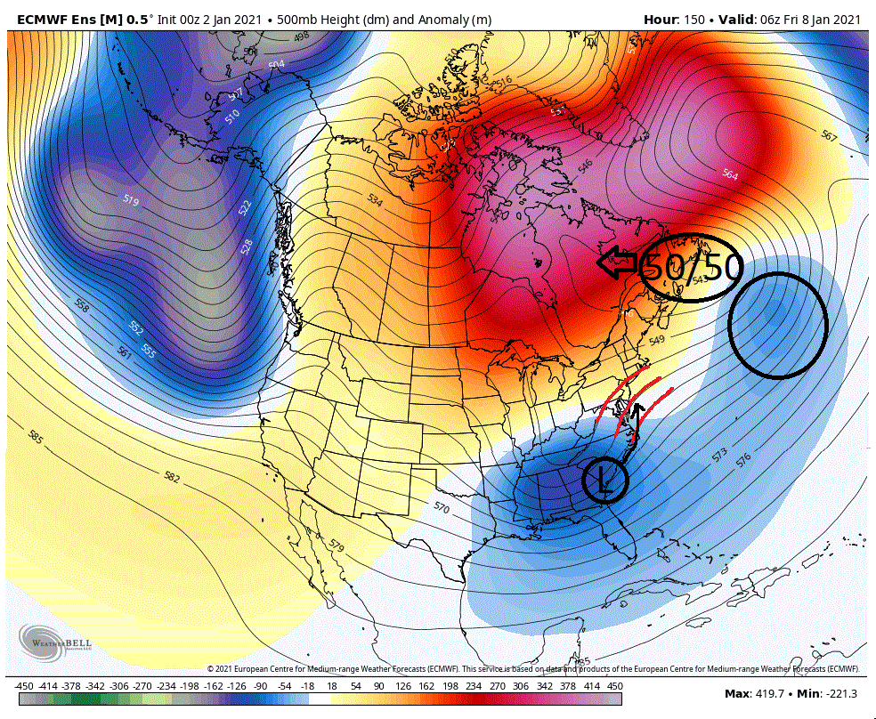
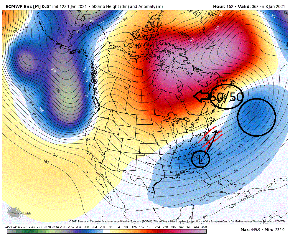
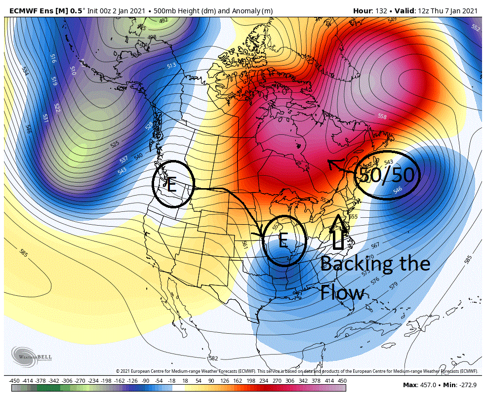
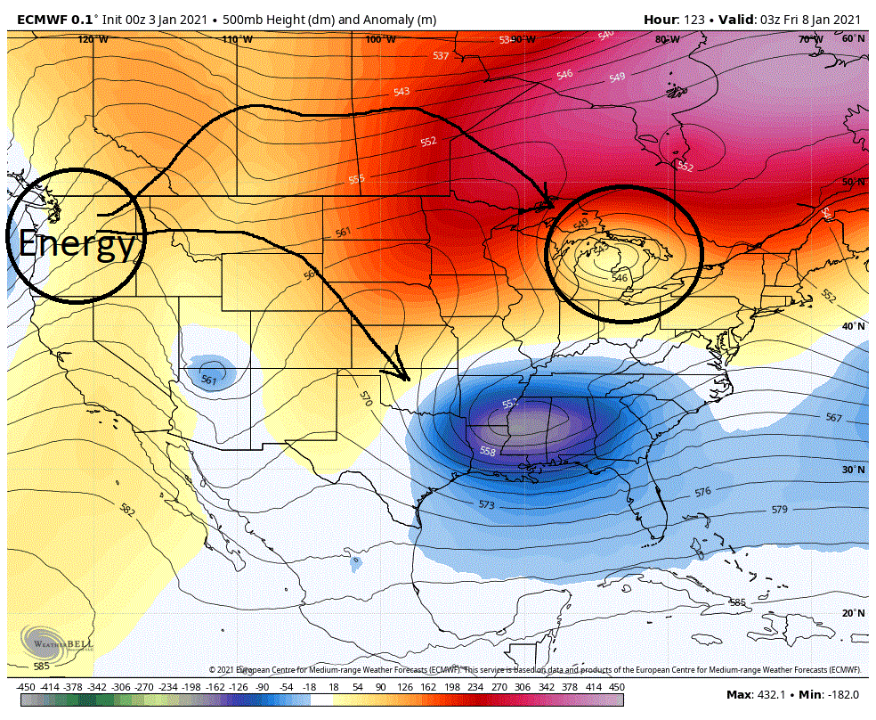
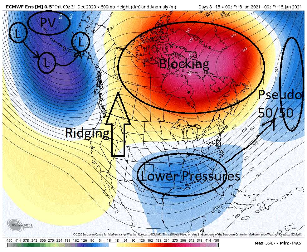
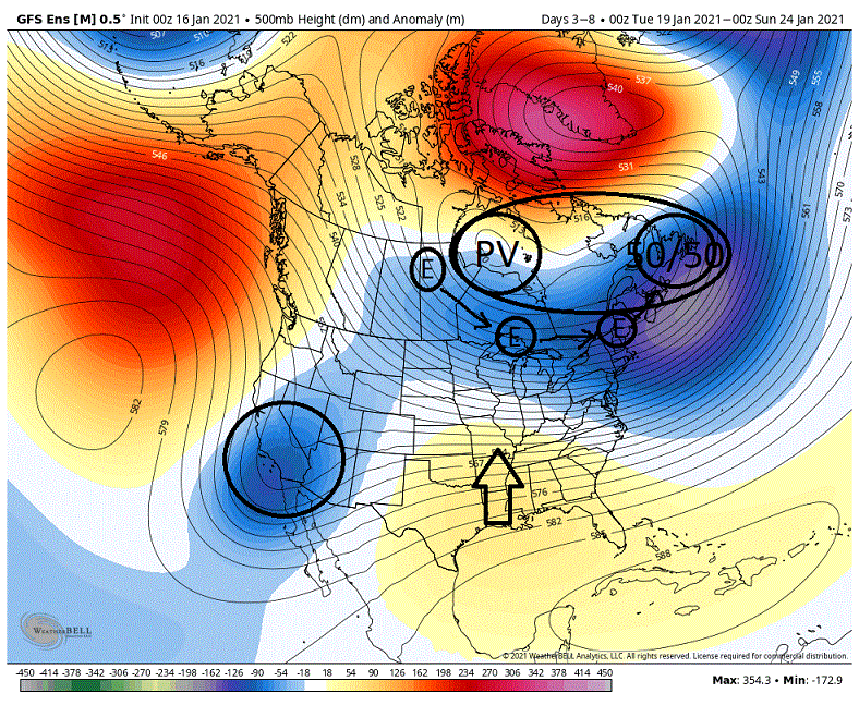
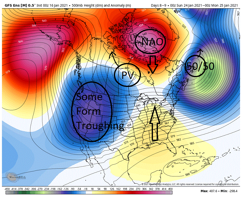
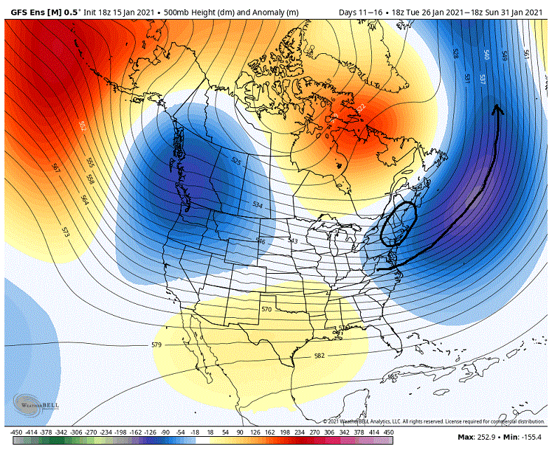
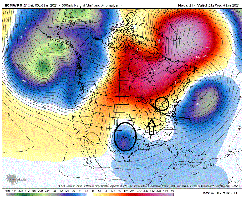
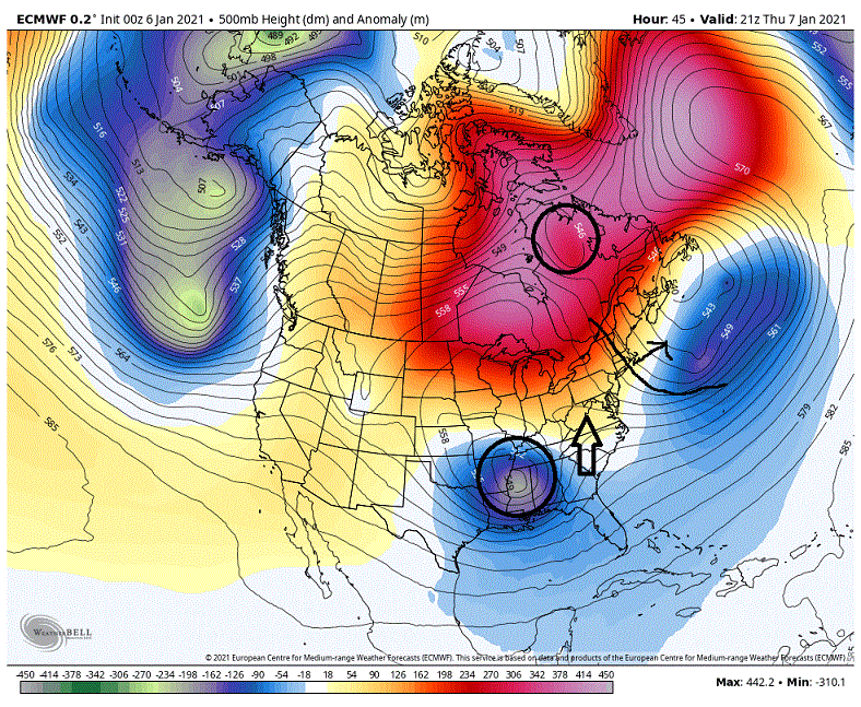
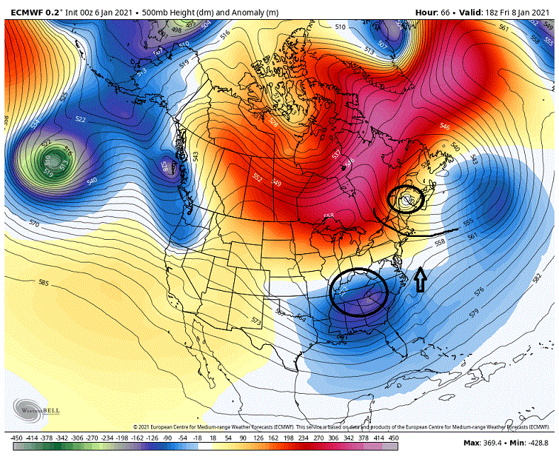
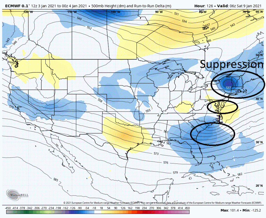
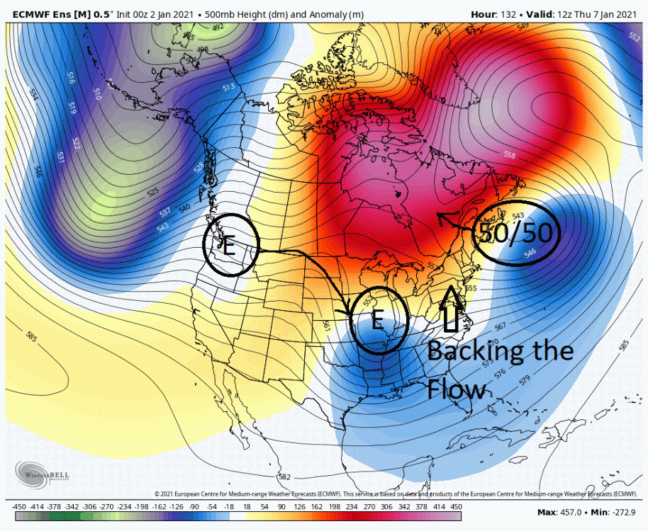
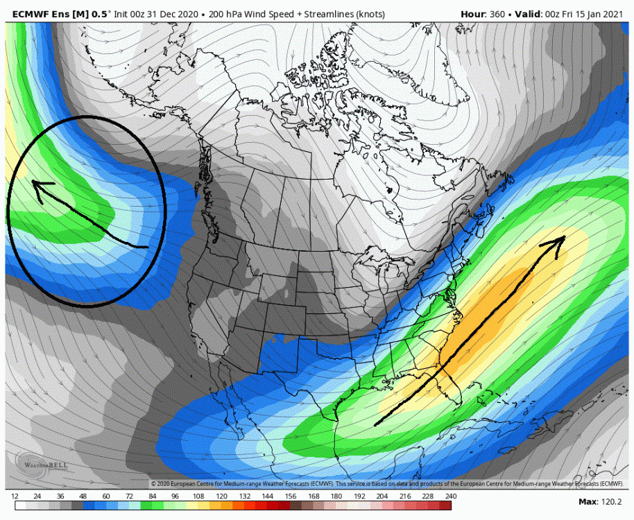
The models (EPS, GEFS, CMC) are hitting pretty hard on the fact that the next 8/9 days will be for the most part uninteresting in the snow department in the east. Basically we have a shredding machine setting up to squash and rip apart any energy that moves into the east. But take heart, after this period things actual start looking more upbeat on the models. Below we have the 5 day mean on the GEFS day 3-8 (All models agree on this general setup). What we have setting up is a PV and 50/50 couplet overtop central and eastern Canada. Around this feature we have energy rotating around the PV towards the 50/50 helping to reinforce it. Note the fairly impressive low pressure anomalies for a 5 day mean through the Lakes and through the NE. This is pretty formidable suppression which would take a lot to combat. What is attempting to push back against it is the cutoff low/lower latitude troughing in the SW and the responding forcings it is creating in the lower latitudes for ridging in the southern states. This really is not a good setup for a general snowstorm in the east and as we have generally seen on the models, everything moving eastward in the mid-latitudes fizzles out. Doesn't mean some won't see snow. Those who typically enjoy lake enhanced snow as well as those up in New England can do quite well as the PV energy rotates around and then amplifies as it hits the coast off of the NE and Canada coast. Now I wouldn't call this a shutout pattern through this period for a general snowstorm outside of the areas mentioned above. But it isn't pretty. The models have been having a rough time in the Southwest with the energy so maybe we see something actually there that has more oomph. Or we could possibly see a short lapse in the suppression which a system could take advantage of. But even in these cases I think we would be hard pressed to get anything meaningful above 40N in the East, west of the Apps. Now to give you a better idea of what systems are encountering as they move eastward look at the closeup map below. I think the anomalies tell the story here. Not only that but look at the angle of these anomalies. The isobars tell the story as we are seeing a significant downhill look into the east for a 5 day mean. This is an impressive, suppressive look. But I did say take heart (or at least as much as you can for 10+ day projections). As many are aware and have been talking about, the models have started hitting on a potential storm roughly around the 26th. If the models are somewhat correct with some of the major features and how they handle them then this is actually a legit window IMO and not just another fantasy threat we see at 10+ days all to often. Below we have shortly before this period of interest. What is occurring is the PV and 50/50 couplet is now in the process of separating. The PV lobe is rotating up towards the pole and the 50/50 is migrating eastward (Good timing of the 50/50 low moving eastward and relaxing its influences for a possible storm). Between these two features we now how the higher heights over the NAO domain nosing southward between them. This is effectively cutting off the NS energy rotating around these features and along with it the suppression through the Lakes and into the NE. With this relax in suppression the ridging in the south is taking advantage of it. Ridging that is created by the general troughing in the west. That general troughing/energy in the west the models have been having a hard time handling recently. So what actually verifies could have somewhat significant influences on the evolution of any system in the East. But for now we really have to leave this and any possible influences as a question mark. Now I mentioned I felt that this may be a legit threat and not just another phantasy one. Let me explain why. Generally, many of our 10 day threats revolve around smaller scale features (more MESO scale in nature) and some intricate timing between them to force the pattern for a storm signal. Expecting the globals to get all that right at such ranges is asking a hell of a lot. So typically we see a storm show up for a few runs or even a day or two and then it disappears as the models then start picking up on different timing of these smaller scale features. But this is not what we are seeing here. What is forcing the pattern in the East and hence the storm signal, are the major players (larger scale features). It is all revolving around the NAO/PV/50/50 and how they evolve and the globals have a better handle on these features at longer ranges. What is comforting as well, is seeing all three models in unison with this evolution. And despite what some may think, the models have done a pretty good job in the longer ranges with how they have handled the Greenland/Eastern Canada/N Atlantic domain where these features are located. So short of the SSW/split impacting this negatively as it works its way down through the atmosphere I believe chances are good we see a semblance of this look verify despite being 9/10 days out. ***Word of caution, there is always a possibility we could see something cut to the west to a certain point before moving/transferring east. What form of troughing and strength we see in the West could play a big part in that.*** Thought I would also make a quick mention on what we would see any post day 9/10 storm. Even there we are now seeing some positives through the day 11-16 period. Though you may #$%#@ when you look at the isobars and see the same steep downhill look in the east that we saw in the above example they really are not the same. The difference here is the lower pressure anomalies extending from the 50/50 have now shifted south from targeting NE and are now targeting the mid-Atlantic. What this is implying is that we are more then likely seeing systems moving through the mid-Latitudes and amplifying as they move off the coast (the prior example we were seeing NS energy running the border and amplifying as it hit the coast). In this look below, generally the NW sector of the low pressure anomalies (circled) is where you want to be.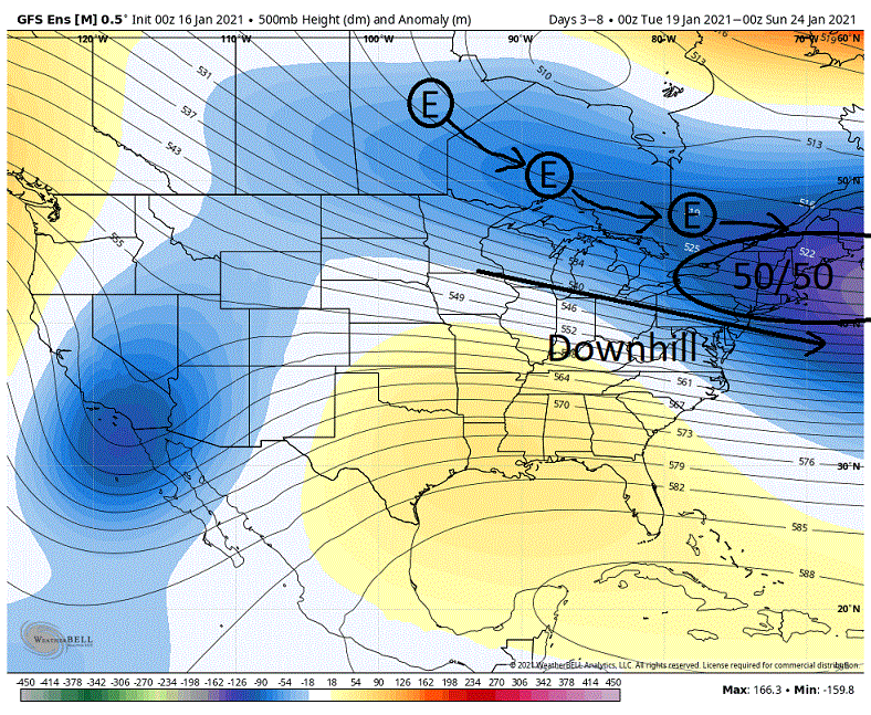
-
Central PA - Winter 2020/2021
showmethesnow replied to MAG5035's topic in Upstate New York/Pennsylvania
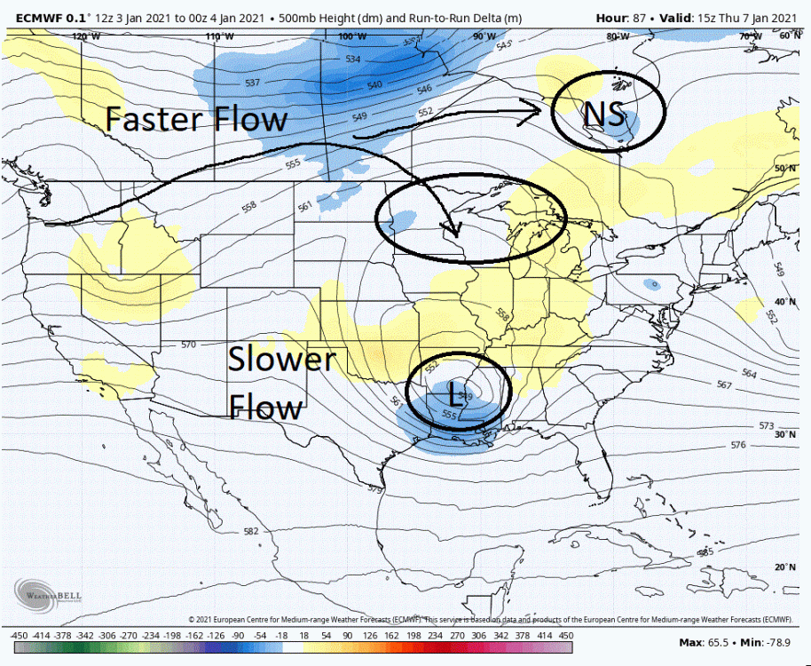
Looking over the 00Z runs gave me a serious case of the 'Blahs' for our chances this Fri/Sat (outside of NC/southern, eastern VA). Yesterday I threw up a possible winning solution for the mid-Atlantic and potentially farther north up the shores that I thought the Euro was suggesting the possibility of. But that required a bunch of things going right, especially with timing, placement and strength of the NS energy rotating down into the NE during a critical period of time. Essentially a Hail Mary. But with only 72 hours or so until this storm is on the coast, time is essentially running out to see the changes we need. And though there are some positives here and there, they are no where near what we need to see. Let's face it, when the 12K NAM, which is amp happy at range, is probably one of the more progressive model runs then you know you are in serious trouble. 4 or 5 days ago I started to bring up my concerns about what could possibly screw up up what I considered to be a pretty good setup for this time period. Though I have gone over it somewhat in previous posts I will do so once again in a little more detail for those that have neither seen these posts or are not clear on what is exactly going on. Below we are sitting at zero hr at 500s. Our forming storm is over Colorado and we have a 50/50 sitting in place. If you follow the lower pressure anomalies (Blues) tailing off from our 50/50 we can get an idea of its influence (suppression). This suppression is now pulling NEward pretty much in lockstep with our forming storm at a somewhat ideal distance. Not a bad look as the setup creates the needed ridging in front of our developing storm. But if you look up into southern Canada we see a piece of NS energy. Let's follow that NS energy. Almost a day later this energy is now sitting over the eastern Lakes. What it has done has dragged the suppression back westward. So where we were initially seeing good distance between the incoming storm and the suppression for developing the ridge, the distance has now shrunk. This is effectively beating down the once promising ridging. Though our chances for a storm that could possibly impact the mid-Atlantic (maybe somewhat north on the shores) took a serious hit just with this first piece of energy I do believe that we could have recovered with just a little bit of luck. Enter NS energy #2. The potential nail in the coffin. If you look below we see that the suppression created by the first piece of energy is now withdrawing NEward so we are once again seeing heights build in front of our storm. But if you look into northern Canada we now see another piece of energy dropping down. Almost a day later this energy is now sitting over the NE drawing the suppression, once again, back westward. At this point it is almost impossible to create the ridging we need to see as the distance between the suppression and the storm has been reduced significantly. And if you look at the ridging between it is basically getting squashed to death. So twice, when we needed to see a relax in the suppression for our storm chances, NS energy dropped down and reinforced that suppression. The first piece delivered the first blow that staggered us and the second delivered the knockout. Short of playing out a Rocky flick, where he gets up off the mat on the count of nine, I think the odds are extremely long that we can recover from this. I will give it another 24 hours. If I don't see what I want to see I will probably call time of death. After all, there is no point in beating a dead horse. ***I thought I would bring up another point. When to use the model ops vs. the ensembles. I am a very strong believer that you need to ride with the ensembles until at least day 5, sometimes even into day 3 depending on how complex the setup is. But there is one situation where the ops can play an important role in, roughly day 5-7. When we are looking at troughing in the east with a somewhat active NS. If we continue to see suppression through this time period (roughly day 5 through 7) on the op runs and yet the ensembles are showing a setup that argues that a system should run northward that should be a red flag to you. The ops with their finer resolution are better able to pick up on these smaller scale features (NS energy), whereas these features may get lost on the ensembles through lower resolution and the smoothing by the means. So if the ops continue to show suppression run after run, counter to the ensembles, then alarms should be going off in your head.***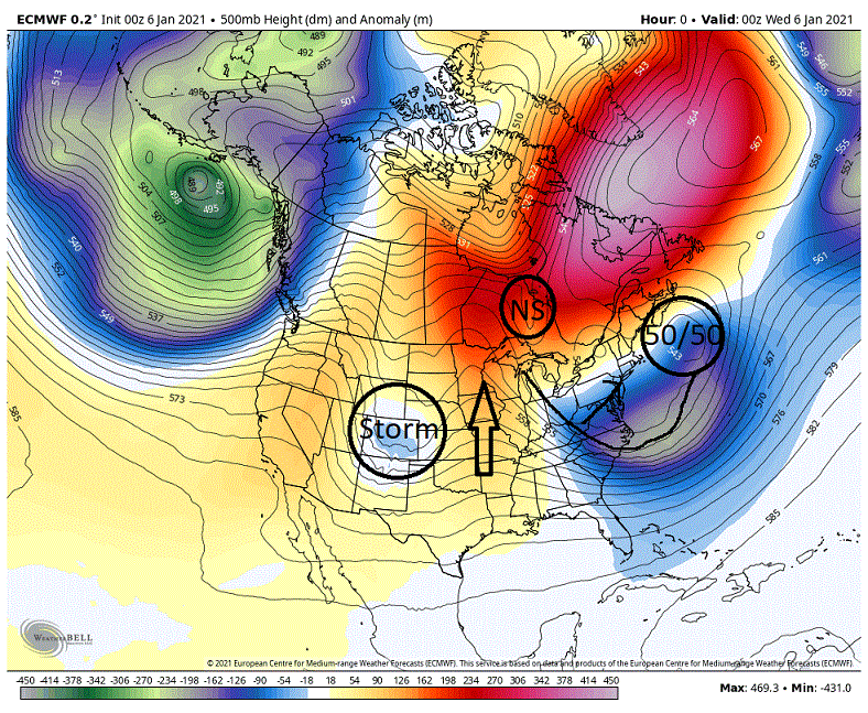
-
Central PA - Winter 2020/2021
showmethesnow replied to MAG5035's topic in Upstate New York/Pennsylvania
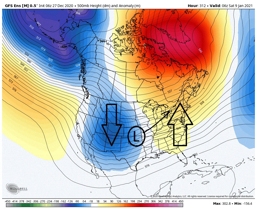
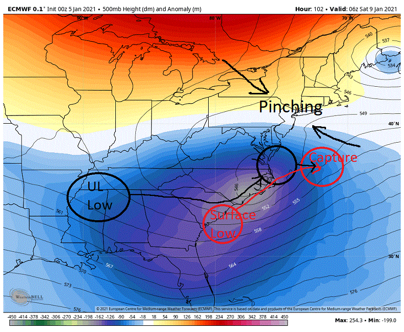
As they say, 'It isn't over until the fat lady sings' and with 3 1/2+ days for the Jan8/9th storm that is where we stand. And In my opinion the 00Z Euro run threw up a solution that was 'oh so close' to a win. Potentially a big win. Especially for portions of the Mid-Atlantic (N Va, Md, Del, Jersey shores) and even possibly somewhat farther north up the coast through the 95 corridor. What makes this possible is the differences we see with how it handles the NS energy dropping down from the 50/50 low. In blue below (00Z GFS run) I have what the models have generally been throwing up in recent runs. A strong piece of NS energy that is rotating down into the general upstate NY/NE region. Timing and placement of this feature is pretty much a no win situation as it drives the suppression too far south and west (blue dotted line) creating a storm that is suppressed and progressive in nature. But the overnight Euro has deviated from this general idea. It now shows a weaker feature (540 mb vs. 534 mb) which is displaced farther to the E/NE pulling the suppression farther E/NE (black dotted line). This changes the dynamics of what we see underneath with the upper levels and our forming storm. As we can see we have the upper level support over the Tenn. valley with the surface low on the SC coast. In front of all of this we are seeing some decent ridging forming (red arrow). The key here is to see that ridging form and maintain. The GFS with its farther south and west suppression in the NE is suppressing and eventually breaking down that ridging. But with the Euro's farther E/NE depiction of this suppression what is occurring is that this ridging is stronger and maintaining. Now let's play this forward somewhat with the better ridging to see how this evolves. Below we see the upper level support for our forming storm travels (black arrow) from the Tenn/Miss/Ala region directly eastward until it is approaching the coast and then shoots northward until it is situated around the mouth of the Chesp. Bay. This northward turn on the coast can mostly be attributed to the better ridging in front. Also note we have our surface low on the SC border which rides up the coast to around OBX (red arrow) and then moves out to sea. Again this northward pull of the coastal up the coast can mostly be attributed to the ridging. What we then see on this run is that the low stalls OTS and then waits for the upper level support to come in for a capture (red circle). Our objective here is to see this capture actually happen just off the coast somewhere between OBX and the Del Marva. We see this and then we are talking. The upper level support has good energy associated with it, good spin and lift. Get this to stack with the surface low and we have the potential for an explosive storm (overnight GFS shows this with a 30 mb drop in 24 hrs). But on this run below, the capture happens OTS and the dynamics have played out somewhat so we do not see this explosiveness. So once again we see a losing solution. But this was a hair away from a very good solution. If you note the tracks of both the 500s and the surface low they run parallel to each other on the N Carolina coast. And If you run through the different levels from the 500s down to the surface through this run up the coast you see that they are all running pretty close to lock step with each except there is a tilt northwestward as you run from the surface up to 500's. In fact looking at things I am a little surprised we didn't see the upper levels actually capture the surface through this time. But the fact that we didn't suggests the timing between these features was off a little. There is something else I would like to point out, something that could possible put into play those farther north in the coastal regions. Note the pinching of the isobars north of this system? What is occurring here is that the 500's are possibly making an attempt to close off this system and pull it out of the progressive west to east flow somewhat for a short period of time. I have to believe this is in response to the the different evolution of the NS energy that dropped in ahead of this system and is now located off the coast of NE. Instead of suppressing our storm, the timing and placement of this suppression is now in a position to possibly act as a road block to our developing storm to slow and/or stall it for a period of time. On this run we actually see the hints of this as the storm's progression around the Chesp. Bay gets bogged down somewhat. So what could it mean if the NS actually acts as a block and gets the upper levels to cut off and slow/stall for a period of time just off the coast? It means possibly, JACKPOT!!!! As I mentioned before, the fact we didn't see a capture of the low while it was moving up the coast could probably be attributed to the timing between the upper and surface levels being a little off. You slow or stall the evolution of the system and you create a larger window for a capture of this storm in a prime location for the Mid-Atlantic. And with the good energy we see associated with the upper levels the potential exists for an explosive storm as evidenced by the overnight GFS run. Throw in a dash of getting cut off from the flow along with a rapidly strengthening low and chances are we could see this pull northward somewhat putting NY or even Boston into play. Do I expect the above to happen? Not necessarily. After all, it is just one run, of one model. But what I do take away from this is that it shows that there are possible avenues to winning here despite what the models may be suggesting at this time. After all, 'It isn't over until the Fat lady sings'.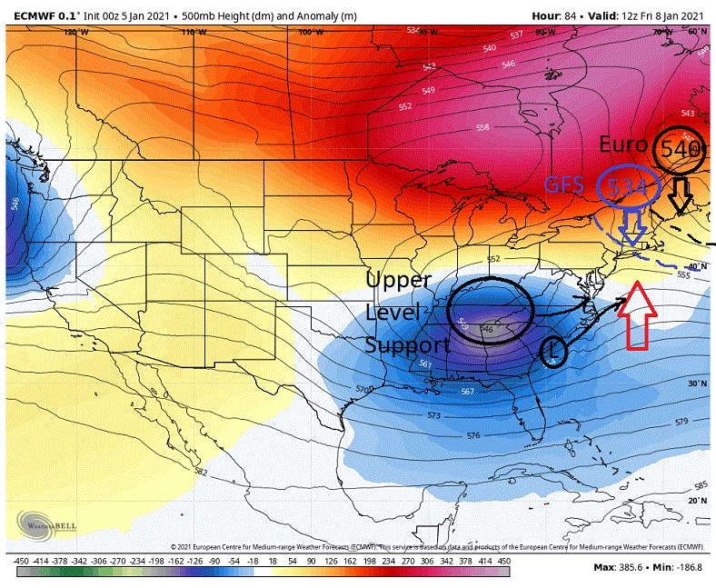
-
Central PA - Winter 2020/2021
showmethesnow replied to MAG5035's topic in Upstate New York/Pennsylvania
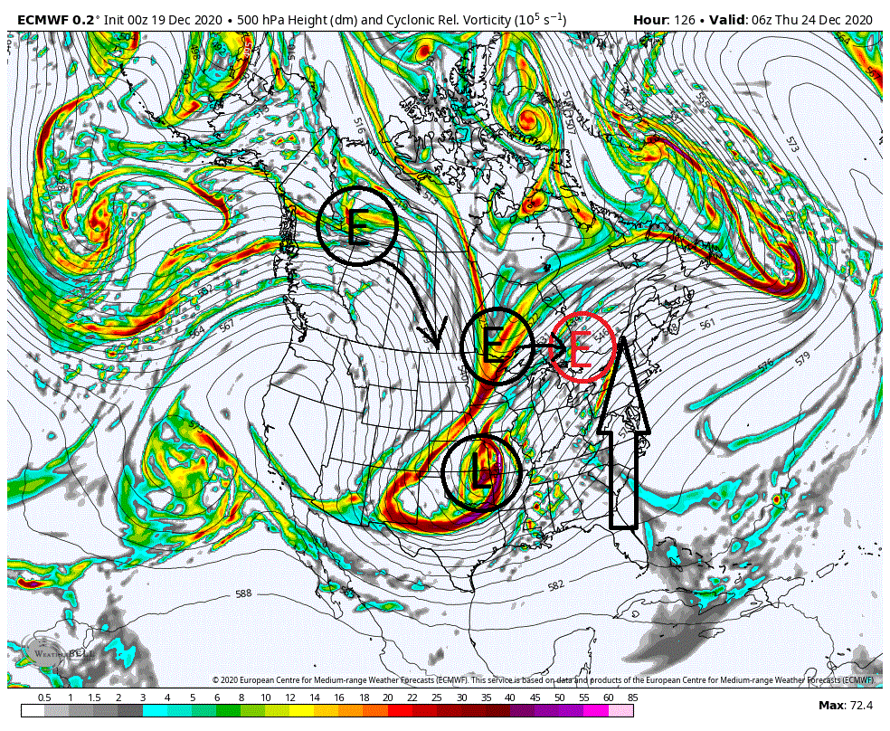
That energy you mention I did discuss. The first piece earlier is energy that has been rotating around the 50/50. The second piece that drops in to the NE is actually the NS energy that we saw from the split in the PAC NW. It has traveled across Canada where it bumps into the blocking created by the -NAO/50/50 combo and been inserted into the flow around the 50/50. -
Central PA - Winter 2020/2021
showmethesnow replied to MAG5035's topic in Upstate New York/Pennsylvania
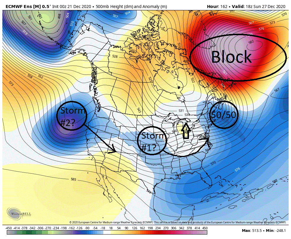
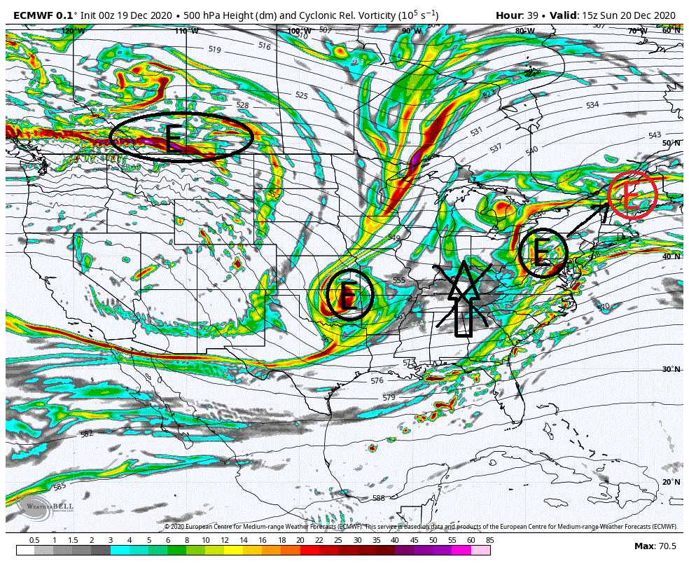
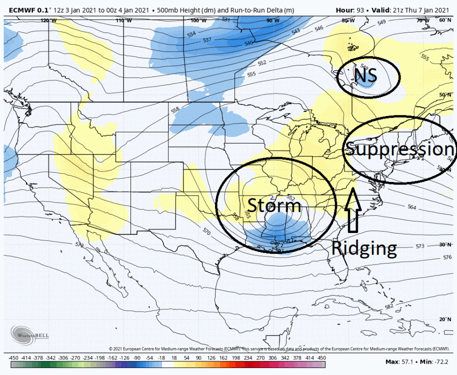
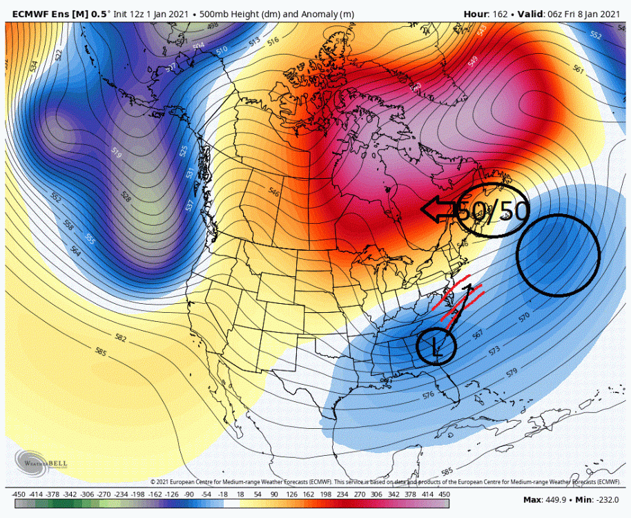
I mentioned yesterday that in my opinion, we wanted to see no involvement of NS energy into the setup for our potential storm Fri/Sat. I felt that the odds strongly favored that any involvement would result in a suppressed and progressive system. I think the overnight run of the Euro illustrates my concerns well. Below I am going to use the run over run pressure differences to help give you a sense of what is occurring. Below we have the time period roughly 2 days before the storm is located in the east. As we see we have the NS energy running through central Canada and energy located over Oklahoma. These two packets of energy are the result of a split of energy we see prior in the PAC NW. If you look at the southern energy (over Oklahoma) I would like you to note that we are seeing higher pressures (yellow) overtop the upper low and lower pressures (blue) to the south. This tells us that we have seen a deeper drop of this upper low on the 00Z run compared to the 18Z run. I will follow up on these features a little later. I want you to now look in the NE. What is occurring is that we are seeing a quicker relax of the suppression created by our 50/50 low. This is exactly what we want to see in front of the storm as this would allow the upper level energy for our forming storm to gain some northward latitude as low pressures desire to move poleward. This relax also helps to form all important ridging in front of the incoming system as well which would support northward gain as well. The stronger the low pressure, the stronger that desire. In this case with the suppression breaking down the impediment to this northward push is being removed. But here comes NS energy #1 that is rotating around the 50/50 low. So as the NE suppression is breaking down, we now have this energy rotating down that is now reinforcing and pulling the suppression back westward. So let's look at we are now seeing roughly a day later. As we can see suppression is in place in the NE from the reinforcement from NS energy #1. This suppression has knocked down the decent ridging we had begun to see prior, as well as offset the desire of the upper low to push northward as well. So not only haven't we seen a northward push of the upper level low, which has become fairly strong, but in fact it is even farther south. But once again the suppression is breaking down so we should start to see a northward push. But enter NS energy #2 that is the result of a split in NW PAC energy days prior. This energy is now dropping into the NE as well. Here we are a day later. Suppression is once again seen in the NE from NS energy #2. But now instead of being in front of the upper level energy for the storm it is now sitting overtop it. This suppression overtop is doing two things. Not only is it forcing this upper level energy south, it is also squashing it and weakening it. This is somewhat a critical stage in the evolution of the storm as around this time we should see the upper levels in the process of capturing and stacking to the surface low off the coast. This process would typically result in a somewhat rapidly deepening storm as well as a stronger desire for a northward push that would come along with that. But at this critical time we are now seeing the upper level support being severely weakened resulting in a weaker intensifying storm. And once again note that we are seeing higher heights (yellow) overtop this upper level low and lower to the south (blue) which signifies that out storm will be south from the prior run. I also want you to look at the flow running off the east coast, this argues the track of any storm will head out to sea as well. Nothing about this run gave me the warm and fuzzies for seeing our storm push northward beyond the southern mid-Atlantic. And all of this was created by NS interaction, twice. Now I know some would like to see NS involvement (phasing) for various reasons. Temps, track, strengthening, ect. I admit, a well placed and timed phase could help in these aspects as well as potentially setup a homerun. But as I see it the odds of seeing what we need to occur are extremely long given what is currently projected. First off, we probably do not want to see any NS energy rotate around the 50/50 and down into the NE in front of the storm. All this will do is create suppression when we need that to relax. But even if we see this, it doesn't mean it is game over. Depending on timing placement, strength, etc.. this is an obstacle we can overcome. But what probably can not be overcome is if we see any involvement of NS energy #2 formed from the splitting in the energy in the PAC NW. Let me explain why. If you see the circle I have drawn over the western lakes and westward this is where I consider we need to see any energy dropping for a potential phase to occur to be of benefit in the DC to New York corridor. Not only that but we need to see this drop exactly timed so as it is occurring when the southern energy has just passed underneath. This timing allows for the NS energy to dive down the backside of the lower latitude trough giving us a clean phase. Without this placement and timing we are more then likely SOL. Now despite the models now moving towards that NS energy moving through Canada instead of dropping into the central US, at one point it in prior runs they were suggesting it was possible. So for arguments sake let's just say it is still possible and we can get the drop we need. But this is the major hang up, timing. For any interaction from this NS energy we need to see it lag behind the southern energy so as any drop places it towards the backside of the trough. If this is in front or even directly overtop we will see suppressed and progressive storm. Given what is currently projected by the models I see no way that we can achieve the timing we need. From the get go (PAC NW split) the NS energy is out racing the southern energy as it is in a faster flow. Now sometimes this faster movement can be offset by energy traveling over longer stretches of real estate. But if you note there is not that great a distance to where the drop needs to occur so this more then likely would not factor in. The way I see it, the very best we could hope for in timing for the drop we need is to see that NS drop directly on top of the southern energy, which as mentioned before is a losing proposition. Now the models have moved towards taking that NS energy through Canada instead. So let's say we see follow up NS energy to replace that initial energy and despite the odds we see the drop and timing that we need to get a clean phase exactly where we need it. This is where that initial NS energy could screw us over as well. As I mentioned on the map above, this NS energy from the PAC split is now projected to drop down into the NE creating suppression at about the worst time. So we get the phase we need and yet it is now being squashed and suppressed as it moves eastward. And if we see that initial NS energy stay an intact entity as it moves across Canada the odds are pretty good that in fact it will be dropping down into the NE. The high latitude blocking argues for this. All of the above is predicated on what the models have been and are projecting at this time. Who is to say that 24/48 hours from now they are representing something else where some sort of NS involvement is actually a preferred and viable option. But at this time, I would just as soon have no NS involvement (especially that NS energy from the split) and roll with the general pattern outlined at this time. Otherwise I think the odds strongly favor we roll snake eyes for our storm chances through the DC/New York corridor.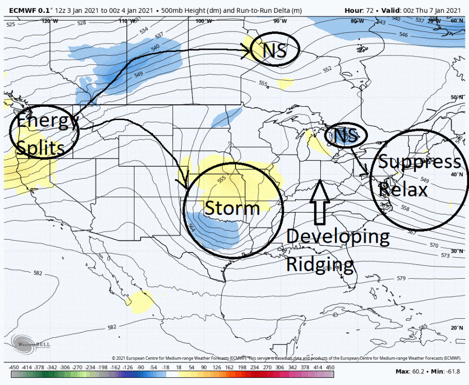
-
Central PA - Winter 2020/2021
showmethesnow replied to MAG5035's topic in Upstate New York/Pennsylvania
Though there are those that would argue this and call it sacrilege, I find a down and dirty way of getting idea if the pattern being represented out in time is favorable is to see what the snowfall maps have to show us. What I am seeing on the ensembles is quite encouraging as we are seeing a notable uptick in projected snowfall as well as an every increasing number of heavy hitters. I expect to see this given the very favorable pattern, and the fact we are seeing this on the models as well only bolsters my thoughts. Now this is not to say that the models are correct in their projections on the pattern in the extended. Just that they are seeing the potential if such a pattern in fact materializes. -
Central PA - Winter 2020/2021
showmethesnow replied to MAG5035's topic in Upstate New York/Pennsylvania
Just posted my thoughts on the Friday potential above. As far as the follow up there is potential there as well but what we see Friday will probably play a big part in that. -
Central PA - Winter 2020/2021
showmethesnow replied to MAG5035's topic in Upstate New York/Pennsylvania
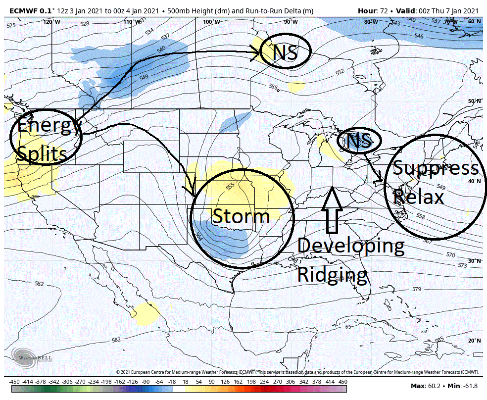
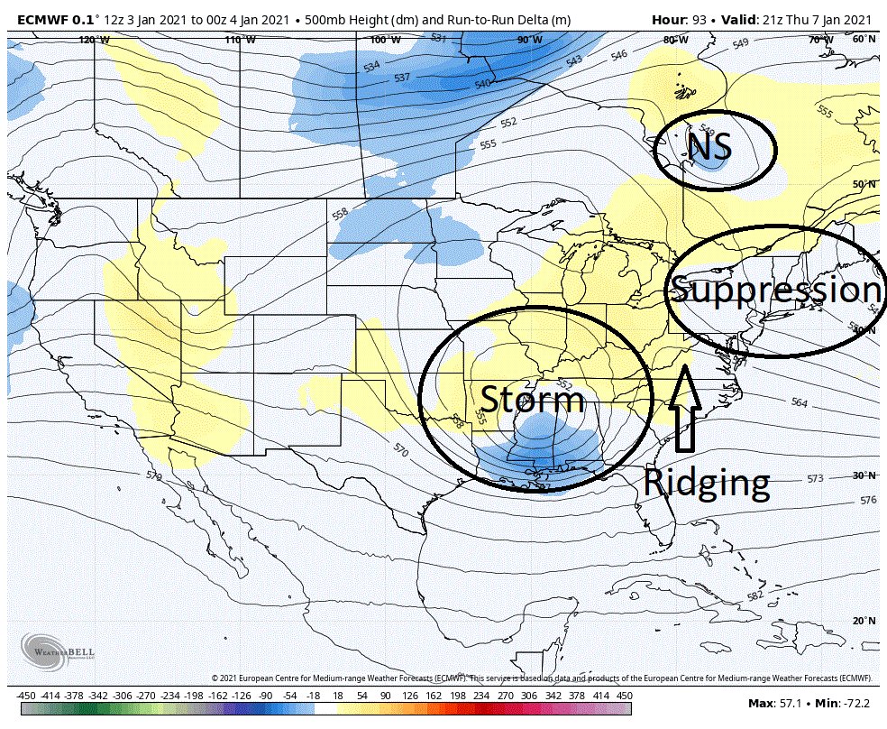
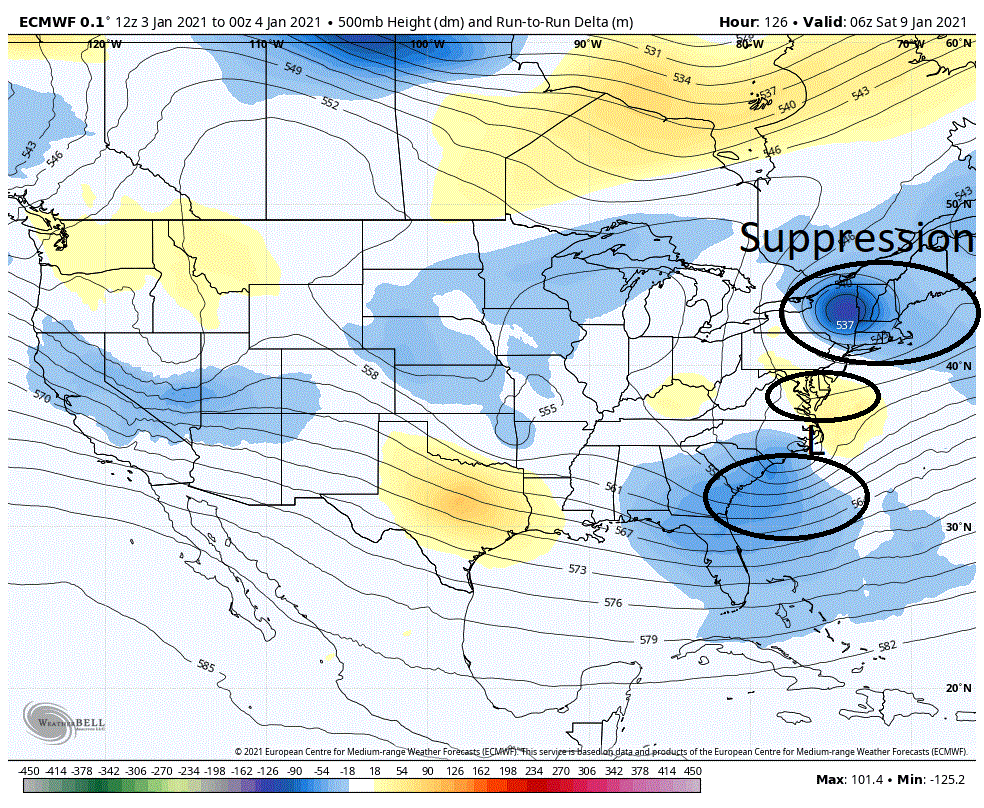
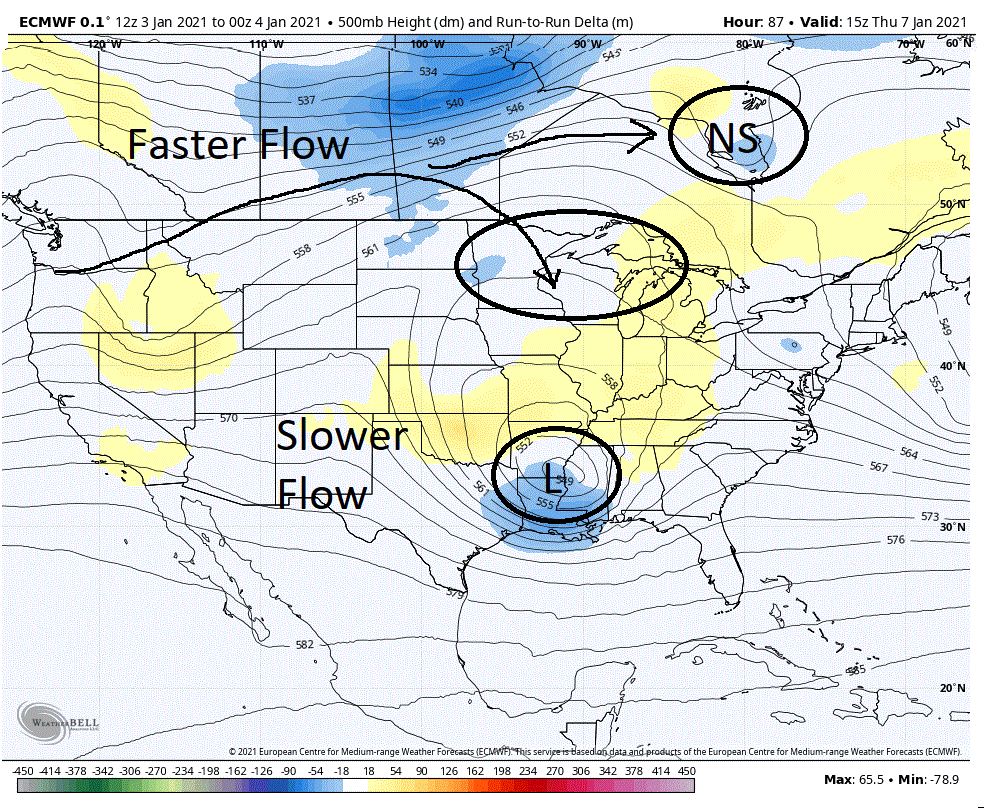
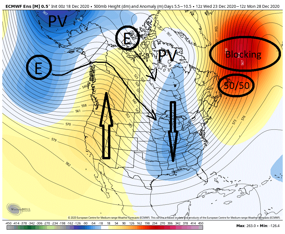
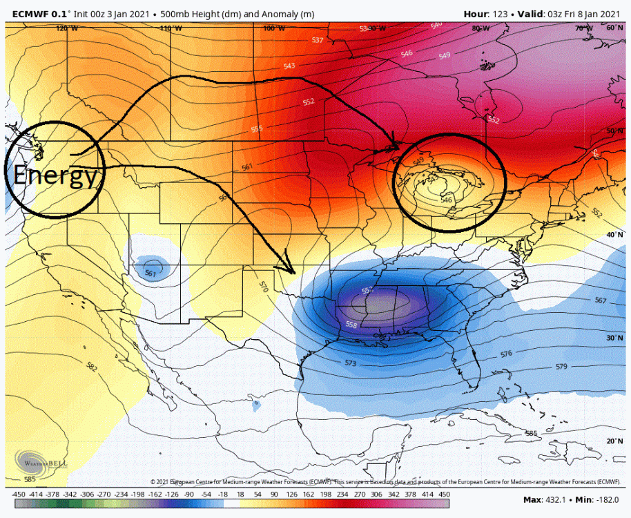
I spent a couple of hours yesterday morning writing up a post on the potential centered around the Jan 8th time frame. Unfortunately just before I went to post it I lost everything. Needless to say my puppies ran for cover and my wife scolded me for my ranting and foul language with yet another lecture on how I needed to save my work continuously. So, just another typical day for me. But I am here to try again. Fingers crossed. And yep, I will be saving my work continuously. I am going to use some maps I had drawn up yesterday. The general setup that intrigued me almost a week ago, a 50/50 getting locked in under a block for an extended period of time, has not changed whatsoever. This general setup argued that this was a period of interest for storminess in the east. But as we have neared in time and some finer details have emerged I have become much more interested. Below we have the general setup with a -NAO and 50/50 combo. What this does is back the flow upstream through the CONUS creating amplification with both ridging and troughing where it sets up a favorable track for energy moving eastward through the CONUS. Below we see this, as energy that entered the PAC northwest a couple days previously has moved eastward and taken a big drop southward with the amplifying trough into the Mississippi basin. Given the blocking in front of this system, this is actually positioned well for its move into the east. Now a further detail has emerged in the last few days that has has only increased my interest in this period. But before I go into that I want to mention something else. Some of our bigger storms are associated with the breakdown of a -NAO (senility is kicking in so the term escapes me at this time). What happens is that all the pressure created upstream from the -NAO/ 50/50 block is released as the flow in front of an incoming system quickly relaxes when the blocking breaks down. And like pulling a cork on a champagne bottle we see an explosive response, in this case a rapidly intensifying storm that will typically pull northward. A big part of this explosive response is actually associated with what we see occur with the 50/50 during this breakdown. The 50/50 plays a huge part in creating the backing of the flow. Take that feature out, as we see when it gets released during a breakdown of the blocking, and the pattern can relax quite rapidly. That said, back to the reason I brought this up. What the models have been keying on these last few days is that we will see a breakdown of this 50/50 through weakening and it withdrawing poleward. This is occurring generally in a favorable time period to impact our potential storm in the east. But with this evolution of the 50/50 we will see a slower relaxing of the flow. So instead of just releasing all the pressure at once as in the above example, the pressure will be released in a slower manner. What this should result in, is a system that will intensify somewhat rapidly and pull northward to a degree during this intensification before it meets resistance from the blocking that still exists. Now where the storm track in the east occurs will probably be dependent on when we actually see the breakdown of the 50/50 occur. Earlier and we probably see the storm track shifted north as the suppression to its east relaxes somewhat. This not only puts into play those areas to the north of the low as it tracks eastward but also potentially coastal areas even farther north somewhat as it intensifies and makes a move northward for a time. If we see the breakdown later in the process we will see this track shifted southward as the suppression in front continues. In this case the intensification and move northward will occur later in the process, more then likely OTS (out to sea). We have seen both scenarios above play out (and solutions in between) on the various operational runs the last few days. The northern extent being through the mid-Atlantic (roughly MD). with some impacts on the coastal regions farther north. As well as the southern sliders that are impacting in the southern mid-Atlantic all the way into N Carolina, with no play on the coastal regions to the north as the intensification and northward pull are occurring OTS. Though there are quite a few things I have been keeping an eye on there are a couple of things I have been keying on and that is what we are seeing with the influence of the 50/50 on the flow as well as any possible ridging between that 50/50 and our developing storm. Below we have an example of a southern slider. Now the influence from the 50/50 low will be determined by placement, how quickly it is withdrawing and track as well as the strength and how quickly it is weakening. That is a lot to factor in. So though it is somewhat crude I find the easiest way to determine the influence it is exerting is to look at the strength of the low pressure anomalies showing up to the south of the 50/50 as well as their placement. The stronger those anomalies, the stronger the suppression we will typically see in the east. Also the placement of those anomalies (east/west) in relation to the incoming trough will generally give you a feel of what to expect as far as any possible ridging that develops between these two features. First off, we note there is very little ridging showing up between the 50/50 and the incoming trough, which we do want to see. This would quite often imply that the trough and the 50/50's influence are too close/far to each other to allow/create height builds. But in this case I think the distance between the two features is fine so I don't think that is the reason for the lack of ridging. I think we have to look elsewhere. That elsewhere is in part, where we are actually seeing the physical representation of the 50/50 at this time which is suppressing the flow overtop. And in part, the stronger suppression in front of the system. One last thing, let's look at the 3 red lines I have drawn as I will use them as comparison in the follow up map. These lines give you a general idea of flow in the east and off the coast and thus the general track of any system. What we see here is not one we want to see as it is a suppressed and progressive look. This following map is a more northern solution of this system and actually not far from a winning one. I want you to compare this to what we see above. If we note the anomalies located to the south of the 50/50 they are coming in weaker. These weaker anomalies imply less suppression in front of the incoming system. We also are still seeing good separation between the incoming trough and the 50/50's influence though they have adjusted to the east a touch. I would also like to point out that the physical representation of the 50/50 has shifted east as well and along with it the suppression it was creating overtop. So let's look at what we have when we relax the suppression overtop and to the east and have good separation between the 50/50 and the incoming trough. If you look at the 3 red lines, that are comparable to the above map, we are in fact seeing ridging developing. We are also seeing an adjustment north as the suppression in front is relaxing. These lines also suggest that we would see a tucking in of a surface low to the coast as it amplifies and makes a northward jog for a time before it gets shunted out to sea. This is a much better look then the one above and not far from being a winning one for portions of the mid-Atlantic and up the coast somewhat. So what are my general thoughts on this system? I believe we do see a storm in the East. I also like the models having pretty much set up goal posts at this time from NC and OTS, up to MD and portions of the shores to the north. Both these options and ones between are still very much on the table given the setup. That said, I myself favor the northern solutions at this time. In fact, I would not be surprised if we actually see a solution that comes in slightly north of the northern goal post. I know some will fret the temps. But if we see the northern solutions play out I think many would find the temps would break favorably for various reasons, especially those west of the Fall line (95 corridor). I do want to throw one word of caution in here as well. There is one possible fly in the ointment. The GFS has suggested this possibility at times and the overnight Euro just threw it up as well. What I want you to focus on is the energy that is dropping down in the NS overtop the energy running to the south. What is happening is that the models are seeing a split in the energy when it enters the PAC NW. A piece is dropping southward and a piece is running through Canada. How the models handle that northern piece is crucial. If the models start keying on dropping that feature south of the Canada border then it is more then likely game over as there are very few good solutions that could come from that. What we would more then likely see is unfavorable suppression and/or a kicker that boots our developing system out. Either way we see a system that is too far south and is very progressive allowing no time for amplification.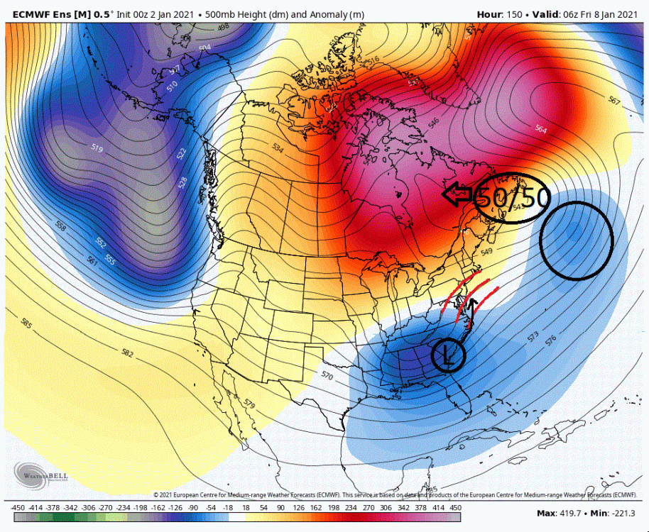
-
Central PA - Winter 2020/2021
showmethesnow replied to MAG5035's topic in Upstate New York/Pennsylvania
To be truthful, I pretty much lost interest when it became obvious that the upper level support (500mbs) would lag behind and along with it the cold we needed to help offset the crap airmass in place before the system. So I for the most part have been casually glancing at best and looking more beyond that to what that system may mean for the possibilities for around Friday. I might add, I like what I am seeing for Friday, IFFFFF the temps can cooperate. The setup at 500mb is primed for a potential MEC somewhere in the East as currently projected. But we are talking 7 days and there are things to be worked out first to see if we can realize that potential. But back to your original question. Outside of Northcentral and Northeastern PA I think most will be left wanting for any somewhat meaningful snow. This is excepting the coastal stalling and/or intensifying quicker which would change the equation. For those salivating over the NAM runs and their snowfall just remember they are at range. I myself think they are out to lunch here. The globals (GFS/Euro/CMC) probably have a more realistic snowfall presentation but even they are probably over done as well on the southern and western edges of the snowfall. But again, I haven't followed closely so take my thoughts for what they are worth. -
Central PA - Winter 2020/2021
showmethesnow replied to MAG5035's topic in Upstate New York/Pennsylvania
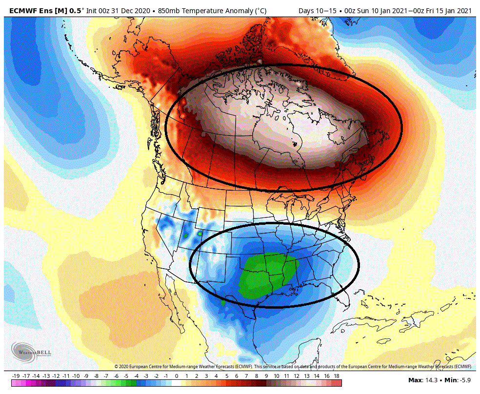
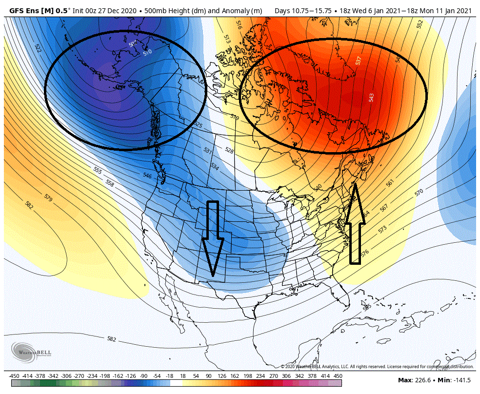
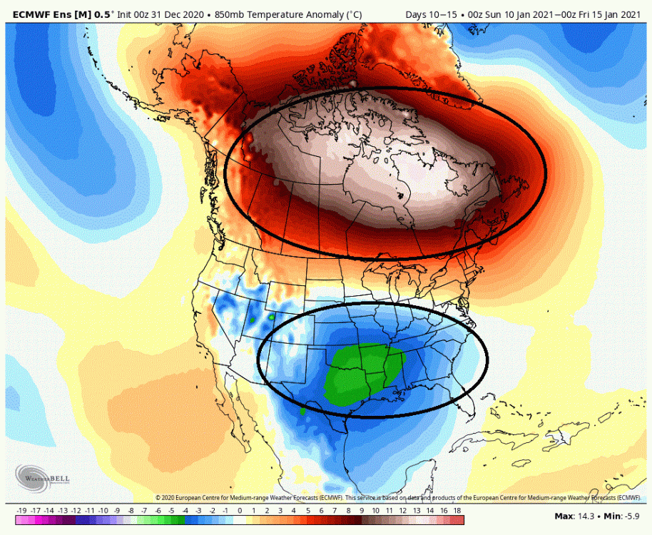
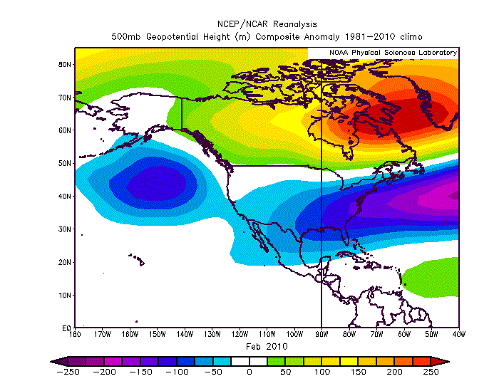
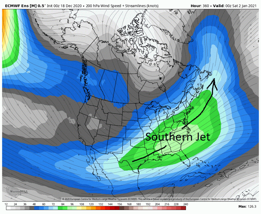
Admittedly my excitement level has increased this last week after each day of runs. But last night's run of the EPS has me over the moon. And the EPS is not on an island as both the GEFS and the CMC are extremely similar. When I see this, the whole of Canada torching with cold anomalies under riding it through almost the whole of the CONUS... And please, no references to how this sucks because our source region for cold air is on fire. Doesn't matter here. Then I see this... The PAC firehouse which has been blasting the west coast and overwhelming the flow through the CONUS is pulling westward and weakening in the extended. And the southern/subtropical jet, which has been active, is now aligning up and off the east coast and planting around day 10 in a very favorable local, all the while strengthening as we move forward in time. The two maps portend well for what we would actually see at 500 mbs. And they did not disappoint. I think we would be hard pressed to find a better look then what the EPS (and other models) are now throwing out. This is a seven day mean from day 8 to 15. As we can see there is massive blocking now projected over almost all of Canada. This will tend to force the storm track farther south through the CONUS. If you look over Alaska and was hinted at by the PAC jet, we see that the PV has shifted west so subsequently energy/storms revolving around it have shifted west as well. This is a favorable local as it will help to pump up heights in western Canada. In the western CONUS we now have ridging/higher heights from subtropical regions extending all the way up into Canada. The importance of this is twofold. It sets up a delivery of cold air into the central US which will be pushed eastward underneath the blocking through Canada. It also is playing a part in bumping up the southern jet from the Gulf and up the East coast which provides moisture as well as potentially injecting southern stream energy into any potential storm. As you can see, we have lower pressures over the southern states and the Gulf and it is exactly where we want to see them. If you note they are extending eastward trying to connect with lower pressures in the north Atlantic. This is a signature look for storminess in the east. You may say the lower pressures (pseudo 50/50) in the N-Atlantic are too far to the south and east for our needs. But no, in this case they are exactly where we want to see them when considering the given projected pattern. Now when it comes to snow there is always a degree of luck involved in the East. But really, this is a winning look for our chances. It doesn't get much better then this. If it wasn't exciting enough to see the above for the day 8 to 15 period, what really should excite you is that this will more then likely be a very stable pattern. This is a pattern that could potentially last for quite an extended period of time. So what would I expect given the above? In my opinion this argues for the axis of heaviest snow being centered around the mid-Atlantic. Somewhere between New York city down to Richmond. This could very well be a case where those in NE are smoking cirrus time and again, especially away from the coast, and those in DC/Balt/Philly are exhausted from shoveling 1-2+ feet of snow time and again. Now some people throw out comparisons to glorious previous winters at the drop of the hat. I don't. I believe that each winter is unique in its own way. So though there may be similarities there are also differences. Differences that can have a big say on the final outcome. That said, the similarities we are now seeing are striking to a previous winter. Dare I say 09/10? Below we have the mean for the month of Feb 2010. I want you to compare this to the above 7 day mean from the EPS. They are eerily similar. Now some may look at the lower pressure anomalies on the 7 day mean above and say it doesn't quite match up to Feb 2010. Let me just say, if we were to run that 7 day mean forward for another 2 1/2 weeks (to give us a full month) I would put good money that this is the look (lower pressures in the east and off the coast) we would end up with as the storminess kicked in. Now there is always a degree of luck involved when it comes to snow. But if the above projected pattern is in fact what we see, I very much like our chances as we are rolling with the equivalent of loaded dice that come up 7's almost every time.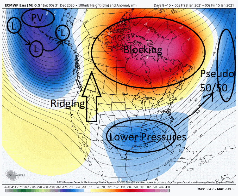
-
Central PA - Winter 2020/2021
showmethesnow replied to MAG5035's topic in Upstate New York/Pennsylvania
Going by the last couple of days of runs and ignoring the latest GFS run (06Z), the late Jan 3rd into 4th time frame might be worth keeping a casual eye on if the GFS and the Euro's current model depiction and players on the field at 500s are somewhat accurate leading into that time frame. It would be a case of, 'thread the needle' as it would depend on placement and timing between these different key features to overcome an unfavorable storm track within the general overall flow through the CONUS. This, 'thread the needle' scenario actually would have somewhat better odds then what we would typically expect as there are several evolutions of these key players that would be a win for some portions of the east, most of which probably favor portions of the mid-Atlantic and possibly up the coastal areas to the north somewhat. But the usual caveats apply here as we are talking op runs somewhat at range, with NS (north stream) features that the models are notorious for mishandling outside of 48/72 hours. Where just a minor adjustment in timing and/or placement can significantly change the evolution at 500's and consequently the surface reflection/low. In consideration of the above this could very well be a case of where the models don't really pick up on any potential storm until 24/48 hours before game time. Now, I am not calling for a snow storm, far from it. All I am doing is stating that I can see the potential. I might write up something in the next 24/48 hours if we are still seeing the same general setup they have at this time. Until then I won't waste my time on something that I currently consider low orders of probability. -
Central PA - Winter 2020/2021
showmethesnow replied to MAG5035's topic in Upstate New York/Pennsylvania
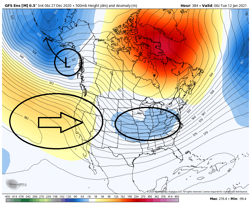
Debated somewhat on posting this as it is happens towards the end of the extended and it involves something that the models have mishandled quite often in prior years (energy dumping into the SW). So this setup could very well be a figment of the models imagination. This is day 16 on the 06Z GEFS. Now some will look at this and key on the lower heights in the central portion of the country and think there is a possibility there as this snapshot looks somewhat favorable. But short of well placed timing with short waves I think the odds strongly favor this once again being a cutter into the Lakes with possible redevelopment to the east as it encounters the blocking overtop. Any redevelopment would be far to the north as to where most would not benefit from any such redevelopment. And the reasonings for my thoughts are shown on the second map below. What we need to do is look at the evolution of this shortwave prior to the snapshot above. This is 72 hours prior. Note we are once again seeing what I discussed earlier this morning, energy driving down into the southwest bumping up heights in the East. So once again we should see the storm track adjusting to the N and W in the East. In fact this is exactly what we see when we look at surface pressures. What is potentially more significant is what we are seeing with the development of lower latitude ridging in the West, as well as what is occurring with the surface lows that have been prevalent in the Gulf of Alaska. What we are seeing with the ridging in the west is that it forms and then begins to move eastward starting to encroach in the southwestern US and connecting to the northern based +PNA and -EPO. We see this and it should effectively cut off the ability of energy from diving down into the SW from energy revolving around the PV. No Southwestern trough and we should not see the bumping up of ridging in the East which is creating our cutters. We see this look actually verify and move forward and we probably end up with a gradient pattern across the CONUS as strong heights (blocking) should develop across the whole of Southern Canada. Think bowling ball cutoff lows. Now whether temps would cooperate may be another story. And in that regard we are seeing a positive as well as we are seeing surface low pressures migrating from over the Gulf of Alaska into the Aleutian islands. If this look is real we could potential move fairly quickly into a very favorable pattern for at least portions of the East depending on where the boundary would set up. ***GEFS is more aggressive with this but EPS also has indications of this as well.***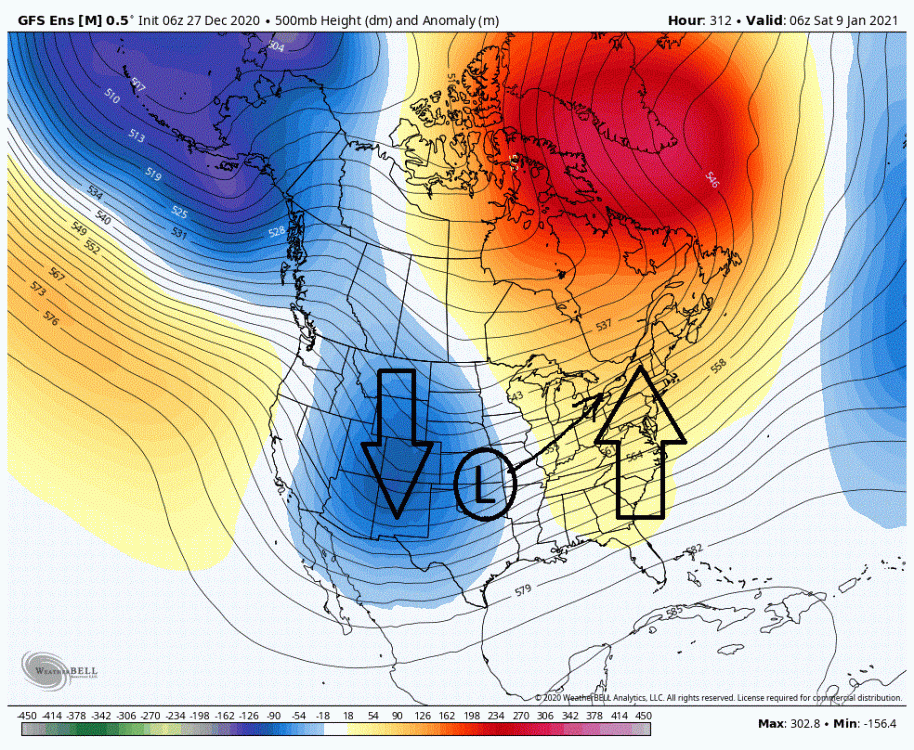
-
Central PA - Winter 2020/2021
showmethesnow replied to MAG5035's topic in Upstate New York/Pennsylvania
Now whether the models are portraying the impacts we are seeing from the Strat PV SSW/split correctly down into the lower levels can be debated. But what they are currently projecting is irritating as hell. If there are any questions as to whether a favorable N Atlantic can trump a hostile PAC what is currently being portrayed on the models should answer that question. Give me that blocking as currently projected on the 5 day mean in the extended and I would say 9 out of 10 times our snow chances would go fairly significantly up as it would tend to force a favorable storm track in the east. But what we are seeing from the PAC (strength, placement, configuration of 500 mb PV) is simply overwhelming the CONUS. Now we are seeing episodes of somewhat decent spiking with the EPO and northern PNA (North stream driven) which would generally be favorable for in the East as to wavelength and the ability to drive cold into the East. But the portrayal of the 500 PV and how it is configured it is not allowing for the creation of any decent cold air on our side of the globe nor the tapping into of decent cold air from the other side of the globe through cross polar flow. But still, considering the time of the year this is something we could potentially overcome. But what we are seeing with the mid-latitude flow is overwhelming this. As you can see we have that big blob of blue around Alaska which is the PV. What I want you to note are the blue anomalies that extend down from that feature into the SW and into the west central portion of the US into the lower latitudes. This is signaling that we are seeing energy diving into the west creating episodes of troughing which results in a corresponding response of ridging in the East and off the coast (WAR, Western Atlantic Ridging). I am sure most of you have noted the recent tendency for strong East coast ridging popping up in front of incoming systems driving the systems into the Lakes. This look below argues for a continuation of this general storm track though it may be adjusted somewhat southward as we are seeing better blocking overtop (putting the farther north latitudes in the East more so into play). So how could we possibly get those farther south into any possible action? The favored way is if we see those strong positive height anomalies in the western Nao domain shifted farther south towards southern Canada. This would shift the storm track southward as well. Besides that, we are highly dependent on timing of different smaller scale features to drag the boundary farther south in advance of any incoming systems. Depending on timing though, is quite often a losing proposition for most of us.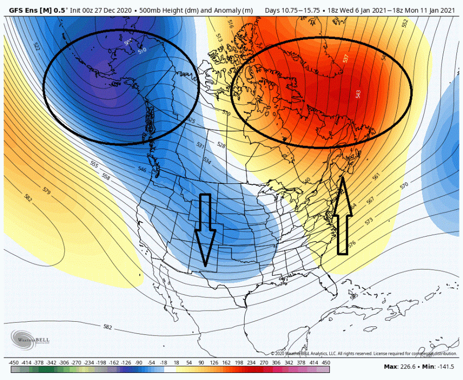
-
Central PA - Winter 2020/2021
showmethesnow replied to MAG5035's topic in Upstate New York/Pennsylvania
I am still excited about what we are seeing despite what we may have with the next few systems. It looks as if the N-Atlantic is going to cooperate (blocking) for the most part for the foreseeable future. This portends well for seeing blocking a good portion of the winter. As long as we see that blocking, no matter where it is located, we will have our chances. As we are just entering prime climo this should hopefully afford us ample opportunities this winter. I really think this is a case of delayed but nor denied. -
Central PA - Winter 2020/2021
showmethesnow replied to MAG5035's topic in Upstate New York/Pennsylvania
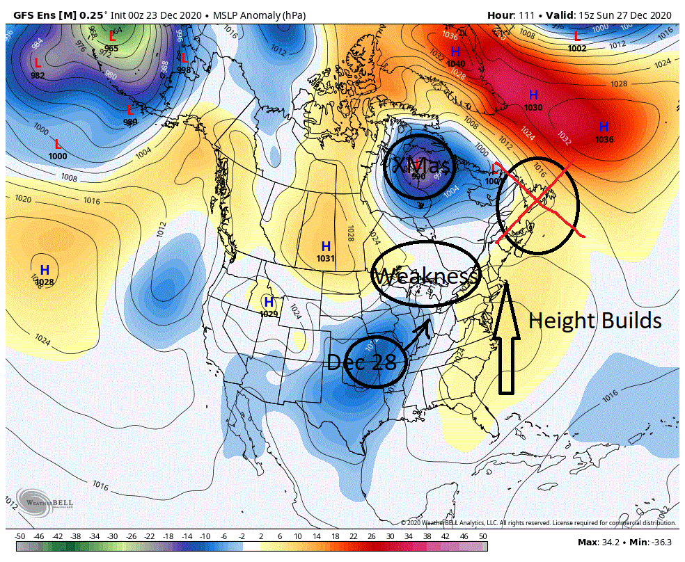
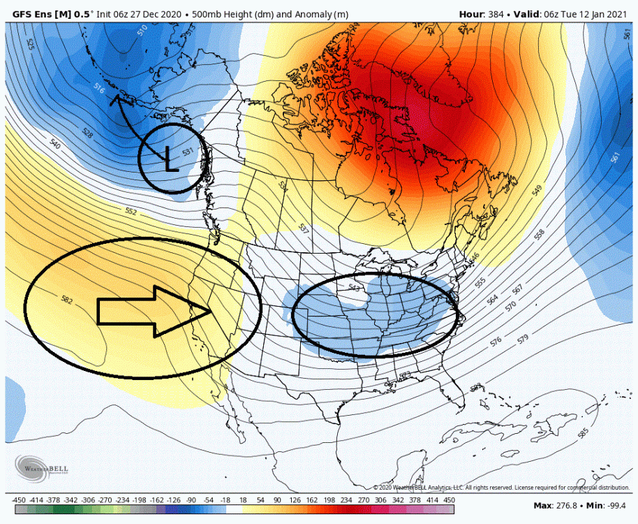
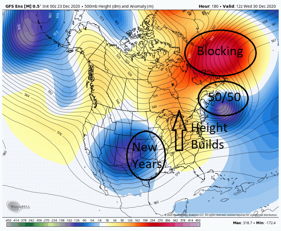
As far as our first system (Dec 28/29) after the Christmas day storm I think that is pretty much DOA for the majority of the mid-Atlantic outside of those possibly around the lakes and the extreme NE. The Christmas day storm would have been the setup for system #1 and we aren't seeing what we needed to see. A few days ago the models were portraying low pressures around the 50/50 region. We are no longer seeing that as we now have them located up around the Hudson Bay region. This difference is allowing height builds up and off the east coast in front of system #1 and also creating a weakness over top through the Lakes as well. This pretty much argues that this system will ride up into the Lakes. Now this first system was somewhat of a reach to see snow of any consequence into the 95 corridor/coastal plain in the mid-Atlantic up into the NE as portrayed on the models a few days ago. What was of more significance was that it laid the groundwork for system #2 around the New Year. But like dominoes falling, system #2 is now in serious trouble as well because of the difference in evolution of the Christmas day storm. This is the look we are now generally seeing on all three major Global ensembles (Euro, GFS, CMC) leading into system #2. All three globals show our Dec 28th system migrating into the general 50/50 region underneath blocking in the NAO region. This is pretty much what we want to see. But if you look in between that 50/50 and our New Year's day storm note that we are seeing strong height builds/ridging running up in the east from the deep south into Canada. Now typically I want to see height builds between a 50/50 and an incoming low. But I want to see them at the last second as the approaching low closes the distance to the 50/50. But we are not seeing this here as the height builds are occurring far too early because of the large separation between these two lows. And the reason for this large separation is two fold. The different evolution of the two previous systems has changed the timing and the South west energy is a little slower to eject. This really is not a good look as it wrecks temps (warming) and effects storm track (adjusting it north and west). Now I have not given up completely on system #2 for the 95/coastal plain as of yet, but it is looking rough as currently portrayed on the models. We need to some how delay/tamp down those east coast height builds whether through timing or other means. Some may ask why we are having such difficulties despite good blocking showing up in the N-Atlantic. That pretty much has to do with where that blocking is showing up. Typically (there are exceptions) for the coastal plains/95 portions of the east we want a western based -NAO that extends over top into Canada. But what we have been generally seeing has been an central and eastern based -NAO. There is hope though as there are signs we are actually moving more towards a western based NAO in the extended. Guess we shall see.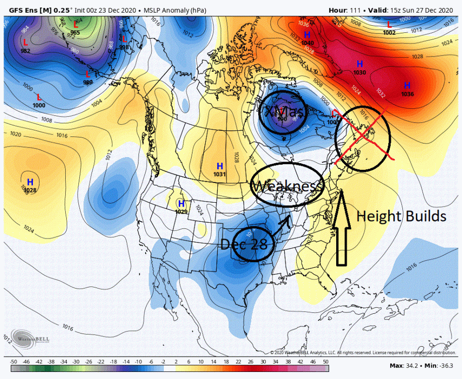
-
Central PA - Winter 2020/2021
showmethesnow replied to MAG5035's topic in Upstate New York/Pennsylvania
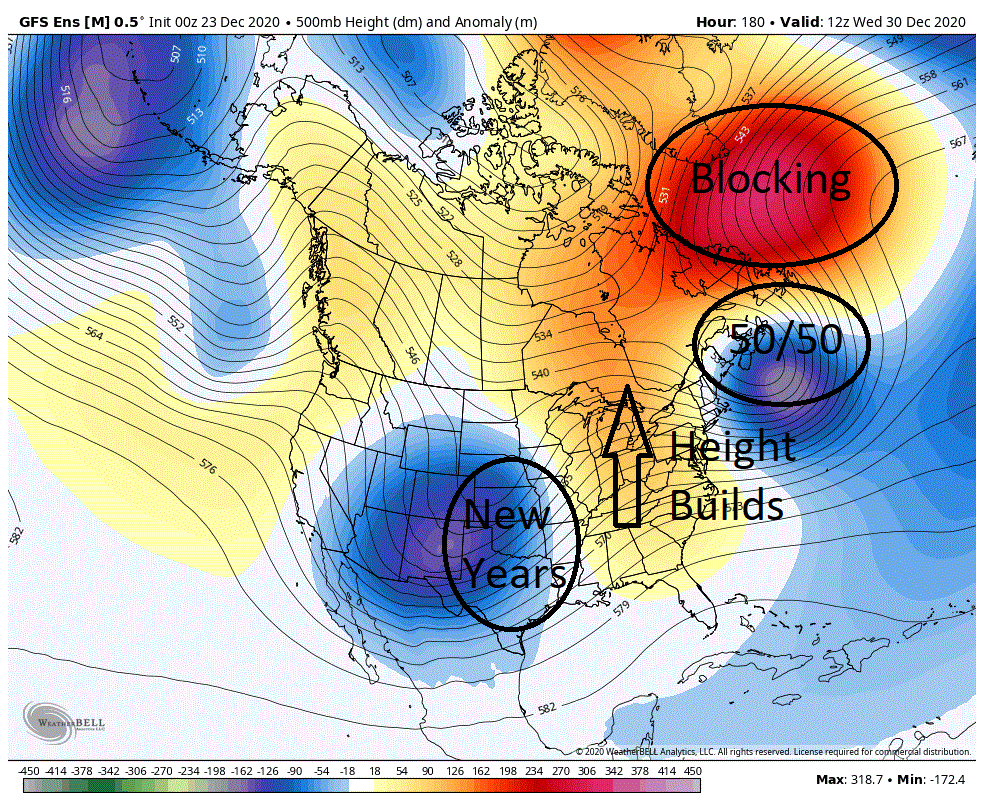
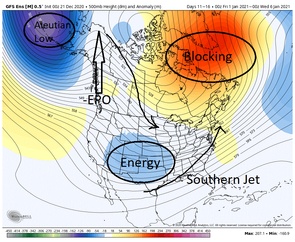
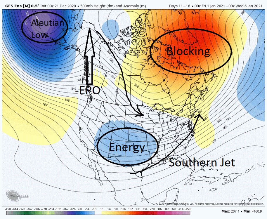
When I see this, it is hard not to get excited. This is a pattern that has the potential to deliver winter in a big way for many in the East. The only ones that could potentially lose out would those further north towards New England as the blocking forces the storm track too far south. What we have below is the 5 day mean (day 11-16) from the overnight GEFS. This is the pattern that we are currently transitioning to and gets locked in and looks to have some staying power shortly after our Christmas storm. We are seeing this general look on all 3 major globals (EPS, GEFS, CMC). What we are seeing is major blocking getting established within the NAO domain (-NAO) which tends to establish troughing in the East and the favorable storm track that comes along with it. To the West we see ridging up through Alaska (-EPO). This is the mechanism to drive cold air into the central portion of the CONUS. Quite often times we will see quick hitting cold shots into the central portion of the country that quickly retreat back into Canada with a -EPO, with only glancing blows in the East. But with the blocking we are seeing this will help to shunt the cold eastward as well as to help lock in the cold. To the west of the -EPO we are seeing an Aleutian low being established. This feature helps to pump energy into the northern and mid-latitude jets from storms that are rotating around it, energy that potentially become our future storms. In the south we are seeing lower heights showing up in the general Texas/New Mexico region. This implies southern energy will be in the mix to possibly seed storms as well. One thing that is not shown is that we are seeing a southern/subtropical jet setting up and having staying power shortly after Christmas, from the deep south/gulf and up off the east coast. This feature would have the ability to provide ample moisture to any storms in the east. What we have here are all the ingredients for a possibly very memorable stretch of winter for some/many in the East. But the devil is in the details, so let's see how this plays out. I did want to bring up something I alluded to a few days ago. And that was the potential shortly after Christmas. As we near in time to this period and details start emerging I am getting a little more enthusiastic about the prospects. Below we have the 500mb map from the EPS for Sunday the 27th. Both the GEFS and the GEPS also show very similar setups as well. As you can see we have blocking in the NAO region. What we have below that feature is the Christmas day storm that has now rotated up into the 50/50 region and is getting locked in for a period of time. What we are concerned with is the energy/SW located in the central US. As we see this energy move eastward and it closes the gap with the 50/50 low we will see ridging develop between the two systems which will create initial dig from the energy in the central US. This dig will cease once the SW and associated trough start going negative tilt and the storm starts amplifying which will create the desire for the storm to move northward. So what we should see is a storm that digs somewhat into the south and then starts riding northward. Now most times we are concerned about timing between the lead shortwave (50/50 low) and the developing storm as to storm track or even if a storm of any consequence develops at all. If the models are correct this is not so much the case here. What we see here is the 50/50 low gets locked in for a period of time so what will be key here is more so the placement of where it gets locked in then any timing concerns as far as storm track. At this time I am getting somewhat confident we will see a storm in the East (centered roughly around the 28th) and it is more a matter of where the 50/50 sets up as to where the storm track will be. Besides the models being wrong, about the only fly in the ointment to this storm would be with the energy we see off the West coast. If this energy rides too close on the heals of our possible storm then it could/would screw things up. Now about the energy that we see off the West coast. Could we be talking a one, two punch as we see another follow up storm 2/3 days later? If we don't see that energy take an extended stay in the South West or move eastward on the heals of storm #1 I like our prospects for a second storm.
-
Central PA - Winter 2020/2021
showmethesnow replied to MAG5035's topic in Upstate New York/Pennsylvania
I am not a big fan of anafront snows. Far more often then not they fail to deliver what the models promise. The stars have to pretty much align to get anything somewhat meaningful (in 50+ years I can probably count on 1 hand where there was anything noteworthy). The problem we face is that the cold that is typically tapped into is anywhere from our W to the N. So to draw this cold in we need the winds at lower levels to shift from somewhere in these general directions. When this happens we become under the influence of down sloping which quickly dries out the lower levels of the atmosphere as it heads towards the coastal plain. Now I am more familiar with southern PA and MD so I can't speak so much for central and northern PA. There may be other considerations there. But to answer your question. I am not really enamored with the setup for post frontal snows for Christmas. I think the models are once again overplaying the potential. -
Central PA - Winter 2020/2021
showmethesnow replied to MAG5035's topic in Upstate New York/Pennsylvania
@Blizzard of 93 I know the models have been teasing us with the possibility of anafront snows for around Christmas. For most of us that is quite often time fools gold outside of those that may have the benefit of elevation, latitude and/or Lake influences. The models just do not handle that setup well as they often times hold onto the moisture post frontal when in fact it gets shut off much sooner. That said I do see several possibilities. Possibilities that could be more impactful as far as our snow chances vs. the ana-front snows. At this time with what is currently depicted they mostly revolve around what we see with the energy over N Minnesota. The problem we have currently is that we see massive ridging running up the east coast in front of the developing storm. Pretty much a non-starter for our snow chances in the east except for anafront snows. But there is a solution to this problem and it is on the table. If you note we have energy running over top, in N Minnesota, of the storm and the deep trough it is embedded in. Right now per the models this energy is being influenced by this trough and being drawn into it. But if in fact we were to see this energy out race this trough eastward (red circle) it would change the dynamics of the setup fairly significantly. Instead of this energy dumping into the trough helping to pump up the ridging in front of the storm it would instead help to knockdown the heights in the east. This would put into play several possibilities and they mostly involve the trailing energy we see in the Pacific NW. We are sitting at 5+ days days in model land so there is plenty of time to see the changes we need, especially when it involves NS/PV energy which the models quite often times mishandle (timing/placement) outside of 2/3 days. In fact looking over the most recent runs I am seeing a tendency for the models to be quicker with this NS feature (over Minn.). So for those hoping for a Christmas miracle (or shortly thereafter) I wouldn't give up just yet. Let's see where we stand at 3 days out. It may surprise.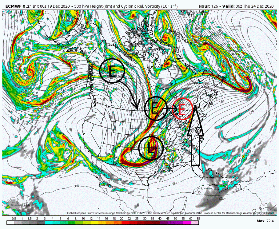
-
Central PA - Winter 2020/2021
showmethesnow replied to MAG5035's topic in Upstate New York/Pennsylvania
I know some on these boards are holding out hope for this Mon/Tues timeframe for in the east. I myself don't see it with what is being currently being depicted on the models and think time has pretty much run out to see the changes we need to. Below we have the vort map at 500's leading into that time period. As you can note we are seeing a fairly vigorous short wave over Oklahoma which is the focus of any potential storm. The problem we have here is we are not seeing enough separation between the two to see what we need to see. What is occurring is that the lead SW (mid-Atlantic) is suppressing the flow behind it and not allowing any ridging to develop in front of the energy trailing behind it (note the flat isobars between these two features). That trailing energy needs some form of ridging in front to allow it to turn and amplify. But instead it is encountering suppression which is squashing it and stringing out the energy where we lose any spin in the atmosphere. This is why we are seeing a broad area of lower pressures running up the east coast from the gulf with no clearly defined low pressure as there is just nothing in the mid-levels for the surface to focus on. Now if you refuse to give up there is one thing you can root for. Hope that the front running energy over the Mid-Atlantic is 12+ hours quicker (red circle over NE). This separation would allow some form of ridging to develop allowing the SW axis to turn towards a neutral/negative state instead of being squashed. The greater the separation the better the turning of the axis. If we would see this it would not only provide something for the surface to key on but it also possibly puts into play the trailing energy we see just north of Nebraska. Right now it is more a hinderance to any possible storm development but put in place a better defined neutral/negative tilted SW in front of it and it could potentially become a player as chances are decent we would see a better drop from that feature where it could possibly be put into play.
-
Central PA - Winter 2020/2021
showmethesnow replied to MAG5035's topic in Upstate New York/Pennsylvania
Not sure about everyone else but what I am seeing on the models recently as we head into prime climo has me stoked for our snow chances from the mid-Atlantic up into the NE. Below is a 5 day mean from the Euro that shows the general pattern we are moving into and which looks to have some staying power. We are seeing a PV setting up over the northern Hudson Bay as well as over the Aleutian Islands. This configuration is forcing the pattern through the mid-latitudes as to we are seeing ridging in the west and troughing in the east. The placement of these features are almost ideal as we see the ridging just west of Idaho and the troughing showing a neutral state through the Mississippi valley.. Around both these features we are also seeing a steady stream of energy rotating around them to either amplify on their own or to phase. Not to be outdone we are seeing the N Atlantic cooperate as we are seeing blocking setting up and maintaining. This is a money look to me. Now some might look at this and go, 'But it doesn't show any signs of a 50/50 low!' and they would be right. But I could almost guarantee that with what we are seeing here we would see lows running through and getting locked in for periods of time in the general 50/50 region with this setup. These lows would come from either the PV, which is well placed over the N Hudson Bay and aligned to send lows into that region or mid-latitude lows as they amplify in the east. As they say in the movie Field of Dreams, 'Build it and they will come', if you build that N-Atlantic blocking the 50/50 lows will come. One thing that is not represented in the below map is what we are seeing with the southern stream. What we are seeing there is very promising as well. We are seeing a continuous bumping up and amplification of that from out of the gulf and up the East Coast throughout the period. This not only provides a possible moisture feed for any developing storms in the mid-latitudes but also puts on the table phasing as well as potential true blue Miller A's. If this is what the base state (after any relaxes) will look like for a majority of the winter I think that many in the East will be happy with the results. Now I do not want to dismiss the coming 10 days as I think there are opportunities showing up and it will be a matter of timing and placement of the energy streaming through the CONUS, but beyond day 10 has my interest somewhat. I am seeing indications of the possibility of a big East coast storm beyond day 10. Though the hints are somewhat subtle on other maps, what we are seeing with the southern jet is somewhat noteworthy. We see shortly after day 10, the southern stream setting up from the south and running up the east coast throughout the extended. Not only that it is a strong signal as well when you consider a couple of things. First off we are talking the extended, so features get muted and washed out as individual members on the ensembles go their own way the further out in time you go. And second we are talking the tropical jet which resides more towards the 300 mb domain then the 200 mb which is represented on this map. So the fact that the 200 mb's is picking up on it fairly strongly is probably suggestive of a very strong jet. So what does this all mean? It means that the jet is honking the possibility of a strong system running through the south and then turning up the coast.
-
The Reaper paid off the Snow Gods.
-
@psuhoffman Seeing as the mid/long range model thread has transitioned overnight into the Lawn and Garden thread I finally had a chance to look over this thread somewhat. Very nice work and very labor intensive I am sure. One thing I did notice with your Index breakdown for our storms is that what many consider the Holy Grail of our PAC look (-EPO, +PNA) for snow maybe isn't so much the look we really want to see for our best odds. Looking at the breakdown of the +PNA/-EPO regime we are only seeing 14 storms vs. 25 storms for a -EPO/-PNA regime. A +EPO/+PNA features 19 storms and even the polar opposite (+EPO/-PNA) is only marginally worse with 11 storms. But consider this. Maybe our ideal look isn't so much with what we see with the PNA index but more so on having an -EPO and where its placement is. Thinking it through I think if you looked at the -EPO storms in both a -PNA and +PNA regime we would find that a strong majority actually were very similar. And that is with featuring an eastern based EPO ridge that was encroaching into the PNA domain. What I often call a northern based +PNA over cutting troughing into the SW. Now if this is the case then many of these storms probably featured a weak +PNA or -PNA (close to a neutral state) depending on how far into the northern PNA domain the EPO was encroaching. Now I don't have your data so I can't really delve into this without quite a bit of effort but I was wondering if it was somewhat easy for you to do could you possibly throw up the number of storms we actually saw with a -EPO and a weak +/-/neutral PNA? Maybe a composite of those storms as well? One last thing. You didn't by chance get composites of the looks we were seeing 3/5/7 days in advance of these different regimes? If you haven't please don't spend the time. I will just make it a project over the summer when I get bored of tracking Fail after Fail with severe and tropical.
-
The Seasonal Snowfall Futility Markers
showmethesnow replied to North Balti Zen's topic in Mid Atlantic
What's being provided? Brunch or Continental Breakfast? -
I like what we are generally seeing in the longer ranges on the EPS and GEFS as it does have potential. But we will probably be dependent on well timed systems and/or episodes of some sort of blocking in the N Atlantic to realize this potential. Otherwise we are running the risk of progressive and suppressed systems. On the other hand we are seeing an active southern stream that could very well come into play as well. I would definitely roll the dice on what we are seeing now as there is very good upside if things break right for us. And it sure beats what we were looking at just a few weeks ago.
-
Let's see where we are in a day or two. But as of right now with what is being depicted I wouldn't expect to see any transfer to off our general coast as the primary is still gaining too much latitude. See stronger heights in Canada on future runs with less latitude gain and/or a deeper dropping trough then we can probably start considering the idea.