

ariof
-
Posts
674 -
Joined
-
Last visited
Content Type
Profiles
Blogs
Forums
American Weather
Media Demo
Store
Gallery
Everything posted by ariof
-
This is a great data viz of the reservoirs and snowpack in California. They're still coasting on a series of good winters and the reservoirs started high.
-
Feb so far: Highs: BOS: 32 OWD: 32.3 BED: 31.0 Lows: BOS: 18.0 OWD: 4.5 BED: 6.2
-
It felt cold after Feb '18, the last two weeks of which had nearly as many days in Boston above 70 (2) as below 30 (two days in the upper 20s). March was a -1.1 anomaly, which put it 1° colder than February, overall, and other than the first day and the last few, it didn't hit 50° in Boston all month. 21" of snow at BOS, 42 at ORH, and I think Mitch got about 18 feet.
-
It's been a great year for xc, which relies almost entirely on natural snow. Aside from a couple of days post-Grinch right before xmas, there's been good-to-excellent skiing in most of CNE/NNE, and since late Jan, in SNE as well. Tickets are much cheaper, and in many cases groomed trails are free to use.
-
Back to -SN in Kendall Square. VIS to the west is unlimited, but to the east is about 3SM. Ground slightly whitened.
-
That's to nice to that one. Shoot it into the sun. I remember sitting under heavy echoes with nothing coming out of the sky, laughing/crying at all the schools/events/workplaces which were canceled 36h in advance. In particular the schools which closed on Sunday evening for Tuesday, or, worse, on Monday morning after it became quite clear that the storm was going to bust hard. A big, late enough shift that the BOX forecaster was surprised in the AFD. And this forum didn't even have time to make a toaster run.
-
As was the 06 GFS.
-
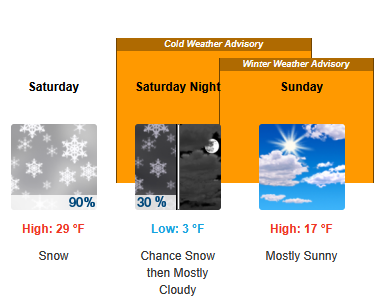
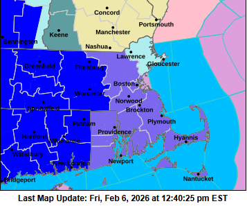
BOS has advisories up, WWA for the CWA east of ORH county, Watch for Essex County. But because of the hierarchy of products, the watch is behind the cold weather advisory for Essex County, so it doesn't show up there. I think they coded the times wrong, too, they're showing the WWA for Sunday (the Watch is timed correctly).
-
They said in their AFD that they were waiting for the hi res models to come in this morning. Given the trends they'll probably put up WWAs across the region, and maybe even a WSW for Essex County.
-
The surface low on Thursday at 00Z went from the benchmark at 06Z to YBG at 12Z. What's 600 miles between friends/model runs.
-
Back to -SN in Kendall Square. Vis about 6SM based on which hills I can barely see on the horizon.
-
-SN in Cambridge/Boston out the window (office in Kendall Sq).
-
DEM but then it occludes over the CAR CWA and sends a ton of moisture down the St Lawrence Valley that gets lifted up over the mountains. That's the kind of Green Mountain Special where Jay gets 4' but the Dacks and Whites would get some as well. The Mansfield snow take would get a nice bump, too.
-
The end of the 3k NAM looks similar.
-
For BOS 30 year periods back to when they started gathering the data at Logan: Dec Jan 1941-1970 32.9 29.0 1951-1980 33.5 29.2 1961-1990 33.5 28.7 1971-2000 34.7 29.3 1981-2010 35.0 29.3 1991-2020 36.0 30.2 2025/2026 31.3 28.8 So December was colder than any 30-year climate period, and January was colder than any climate period but 1961-1990 (colder by 0.1°). Feb will need to torch the end of the month to be much above!
-
The longevity of this is the story … Today was 9 straight days at BOS < 29˚, T-11th (most recently 2004 and 2018). The next couple days may well crack 30, but if the "warm" days this week stay below 32˚, then it will set the record (16 days, 1961, 2015 was second). Having a top-10 snowfall and then a cold stretch has only happened once before (2015). The recent <0˚ temperatures were very short-lived. 2016 went from -9˚ on 2/14 to 54˚ two days later, 2023 from -10˚ on 2/4 to 51˚ the next day. 2018 did manage to go below 0 during the cold spell. So, nothing too cold, but an anomalous pattern that is sticking around for a while. Now if we could inject some moisture into it with the right timing again …
-
8° at KBOS this morning, WC -11°. With the sun angle it didn't even feel that bad. (I think a lot of it is that we're kind of getting used to it.) Today is 6 days at BOS <30°. 9 is likely by Sunday, which would be tied for 11th longest. The record at or below 32° is 16 days. Neither the Euro or GFS has BOS breaking 32 through the end of the model, which if it verified would break that record by a lot. (Thanks goodness we got that storm last week or we'd have cold, mostly-brown conditions which would be miserable.)
-
YHZ gets smoked. Is there a Maritimes board?
-
Newburyport?
-
That and the BN after, keeping a nice, white, useful snowpack in place. Oftentimes we get 2' of snow and it's 45 the next week and gone into slush and puddles. The globals haven't shown a high much above freezing in SNE before Valentine's Day.
-
BOS is just-0.7, although they will probably wind up -2 by the end of the month. And Feb should start out BN enough it will take quite a torch to wind up AN. The string of days in the mid 40s to low 50s pushed up the average. MQE is -0.6. BED and OWD, which radiate well, are -2.5 and -3.2, respectively, and both overperformed last night, too (-8 and -15, although the latter at OWD didn't have an hourly reading below -9). With the snow I would expect this to continue, especially with some calmer nights coming up.
-
Pinkham Notch started out with 37" OTG, wound up with 50.
-
We need the DGEX to vote too.
-
I saw the same shooting star …
-
I love people saying things like "my weather app says 3-5" of snow on Sunday" and me saying "well the forecast should really be 0-36 inches with a bimodal distribution around 0 and 20" but apparently people would rather have wrong forecasts.


