

roardog
-
Posts
1,226 -
Joined
-
Last visited
Content Type
Profiles
Blogs
Forums
American Weather
Media Demo
Store
Gallery
Posts posted by roardog
-
-
14 minutes ago, michsnowfreak said:
Jan 12, 2024
DTW 1.04" precip, 4.6" snow, temps 33-34
White Lake NWS 0.70" precip, 7.5" snow, temps 31-32
I think it was Jan 2006 where there was a night where it snowed for about 10 hours and literally none of it stuck. lol. It was just light snow but the temperature was around 35 the entire time it was snowing.
Another one that I remember is April 2000 I think it was. There was a winter storm warning but none of it stuck that day although it snowed the entire day. It didn’t help that it was April but it was in the mid 30s the entire day. The following night, it dropped down to about 30 and we got a coating of snow on the grass.
-
 1
1
-
-
The difference between heavy snow and 30 degrees and heavy snow and 33 or 34 degrees is huge imo. I actually kind of hate snowstorms where the surface temp is above freezing. It feels like you “waste” a lot of snow to melting but at the same time it sticks to everything and causes tree damage and power outages.
-
2 hours ago, rainsucks said:
at least it's looking likely that the day of the eclipse will be quite mild.
Was hoping for a snowstorm that day so there could be some weenie accumulation during the eclipse. Just kidding. lol but that would be interesting to see.
-
2 minutes ago, SolidIcewx said:
I’ll take that office any day of the week. Grey and wet at my office. Here’s a sneak peak. Glad to see you finally got some good precip. A nice amount to soak into the ground. Hopefully a wet spring to come.
Your office is full of trash. Do you have a janitor or maintenance or something? lol
-
I know this is the March thread but I’d like to point out that April is my least favorite month. Let’s just get right on to May.
-
2
-
-
3 hours ago, michsnowfreak said:
The more important takeaway for our region is in Ninas, the good snow seasons outnumber the bad handily.
The ‘22-‘23 winter was probably about the worst Nina pattern we can get for this area. The western trough/eastern ridge is expected in a Nina but it was amplified to the extreme. If it would have been even a little less amplified, it would have been much more interesting here. It was great for Minnesota though.
-
29 minutes ago, TheClimateChanger said:
Summer is almost certain to be a scorcher. Just looking over the numbers for some recent summers, and it's insane. At Toledo, 3 of the top 5 hottest summers have occurred this decade [and it's only 4 years old]. At Mansfield, Ohio, the top 2 hottest summers have occurred in the past 4 years. At Akron-Canton, ALL of the top 5 hottest summers have occurred in the past 8 years. Cleveland has lucked out a bit on the summer heat front, but still 4 of the top 8 have occurred in the past 14 years, and 5 of the top 8 have occurred in the past 19 years. These are all long period of record sites.
Despite all this, we'll still hear about how much hotter it was in the 1930s!

As has been discussed a gazillion times on here, the 1930s heat was different than what we’ve experienced in recent years. Recent years warmth is due to higher dewpoints causing warm lows. The 1930s heat is low dewpoint record highs. The only years of my life that might be comparable are 1988 and 2012.
-
 1
1
-
-
2 hours ago, 40/70 Benchmark said:
Here are the Modoki La Nina seasons that were preceded by active ACE years.
Maybe we will manage a bit more snowfall next year, assuming a high ACE (can it be less?), but should still be mild.
Possibly a bit cooler with the warmth centered to the south, as opposed to north...like this past year. But the winter will probably be better out west again.

If we could end up with a +2 next winter, it would feel like living in the Arctic compared to these past two winters.
-
2
-
-
Nothing about the pattern on any of the ensembles look “warm” after this week. It’s all relative and doesn’t mean there can’t be a warm day or days in there but the overall look certainly isn’t warm. I mean we are talking late March so a high in the upper 30s would be well below normal across much of this sub by the end of March. Nobody is talking about days and days of mid winter cold.
-
1
-
-
All the ensembles are showing strong ridging in western Canada and into Alaska in the medium range. If that’s correct, it will release unseasonably cold air into the eastern half of the US regardless of what the models actually show for temp deviations right now. The euro ensemble mean actually shows around 7 or 8 degrees below average at 850 just after day 10 in the Great Lakes. That’s impressive for an ensemble mean.
-
1
-
-
2 hours ago, 40/70 Benchmark said:
I think one element I have largely neglected that needs to become a point of focus is the WPO. That is what killed me last year and this year when I was pretty accurate with everything else. It used to be the AO/NAO, but I have been decent there past few years.
I know most here consider Bastardi a clown but one thing he always talks about is how if the WPO is positive, any -EPO will be short lived. Only when they are negative in tandem is the -EPO sustainable.
-
1
-
-
The drought was so bad in 1988 that even though it had the hottest temperatures I’ve seen in my lifetime around here, it could really cool down at night when the cooler air masses did come in because it was extremely dry.
-
2
-
-
3 minutes ago, Stormchaserchuck1 said:
The PDO talk drives me crazy. It's not some independent thing, It's feedback from previous patterns. Air is so much lighter than water, so it changes first.. then the water warms/cools. All that's being spotted with the PDO is pattern marks, some alternate mechanism, unless the Pacific rim is active or something..
what causes these “marine heatwaves” we are seeing? A gradual warming of the air in earth should take years or decades even to warm the deep ocean waters. You have to warm the deeper waters from the turning over of the water. That would take a long time. The marine heatwaves have to be fairly shallow since they disappear as fast as they start sometimes.
-
I feel for you guys down there. You've been through some rough times in an area that is already rough if you like winter weather. You guys finally get a Nino like you were hoping for after 3 winters of Nina and it's a super Nino with a -PDO. The closest example of that is '72-'73 and if you look at the mean 500MB anomaly map from this winter, to no surprise it looks almost identical to '72-'73. Add in a warmer world and the result shouldn't have been surprising to anyone.
The extreme -PDO that has developed since the late 2010s has obviously been a big problem for you guys and the entire east coast. We can't buy a sustained winter +PNA since the PDO nosedived but I just can't believe it's some kind of permanent change. My guess is it's no more permanent than the north pacific "warm blob" was in the mid 2010s.
-
1
-
3
-
-
These snowfall deficits are still all pattern driven though. The pattern has been bad for big snow for years now for Ohio to the north and east into parts of Ontario like Toronto. There’s also probably some bad luck in there too.
Since the PDO went back negative after the super Nino of ‘15-‘16, any +PNA patterns have been very short lived during the cold season. There’s also been very little sustained high latitude blocking. Once you get south and east of Michigan, it’s tough to keep sustained winter weather with a -PNA and no blocking.
I believe Jan and Feb 2022 had a +PNA in the means and guess what? Most of of this sub ended up with a cold winter. Snow is obviously fluky so a cold winter doesn’t always guarantee a lot of snow of course.
-
2
-
-
There’s a lot of over reaction in here. The pattern we had this winter and last winter would have resulted in very warm winters even if it was 1895. When we start seeing above normal temps in “cold” patterns then we can start to worry that it will never snow or be cold again. I mean look how cold it was over the entire western half of the country just last winter. Most of this sub had a cold winter just two years ago and that’s after a warm December. It’ll get cold again if the pattern supports it.
-
1
-
1
-
-
The GFS and its ensembles actually have some pretty big changes around and after day 10 compared to the 0Z run.
-
1
-
-
6 hours ago, Typhoon Tip said:
Right … but we’re talking about the weather pattern.
yeah temperatures doing whatever. But we should suspect they would have been above normal whether Nino slid underneath them or not tho -
Well then look at the 500MB height anomalies and they’re going to look very similar to ‘72-‘73. We had the almost Nina like pattern for a minute in January. December ‘72 had a Nina like pattern for awhile also I believe. Both of those instances could be due to the -PDO. That’s probably why the northern Rockies and northern plains aren’t the center of the warmth. It’s actually pushed a little more east which is bad for here and your area. I thought the -PDO might help keep some colder air around but in the end, it looks like it just pushes the biggest warmth east because of more -PNA.
-
32 minutes ago, Typhoon Tip said:
I’m not sure the weather pattern has been very El Niño like tho.
The temp anomalies across the country are going to look exactly like a strong Nino when winter ends. It’s going to look strikingly similar to ‘72-‘73 which as we know, was also a -PDO winter.
-
1
-
 1
1
-
-
1 minute ago, michsnowfreak said:
DTW is at 21.8", so if not another flake fell it would only be #11 as well. And we all know with 2 more months of snow potential that is extremely unlikely. Terrible as the winter has been, we were not gonna run futility with a stretch like the one we saw in January.
I don’t think many people comprehend how little snow has to fall in a winter for futility records around this region. I mean look how bad things have been in the UP for businesses that rely on winter, yet a place like Calumet is already well above their futility records and it’s only mid February.
-
1
-
-
I remember how both the 2007 and 2016 collapsing Nino had a warm March that turned back to Winter in a big way for the first half of April. I think 1983 did that too.
-
1 hour ago, weatherbo said:
Bigtime turd winters.
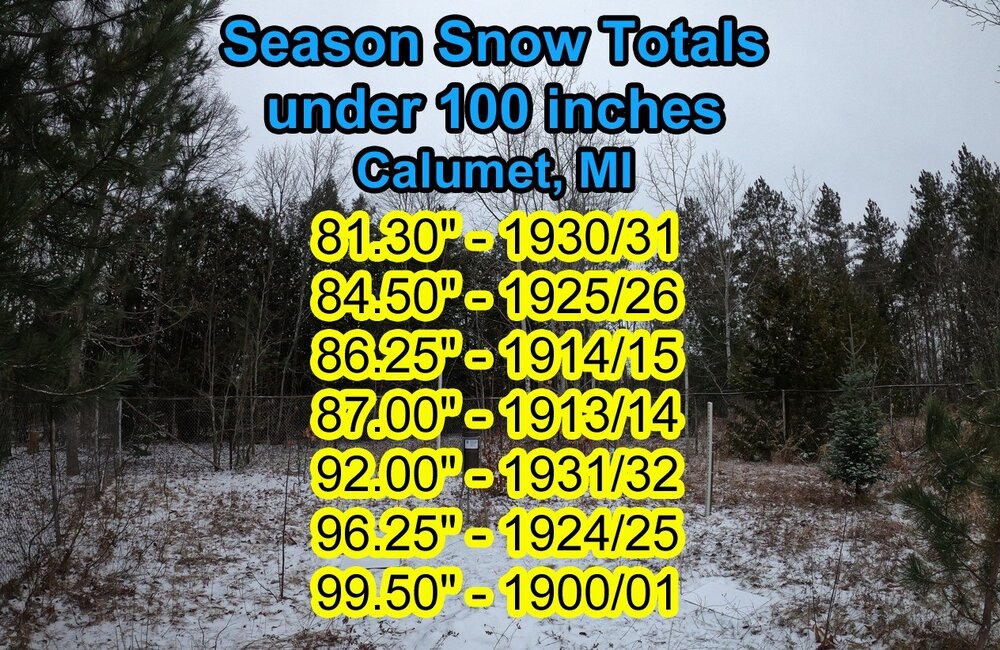
Wow. The early 20th century sure had a lot of low snow winters. Calumet is already over 100 inches this winter and it’s only mid Feb. I can’t even imagine how snowless those winters felt at the time.
-
1
-
-
5 minutes ago, Lightning said:
Did you have a t-storm year last year? After the dry June it changed a became active here as we were generally on the edge of the heat dome last year. Yes I do recall 1995

We had quite a few t-storms last summer but it was never really “hot” to the south. If it’s 100F with a dew point of 75F in Chicago and “cool” in central Ontario, that’s when we get the good nocturnal stuff. T-storms developing in northern Minnesota/Wisconsin in the late afternoon means watch out here that night.
-
1
-
-
We need the heat dome to be strong to the south so we can get some interesting weather here during the summer. Being on the edge of the heat is the place to be during the summer. 1995 comes to mind.
-
1
-


Occasional Thoughts on Climate Change
in Climate Change
Posted
So we will combat human induced climate change with human induced climate change? Sounds about right.