canderson
-
Posts
23,919 -
Joined
-
Last visited
Content Type
Profiles
Blogs
Forums
American Weather
Media Demo
Store
Gallery
Everything posted by canderson
-
Central PA - Winter 2021/2022
canderson replied to Bubbler86's topic in Upstate New York/Pennsylvania
Much better day that I expect. Dry, 50, sunny for a good bit. Had some wind in a nearby rain storm but was dry here. Had returns overhead twice but nothing reached the ground. -
Central PA - Winter 2021/2022
canderson replied to Bubbler86's topic in Upstate New York/Pennsylvania
Still no rain unless I missed a sprinkle. 50 and sunny - not bad at all out. -
Central PA - Winter 2021/2022
canderson replied to Bubbler86's topic in Upstate New York/Pennsylvania
Dry in the city so far - all these little rain areas have mixed me thus far. But it’s dark now and rain immediately to my west so we might get some moisture here soon. -
Central PA - Winter 2021/2022
canderson replied to Bubbler86's topic in Upstate New York/Pennsylvania
Smarch sounds like something the wife says you're never allowed to do after the first Valentine's Day as a married couple. -
Central PA - Winter 2021/2022
canderson replied to Bubbler86's topic in Upstate New York/Pennsylvania
Visual representation! I fee like @Voyager -
Central PA - Winter 2021/2022
canderson replied to Bubbler86's topic in Upstate New York/Pennsylvania
It just went POOF. It was wild. -
Central PA - Winter 2021/2022
canderson replied to Bubbler86's topic in Upstate New York/Pennsylvania
That huge line of heavy rain and storms out west got absolutely demolished by the mountains. Wow. Heavy rain in Juanita County and HBG won’t see more than a trace. -
Central PA - Winter 2021/2022
canderson replied to Bubbler86's topic in Upstate New York/Pennsylvania
Got some yard stakes I can put around to hold it up I think. They’re pretty close to the house too so that’ll help with warmth. -
Central PA - Winter 2021/2022
canderson replied to Bubbler86's topic in Upstate New York/Pennsylvania
Good idea. I might put some burlap down - would be easier (we have a lot of them on the long side garden). -
Central PA - Winter 2021/2022
canderson replied to Bubbler86's topic in Upstate New York/Pennsylvania
My blooming hyacinth are gonna get toasted boooooo -
Central PA - Winter 2021/2022
canderson replied to Bubbler86's topic in Upstate New York/Pennsylvania
Sun will pop soon but it's raw for sure. -
Central PA - Winter 2021/2022
canderson replied to Bubbler86's topic in Upstate New York/Pennsylvania
The rain has been strange. A ton of very small pockets of rain in no order or pattern just marching east. -
Central PA - Winter 2021/2022
canderson replied to Bubbler86's topic in Upstate New York/Pennsylvania
I’m very liberal indeed but arguing politics on a messageboard is almost as dumb as watering the yard during a hurricane. -
Central PA - Winter 2021/2022
canderson replied to Bubbler86's topic in Upstate New York/Pennsylvania
I didn’t even know there was an OT forum here. I poked in and one I the top threads is “the Brandon administration” so I immediately left and threw my phone into the river. -
Central PA - Winter 2021/2022
canderson replied to Bubbler86's topic in Upstate New York/Pennsylvania
Thought it was going to rain all day? It's sunny and forecast has nothing until tonight. -
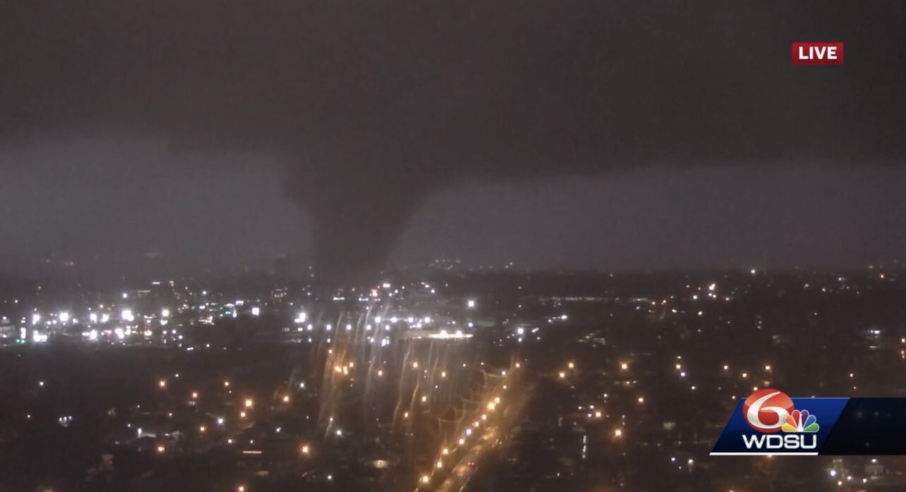
Got pretty lucky it recycled around Slidell. Big pop center around there was in the path. But I think come daybreak we get wild images from the 9th ward.
-
Tornado on the ground in NOLA - skycam has images.
-
Central PA - Winter 2021/2022
canderson replied to Bubbler86's topic in Upstate New York/Pennsylvania
54 and thick clouds here too. -
Central PA - Winter 2021/2022
canderson replied to Bubbler86's topic in Upstate New York/Pennsylvania
FWIW the Trader Joe's in Camp Hill opens March 31. Rejoice! -
1.5” inch hail for my parents. No tornado.
-
Worst of that northern line working near Tyler appears it’ll move about 5-10 miles NW of my parents. South of that line - Crockett is in serious danger of a stovepipe cited by Timmer.