

canderson
-
Posts
25,280 -
Joined
-
Last visited
Content Type
Profiles
Blogs
Forums
American Weather
Media Demo
Store
Gallery
Everything posted by canderson
-
Central PA Winter 2022/2023
canderson replied to Blizzard of 93's topic in Upstate New York/Pennsylvania
Friday will be windy af around these parts. -
Central PA Winter 2022/2023
canderson replied to Blizzard of 93's topic in Upstate New York/Pennsylvania
It's pouring rain. This blows. -
Central PA Winter 2022/2023
canderson replied to Blizzard of 93's topic in Upstate New York/Pennsylvania
I have to agree; abnormalities out west mean abnormalities here in the east. Of course I believe these abnormalities are no longer abnormal and a significant climate adjustment. -
Central PA Winter 2022/2023
canderson replied to Blizzard of 93's topic in Upstate New York/Pennsylvania
Yeah, I just don't see that happening in time for the next two storm opportunities. Think we have to wait until the turn of the month, but I'm an idiot who is skeptical of snow when the winter has been non-existant for like 92 percent of the US' population. -
Central PA Winter 2022/2023
canderson replied to Blizzard of 93's topic in Upstate New York/Pennsylvania
I'm pretty convinced it won't snow for the LSV at all in any of these threats. The MA/East Coast needs a significant pattern change. -
Central PA Winter 2022/2023
canderson replied to Blizzard of 93's topic in Upstate New York/Pennsylvania
You have pliers and a flashlight. I don’t see a problem*. * jk hope everything’s okay -
Central PA Winter 2022/2023
canderson replied to Blizzard of 93's topic in Upstate New York/Pennsylvania
I have no plans to be traveling this Sunday so let it snow. -
Central PA Winter 2022/2023
canderson replied to Blizzard of 93's topic in Upstate New York/Pennsylvania
Part of my job - it’s fun. -
Central PA Winter 2022/2023
canderson replied to Blizzard of 93's topic in Upstate New York/Pennsylvania
Was raw at the inauguration today. If I don’t catch a cold I’ll be shocked. -
Central PA Winter 2022/2023
canderson replied to Blizzard of 93's topic in Upstate New York/Pennsylvania
Another real nice April day this January. Beautiful clear blue skies and 52. -
Central PA Winter 2022/2023
canderson replied to Blizzard of 93's topic in Upstate New York/Pennsylvania
I watched some of that train video on the train. A bunch of kids were shoveling snow near the track and a freight train came by and blew even more over where they had shoveled. I laughed. -
Central PA Winter 2022/2023
canderson replied to Blizzard of 93's topic in Upstate New York/Pennsylvania
Tomorrow is Martin Luther King Jr Day so probably a holiday. It is for us. -
Central PA Winter 2022/2023
canderson replied to Blizzard of 93's topic in Upstate New York/Pennsylvania
It calmed down here last night thankfully. -
Central PA Winter 2022/2023
canderson replied to Blizzard of 93's topic in Upstate New York/Pennsylvania
My credit card company’s spaceship coming to check on me after I get the bill. -
Central PA Winter 2022/2023
canderson replied to Blizzard of 93's topic in Upstate New York/Pennsylvania
Sun should finally come out here today. -
Central PA Winter 2022/2023
canderson replied to Blizzard of 93's topic in Upstate New York/Pennsylvania
Snowing here in Manhattan. A bit heavier than flurries -
Central PA Winter 2022/2023
canderson replied to Blizzard of 93's topic in Upstate New York/Pennsylvania
My hat blew off here last night! -
Central PA Winter 2022/2023
canderson replied to Blizzard of 93's topic in Upstate New York/Pennsylvania
Ha -thankfully our home decor is pretty minimalist! -
Central PA Winter 2022/2023
canderson replied to Blizzard of 93's topic in Upstate New York/Pennsylvania
Cloudy and 52 here at Columbus Circle overlooking Central Park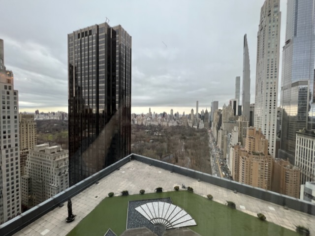
-
Central PA Winter 2022/2023
canderson replied to Blizzard of 93's topic in Upstate New York/Pennsylvania
Indeed! Theater weekend. &Juliet tonight. -
Central PA Winter 2022/2023
canderson replied to Blizzard of 93's topic in Upstate New York/Pennsylvania
On the train - thick clouds in Harrisburg, now in Lancaster and it’s mostly cloudy but the sun is currently shining. -
Central PA Winter 2022/2023
canderson replied to Blizzard of 93's topic in Upstate New York/Pennsylvania
NW. I got .2”. Blizz had .13” more and is bit far way. -
Central PA Winter 2022/2023
canderson replied to Blizzard of 93's topic in Upstate New York/Pennsylvania
Huge lightning bolt sounded as if it hit something somewhat nearby. Deep, deep thunder. Totally normal. -
Central PA Winter 2022/2023
canderson replied to Blizzard of 93's topic in Upstate New York/Pennsylvania
Geez Roger Smith in the NYC forum punted all of January and said not a chance until Feb 4-5. And that is likely very short before another warmup. That’s bad. NYC night set the record for most consecutive days without snowfall in Central Park. -
Central PA Winter 2022/2023
canderson replied to Blizzard of 93's topic in Upstate New York/Pennsylvania
This “storm” Thursday looks weaker and weaker. Won’t be surprised if a lot get less than .25” rain. At least it wasn’t snow and a heartbreaker.


