

cheese007
-
Posts
1,637 -
Joined
-
Last visited
Content Type
Profiles
Blogs
Forums
American Weather
Media Demo
Store
Gallery
Everything posted by cheese007
-
Decided to make a second thread in here since Arkansas makes up the bulk of the highest threat area atm. 30% D6
-
Shaping up to be a busy Friday
-
D2 MOD issued covering much of Arkansas
-
Sizeable 15% D7 out for next Tuesday
-
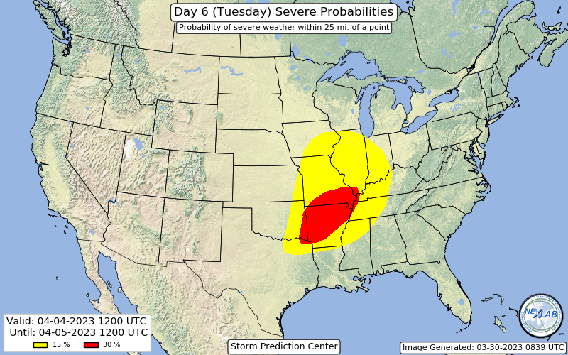
3-30 risk area shrunk down but 3-31 expanded dramatically with a 30% contour added
-
Severe Weather 3-23-23 through 3-26-23
cheese007 replied to cheese007's topic in Central/Western States
You would need a tornado of that strength to hit the center of a major metro area because that's pretty much the only place you'd find good enough construction. And I mean like the center-center not the suburbs (which have houses of questionable build quality 95% of the time) -
Severe Weather 3-23-23 through 3-26-23
cheese007 replied to cheese007's topic in Central/Western States
Now 23 -
Severe Weather 3-23-23 through 3-26-23
cheese007 replied to cheese007's topic in Central/Western States
-
D7 15% issued covering large, populated chunks of KS/OK/TX. Something to watch
-
Severe Weather 3-23-23 through 3-26-23
cheese007 replied to cheese007's topic in Central/Western States
Tornado Emergency now issued -
Severe Weather 3-23-23 through 3-26-23
cheese007 replied to cheese007's topic in Central/Western States
Oh my God I did not expect to see this thing was still going after not checking this thread for over an hour. Nightmare scenario -
Severe Weather 3-23-23 through 3-26-23
cheese007 replied to cheese007's topic in Central/Western States
Yikes @ Memphis being in the Mod risk area -
Got 15% contours on D4/D5 covering parts of OK and TX the first day and AR/AL/LA/MS/TX/TN the second
-
great shot on wfaa now
-
Tor warning for Dallas. Close to October 20, 2019 path
-
NWS confirmed tor
-
wall cloud on Michael Beard's stream on livestormchasing
-
Tor warning for Tarrant county
-
Tennis ball size hail on that Mineral Wells storm. On track to go right over both Fort Worth and Dallas downtown
-
Tor watch out until 8, 50-20 Tor Probs, 60-20 wind, and 60-60 hail https://www.spc.noaa.gov/products/watch/ww0068.html
-
10% tor probs added in latest outlook
-
SPC put out a 15% contour for Day 4/Thursday focused on the Ark/La/Tex and Texoma into DFW, OKC, and Tulsa metros
-
March 3 High Wind and Severe potential
cheese007 replied to Holston_River_Rambler's topic in Tennessee Valley
70/50 tor probs on both the newsest watches -
March 2nd Moderate Risk ArkLaTex
cheese007 replied to Ed, snow and hurricane fan's topic in Central/Western States
https://www.facebook.com/161908093830061/posts/pfbid02mZtohEnzMmRDBY5CkydLDeaYQKXRkcHPDkyew234S3vUh4PUxXbFCTrhdG2jroK2l/?sfnsn=mo&mibextid=ijjfgs -
March 2nd Moderate Risk ArkLaTex
cheese007 replied to Ed, snow and hurricane fan's topic in Central/Western States
Lost power where we're at before the storms even showed up


