

cheese007
-
Posts
1,616 -
Joined
-
Last visited
Content Type
Profiles
Blogs
Forums
American Weather
Media Demo
Store
Gallery
Posts posted by cheese007
-
-
Mesoscale Discussion 0421
   NWS Storm Prediction Center Norman OK
   1023 PM CDT Fri Mar 31 2023

   Areas affected...northern Mississippi

   Concerning...Tornado Watch 97...99...

   Valid 010323Z - 010530Z

   The severe weather threat for Tornado Watch 97, 99 continues.

   SUMMARY...Severe risk continues. Tornado environment is becoming
   more favorable across northern Mississippi.

   DISCUSSION...A broken line of storms moving across the
   Arkansas/Mississippi border is tracking eastward into an environment
   becoming favorable for strong tornadoes. VAD profiles from DGX
   (Brandon, MS) and GWX (Columbus Air Force Base) show low-level shear
   has increased to around 400-700 m2/s2 as the nocturnal low-level jet
   has strengthened. Surface objective analysis indicates SBCAPE around
   1000-1500 J/kg ahead of the advancing line of storms. Expect the
   storms moving in from the west to organize with increasing threat of
   strong tornadoes over the next few hours.

   ..Thornton/Edwards.. 04/01/2023

   ...Please see www.spc.noaa.gov for graphic product...

   ATTN...WFO...MEG...JAN...LZK...

   LAT...LON   33879128 34389079 34879013 35008961 34978912 34958876
               34798849 34428840 34188847 34018860 33788872 33548894
               33408922 33308955 33318984 33349025 33359060 33499103
               33579118 33879128
.png.2bfa324538e03fa7e00278d0c1a915bf.png)
-
Possible circulation heading into downtown Kokomo per WTHR 13: https://www.wthr.com/article/weather/weather-blog/live-coverage-tornado-warnings-for-greene-white-several-other-counties/531-c7db4b59-8e21-4717-9744-8566479a5824
-
Possible circulation heading into downtown Kokomo per WTHR 13: https://www.wthr.com/article/weather/weather-blog/live-coverage-tornado-warnings-for-greene-white-several-other-counties/531-c7db4b59-8e21-4717-9744-8566479a5824
-
 1
1
-
-
Just now, Jackstraw said:
That SW IN cell is getting ready to move into some decently populated areas like Martinsville. Cookie cutter subdivisions from hell around there
Yeah it looks like it's about to ride the highway

-
Tor warning near Alamo KY. These storms are really going nuts. Just popping up and dropping tors with little warning
-
 1
1
-
-
3 minutes ago, cheese007 said:
New tor warning between Colfax and Thorntown IN
Debris ball
-
New tor warning between Colfax and Thorntown IN
-
Tor emergency for the newer Tunica cell
-
Just now, kayman said:
TOG near Tunica, MS
Brett Adair had it on stream for a bit
-
8 minutes ago, weatherextreme said:
Impressive catching that rain wrapped beast!
-
8 minutes ago, weatherextreme said:
Matt Grantham is on the same storm (Brandon's stream cut out)
-
Major damage on Brian Emfinger's stream out of Little Rock
-
Major damage on Brian Emfinger's stream
-
Any streams out of Peoria?
-
Big TOG in Little Rock. Tor emergency issues
-
BIG TOG in Little Rock. Tor emegrency
-
-
TOG on Brett Adair's stream near Little Rock
-
Looks like TOG
-
And now AR
Tornado Warning
Tornado Warning ARC019-051-059-097-105-109-311815- /O.NEW.KLZK.TO.W.0035.230331T1741Z-230331T1815Z/ BULLETIN - EAS ACTIVATION REQUESTED Tornado Warning National Weather Service Little Rock AR 1241 PM CDT Fri Mar 31 2023 The National Weather Service in Little Rock has issued a * Tornado Warning for... Northwestern Clark County in southwestern Arkansas... Southwestern Perry County in central Arkansas... Northwestern Pike County in southwestern Arkansas... Garland County in central Arkansas... Southeastern Montgomery County in western Arkansas... West central Hot Spring County in southwestern Arkansas... * Until 115 PM CDT. * At 1240 PM CDT, a severe thunderstorm capable of producing a tornado was located near Daisy, or 13 miles east of Umpire, moving northeast at 60 mph. HAZARD...Tornado and half dollar size hail. SOURCE...Radar indicated rotation. IMPACT...Flying debris will be dangerous to those caught without shelter. Mobile homes will be damaged or destroyed. Damage to roofs, windows, and vehicles will occur. Tree damage is likely. * Locations impacted include... Hot Springs... Glenwood... Mountain Pine... Norman... Daisy... Hot Springs Memorial Field... Meyers... Lake Ouachita State Park... Lofton... Rockwell... Hot Springs National Park... Daisy State Park... Avant... Oaklawn Racetrack... Bonnerdale... Mt Tabor... Sunshine... Lodi... Langley... Royal... PRECAUTIONARY/PREPAREDNESS ACTIONS... TAKE COVER NOW! Move to a basement or an interior room on the lowest floor of a sturdy building. Avoid windows. If you are outdoors, in a mobile home, or in a vehicle, move to the closest substantial shelter and protect yourself from flying debris. && LAT...LON 3420 9387 3429 9391 3483 9318 3445 9296 TIME...MOT...LOC 1740Z 238DEG 52KT 3429 9381 TORNADO...RADAR INDICATED MAX HAIL SIZE...1.25 IN $$ 53 -
It begins
Tornado Warning IAC039-053-159-175-311830- /O.NEW.KDMX.TO.W.0001.230331T1740Z-230331T1830Z/ BULLETIN - EAS ACTIVATION REQUESTED Tornado Warning National Weather Service Des Moines IA 1240 PM CDT Fri Mar 31 2023 The National Weather Service in Des Moines has issued a * Tornado Warning for... Northern Decatur County in south central Iowa... Southeastern Union County in south central Iowa... Eastern Ringgold County in south central Iowa... Southwestern Clarke County in south central Iowa... * Until 130 PM CDT. * At 1240 PM CDT, a severe thunderstorm capable of producing a tornado was located 5 miles northwest of Hatfield, or 8 miles south of Mount Ayr, moving northeast at 50 mph. HAZARD...Tornado and golf ball size hail. SOURCE...Radar indicated rotation. IMPACT...Flying debris will be dangerous to those caught without shelter. Mobile homes will be damaged or destroyed. Damage to roofs, windows, and vehicles will occur. Tree damage is likely. * This dangerous storm will be near... Mt Ayr Municipal Airport around 1245 PM CDT. Kellerton around 1255 PM CDT. Beaconsfield around 100 PM CDT. Other locations in the path of this tornadic thunderstorm include Sun Valley Lake, Grand River, Decatur City and Van Wert. This includes Interstate 35 between mile markers 12 and 25. PRECAUTIONARY/PREPAREDNESS ACTIONS... TAKE COVER NOW! Move to a basement or an interior room on the lowest floor of a sturdy building. Avoid windows. If you are outdoors, in a mobile home, or in a vehicle, move to the closest substantial shelter and protect yourself from flying debris. && LAT...LON 4100 9393 4081 9365 4057 9411 4057 9436 TIME...MOT...LOC 1740Z 223DEG 42KT 4059 9420 TORNADO...RADAR INDICATED MAX HAIL SIZE...1.75 IN $$ Hagenhoff -
90/90 tor probs

SEL4

   URGENT - IMMEDIATE BROADCAST REQUESTED
   Tornado Watch Number 94
   NWS Storm Prediction Center Norman OK
   1230 PM CDT Fri Mar 31 2023

   The NWS Storm Prediction Center has issued a

   * Tornado Watch for portions of
     Much of Arkansas
     Southern Illinois
     Western Kentucky
     Southern Missouri
     Northwest Mississippi
     West Tennessee
     Northeast Texas

   * Effective this Friday afternoon and evening from 1230 PM until
     800 PM CDT.

   ...THIS IS A PARTICULARLY DANGEROUS SITUATION...

   * Primary threats include...
     Several tornadoes and a few intense tornadoes likely
     Scattered large hail and isolated very large hail events to 2.5
       inches in diameter likely
     Scattered damaging wind gusts to 70 mph likely

   SUMMARY...Numerous severe thunderstorms are expected to develop and
   spread across the mid Mississippi Valley region this afternoon and
   early evening.  Supercells capable of damaging tornadoes, large
   hail, and damaging winds are all possible.  Parameters are
   sufficiently favorable for the risk of strong/violent tornadoes.

   The tornado watch area is approximately along and 120 statute miles
   east and west of a line from 30 miles east southeast of El Dorado AR
   to 5 miles northwest of Saint Louis MO. For a complete depiction of
   the watch see the associated watch outline update (WOUS64 KWNS
   WOU4).

   PRECAUTIONARY/PREPAREDNESS ACTIONS...

   REMEMBER...A Tornado Watch means conditions are favorable for
   tornadoes and severe thunderstorms in and close to the watch
   area. Persons in these areas should be on the lookout for
   threatening weather conditions and listen for later statements
   and possible warnings.

   &&

   OTHER WATCH INFORMATION...CONTINUE...WW 93...

   AVIATION...Tornadoes and a few severe thunderstorms with hail
   surface and aloft to 2.5 inches. Extreme turbulence and surface wind
   gusts to 60 knots. A few cumulonimbi with maximum tops to 500. Mean
   storm motion vector 25035.

   ...Hart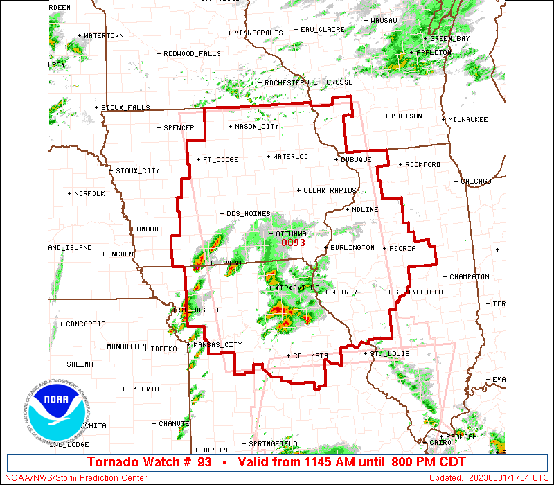
March 31st Severe Threat
in Lakes/Ohio Valley
Posted
Nashville may end up under a tor warning in the coming hour