

cheese007
-
Posts
1,616 -
Joined
-
Last visited
Content Type
Profiles
Blogs
Forums
American Weather
Media Demo
Store
Gallery
Posts posted by cheese007
-
-
95/90 tor probs
SEL3 URGENT - IMMEDIATE BROADCAST REQUESTED Tornado Watch Number 93 NWS Storm Prediction Center Norman OK 1145 AM CDT Fri Mar 31 2023 The NWS Storm Prediction Center has issued a * Tornado Watch for portions of Central and Eastern Iowa Western Illinois Northern and Central Missouri Southwest Wisconsin * Effective this Friday morning and evening from 1145 AM until 800 PM CDT. ...THIS IS A PARTICULARLY DANGEROUS SITUATION... * Primary threats include... Numerous tornadoes expected with a few intense tornadoes likely Widespread large hail and isolated very large hail events to 3 inches in diameter likely Widespread damaging wind gusts to 70 mph likely SUMMARY...Intense supercell thunderstorms are expected to develop this afternoon and spread eastward across the watch area. Tornadoes, large hail, and damaging winds are all possible with this activity. Parameters are favorable for the potential for strong/violent tornadoes and very large hail. The tornado watch area is approximately along and 115 statute miles east and west of a line from 30 miles east of Jefferson City MO to 55 miles east northeast of Mason City IA. For a complete depiction of the watch see the associated watch outline update (WOUS64 KWNS WOU3). PRECAUTIONARY/PREPAREDNESS ACTIONS... REMEMBER...A Tornado Watch means conditions are favorable for tornadoes and severe thunderstorms in and close to the watch area. Persons in these areas should be on the lookout for threatening weather conditions and listen for later statements and possible warnings. && AVIATION...Tornadoes and a few severe thunderstorms with hail surface and aloft to 3 inches. Extreme turbulence and surface wind gusts to 60 knots. A few cumulonimbi with maximum tops to 500. Mean storm motion vector 24040. ...Hart -
12 minutes ago, yoda said:
I think that is the largest hatched area I have ever seen for TOR probs on the new Day 1
14 million people in that hatched zone
-
Hatched tor area now covers the space between the two MOD risk zones. Over 14 million people under the gun
-
1 hour ago, olafminesaw said:
I wish the mods could merge the threads from each sub, so it linked to the same place. Really mostly just applies to severe, but it's super annoying to keep up with two threads at once.
Yeah a crossposting function for these overlapping threats would be nice. Like one thread but it's visible in two subforums
-
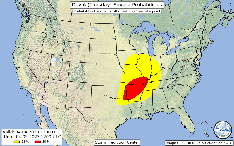
Decided to make a second thread in here since Arkansas makes up the bulk of the highest threat area atm. 30% D6
-
 1
1
-
-
Shaping up to be a busy Friday

-
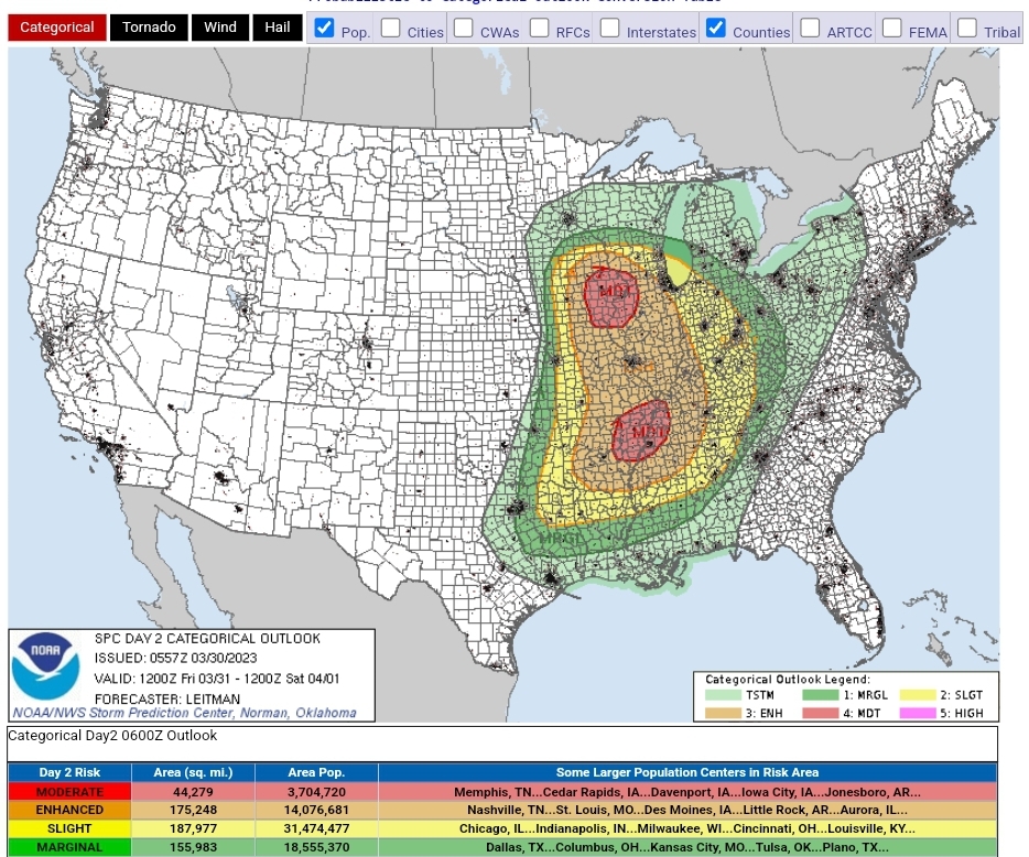
D2 MOD issued covering much of Arkansas

-
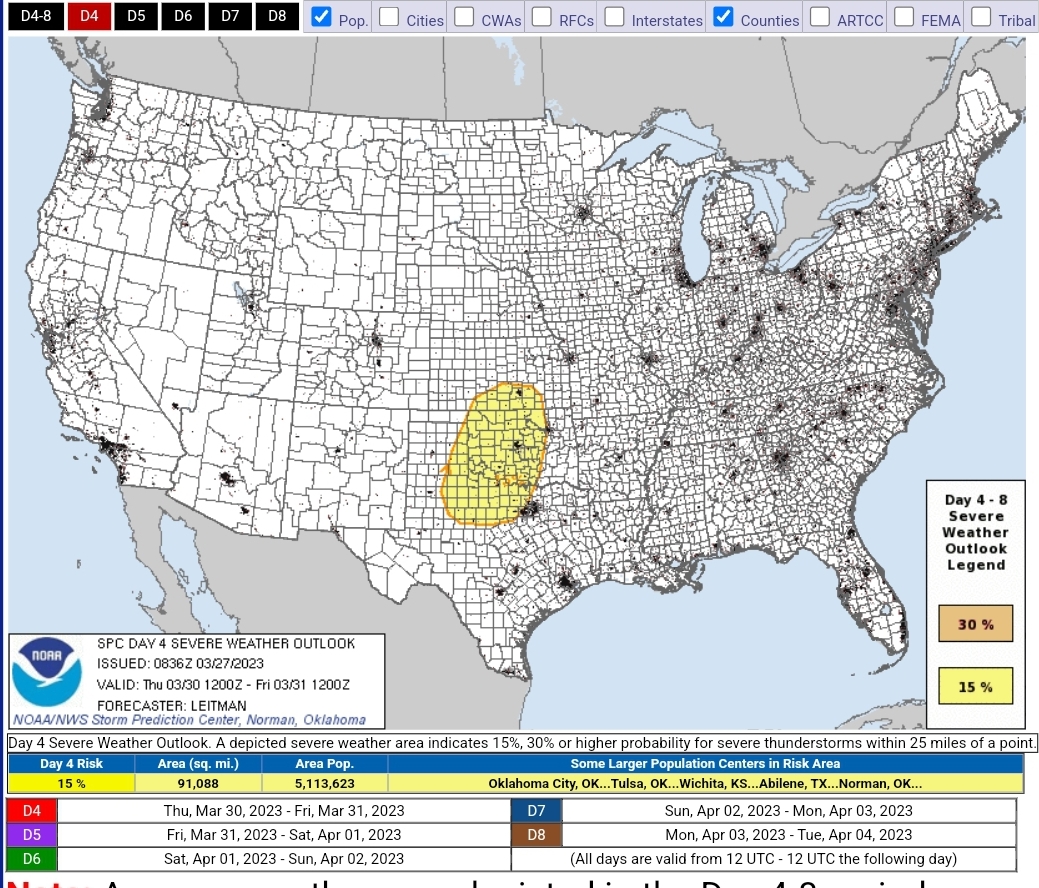
Sizeable 15% D7 out for next Tuesday

-
2
-
-
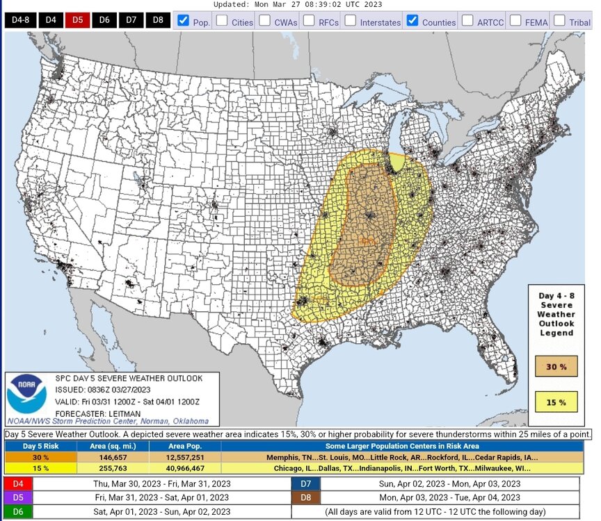
3-30 risk area shrunk down but 3-31 expanded dramatically with a 30% contour added

-
3
-
-
1 hour ago, zinski1990 said:
Feels like an ef5 will never happen again I swear.
You would need a tornado of that strength to hit the center of a major metro area because that's pretty much the only place you'd find good enough construction. And I mean like the center-center not the suburbs (which have houses of questionable build quality 95% of the time)
-
-
-
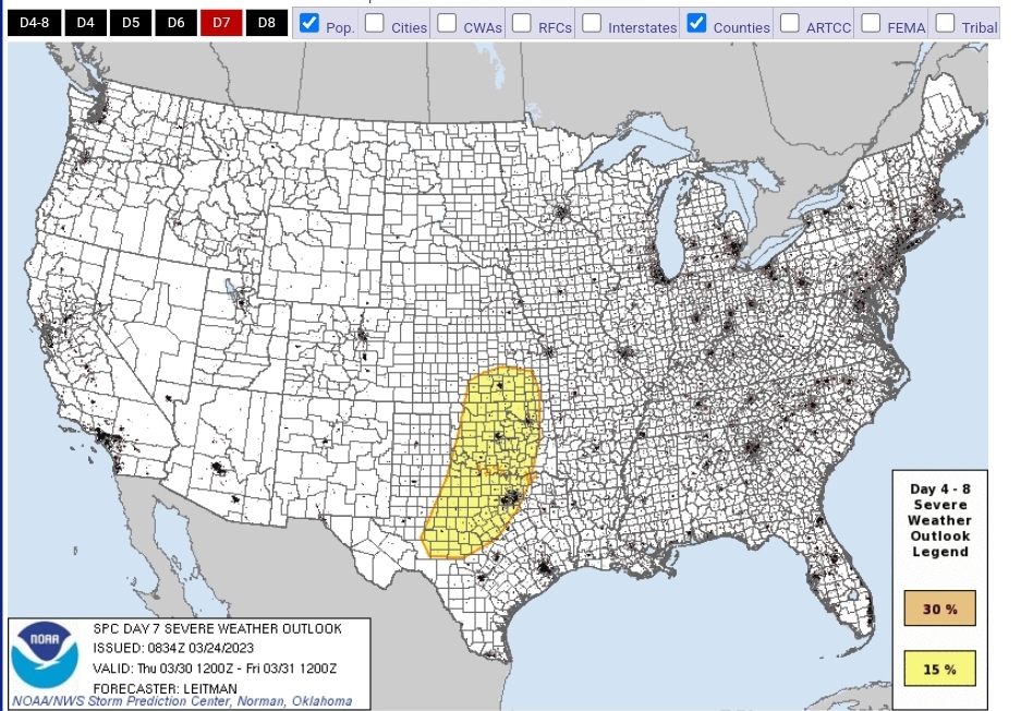
D7 15% issued covering large, populated chunks of KS/OK/TX. Something to watch
-
1
-
 1
1
-
-
Tornado Emergency now issued
-
Oh my God I did not expect to see this thing was still going after not checking this thread for over an hour. Nightmare scenario
-
1
-
-
Yikes @ Memphis being in the Mod risk area
-
Got 15% contours on D4/D5 covering parts of OK and TX the first day and AR/AL/LA/MS/TX/TN the second


-
1
-
 1
1
-
-
great shot on wfaa now
-
1
-
-
Tor warning for Dallas. Close to October 20, 2019 path
-
NWS confirmed tor
-
wall cloud on Michael Beard's stream on livestormchasing
-
Tor warning for Tarrant county
-
1
-
-
Tennis ball size hail on that Mineral Wells storm. On track to go right over both Fort Worth and Dallas downtown
-
Tor watch out until 8, 50-20 Tor Probs, 60-20 wind, and 60-60 hail


Severe Weather 3-30-23 and 3-31-23
in Central/Western States
Posted
90/90 tor probs
SEL4 URGENT - IMMEDIATE BROADCAST REQUESTED Tornado Watch Number 94 NWS Storm Prediction Center Norman OK 1230 PM CDT Fri Mar 31 2023 The NWS Storm Prediction Center has issued a * Tornado Watch for portions of Much of Arkansas Southern Illinois Western Kentucky Southern Missouri Northwest Mississippi West Tennessee Northeast Texas * Effective this Friday afternoon and evening from 1230 PM until 800 PM CDT. ...THIS IS A PARTICULARLY DANGEROUS SITUATION... * Primary threats include... Several tornadoes and a few intense tornadoes likely Scattered large hail and isolated very large hail events to 2.5 inches in diameter likely Scattered damaging wind gusts to 70 mph likely SUMMARY...Numerous severe thunderstorms are expected to develop and spread across the mid Mississippi Valley region this afternoon and early evening. Supercells capable of damaging tornadoes, large hail, and damaging winds are all possible. Parameters are sufficiently favorable for the risk of strong/violent tornadoes. The tornado watch area is approximately along and 120 statute miles east and west of a line from 30 miles east southeast of El Dorado AR to 5 miles northwest of Saint Louis MO. For a complete depiction of the watch see the associated watch outline update (WOUS64 KWNS WOU4). PRECAUTIONARY/PREPAREDNESS ACTIONS... REMEMBER...A Tornado Watch means conditions are favorable for tornadoes and severe thunderstorms in and close to the watch area. Persons in these areas should be on the lookout for threatening weather conditions and listen for later statements and possible warnings. && OTHER WATCH INFORMATION...CONTINUE...WW 93... AVIATION...Tornadoes and a few severe thunderstorms with hail surface and aloft to 2.5 inches. Extreme turbulence and surface wind gusts to 60 knots. A few cumulonimbi with maximum tops to 500. Mean storm motion vector 25035. ...Hart