

cheese007
-
Posts
1,600 -
Joined
-
Last visited
Content Type
Profiles
Blogs
Forums
American Weather
Media Demo
Store
Gallery
Posts posted by cheese007
-
-
7 minutes ago, Powerball said:
Got a line ripping right over the Metroplex.
Not severe thus far, but frequent lightning and loud cracks of thunder.
Yeah it picked up real quick
-
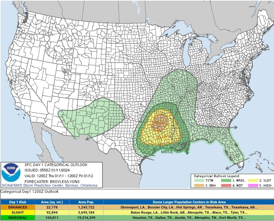
Surprised to see a D1 hatched ENH centered on the ArkLaTex this morning. Then I saw it was Broyles and it made more sense.
 Still worth watching I guess...
SPC AC 110558

   Day 1 Convective Outlook
   NWS Storm Prediction Center Norman OK
   1158 PM CST Wed Jan 10 2024

   Valid 111200Z - 121200Z

   ...THERE IS AN ENHANCED RISK OF SEVERE THUNDERSTORMS ACROSS PARTS OF
   THE ARK-LA-TEX...

   ...SUMMARY...
   Severe thunderstorms, associated with tornadoes, wind damage and
   isolated large hail, are likely to develop across parts of the
   Ark-La-Tex this evening into the overnight. A severe threat is also
   expected to develop further south across parts of east Texas and
   Louisiana.

   ...Ark-La-Tex...
   An impressive upper-level system will translate quickly eastward
   through the Desert Southwest today, reaching the southern Plains
   this evening. Within the base of the trough, a 100 to 120 knot
   mid-level jet will move through west Texas this evening, as the nose
   of the jet overspreads the Ark-La-Tex. Ahead of the system, moisture
   will return northward across east Texas and Louisiana, with the nose
   of the moist sector reaching southern Arkansas by early evening. In
   response, a pocket of instability is forecast to develop across
   southeast Oklahoma, southwest Arkansas and northeast Texas, where
   convective initiation is expected during the mid evening.
   Thunderstorms are likely to rapidly increase in coverage during the
   late evening. Most hi-resolution models develop a line of strong to
   severe storms and move the line slowly eastward across southwest
   Arkansas and far northeast Texas during the early overnight period.
   As lift and shear increase due to the approach the mid-level jet,
   conditions are expected to become favorable for severe storms.

   Model forecast soundings across the Ark-La-Tex by 06Z have surface
   dewpoints near 60 F as far north as the Louisiana and Arkansas state
   line. Even so, MLCAPE should reach the 500 to 1000 J/kg range at the
   northern edge of the moist sector by late evening. Very strong lift
   associated with the exit region of the mid-level jet combined with
   low LCL heights and strong low-level shear should be favorable for
   supercells embedded in the line, and with the more discrete cells
   that develop ahead of the line. Some forecast soundings suggest that
   700-500 mb lapse rates will approach 8 C/km across the northern part
   of the warm sector. Although the large-hail threat should remain
   isolated, the steep mid-level lapse rates should be sufficient for a
   significant-hail threat. Hailstones of greater than 2 inches in
   diameter will be possible a few hours after cells initiation, as the
   storms mature. In addition, 0-3 km storm-relative helicity is
   forecast to peak near 400 m2/s2 in and just north of the Shreveport
   vicinity. This is also expected to support a tornado threat with the
   more intense supercells. Any supercell that can persist and become
   dominant may be able to produce a significant tornado or two. A
   wind-damage threat will also likely develop along the line of
   storms, with the greatest potential located across Ark-La-Tex, where
   an Enhanced risk has been introduced.

   ...East Texas/Louisiana...
   Further south into east Texas and Louisiana, storm coverage is
   expected to be more isolated from the late evening into the
   overnight period. In this area, to the south of the mid-level jet
   axis, instability is not expected to be as strong. Also, lift may
   not be quite as concentrated. For this reason, supercell development
   is expected to remain more isolated. Any cell that can become
   organized and sustained could produce isolated large hail, wind
   damage and a tornado or two. The severe threat should more isolated
   with southward extent, with only a marginal severe threat expected
   near in the coastal sections of southeast Texas and southern
   Louisiana.

   ..Broyles/Lyons.. 01/11/2024

   CLICK TO GET WUUS01 PTSDY1 PRODUCT

   NOTE: THE NEXT DAY 1 OUTLOOK IS SCHEDULED BY 1300Z
   CURRENT UTC TIME: 1111Z (5:11AM), RELOAD THIS PAGE TO UPDATE THE TIME
-
 1
1
-
-
1 hour ago, vwgrrc said:
But the both 12z and 18z suit came in pretty dry for Dallas is it not? It's cold for sure but dry.
Yeah FWD seems... skeptical of any precip for DFW
-
Tornado Warning TXC113-139-050330- /O.NEW.KFWD.TO.W.0066.231005T0242Z-231005T0330Z/ BULLETIN - EAS ACTIVATION REQUESTED Tornado Warning National Weather Service Fort Worth TX 942 PM CDT Wed Oct 4 2023 The National Weather Service in Fort Worth has issued a * Tornado Warning for... Northwestern Ellis County in north central Texas... Southern Dallas County in north central Texas... * Until 1030 PM CDT. * At 942 PM CDT, a severe thunderstorm capable of producing a tornado was located over Midlothian, moving east at 30 mph. HAZARD...Tornado and half dollar size hail. SOURCE...Radar indicated rotation. IMPACT...Flying debris will be dangerous to those caught without shelter. Mobile homes will be damaged or destroyed. Damage to roofs, windows, and vehicles will occur. Tree damage is likely. * This dangerous storm will be near... Cedar Hill and Midlothian around 950 PM CDT. Waxahachie, Ovilla and Oak Leaf around 955 PM CDT. Glenn Heights and Red Oak around 1000 PM CDT. Ennis around 1015 PM CDT. Palmer around 1020 PM CDT. Other locations impacted by this tornadic thunderstorm include Ike, Garrett, Trumbull, Pecan Hill, Boyce, Rockett, India and Joe Pool Lake. This includes the following highways... Interstate 35E between mile markers 399 and 414. Interstate 45 between mile markers 251 and 270. PRECAUTIONARY/PREPAREDNESS ACTIONS... TAKE COVER NOW! Move to an interior room on the lowest floor of a sturdy building. Avoid windows. If you are outdoors, in a mobile home, or in a vehicle, move to the closest substantial shelter and protect yourself from flying debris. Tornadoes are extremely difficult to see and confirm at night. Do not wait to see or hear the tornado. TAKE COVER NOW! && LAT...LON 3232 9661 3242 9709 3243 9709 3251 9708 3255 9704 3258 9704 3261 9656 TIME...MOT...LOC 0242Z 283DEG 25KT 3250 9704 TORNADO...RADAR INDICATED MAX HAIL SIZE...1.25 IN $$ Bonnette -
Beautiful supercell on the TX Storm Chaser YouTube live feed
-
49 minutes ago, nwohweather said:
That cell west of OKC is wild. Moving in a completely different directionGolf ball hail and 60 mph winds on that thing
-
Severe Weather Statement National Weather Service Fort Worth TX 539 PM CDT Tue Sep 19 2023 TXC121-192300- /O.CON.KFWD.SV.W.0511.000000T0000Z-230919T2300Z/ Denton TX- 539 PM CDT Tue Sep 19 2023 ...A SEVERE THUNDERSTORM WARNING REMAINS IN EFFECT UNTIL 600 PM CDT FOR NORTHWESTERN DENTON COUNTY... At 539 PM CDT, a severe thunderstorm was located near Krum, or 9 miles west of Denton, moving southeast at 20 mph. HAZARD...60 mph wind gusts and quarter size hail. SOURCE...Radar indicated. IMPACT...Hail damage to vehicles is expected. Expect wind damage to roofs, siding, and trees. Locations impacted include... Denton, Corinth, Sanger, Krum, Shady Shores, Ponder, Stony, and Bolivar. LAT...LON 3337 9711 3315 9704 3320 9739 3337 9738 TIME...MOT...LOC 2239Z 325DEG 18KT 3323 9729 HAIL THREAT...RADAR INDICATED MAX HAIL SIZE...1.00 IN WIND THREAT...RADAR INDICATED MAX WIND GUST...60 MPH $$ Dunn -
Quite the storms heading through Tarrant county atm
Severe Thunderstorm Warning TXC251-439-090430- /O.NEW.KFWD.SV.W.0496.230909T0353Z-230909T0430Z/ BULLETIN - EAS ACTIVATION REQUESTED Severe Thunderstorm Warning National Weather Service Fort Worth TX 1053 PM CDT Fri Sep 8 2023 The National Weather Service in Fort Worth has issued a * Severe Thunderstorm Warning for... Northeastern Johnson County in north central Texas... South central Tarrant County in north central Texas... * Until 1130 PM CDT. * At 1052 PM CDT, a severe thunderstorm was located over Crowley, moving southeast at 25 mph. THIS IS A DESTRUCTIVE STORM FOR AREAS FROM CROWLEY TO BURLESON IN SOUTHERN TARRANT COUNTY AND NORTHERN JOHNSON COUNTY! HAZARD...80 mph wind gusts. SOURCE...Radar indicated. IMPACT...Flying debris will be dangerous to those caught without shelter. Mobile homes will be heavily damaged. Expect considerable damage to roofs, windows, and vehicles. Extensive tree damage and power outages are likely. * Locations impacted include... Fort Worth, Burleson, Crowley, Everman, Keene, Joshua, Alvarado, Rendon, Edgecliff Village, Cross Timber, Edgecliff, Briaroaks, Egan, and Lillian. This includes Interstate 35W between mile markers 29 and 44. PRECAUTIONARY/PREPAREDNESS ACTIONS... For your protection get inside a sturdy structure and stay away from windows. && LAT...LON 3257 9745 3267 9734 3249 9715 3240 9730 TIME...MOT...LOC 0352Z 325DEG 21KT 3259 9735 THUNDERSTORM DAMAGE THREAT...DESTRUCTIVE HAIL THREAT...RADAR INDICATED MAX HAIL SIZE...<.75 IN WIND THREAT...RADAR INDICATED MAX WIND GUST...80 MPH $$-
 2
2
-
-
When was the last time a tropical cyclone made landfall in CA?
-
1
-
-
Finally getting a sub-100 degree high in the forecast for DFW. Tuesday the 15th
-
1
-
-
https://www.earthcam.com/usa/pennsylvania/philadelphia/?cam=philly wind starting to pick up
-
 1
1
-
-
Bryce Shelton has a pretty good view of the Hagerstown cell
-
1
-
-
Huge expansion of the ENH with the latest update
-
Oh and here is my album from today's storm chase! That storm tried hard (and has been trying still) to put down a tornado. Lots of spin
-
1
-
-
Gotta say I'm a little confused as to why most of northern Dallas county is under a severe tstorm warning, at least from the radar
-
Got some shots of the OK mega-cell's tornado-warned southern portion. Will need to upload when home but man was it pretty!
-
3
-
-
Heading in the direction of Wichita Falls. Depending on how things shake out may end up doubling back to DFW if the "tail end charlie" ends up down here
-
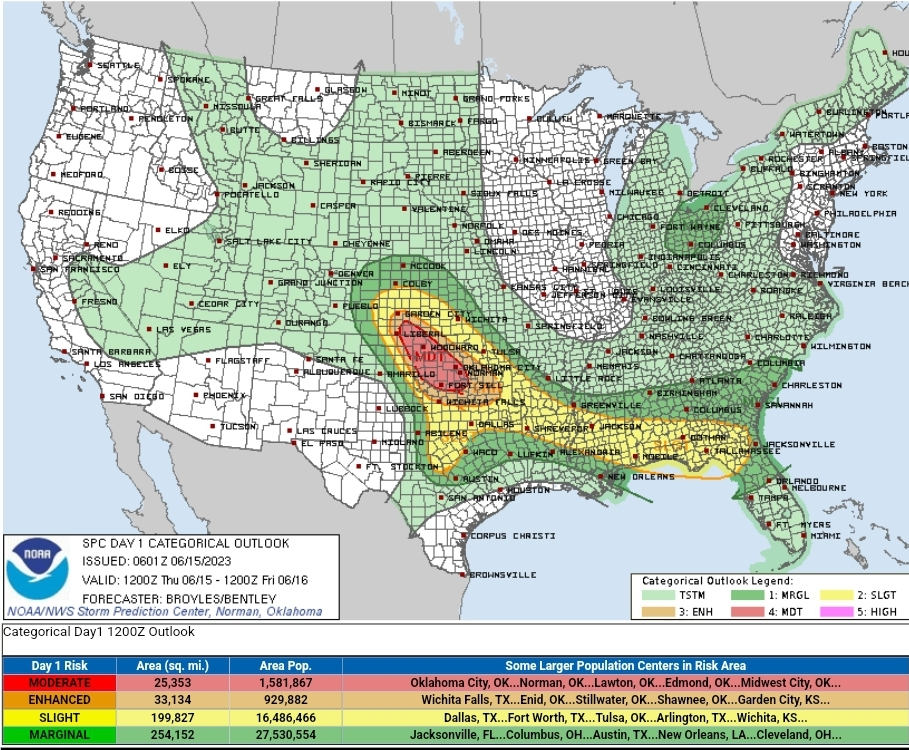
D1 Mod risk is a big jump in one go (though with the caveat it is Broyles)
Forecast Discussion SPC AC 150601 Day 1 Convective Outlook NWS Storm Prediction Center Norman OK 0101 AM CDT Thu Jun 15 2023 Valid 151200Z - 161200Z ...THERE IS A MODERATE RISK OF SEVERE THUNDERSTORMS ACROSS PARTS OF SOUTHWEST KANSAS...WESTERN OKLAHOMA AND THE FAR NORTHEAST TEXAS PANHANDLE... ...THERE IS A SLIGHT RISK OF SEVERE THUNDERSTORMS ACROSS PARTS OF THE SOUTHERN PLAINS AND GULF COAST REGION... ...SUMMARY... Widespread severe storms associated with damaging wind gusts, large hail and a few tornadoes are expected today across parts of the southern and central Plains. Hailstones greater than 2 inches in diameter and wind gusts above 70 knots will be likely along the more intense parts of a fast-moving line of storms. A severe threat is also expected to develop in parts of the Southeast, and in parts of the Ohio Valley. ...Significant Severe Weather Event Expected Today Across Parts of the Southern and Central Plains... ...Southern and Central Plains... A shortwave trough will move into the central U.S. today, as an associated 80 to 95 knot upper-level jet moves into the southern Plains. Ahead of the jet max, a moist and very unstable airmass will be in place from parts of central and north Texas into western Oklahoma and the eastern Texas Panhandle. At the surface, a low will deepen across the southern High Plains as a cold front moves southward through the central High Plains. Ahead of the front, surface heating and increasing low-level convergence will likely result in convective initiation early this afternoon. Storms will rapidly increase in coverage along an axis of strong instability from southwest Kansas south-southeastward across the far northeastern Texas Panhandle and into western Oklahoma. As storms grow upscale, MCS development is expected to occur late this afternoon and be maintained through the evening. By midday, a narrow corridor of maximized low-level moisture is forecast from northwest Texas extending north-northwestward into southwest Kansas. MLCAPE is forecast to reach the 3000 to 4500 J/Kg range by mid afternoon. In addition, RAP forecast soundings have low to mid-level lapse rates approaching 9.0 C/km. This potent thermodynamic environment will be augmented by an increase of deep-layer shear throughout the day, as an upper-level jet moves in from the west-southwest. Upon approach, an increase in large-scale ascent will be coupled with strengthening deep-layer shear. RAP forecast soundings suggest that 0-6 km shear could reach 60 to 70 knots along the instability axis, which will be very favorable for severe storms. The current thinking is that cells will first initiate in the early afternoon, with supercells forming rather quickly. A small cluster is expected to rapidly expand during the mid afternoon, as a line of supercells develops. Hailstones of greater than 2 inches in diameter, along with a tornado threat will be possible with the more intense supercells. As the convective cluster grows upscale in the mid to late afternoon, a Derecho will become possible as an organized severe line segment moves southeastward across the southern Plains. Wind gusts ahead of the more intense parts of the line will likely be greater than 70 knots. A few tornadoes will be possible, along with a continued threat for large hail from late afternoon into the evening. The MCS, associated with a potential for damaging wind gusts, could move into the Ark-La-Tex by mid to late evening, and into parts of the lower Mississippi Valley during the overnight period. ...Southeast... A shortwave trough will move through the central Gulf Coast states today, as a cold front advances southward across toward the central and eastern Gulf Coast. Ahead of the front, surface dewpoints in the lower to mid 70s F, will contribute to strong destabilization by afternoon. MLCAPE is forecast to peak in the 2000 to 3000 J/kg range by afternoon. Thunderstorms are expected to form ahead of the front, and will likely be concentrated along pre-existing outflow boundaries. The greatest coverage could occur from far southern Alabama extending eastward into northern Florida, where strong deep-layer shear is forecast to be strong and low-level lapse rates are forecast to be steep. This should lead to a wind-damage threat in the late morning and early afternoon, as storms gradually intensify. An isolated tornado threat and potential for large hail will also likely exist with the stronger cells. The severe threat should move toward the immediate coastal areas during the afternoon as the cold front advances southward. Further northeast into southeast Georgia and southern South Carolina, moderate instability is forecast to develop by midday. A vorticity maximum is expected to move eastward across southern South Carolina around midday, which should support scattered convective development. Thunderstorms that form within the stronger instability could be associated with isolated damaging wind gusts and hail. ...Ohio... An upper-level trough will move southeastward today across the Great Lakes region, as a cold front advances southeastward into Indiana and Ohio. Ahead of the front, surface dewpoints are forecast to be in the lower 60s F. As surface temperatures warm along the moist axis during the day, a pocket of moderate instability is forecast by early afternoon. Thunderstorms will likely form along and ahead of the front, moving southeastward into the Ohio Valley. RAP forecast soundings near this maximum in instability have MLCAPE peaking in the 1500 to 2000 J/kg range, with 0-3 km lapse rates exceeding 8.0 C/Km. This should be enough for a marginal wind-damage threat with the more intense line segments. A threat for hail will also be possible. ..Broyles/Bentley.. 06/15/2023
-
2
-
-
1 hour ago, cstrunk said:
It seems that two have so far. Both severe warned. Ping pongs and quarters.
Now up to baseball and half dollars
-
1 hour ago, Powerball said:
Interestingly enough, although we've been sleeping on it, tomorrow is looking even more ominous for all of North Texas and Southern Oklahoma (including better tornadon potential), although capping might be a bit stronger and the flow (albeit still impressive) is a bit weaker
What might be a good target area?
-
Reed getting the goods
-
Looks like today was a dud for much of NTX
-
Looks like another south of the metro special up for today
-
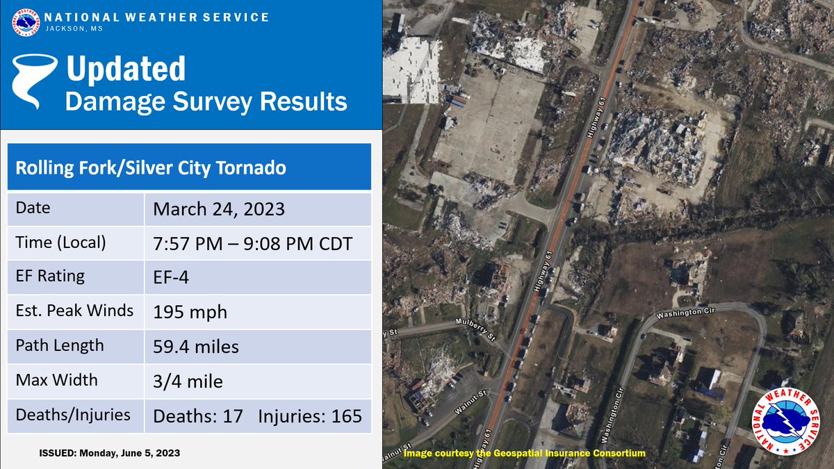
On 6/6/2023 at 8:31 PM, crossbowftw3 said:
Rolling Fork upped to 195 EF4:

Have there been any EF4s rated above 195 since the last EF5?
Texas 2024 Discussion/Observations
in Central/Western States
Posted
Getting a nice dusting near DFW airport