

cheese007
-
Posts
1,600 -
Joined
-
Last visited
Content Type
Profiles
Blogs
Forums
American Weather
Media Demo
Store
Gallery
Posts posted by cheese007
-
-
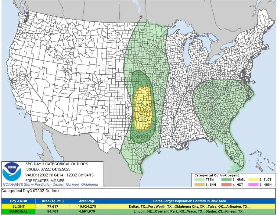
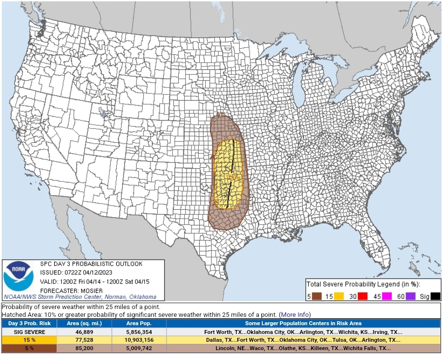
After a bit of a lull on the severe front we have a couple 15% contours out for Friday/Saturday. Friday in particular looks interesting due to th mention of all modes severe and the sig severe contour
t Discussion
SPC AC 120722
Day 3 Convective Outlook
NWS Storm Prediction Center Norman OK
0222 AM CDT Wed Apr 12 2023
Valid 141200Z - 151200Z
...THERE IS A SLIGHT RISK OF SEVERE THUNDERSTORMS OVER PORTIONS OF
EASTERN KANSAS...CENTRAL/EASTERN OKLAHOMA...AND NORTH TEXAS...
...SUMMARY...
Severe thunderstorms capable of all severe hazards, including very
large hail, are possible over portions of eastern Kansas,
central/eastern Oklahoma, and north Texas on Friday.
...Portions of the Southern and Central Plains...
Broad upper troughing over the western CONUS will continue to
gradually move eastward on Friday. A shortwave trough embedded
within this larger upper trough is expected to eject into KS/NE
during the afternoon, continuing northeastward through the Mid MO
Valley during evening.
At the surface, a low initially over the western KS/NE border
vicinity will likely develop southward/southwestward. A dryline will
extend southward from this low across central KS and western OK into
western parts of central TX throughout much of the day. Robust
low-level moisture advection is anticipated east of this dryline,
with low 60s dewpoints likely reaching central OK by Friday evening.
Strong capping will be in place during much of the day, but
continued moisture advection amid strong diurnal heating is expected
to weaken the cap enough for isolated convective initiation during
the late afternoon/early evening along the dryline. Moderate bulk
shear and steep mid-level lapse rates will support the potential for
discrete supercells capable of all severe hazards, including very
large hail. Any storms that develop should be able to persist
eastward for a few hours before succumbing to nocturnal
stabilization. A few strong to severe thunderstorms are possible
farther north from eastern NE into eastern KS along the cold front
during the evening.
...Southern Appalachians into the Mid-Atlantic...
A shortwave trough will likely track northeastward from the AL/GA
vicinity into the Mid-Atlantic on Friday. Modest low-level moisture
will be in place ahead of this shortwave and a weak associated
surface low, supporting thunderstorms across the region. However,
limited diurnal heating and poor lapse rates should temper the
overall buoyancy, keeping the severe potential low.
..Mosier.. 04/12/2023
CLICK TO GET WUUS03 PTSDY3 PRODUCT
NOTE: THE NEXT DAY 3 OUTLOOK IS SCHEDULED BY 0730Z
CURRENT UTC TIME: 1732Z (12:32PM), RELOAD THIS PAGE TO UPDATE THE TIME
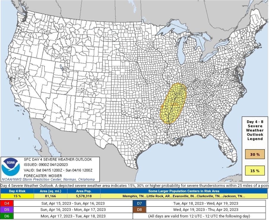
ZCZC SPCSWOD48 ALL
ACUS48 KWNS 120900
SPC AC 120900
Day 4-8 Convective Outlook
NWS Storm Prediction Center Norman OK
0400 AM CDT Wed Apr 12 2023
Valid 151200Z - 201200Z
...DISCUSSION...
A extensive cold front is forecast to stretch from northwest WI
southwestward into the TX Hill Country early D4/Saturday.
Medium-range guidance suggests mid 50s dewpoints will extend into
southern WI ahead of this front, with low 60s dewpoints reaching
into southern IL and mid 60s dewpoints reaching the Mid-South. Steep
mid-level lapse rates (i.e. about 7 deg C per km from 700 to 500 mb)
will likely cover much of the Mid MS Valley and Mid-South. These
lapse rates coupled with mid-60s dewpoints will result in moderate
to strong buoyancy ahead of the front. Vertical shear is not
expected to be overly strong, but should still support severe
storms. Discrete severe storms ahead of the main cold front appear
possible, with additional storms likely along the front itself. The
best overlap of forcing, shear, and buoyancy is anticipated from the
Mid-South into the Lower OH Valley, where a 15% outlook area was
delineated.
Thunderstorms are possible over the Upper OH Valley and Mid-Atlantic
along this front on D5/Sunday as it continues eastward. Low 60s
dewpoints may reach as far north as southern PA ahead of the front.
A negatively tilted shortwave trough may be moving into the northern
Mid-Atlantic as this time as well. Even with these favorable
dynamics and moderate low-level moisture, instability is still in
question given the poor lapse rates and likely limited heating.
These factors limit the predictability at this forecast range.
Given the moisture scouring from the previous frontal passage, the
severe potential appears low on D6/Monday. Low-level moisture may
begin returning on D7/Tuesday ahead of a low-latitude shortwave
trough, suggesting some severe potential may materialize early next
week.
..Mosier.. 04/12/2023
CLICK TO GET WUUS48 PTSD48 PRODUCT
-
Half that line formed in like 2 minutes
-
It's on Arnold's stream rn
-
Brad Arnold on the Illinois cell and had a mean looking funnel/tor for a hot second
-
 1
1
-
-
Brad Arnold got a mean looking funnel/possible tor on the Illinois cell for a hot second
-
Tornado Warning TXC035-217-030045- /O.NEW.KFWD.TO.W.0020.230402T2356Z-230403T0045Z/ BULLETIN - EAS ACTIVATION REQUESTED Tornado Warning National Weather Service Fort Worth TX 656 PM CDT Sun Apr 2 2023 The National Weather Service in Fort Worth has issued a * Tornado Warning for... Southeastern Bosque County in central Texas... Southwestern Hill County in central Texas... * Until 745 PM CDT. * At 656 PM CDT, a severe thunderstorm capable of producing a tornado was located over Meridian, or 10 miles northwest of Clifton, moving southeast at 30 mph. HAZARD...Tornado and half dollar size hail. SOURCE...Radar indicated rotation. IMPACT...Flying debris will be dangerous to those caught without shelter. Mobile homes will be damaged or destroyed. Damage to roofs, windows, and vehicles will occur. Tree damage is likely. * This dangerous storm will be near... Clifton around 715 PM CDT. Laguna Park around 730 PM CDT. Other locations impacted by this tornadic thunderstorm include Womack, Lakewood Harbor, Cayote, Morgan, Cedar Shores and Lakeside Village. PRECAUTIONARY/PREPAREDNESS ACTIONS... TAKE COVER NOW! Move to an interior room on the lowest floor of a sturdy building. Avoid windows. If you are outdoors, in a mobile home, or in a vehicle, move to the closest substantial shelter and protect yourself from flying debris. && LAT...LON 3193 9775 3204 9767 3198 9723 3179 9728 3170 9748 TIME...MOT...LOC 2356Z 301DEG 26KT 3192 9766 TORNADO...RADAR INDICATED MAX HAIL SIZE...1.25 IN $$ Dunn -
Confirmed tornado
Severe Weather Statement National Weather Service Fort Worth TX 528 PM CDT Sun Apr 2 2023 TXC293-022245- /O.CON.KFWD.TO.W.0017.000000T0000Z-230402T2245Z/ Limestone TX- 528 PM CDT Sun Apr 2 2023 ...A TORNADO WARNING REMAINS IN EFFECT UNTIL 545 PM CDT FOR SOUTH CENTRAL LIMESTONE COUNTY... At 526 PM CDT, a confirmed tornado was located 12 miles north of Bremond, or 14 miles southwest of Groesbeck, moving northeast at 35 mph. The tornado was located on Highway 14 near Kosse at 5:24 PM. HAZARD...Damaging tornado and quarter size hail. SOURCE...Weather spotters confirmed tornado. IMPACT...Flying debris will be dangerous to those caught without shelter. Mobile homes will be damaged or destroyed. Damage to roofs, windows, and vehicles will occur. Tree damage is likely. Locations impacted include... Thornton and Kosse. PRECAUTIONARY/PREPAREDNESS ACTIONS... To repeat, a tornado is on the ground. TAKE COVER NOW! If you are outdoors, in a mobile home, or in a vehicle, move to the closest substantial shelter now! Get to an interior room on the lowest floor of a sturdy building and avoid windows. && LAT...LON 3139 9671 3148 9654 3132 9639 3130 9643 3129 9665 TIME...MOT...LOC 2226Z 246DEG 30KT 3134 9665 TORNADO...OBSERVED MAX HAIL SIZE...1.00 IN $$ Barnes -
60/40 tor probs geeze
-
13 minutes ago, Powerball said:
Based on the Day 4 SPC outlook for MI/OH/IN, this thread should be expanded to 4/5.
Wild how fast threats surrounding the 4th have escalated
-
1
-
-
D1 enhanced out, primarily for hail. 5% tor expanded
-
7 minutes ago, CheeselandSkies said:
Uploaded an unlisted quick cut to my YouTube channel. Now off to bed.
Wow! Looks like something out of a dream
-
1
-
-
TOG with TDS heading into Bear Creek
Severe Weather Statement National Weather Service Birmingham AL 238 AM CDT Sat Apr 1 2023 ALC093-010800- /O.CON.KBMX.TO.W.0039.000000T0000Z-230401T0800Z/ Marion AL- 238 AM CDT Sat Apr 1 2023 ...A TORNADO WARNING REMAINS IN EFFECT UNTIL 300 AM CDT FOR NORTHEASTERN MARION COUNTY... At 238 AM CDT, a confirmed tornado was located near Hackleburg, or 7 miles west of Haleyville, moving east at 45 mph. HAZARD...Damaging tornado. SOURCE...Radar confirmed tornado. IMPACT...Flying debris will be dangerous to those caught without shelter. Mobile homes will be damaged or destroyed. Damage to roofs, windows, and vehicles will occur. Tree damage is likely. Locations impacted include... Hackleburg, Bear Creek, Tessner and Upper Bear Creek Reservoir. PRECAUTIONARY/PREPAREDNESS ACTIONS... To repeat, a tornado is on the ground. TAKE COVER NOW! Move to a basement or an interior room on the lowest floor of a sturdy building. Avoid windows. If you are outdoors, in a mobile home, or in a vehicle, move to the closest substantial shelter and protect yourself from flying debris. && LAT...LON 3420 8764 3421 8785 3428 8785 3431 8764 TIME...MOT...LOC 0738Z 267DEG 40KT 3424 8775 TORNADO...OBSERVED MAX HAIL SIZE...<.75 IN $$ 40/Sizemore -
TDS just southwest of ICC Tupelo
-
5 minutes ago, Calderon said:
Touchdown is imminent near Eagleville, TN.
Edit: Huge CC drop just north of Unionville as of 128am.
Unbelievable how stout that storm has been
-
Tor likely coming into Tupelo
-
4 minutes ago, yoda said:
Uh, hopefully thats not about to plow through metro Tupelo
PDS Warning including the city
Severe Weather Statement National Weather Service Memphis TN 113 AM CDT Sat Apr 1 2023 MSC081-115-010645- /O.CON.KMEG.TO.W.0064.000000T0000Z-230401T0645Z/ Pontotoc MS-Lee MS- 113 AM CDT Sat Apr 1 2023 ...A TORNADO WARNING REMAINS IN EFFECT UNTIL 145 AM CDT FOR EAST CENTRAL PONTOTOC AND CENTRAL LEE COUNTIES... At 112 AM CDT, a confirmed large and extremely dangerous tornado was located near Pontotoc, moving east at 40 mph. This is a PARTICULARLY DANGEROUS SITUATION. TAKE COVER NOW! HAZARD...Damaging tornado. SOURCE...Radar confirmed tornado. IMPACT...You are in a life-threatening situation. Flying debris may be deadly to those caught without shelter. Mobile homes will be destroyed. Considerable damage to homes, businesses, and vehicles is likely and complete destruction is possible. Locations impacted include... Tupelo, Pontotoc, Verona, Trace State Park, Tombigbee State Park, Saltillo, Plantersville, Furrs, Algoma, Nixon, Beech Springs, Skyline, Belden, Chiwapa, Mooreville, Palmetto, Eggville, Bissell, Chesterville and Unity. PRECAUTIONARY/PREPAREDNESS ACTIONS... To repeat, a large, extremely dangerous and potentially deadly tornado is on the ground. To protect your life, TAKE COVER NOW! Move to a storm shelter or an interior room on the lowest floor of a sturdy building. Avoid windows. If you are outdoors, in a mobile home, or in a vehicle, move to the closest substantial shelter and protect yourself from flying debris. && LAT...LON 3428 8902 3442 8855 3415 8855 3418 8902 TIME...MOT...LOC 0612Z 263DEG 36KT 3423 8895 TORNADO...OBSERVED TORNADO DAMAGE THREAT...CONSIDERABLE MAX HAIL SIZE...1.00 IN $$ MJ -
PDS warning for the northern MS storm Severe Weather Statement National Weather Service Memphis TN 101 AM CDT Sat Apr 1 2023 MSC081-115-010645- /O.CON.KMEG.TO.W.0064.000000T0000Z-230401T0645Z/ Pontotoc MS-Lee MS- 101 AM CDT Sat Apr 1 2023 ...A TORNADO WARNING REMAINS IN EFFECT UNTIL 145 AM CDT FOR CENTRAL PONTOTOC AND CENTRAL LEE COUNTIES... At 101 AM CDT, a confirmed large and extremely dangerous tornado was located near Randolph, or near Pontotoc, moving east at 45 mph. This is a PARTICULARLY DANGEROUS SITUATION. TAKE COVER NOW! HAZARD...Damaging tornado. SOURCE...Radar confirmed tornado. IMPACT...You are in a life-threatening situation. Flying debris may be deadly to those caught without shelter. Mobile homes will be destroyed. Considerable damage to homes, businesses, and vehicles is likely and complete destruction is possible. Locations impacted include... Tupelo, Pontotoc, Verona, Trace State Park, Tombigbee State Park, Saltillo, Plantersville, Randolph, Troy, Furrs, Sherman, Algoma, Endville, Chiwapa, Mooreville, Eggville, Pannell, Flowerdale, Rough Edge and Nixon. PRECAUTIONARY/PREPAREDNESS ACTIONS... To repeat, a large, extremely dangerous and potentially deadly tornado is on the ground. To protect your life, TAKE COVER NOW! Move to a storm shelter or an interior room on the lowest floor of a sturdy building. Avoid windows. If you are outdoors, in a mobile home, or in a vehicle, move to the closest substantial shelter and protect yourself from flying debris. && LAT...LON 3428 8918 3442 8855 3415 8855 3415 8918 TIME...MOT...LOC 0601Z 261DEG 39KT 3422 8910 TORNADO...OBSERVED TORNADO DAMAGE THREAT...CONSIDERABLE MAX HAIL SIZE...1.00 IN $$ MJ -
PDS Warning for Columbia
Severe Weather Statement National Weather Service Nashville TN 1250 AM CDT Sat Apr 1 2023 TNC119-010615- /O.CON.KOHX.TO.W.0011.000000T0000Z-230401T0615Z/ Maury TN- 1250 AM CDT Sat Apr 1 2023 ...A TORNADO WARNING REMAINS IN EFFECT UNTIL 115 AM CDT FOR CENTRAL MAURY COUNTY... At 1249 AM CDT, a confirmed large and extremely dangerous tornado was located over Mount Pleasant, or 10 miles west of Columbia, moving east at 55 mph. This is a PARTICULARLY DANGEROUS SITUATION. TAKE COVER NOW! HAZARD...Damaging tornado. SOURCE...Radar confirmed tornado. IMPACT...You are in a life-threatening situation. Flying debris may be deadly to those caught without shelter. Mobile homes will be destroyed. Considerable damage to homes, businesses, and vehicles is likely and complete destruction is possible. The tornado will be near... Columbia around 105 AM CDT. Spring Hill around 115 AM CDT. Other locations impacted by this tornadic thunderstorm include I-65 East Of Columbia. This includes Interstate 65 between mile markers 39 and 50. PRECAUTIONARY/PREPAREDNESS ACTIONS... To repeat, a large, extremely dangerous and potentially deadly tornado is on the ground. To protect your life, TAKE COVER NOW! Move to a basement or an interior room on the lowest floor of a sturdy building. Avoid windows. If you are outdoors, in a mobile home, or in a vehicle, move to the closest substantial shelter and protect yourself from flying debris. Tornadoes are extremely difficult to see and confirm at night. Do not wait to see or hear the tornado. TAKE COVER NOW! && LAT...LON 3552 8726 3564 8728 3577 8693 3576 8694 3575 8690 3557 8683 3557 8684 3555 8684 3553 8685 TIME...MOT...LOC 0549Z 252DEG 46KT 3557 8722 TORNADO...OBSERVED TORNADO DAMAGE THREAT...CONSIDERABLE MAX HAIL SIZE...1.25 IN $$ Whitehead -
PDS warning for Columbia Severe Weather Statement National Weather Service Nashville TN 1250 AM CDT Sat Apr 1 2023 TNC119-010615- /O.CON.KOHX.TO.W.0011.000000T0000Z-230401T0615Z/ Maury TN- 1250 AM CDT Sat Apr 1 2023 ...A TORNADO WARNING REMAINS IN EFFECT UNTIL 115 AM CDT FOR CENTRAL MAURY COUNTY... At 1249 AM CDT, a confirmed large and extremely dangerous tornado was located over Mount Pleasant, or 10 miles west of Columbia, moving east at 55 mph. This is a PARTICULARLY DANGEROUS SITUATION. TAKE COVER NOW! HAZARD...Damaging tornado. SOURCE...Radar confirmed tornado. IMPACT...You are in a life-threatening situation. Flying debris may be deadly to those caught without shelter. Mobile homes will be destroyed. Considerable damage to homes, businesses, and vehicles is likely and complete destruction is possible. The tornado will be near... Columbia around 105 AM CDT. Spring Hill around 115 AM CDT. Other locations impacted by this tornadic thunderstorm include I-65 East Of Columbia. This includes Interstate 65 between mile markers 39 and 50. PRECAUTIONARY/PREPAREDNESS ACTIONS... To repeat, a large, extremely dangerous and potentially deadly tornado is on the ground. To protect your life, TAKE COVER NOW! Move to a basement or an interior room on the lowest floor of a sturdy building. Avoid windows. If you are outdoors, in a mobile home, or in a vehicle, move to the closest substantial shelter and protect yourself from flying debris. Tornadoes are extremely difficult to see and confirm at night. Do not wait to see or hear the tornado. TAKE COVER NOW! && LAT...LON 3552 8726 3564 8728 3577 8693 3576 8694 3575 8690 3557 8683 3557 8684 3555 8684 3553 8685 TIME...MOT...LOC 0549Z 252DEG 46KT 3557 8722 TORNADO...OBSERVED TORNADO DAMAGE THREAT...CONSIDERABLE MAX HAIL SIZE...1.25 IN $$ Whitehead -
TDS on the Mississippi storm
-
Tornado Warning MSC057-081-117-141-145-010630- /O.NEW.KMEG.TO.W.0063.230401T0546Z-230401T0630Z/ BULLETIN - EAS ACTIVATION REQUESTED Tornado Warning National Weather Service Memphis TN 1246 AM CDT Sat Apr 1 2023 The National Weather Service in Memphis has issued a * Tornado Warning for... Southeastern Union County in northeastern Mississippi... Northwestern Itawamba County in northeastern Mississippi... Northern Lee County in northeastern Mississippi... Southwestern Tishomingo County in northeastern Mississippi... Southern Prentiss County in northeastern Mississippi... * Until 130 AM CDT. * At 1246 AM CDT, a severe thunderstorm capable of producing a tornado was located near Blair, or 10 miles east of New Albany, moving east at 50 mph. HAZARD...Tornado and quarter size hail. SOURCE...Radar indicated rotation. IMPACT...Flying debris will be dangerous to those caught without shelter. Mobile homes will be damaged or destroyed. Damage to roofs, windows, and vehicles will occur. Tree damage is likely. * Locations impacted include... Baldwyn, Saltillo, Guntown, Burton, Wheeler, Pratts Friendship, Blair, Marietta, Blue Springs, Thrasher, Jericho, Branyan, Ellistown, Kirkville, Jug Fork, Hobo Station, Chapelville, Moores Mill, Alpine and Corrona. PRECAUTIONARY/PREPAREDNESS ACTIONS... TAKE COVER NOW! Move to a storm shelter or an interior room on the lowest floor of a sturdy building. Avoid windows. If you are outdoors, in a mobile home, or in a vehicle, move to the closest substantial shelter and protect yourself from flying debris. && LAT...LON 3440 8890 3451 8893 3466 8832 3446 8827 TIME...MOT...LOC 0546Z 257DEG 43KT 3447 8883 TORNADO...RADAR INDICATED MAX HAIL SIZE...1.00 IN $$
-
Severe Weather Statement National Weather Service Nashville TN 1234 AM CDT Sat Apr 1 2023 TNC101-119-010545- /O.CON.KOHX.TO.W.0010.000000T0000Z-230401T0545Z/ Lewis TN-Maury TN- 1234 AM CDT Sat Apr 1 2023 ...A TORNADO WARNING REMAINS IN EFFECT UNTIL 1245 AM CDT FOR EASTERN LEWIS AND SOUTHWESTERN MAURY COUNTIES... At 1234 AM CDT, a confirmed large and extremely dangerous tornado was located 7 miles northwest of Summertown, or 11 miles east of Hohenwald, moving east at 55 mph. This is a PARTICULARLY DANGEROUS SITUATION. TAKE COVER NOW! HAZARD...Damaging tornado. SOURCE...Radar confirmed tornado. IMPACT...You are in a life-threatening situation. Flying debris may be deadly to those caught without shelter. Mobile homes will be destroyed. Considerable damage to homes, businesses, and vehicles is likely and complete destruction is possible. Locations impacted include... Gordonsburg and Hampshire. PRECAUTIONARY/PREPAREDNESS ACTIONS... To repeat, a large, extremely dangerous and potentially deadly tornado is on the ground. To protect your life, TAKE COVER NOW! Move to a basement or an interior room on the lowest floor of a sturdy building. Avoid windows. If you are outdoors, in a mobile home, or in a vehicle, move to the closest substantial shelter and protect yourself from flying debris. && LAT...LON 3564 8729 3556 8727 3545 8725 3545 8733 3546 8733 3545 8734 3546 8746 3559 8750 TIME...MOT...LOC 0534Z 260DEG 46KT 3553 8736 TORNADO...OBSERVED TORNADO DAMAGE THREAT...CONSIDERABLE MAX HAIL SIZE...1.25 IN $$ Whitehead -
Severe Weather Statement National Weather Service Nashville TN 1234 AM CDT Sat Apr 1 2023 TNC101-119-010545- /O.CON.KOHX.TO.W.0010.000000T0000Z-230401T0545Z/ Lewis TN-Maury TN- 1234 AM CDT Sat Apr 1 2023 ...A TORNADO WARNING REMAINS IN EFFECT UNTIL 1245 AM CDT FOR EASTERN LEWIS AND SOUTHWESTERN MAURY COUNTIES... At 1234 AM CDT, a confirmed large and extremely dangerous tornado was located 7 miles northwest of Summertown, or 11 miles east of Hohenwald, moving east at 55 mph. This is a PARTICULARLY DANGEROUS SITUATION. TAKE COVER NOW! HAZARD...Damaging tornado. SOURCE...Radar confirmed tornado. IMPACT...You are in a life-threatening situation. Flying debris may be deadly to those caught without shelter. Mobile homes will be destroyed. Considerable damage to homes, businesses, and vehicles is likely and complete destruction is possible. Locations impacted include... Gordonsburg and Hampshire. PRECAUTIONARY/PREPAREDNESS ACTIONS... To repeat, a large, extremely dangerous and potentially deadly tornado is on the ground. To protect your life, TAKE COVER NOW! Move to a basement or an interior room on the lowest floor of a sturdy building. Avoid windows. If you are outdoors, in a mobile home, or in a vehicle, move to the closest substantial shelter and protect yourself from flying debris. && LAT...LON 3564 8729 3556 8727 3545 8725 3545 8733 3546 8733 3545 8734 3546 8746 3559 8750 TIME...MOT...LOC 0534Z 260DEG 46KT 3553 8736 TORNADO...OBSERVED TORNADO DAMAGE THREAT...CONSIDERABLE MAX HAIL SIZE...1.25 IN $$ Whitehead -
Hohenwald is about to get hit by the TN monster. 3.7k peeps
Severe Weather 4-13-23
in Southeastern States
Posted
Surprised there isn't a thread about this. Day 1 enhanced with a 40/20 probs tornado watch already out