mgerb
-
Posts
335 -
Joined
-
Last visited
Content Type
Profiles
Blogs
Forums
American Weather
Media Demo
Store
Gallery
Everything posted by mgerb
-
14.6" on the season just over the river in Somerset. 5" OTG this morning, with 5.7" in total over the past 2 days. I'll be working on compiling NJ snow totals for these two separate events that we'll post here: http://climate.rutgers.edu/stateclim/?section=menu&target=wint2526snowtotals Since the 1/18 event started before most morning ob times in 1/18, it will take some effort to split out the 1/17 and 1/18 snowfalls.
-
https://www.ncei.noaa.gov/access/monitoring/rsi/nesis
-
Not as applicable to our latitude, but saw Buffalo gusted to 79 mph (though I see 75 mph, so not sure if the 79 is legit).
-
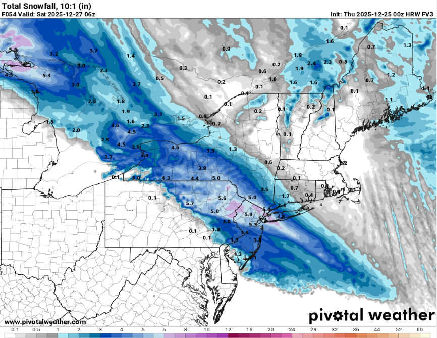
FWIW, FV3 looks good (run not complete here)
-
6.2" in Somerset (but well over 7" if measuring in grass, which is why it's important to use a board!). Might pick up a few more tenths before it tapers.
-

Moderate snowfall 12/14/2025 WWA up for most of the area
mgerb replied to WeatherGeek2025's topic in New York City Metro
Using our new Franklin station? Literally just finished installing yesterday. https://www.njweather.org/station/3678 -
Jeff Berardelli is who he meant. E.g., https://www.facebook.com/JeffBerardelli/
-
Do you report to the program?
-
There's definitely a subjective aspect to it, and one author may interpret the slew of objective data sets slightly differently than another. Aside from precip, ground water, river flow, a range of drought indices, and reports from the ground are all used to compile the product. In terms of how it's made, you might check out this short video (first below) and then a much longer and presumably much more detailed video below that (second). I think they'll be instructive in explaining how it all comes together.
-
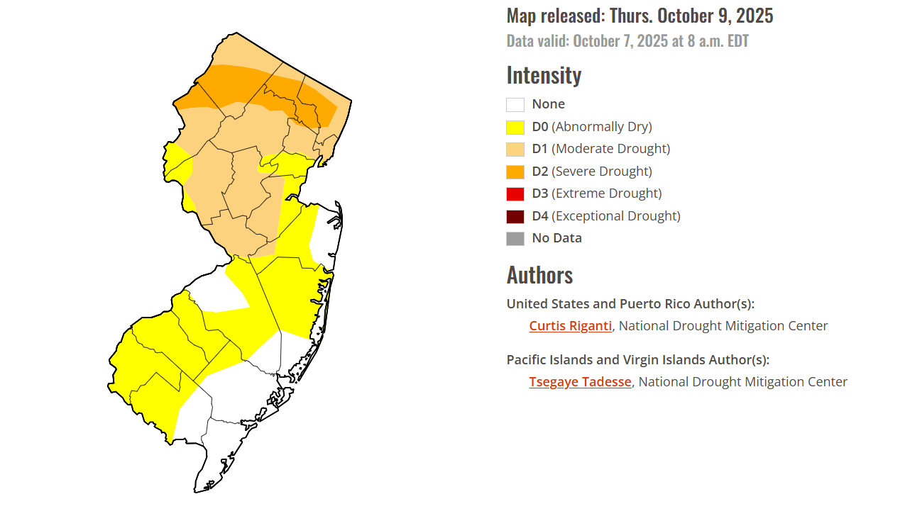
I can't reveal too much, as the final decisions lie with the national author. But from the state climate office side, we suggested mostly status quo (no change) this week, aside from removing some lingering D0 in eastern Ocean (warranted with the heavy rain from the nor'eater). They also eased up a bit in Bergen and eastern Passaic, which is fine too given the 1.50"-2.00" rainfall there, as we were on the fence about recommending improvement there or waiting. As for the areas of degradation in the western parts of the state, it's really just slight expansions of existing D0 (in Burlington) and D2 (in the far northwest), which we didn't explicitly suggest, but have no problem with given the continued dry conditions and relatively low totals from the weekend storm. Very minor changes overall. If you haven't yet, I'd recommend checking out the comparison slider, as it nicely shows the specific category changes from last week to this week. You can zoom into NJ: https://droughtmonitor.unl.edu/Maps/ComparisonSlider.aspx
-
Some of us definitely do.

-
0.41" in Somerset (0.53" including Saturday's rain). The cutoff is quite extreme, but this aspect of the event was (eventually) modeled well. Was hoping it might just push a tad further west. Better than nothing though! The drought continues.
- 731 replies
-
- 5
-

-

-
- heavy rain
- damaging wind
- (and 2 more)
-
September 2025 OBS-Discussion centered NYC subforum
mgerb replied to wdrag's topic in New York City Metro
It's also in a very low lying valley. Just perfect radiational cooling conditions there. https://www.njweather.org/station/79 -
September 2025 OBS-Discussion centered NYC subforum
mgerb replied to wdrag's topic in New York City Metro
About 0.65" in my part of Somerset (Franklin Twp). Pretty intense storm, borderline severe, with some hail mixed in. Not a ton of thunder when it get here. Lots of small branches (and a few large ones) down in my neighborhood. Township is actually requesting no unnecessary travel, so think some damage was worse in other parts of town. Definitely glad to have some good rains over the past few days (over an inch here as well). -
September 2025 OBS-Discussion centered NYC subforum
mgerb replied to wdrag's topic in New York City Metro
Looks like we'll pick up a hundredth or two here in Somerset. Not helpful. -
September 2025 OBS-Discussion centered NYC subforum
mgerb replied to wdrag's topic in New York City Metro
Can confirm that this is likely, at least on the NJ side (subject to the final call by the author). -
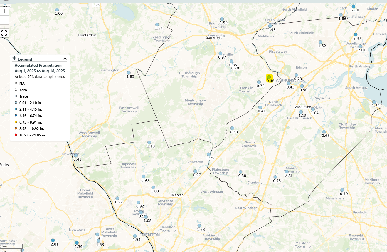
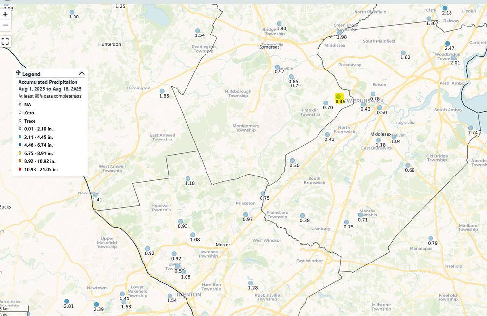
Yeah. I'm at 0.46" month-to-date (actually back to 7/27). Among the driest in the state (at least for CoCoRaHS). https://maps.cocorahs.org/?maptype=precip&units=us&base=std&cp=BluYlwRed&datetype=mtd&displayna=0&dc=0.9&key=dynamic&overlays=state,county&bbox=-76.86859130859376,39.65645604812829,-72.25433349609376,41.44066745847661
-
Say no more.
-
Very well may be. Sandy soils tend to heat up more quickly. Btw, there's a NJWxNet Mesonet station at Miller Airpark (separate from the AWOS), so you can always take a look at that too for corroboration with the KMJX reports: https://www.njweather.org/station/1032
-
It is. That's from the NJWxNet.
-
It's the flash flooding threat that's the concern.
-
Agree. Can see a (differential heating/outflow) surface boundary extending ENE from into central Somerset. I suspect storms will form/travel along the boundary. My hunch is from there south has the highest threat.
-
July 2025 Discussion-OBS - seasonable summer variability
mgerb replied to wdrag's topic in New York City Metro
Yup. Can confirm. The sensor crapped out during maintenance this morning. So it'll be down for a while while awaiting a new sensor to be prepared. Sigh. -
July 2025 Discussion-OBS - seasonable summer variability
mgerb replied to wdrag's topic in New York City Metro
For sure. If you check out the NY state FORTS inventory here, you'll find a few dozen "New York" stations, some as far back as the early 1800s. But not sure if these are indeed all NYC stations and the data quality or completeness. But if interested, definitely suggest poking around there to try to learn more. -
July 2025 Discussion-OBS - seasonable summer variability
mgerb replied to wdrag's topic in New York City Metro
No one was "sitting on this data." Rather, it was uncovered through some old-fashioned library research combined with FORTS data. Here's some more detailed background: