mgerb
-
Posts
335 -
Joined
-
Last visited
Content Type
Profiles
Blogs
Forums
American Weather
Media Demo
Store
Gallery
Everything posted by mgerb
-
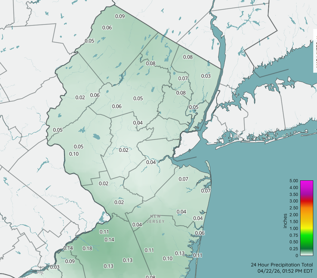
It was literally about 30 seconds here. 0.01" for the day.
-
Apparently from Pine Brook. Here's the full suite: https://www.facebook.com/share/p/1DAvYphwBS/
-
https://www.facebook.com/share/v/1LBqWnZM5i/
-
I have good news. We'll be adding a station in Sparta in the coming months!
-
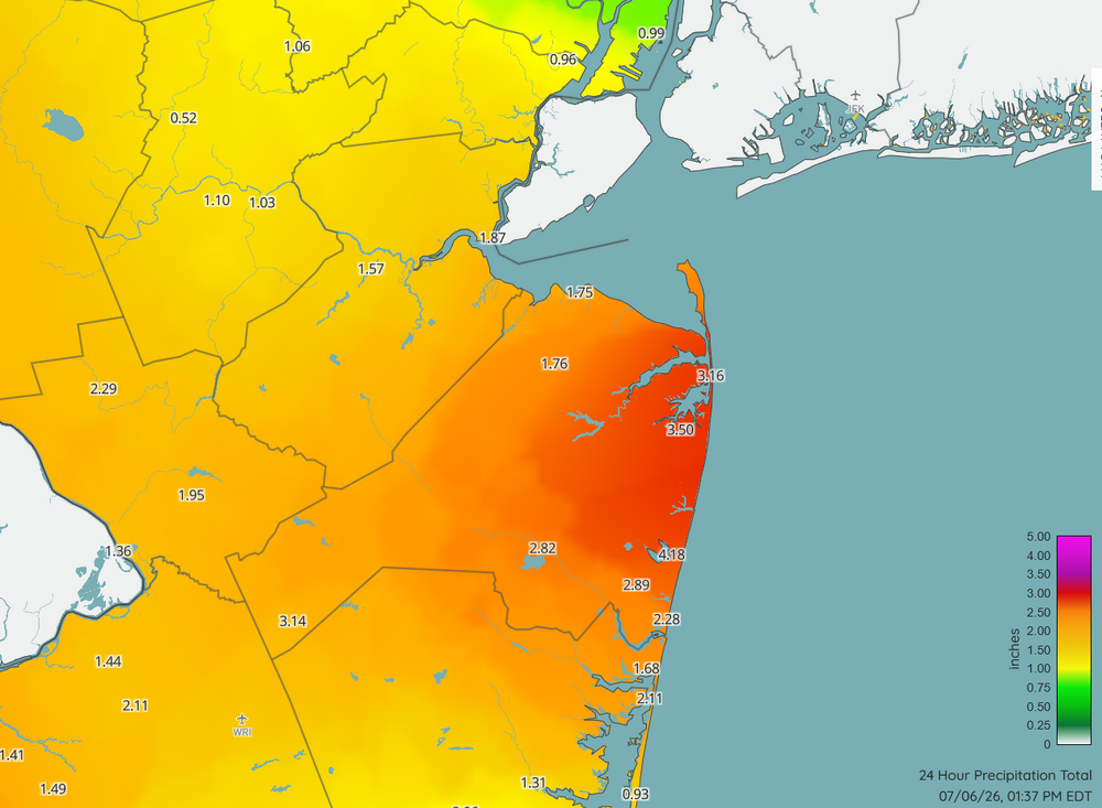
Doubt it. Radar estimates running a bit hot. 3.64" in Somerset (radar estimate 4.77"). Just relentless.
-
https://www.njweather.org/mapviewer?map=precip_24hour
-
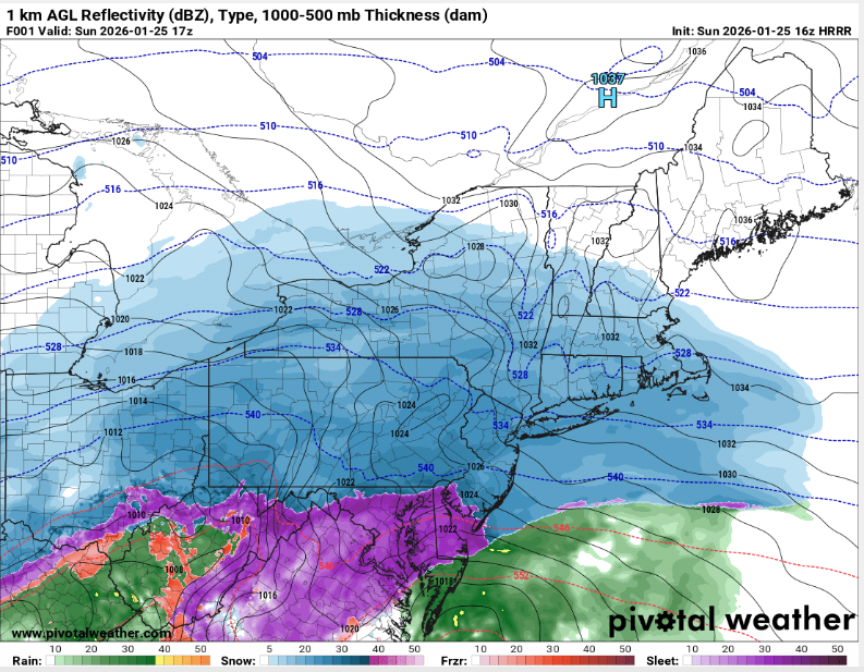
HRRR has a good handle on things


-
Yup. Lucked out with that one. Looked like the line was mostly collapsing (with occasional localized pulses), but strengthened just to my west and dropped an unexpected 0.44". Luck of the draw.

-
0.48" for the day here. A nice surprise, as was expecting a few tenths at best.
-
For NJ, I recommend this. And there's also CoCoRaHS, but most AM reports happened before all the rain had ended. https://www.njweather.org/maps/?refresh=1&map=precip_24hour

- 970 replies
-
- 4
-

-
- april showers bring may..
- rain
- (and 2 more)
-
I'd also say it depends on the time of year. Low 60 DPs in April is pretty muggy. Mid-summer, it's refreshing.
- 970 replies
-
- 3
-

-
-
- april showers bring may..
- rain
- (and 2 more)
-
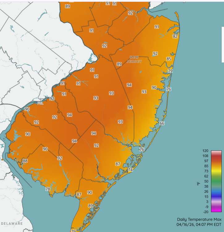
Mid-90s in interior southern NJ. Yeesh.
- 970 replies
-
- 2
-
-
- april showers bring may..
- rain
- (and 2 more)
-
@RU848789 Not yet; haven't had the chance. I'll try to chime in this weekend!
-
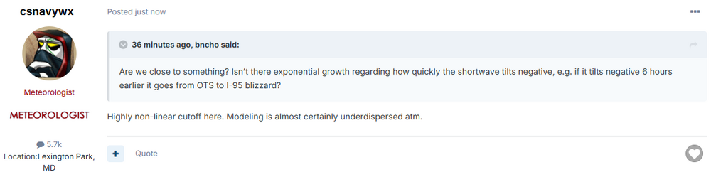
Something to consider from the MA thread, which makes sense. In other words, somewhat small changes upstream can really make a difference (in either way, of course).
-
Yup, saw that's how what you do. That's not how it's done in CoCoRaHS and COOP, so I don't really agree with this article. Rather, the maximum accumulation over the prior day of all snow/sleet is what is reported each day. That said, passing this along to some "snow experts" to see if they've ever heard of this practice.
-
I also don't clear the board except for ob time. If I cleared the board at transition, would obviously have more, but that's not really kosher (at least for CoCoRaHS).
-
I had 7.6" around the time of transition, and every time I went back out to measure each hour, it remained at 7.6". So there was enough compaction to counter any sleet accum. Haven't been out since 4 PM though, so will check again at 7:00. Hopefully have resumed a bit of accumulation since then, rather than only making the existing back denser (but not deeper).
-
Snow/sleet mix now. But still plenty of flakes.
-
When I checked at 12, I had 0.64" (based on weight). Definitely a tough event to get an accurate SWE.
-
Kickass. Keep it coming. Can't believe it's still 11 deg (edit: now 12 deg).
-
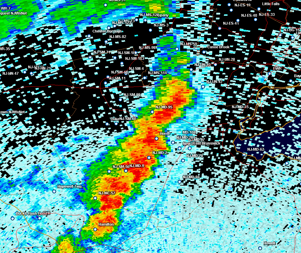
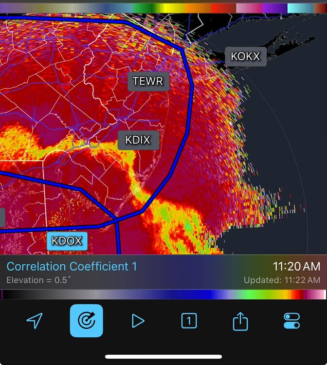
What's your mix? Some snow, some sleet? Oddly, there's little signal on KDIX base reflectivity (or the other tilts), but KDOX shows it well.
-
FWIW, HRRR hr 1 (12 PM) is too far south with the sleet line, as it appears to be approaching southern Mercer/Middlesex in NJ (based on CC and mPING). Around 7" so far here, so might be able to pull off low-end double digits with sleet included. But also suspect there will be some compaction with the sleet on top.
-
Snow/sleet line is further north than this indicates. KDOX shows it well.
-
OK, yeah. That was pretty unequivocal
-
He's a met. Also, someone claimed he said that. Should probably get a quote about exactly what he did or didn't say. It might not have been so cut and dry (or maybe it was!).