

ShawnEastTN
-
Posts
1,722 -
Joined
-
Last visited
Content Type
Profiles
Blogs
Forums
American Weather
Media Demo
Store
Gallery
Posts posted by ShawnEastTN
-
-
I'm noticing that even when I'm in an Gap in returns I still have light rain falling.Huntsville radar looking like it may be blossoming
Sent from my SM-G965U using Tapatalk
-
 1
1
-
-
Think this area has sleet/semi-melted sleet based on what I am experiencing.

Sent from my SM-G965U using Tapatalk-
1
-
-
Still 47 with rain the back edge keeps redevolping over me, though I notice a difference in the rain from an hour ago and now. Now the rain seems weighted heavier as in sleet that melted or mostly melted in the lower levels think the cold is deepening above me now (Ten Mile, Roane/Meigs county line)
Sent from my SM-G965U using Tapatalk
-
1
-
-
Light rain still on very back edge of precip Meigs/Roane county line 47, barometer still falling winds still SSE.
Sent from my SM-G965U using Tapatalk -
10:45 MRX Updtate...
.DISCUSSION...Showers have increased dramatically across middle Tennessee aheadof mid level trough as intense low pressure area over the westernGreat Lakes moves into southern Canada and the associated coldfront is now moving into west Tennessee late this evening. A lineof showers and thunderstorms was moving through west Tennessee atthis time.Strong south to southeast winds from the pressure gradient fromhigher pressure over western North Carolina to the lower pressurewest of the eastern mountains was producing wind gusts alreadyabove 60 mph and winds to around 35 to 40 mph have occurred inisolated spots in the valley. Have sped up timing of the higherpops slightly with update from southwest to northeast and bumpedlows up a degree or two over southern and central valley.Temperatures are being held up in many places by the winds andlows may have already occurred over the northeast half of thearea...or will occur around sunrise when cold front moves throughwestern sections of the forecast area. Updated forecast sent. Willupdate WSW and SPS products shortly.
Hmm... "Will update WSW and SPS products shortly"
Sent from my SM-G965U using Tapatalk
-
1
-
-
I feel good about McMinn in terms of getting a white ground especially Riceville north.PLEASE!!!! Praying for this haha!
Sent from my SM-G965U using Tapatalk
-
1
-
 1
1
-
-
Seriously the Euro went from .5" to 2" imby. If night run goes that way I think we'll see product changes with the overnight shift.If it backs up anymore at 0z, MRX is gonna have a tough call to make
Sent from my SM-G965U using Tapatalk
-
Hoping faster change over, may give some credence to RGEM faster switch over.The Euro hopefully has a few more westward creeps in it. Was it faster cold or a bigger precip shield?
Sent from my SM-G965U using Tapatalk
-
That front is pretty impressive, temperature swing of 30 degrees across a relative short distance Oklahoma City to Little Rock.
Sent from my SM-G965U using Tapatalk -
I trust that aspect of the RGEM as it really dealt well with the trailing energy with the last event also. The NAM had snow out of my area while it was still snowing the RGEM nailed it.The RGEM is capturing the likely secondary snow better than the GFS/NAM/Euro. The HRRR is capturing it too. The RGEM has been consistent for two days that snow will linger. These major league Arctic airmasses are able to squeeze everything out, the snow growth zone -15c temps get low in the atmosphere and create the snow that falls that doesn't even show up on the radar because it's falling from so low in the atmosphere.
Sent from my SM-G965U using Tapatalk
-
3
-
-
I am of agreement. I think this has high potential to bust higher for central and southern valley, plateau and highland rim.I know, I know..it's the HRRR in la la land (end of it's run)..but something interesting. As the center of the trough passes by, there is an enhancement of snow over the valley. Something to watch for on the other short range modeling. With the way everything is modeled, and such a vigorous trough (evident by the numerous banding features on all short range models), while the wrap around low moisture is almost locked in, I think there is a "potential" to bust high across the valley back to middle TN on the forcing from the trough itself (wringing out all available moisture/ terrain enhancement for the plateau adding even more lift/ and the high snow ratios shown)....but could be wishful thinking too lol
Sent from my SM-G965U using Tapatalk
-
1
-
-
I guess with the front now bisecting Arkansas approaching the Mississippi River this really is going to rapidly move into nowcast obs mode. We going to continue on this thread or someone opening an obs thread?
Edit to add: speaking of which 20 degree difference between southern AR and NW AR.
Sent from my SM-G965U using Tapatalk
-
2
-
-
One of those bands would be awesome!!! 15:1 or 20:1 ratio with pouring snow... Just a dream to get one of those imby.Def a fan of the RGEM for my area. Everything else is too little too late for most of MoCo: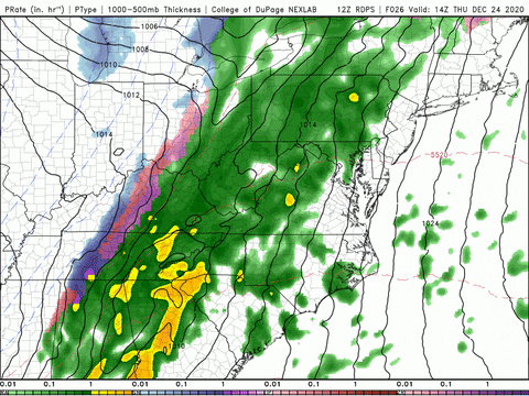
Really interested to see if something like those convective bands verify under the lapse rates of the upper low.
Sent from my SM-G965U using Tapatalk
-
3
-
-
My guess MRX will upgrade watch areas to warning, and issue advisory for plateau, and central valley, maybe advisory for Southern valley but probably SPS, mostly out of concern for slick spots from black ice and dusting.
Sent from my SM-G965U using Tapatalk-
3
-
-
Looks like Jackson KY NWS pulled the warning trigger, and also issued advisories to the west of the warning.
Sent from my SM-G965U using Tapatalk-
2
-
-
Personally I pay little attention to amounts just watch for evolution. I am very partial to RGEM for it's uncanny ability to sense energy and features that often it's closest equal the NAM doesn't sniff out.I didn't even recognize you had posted them, but that's okay, no need to apologize at all, especially to me if my post came across as provocative. I sometimes glance at them to see where the amounts over the last four runs have trended, but I never pay attention to the actual amounts, if that makes sense.
It's a cynical view of mine, but I pay little mind to the CMC and RGEM. Its cold bias is so overdone that I disregard it just about every time. It's good to show what's possible, but when does that ever pan out?
Sent from my SM-G965U using Tapatalk
-
4
-
-
Right! Also seen the inverse in recent memory, think in February same year plateau got major icing event a snow event preceded it I think in 2015 or 16 NWS started the day with knoxville forecast of .5" - 1" as the event neared they continually updated amounts all day by that night they issued a graphic of 10"-12" knoxville, Chattanooga got 10" was a huge bust in the positive.Off topic, but I remember that event. Went to bed under a WSWarning calling for 8-12 the next day. Woke up and had been upped to 12-16" and thought "here we go"........... Ended with a trace. lolSent from my SM-G965U using Tapatalk
-
3
-
-
I've always been partial to the RGEM it seemed to be in years past better at sniffing out trailing pieces of energy. I think it did a better job at sniffing out the trailing energy that made the event at the start of the month over perform for most folks.The RGEM is still snowing over the area up into Christmas morning. Actually building nicely upstream in Kentucky by 10am Christmas morning with light snow.
Sent from my SM-G965U using Tapatalk
-
3
-
-
Lol they cut accumulations from lower elevations all together in their afternoon update.Latest update from kmrx has no accumulation for Knoxvegas. Not surprising though.
Sent from my SM-G965U using Tapatalk
-
1
-
-
Peachtree City just expanded their Winter Weather Advisory to include areas outside the mountains of North Georgia all the way down to far northern Atlanta suburbs. Think they might have been caught off guard to the snow showers making that far south.
Sent from my SM-G965U using Tapatalk -
11 minutes ago, PowellVolz said:
Something that’s interesting to me is the snow is falling much harder than what the radar is indicating IMO.
.Yeah I see that all the time with snow where I live. Sometimes nothing on the radar for me from MRX, Hytop, or Nashville but snow falling.
-
2
-
-
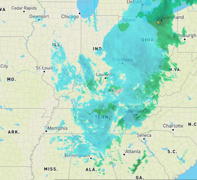
Really impressed with the amount of upstream moisture still to work through. Still good moisture all the way up in to Illinois and Indiana rotating this direction.
-
4
-
-
Agree, makes sense considering the good valley flakage here. Normally in NW flow I get very fine flakes that are pretty dried out if I get anything at all. Today I've gotten off and on fluffy flakes that just didn't feel NW flow like.I believe this is all still synoptic snow rather than NW flow snow. My precip is moving basically west to east and it looks like there's even a SW component to it at times. Looks like the NW flow snow is out west still with the streamers pointed towards Nashville.
Sent from my SM-G965U using Tapatalk
-
2
-
-
First sort of moderate snow, honestly never expected this in the valley.
Sent from my SM-G965U using Tapatalk
-
3
-

Christmas Eve/Christmas 2020 Arctic Express Snow Obs.
in Tennessee Valley
Posted
My temp starting to fall now after being stubborn at 47 for hours, down 3 degrees in the last 10 minutes. That sleet event either pulled down cold or it marks the boundary where temps begin crashing.
Edit: Wind has also switched to the N, been southerly until now.
Sent from my SM-G965U using Tapatalk