

ShawnEastTN
-
Posts
1,951 -
Joined
-
Last visited
Content Type
Profiles
Blogs
Forums
American Weather
Media Demo
Store
Gallery
Posts posted by ShawnEastTN
-
-
Heaviest I've had yet, mostly big flakes at the moment. I'm really surprised because I thought I might miss the edge of the snow almost completely. If it does this all night I'm going to bust big. I'm already passed forecast amount. Approaching warning criteria.
-
 1
1
-
-
5 minutes ago, Stovepipe said:
I did not expect huge chunky flakes with this system... but I'm over here watching quarters pile up. It's a beauty. 20.7 degrees.
Yeah I've been getting quarters mixed with smaller flakes. Then an occasional wind gust blows clouds of blowing snow off my roof and it swirls around. I'm at about 2 inches now which was the high end of my MRX forecast.
-
1
-
-
It is coming down, I've definitely crossed into heavy snow, I live on a state highway and it's now fully snow covered for the first time since it started, though its also 22 degrees which definitely helps.
-
1
-
-
6 minutes ago, John1122 said:
Looks like the band is beginning to sink into West Knoxville. Oak Ridge looks to be getting nailed currently.
That band appears to disappear as to extends to the south, but I can assume that it goes further south than the radar shows, as the snow has picked up a pretty good tick. Visibility is much lower the snow is very fine but coming down at a good clip, wind whipping it around at times makes it look even more impressive. This feels like this storm is going to really over produce. I reached about an inch total from just the frontal passage snow, and now it's picking up, heaviest it's been since it started.
-
1
-
-
19 minutes ago, WintryMixmaster said:
The last HRRR has us actually getting no snow at the moment (it's still coming down lightly at my house), and building back to our side of town around 2 AM and hanging around through 2 PM, with 3-4" on top of what we already have. Which I think would put us about on schedule for the median model result for our area
Yeah that's kind of what I anticipate is a lull until around 2-3 when snow fills back in and then hangs around. Hangs around longer the further east you are. For most all of this is really bonus snow.
-
1
-
-
For me snow has increased a bit from flurries back to the lighter end of light snow.

Sent from my Pixel 10 Pro XL using Tapatalk-
7
-
-
5 minutes ago, bearman said:
We are just getting almost nothing in West Knox even though I am in the 4 to 5 inch area. It is hard to bet against Carver, I just don't think we are going to get a lot of help from the east low. Could be wrong, but it's not looking good on Radar People like John can score on these events, but I think this is mostly going to be an extream cold wringing out moisture event.
The ULL snows haven't begun yet, this was just bonus snow from the frontal passage. I expect several hour lull, with just flurries.
-
4
-
 1
1
-
-
1 minute ago, John1122 said:
This was always going to be a slow burn for everyone. It's snowed for almost 6 hours here to get 2.5 inches and I'm over performing what I expected. It's going to be a duration event more than a huge burst event. Further east may get the burst. But for most it's more that it's going to be really cold and average probably 1/4th to 1/2 inch an hour for 10 to 16 more hours.
Yep and I love heavy snow, but I'm also never opposed to a long duration lighter snowfall either.
-
3
-
-
2 minutes ago, John1122 said:
I guess it's NW flow with the Arctic air but it's still rolling quarters and nickels here. Down to 21.6 degrees. It's extremely fluffy, a normal snowball sized handful gets you about a ping pong ball sized one.
I've somewhat overperformed the half inch forecast now.

Dang I thought it over performed with my nearly half inch!
-
1
-
-
Also this Arctic front has all on its own over performed from what most models seemed to show. I expect we'll have a bit of a lull with maybe just flurries after this initial fropa before the actual ULL snows start up.
-
2
-
1
-
-
Got a nice dusting now, very wind blown snow. If get any appreciable snow I could see there being drifts.
-
2
-
-
Seeing my first flurries on the Roane/Meigs line, air still very dry but it's starting to overcome.
-
3
-
-
Seeing my first flurries near the Roane/Meigs line.
-
1 minute ago, Hurricaneguy said:

sorry had to lol
Yeah thought about that only after I posted it.
-
1
-
 1
1
-
-
1 minute ago, Reb said:
I'd take my ~4" and call it a day
-
2
-
-
Just now, TellicoWx said:
London and Monroe added to WSW
Ahh didn't catch that!
-
MRX just added Meigs, Rhea and Bledsoe to the advisory, and OHX just added several plateau counties all the way back to Putnam county.
-
3
-
-
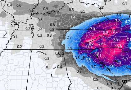
I think it was 2014 or 2015, but there was a storm very similar to this one that happened in February followed by an ice storm like 4 days later (central valley). I remember the storm really well because MRX forecast 1-2" south of 40 and east of the plateau, and forecast 2-4" north of 40, and mountains 6". This was their forecast 24 hours before. The next day they bumped everyone by an inch or so, then the storm began. It kept snowing and snowing high ratio snows they kept increasing the forecast through the evening even bumping folks in advisory up to warning. After all was said and done Chattanooga north across the whole great valley and western plateau got around 10". It was a near carbon copy storm track and type. These storms have high potential to bust high.
-
2
-
-
7 minutes ago, Reb said:
This was my cartoons growing up
Me too, I loved watching the weather channel as a kid, my family always thought that it was strange.
-
3
-
-
27 minutes ago, Holston_River_Rambler said:
Here's a throwback for y'all:

That's awesome very nostalgic.
-
2
-
-
3 minutes ago, Save the itchy algae! said:
When I lived in Charlotte these were the types of storms that modeled for the CLT area then ultimately verified NW towards either side of the apps. I think the last one was 2014 or 2015.
Yes!!!! Back way back (im old) these type storms used to almost destroy the SouthEast AccuWeather forum. People on either side rooting for it to trend there way and having complete mental breakdowns when it trended west or east and they got the shaft. Though it seemed more times than not they tended to trend NW each day a little bit all the way up to the storm breaking a lot of especially south Carolina hearts but making a lot of East Tennesseeans happy. Those were the good old days before American WX.
-
2
-
-
10 minutes ago, John1122 said:
Dramatically stronger from the Euro. Apparently it just exists to do the opposite of the GFS.
This looks reasonable to this type of setup, with very clean lines on the synoptic snow, that outside the highest peaks no real terrain favor, nice mostly clean lines north to south.
-
2
-
-
8 minutes ago, Vol4Life said:
The models have been showing a pretty abrupt cutoff. For example, Knox County is being shown on multiple models as a 4+ inch difference from east Knox to west Knox.
Yeah some have shown that while others show a weird abrupt line in the valley but then show plateau with accumulations, which from most experiences with this type of setup doesn't usually happen that way, it's usually a near perfect line north to south or NE to SW somewhere in East or middle Tennessee from the state's northern border to southern border where everyone East of that near Perfect line regardless of elevation gets snow and west of regardless of elevation get nothing. A true have and have nots scenario that elevation does not generally influence.
-
One thing I will add to this conversation is that from years of these storm types and tracks the the line between the haves and have nots is usually very abrupt. I've seen where I am located which is just about 8 miles from the Eastern Escarpment of the plateau get several inches of snow and it snow for hours but 8 miles away on the plateau itself dusting or nothing at all. Track really matters and the line will likely be much more sharp than many model output snow maps show.
-
4
-
Jan 30th-February 1st 2026 Arctic Blast/ULL Snow OBS Thread.
in Tennessee Valley
Posted
Yeah it's awesome to see blowing snow don't see it often here at all. I ended about 3.5" well I say ended but it is still snowing lightly.