

ShawnEastTN
-
Posts
1,722 -
Joined
-
Last visited
Content Type
Profiles
Blogs
Forums
American Weather
Media Demo
Store
Gallery
Posts posted by ShawnEastTN
-
-
I think you are right. Something is different, I generally don't use MRX radar for snow from the Southwest, and generally flip over Hytop. Radar scope defaults to MRX though when launching the app and I can see snow returns southwest of me from the Morristown radar. Usually Morristown doesn't even really show stuff over me. That's awesome, whatever they did.Not sure if MRX turned the sensitivity up on the radar or what but picking up returns on the plateau is very encouraging.
.-
 3
3
-
-
Got a good dusting going now. Temp down to 30.2
-
4
-
-
First flakes! It's made it to the eastern valley, Northern Meigs County. I guess shouldn't be as afraid of dry air as I was. They are tiny puny dry flakes but flakes none the less. Temp is 35, dewpoint 18.
-
3
-
 1
1
-
-
You in Rhea County correct? If so it's absolutely past you, I'm in Meigs and it's already passed me.Wondering if the artic front is making a move, temp has dropped another 2 degrees here -
Northern Meigs County in the valley my weather station showing the CAA is inbound. Dewpoint falling super fast and temps are falling as well but slower. So appears things are moving as they should at least for here and upstream of Knoxville. Generally what happens here in my neck of the woods is what is coming for West Knox in these setups.

-
3
-
-
Yes 2015 was the similar event I was waxing poetic about early in the day that way over performed.Chattanooga is going neurotic which is understandable. We suffer severe snow choke trauma.
High-res models refuse to drop the front like the Globals. Could be initialization. KCHA was 45 at 18Z. Dew of upper 20s cuts it close on the wet-bulb. I think what's happening is the usual daytime front (reinforcing shot) CAA struggles to overcome downslope off Plateau. Chatty just needs the cold air to settle in tonight despite clouds.
I believe it was Feb 2015 when a lovely isentropic setup came in from Alabama. It over-achieved. IIRC 2014 was a bowling ball. 2020 definitely was a bowling ball - more like a quidditch ball. The last cold air in place for KCHA was 2015.
So, Chattanooga will either return to glory or choke on our tears.
Rapid Refresh F-bomb Sh-curse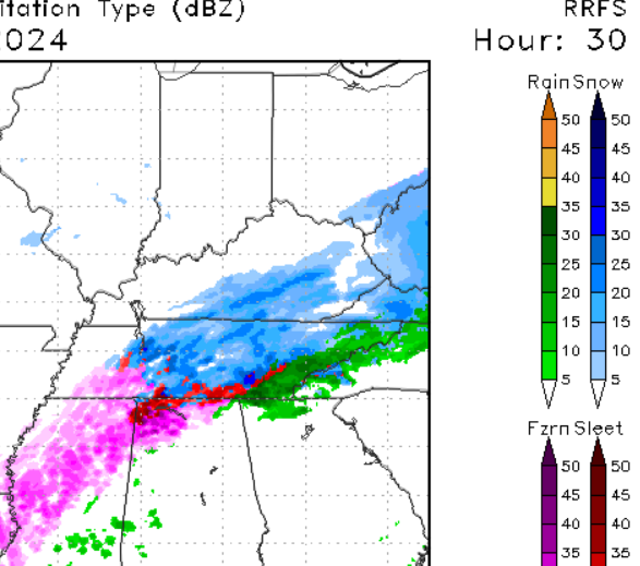
-
2
-
-
Was just getting ready to post that. I like following OHX graphics as they show my area generally in the graphic. Gives me an idea what their thoughts are for western areas of the MRX CWA.Nashville NWS looks like they are riding the NBM. That has continued to tick up with a lollipop over the Central Valley.
.
-
1
-
-
Little backing up against Frozen Head can't hurt at all. I'm a touch worried about dryness taking a while to overcome being about 8 miles from the foot of the eastern escarpment.This is my first system here where I am almost directly up wind of Frozen Head and Cross mt. I'm wondering how it plays out if that lift sets up just right -
I think there are good odds of over performing in your area.It sure wouldn't hurt my feelings if we overperformed! Lol. -
Probably if it begins over producing they will. Very possible those border counties in KY might over perform.I am just curious if NWS Jackson will upgrade some of the TN/VA border counties to a Warning.-
1
-
1
-
-
I don't know if I remember the year accurately but in the 2010's we had a similar overrunning event like this initially MRX forecast 2-5" for central valley and 1-2 southern valley, 3-6 for plateau, northeast & mountains. As the event unfolded it way way over performed in ratios and energy including a lee low. As the night dragged on they kept updating the totals until most everyone was forecast 10"-12" even southern valley. I ended that storm at 10". There are definitely times we score well beyond initial forecast in these setups. Though for every over score we probably have 2 busts.
-
2
-
-
Speaking of OBS, are we going to use this thread for OBS as well or new thread?
-
1
-
-
Yeah I think a lot of bias is playing into the ratio forecasting much like mixing is. I think the depth and strength of the cold isn't really being modeled well by most and that ratios will be higher likely than most models are showing.It looks like it in counties that touch 40 in East Tn and points south. The globals are the best case scenario, giving 12/13:1 over those areas but it lowers into the 10:1 range as the day wears on. The Canadian/GFS look similar. The hi-res models seem to see more warmth but it may be a bias with them. At one point on the NAM your area has 11:1 ratios and McGhee-Tys is closer to 7:1.-
4
-
1
-
-
Could be. Remembering back across a lot of storms that were in similar type situations it seemed MRX started sort of under the higher guidance and then just bumped totals as the event was underway. Similar to WVLT over the last 24 hours. Yesterday saying 1-2, then 2-3, now saying 2-5. Before long they'll be 4-6 or more.Anyone else thinking 3-6” in and around Knoxville could be a little light?
.-
1
-
-
MRX mentions some light snow and flurries possible with the front along the border counties tonight and SW VA in their update disco. That is technically our Arctic front that's going to lead to the fun later.
-
1
-
-
Agree, it's either going to fall in line or every other model will cave to it and it'll score a huge huge coup. I still view it as an outsider especially since it moved in the direction of a most other guidance tonight unless we start seeing other move towards the NAM at 0Z, then I might start worrying.The NAM's tendency to over amp things may be contributing to the valley p-type issues. Arctic air push is also frequently under modeled. It's dense. It should spill right in. It could be right, but I'm not as worried since it is on an island right now.
-
Yeah hard to imagine for me as well. Hopefully it comes fully around at 6Z, 0Z was a huge step in the right direction.The NAM is still managing to rain in central/southern east TN. I just have a hard time believing that could be accurate based on everything else we've seen.-
1
-
-
5 minutes ago, Tucker1027 said:
Why would they pull Hamilton County out?
.I didn't say they would or should, but I bet they have extensively talked about Hamilton county. The probability outputs they have released a lot of Hamilton County at least southern 2/3 fall below 50% threshold for 3" or more. However northern Hamilton County has tended to fall about 50% and up for 3". Safe thing would be to leave Hamilton in the WSW, but an argument based on guidance can be made for either a WInter Weather Advisory, or Winter Storm Warning. Bradley, Polk and SW NC there is no real argument Advisory based on what MRX is sharing makes sense.
-
1
-
-
1 minute ago, fountainguy97 said:
Nam cut the distance in half toward the other models. As a result temp profile will be better for most. Still not all the way but a big jump.
Right, I bet 6Z will complete the cave toward the majority of modeling and no longer blank most of the eastern forum.
-
2
-
-
5 minutes ago, PowellVolz said:
I’m thinking MRX might wait until tomorrow afternoon for the southern valley hazards.
.Yeah I suspect they might consider pulling Hamilton County out of the WSW, and maybe change it to Advisory and add Bradley, Polk and SW NC counties. Though there is a strong case to leave Hamilton County in the WSW since portions of the county meet the criteria for WSW. I think Overnight shift at MRX will likely pull the trigger. For western areas of the CWA may begin before dawn on Monday. My point forecast I have 40% change of snow beginning at 1AM Monday morning.
-
1
-
-
3 minutes ago, bearman said:
What are the general timeframes for issuing warnings?
Usually issued up to 24 hours in advance, not usually before 24 hours but they have some discretion.
-
If nothing crazy at 0z tonight I'll be hugging Euro as my global, and hugging the RGEM for short range. We are entering the time that RGEM is generally pretty accurate.
-
3
-
-
I really like the thickness of the accumulation area with this model. Isn't this going to replace a few other models eventually including HRRR?18z RRFS A. Has tons of BL issues in the East. The winter weather is still unfolding at this point.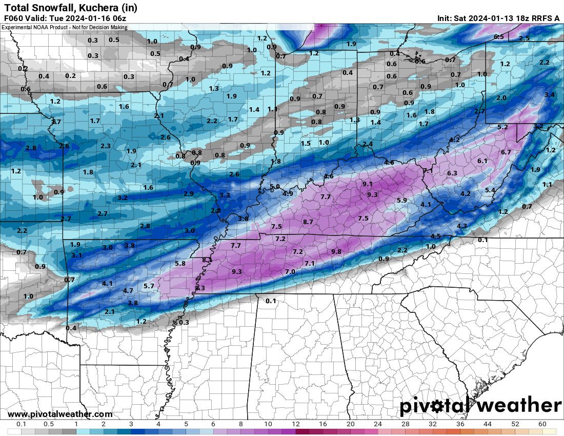
-
Interesting to see his point on the axis of heavier snow considering he was a former OHX Met, definitely puts some weight behind his opinion. Might also explain other Met decisions of not moving the axis south in their forecasts.He's a retired meteorologist from OHX so he's probably as good as anyone.
-
1
-
January 15th-17th 2024 Arctic Blast/Snow Event
in Tennessee Valley
Posted