

ShawnEastTN
-
Posts
1,722 -
Joined
-
Last visited
Content Type
Profiles
Blogs
Forums
American Weather
Media Demo
Store
Gallery
Posts posted by ShawnEastTN
-
-
Not just the lollipop, often the Chattanooga snow hole in models goes all the way to Roane county and rarely is that ever accurate. Usually in real life that snow hole is really primarily just Hamilton county but models drag it north to almost Oak Ridge often.I used to think those were erroneous lollipops, but Knox Co has to have some sort of micro-confluence there. Tellico had a great illustration overnight. On more than one occasion, Knoxville has outperformed areas to the north. I do think the front gets sheered by the time it gets to TRI as precipitation tries to get over the Apps. But that alley to the west of Knoxville seems to let a lot of precip in....I see that w/ summer thunderstorms as well. It seems if one area can dodge the Plateau rain shadow, it is Knoxville.
It is also possible that there is some smoothing from the Smokies which affects that. We often have way to much digital snow here as modeling will often smooth snow amounts too much.
Sent from my Pixel 7 using Tapatalk
-
 1
1
-
-
I don't either, usually those occur for warm nose, this setup just won't have one that pronounced I believe. 0z definitely has better looking QPF overall.24-hour ratio map. I don't believe the barren spot down toward the southern valley. But great map otherwise and up for every from 12 and 18z.
Sent from my Pixel 7 using Tapatalk
-
2
-
-
Rain snow mix at 38 IMBY.
Sent from my Pixel 7 using Tapatalk-
1
-
-
I really wouldn't be surprised if in future runs it pops a low in the Gulf that hopefully will be a good tracking storm. Fingers crossed it does.
Sent from my Pixel 7 using Tapatalk-
1
-
-
Agree, though I also think it appears to be moving through faster on 18z compared to previous runs. CAA seems to blast further south quicker.
Sent from my Pixel 7 using Tapatalk -
Makes me question the calculations between Weatherbell and Pivotal weather as they don't seem to line up.
Sent from my Pixel 7 using Tapatalk-
1
-
-
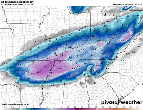
Here is kuchera Sunday before the storm.

Sent from my Pixel 7 using Tapatalk-
2
-
-
Essentially only down around Chattanooga is it around an inch. Though I don't fully understand considering it depicted snow the entire time, so must be accounting on some mixing to occur there. Chattanooga aside it's roughly the same 3-4" with some spots going 5-6".On the go right now, accumulations still in the 4”+ range for East TN on that run?
Sent from my Pixel 7 using Tapatalk
-
4
-
-
18Z GFS holds serve. Maybe a tad colder, and deeper with CAA speed. Basically full state snow, no mixing even Chattanooga rain snow line is close to Tennessee border but appears to stay south of state line.
Sent from my Pixel 7 using Tapatalk-
3
-
-
Yeah I wanted to look at the Memphis radar but appears it's under maintenance so can't get a good look out that way.Can confirm. Very light snow showers mixed in with a light rain from Memphis and into Fayette and hardeman counties east of Memphis. Wind has been screaming all day long, tough day for folks who make their living outside.
Sent from my Pixel 7 using Tapatalk
-
2
-
-
Looks like the precip modeled to build into the region this evening and tonight for snow showers is starting to show on OHX radar heading east. See some Mping reports of snow and mixed precip near Memphis currently. Maybe this will over produce like the rain QPF did with this system. I wouldn't be surprised considering the Great Lakes are wide open and the storm is interacting with the open water as that low passes through the eastern lakes.

Sent from my Pixel 7 using Tapatalk-
4
-
-
Roaring here too occasionally. It's so loud in the woods behind and around my house I can hear the roar through the trees if I have everything turned off in the house.
Sent from my Pixel 7 using Tapatalk-
1
-
-
YES well said! QPF modeled for me from this event on Euro was 1.57, I received 3.46".48 hours ago the Euro gave me .93 inches from this storm through 7pm this evening. It's raining right now and I'm at 3 inches from it.
Sent from my Pixel 7 using Tapatalk
-
3
-
-
BTW not related to the coming event but Gatlinburg is blaring warning sirens with loud speaker messages asking people to seek higher ground.
 Watch this video on Facebook
https://www.facebook.com/share/v/VD8qmva8V7ih8Q5u/?mibextid=4p3i6U
Sent from my Pixel 7 using Tapatalk-
 4
4
-
-
Absolutely! Years of marginal temps, this would be awesome. Also not a typical southern snow that is gone the next day, as modeled mostly we'd have snow on the ground for up to a week. I haven't seen that in at least a decade.What excites me most at this point are the modeled temps. For once we may not be dealing with marginals.
Sent from my Pixel 7 using Tapatalk
-
5
-
-
OHX on FB just now:

Sent from my Pixel 7 using Tapatalk-
5
-
 2
2
-
-
I am too usually from south winds as my exposure is north with a ridge generally blocking south winds. Usually in strong south winds I can hear them roaring up the ridge from my house. Though even with that protection I still tend to somehow get the odd gust that comes down the ridge. Those odd gusts have been numerous in the last hour, more than normal.Not too much up here on the plateau yet but my location doesn’t usually get much in these situations.
Sent from my Pixel 7 using Tapatalk
-
1
-
-
I was surprised by that also. I guess using their modeling of winds seemed to show an area with a lull in the center of the central valley. Might be a big bust in their forecast.Why is the rest of the valley not under an advisory? The winds are absolutely howling here! Gusting to 30+ already
Sent from my Pixel 7 using Tapatalk
-
1
-
-
I believe it the wind in the last hour has increased rapidly here. Only gusts to about 15 an hour ago but now gusting past 30.Just got a 110 mph return on radar scope velocity near Leconte. No idea how accurate it is for ground level conditions.
Sent from my Pixel 7 using Tapatalk
-
1
-
-
Yeah pretty awesome look, especially if we get snow right at the onset. IMBY it's been a really long time since I had snow that lasted even in patches longer than 3 days, and considering I live on the north side of a ridge which gives lots of protection from solar radiation that says a lot. It's been years for me, probably all the way back to the back to back events in 2014 and before that probably 2007. Basically a decade ago to find snow that lingered on the ground more than 3 days.The 18z GFS maps are crazy cold and snowy. Take some time and give them a look. You all won't see those types of maps very often.
Sent from my Pixel 7 using Tapatalk
-
1
-
-
Schools down this way have begun closing for tomorrow. Crazy I don't recall school closing when I was a kid due to forecast winds. Meigs, McMinn, and Bradley among others have all closed for tomorrow.
Sent from my Pixel 7 using Tapatalk-
5
-
 1
1
-
-
Yes! I live about 70 miles north of Chatt but that's what we got too a crazy ton of sleet with just a little snow on it at the end.I can't remember if it was the Feb storm or the big Jan 96 blizzard, but one of those storms gave us almost 6" of sleet down here. It was like a marble countertop everywhere. Absurd sledding. MRX is missing KCHA ASOS data from that winter, so I can't look up when it actually happened.
Sent from my Pixel 7 using Tapatalk
-
I think if my memory is correct down this neck of the woods I remember 96 not for being a blizzard, but I think down in my area it was freezing rain that switched to long duration sleet then eventually to snow. Think we may have only gotten a few inches of snow but it was over ice and packed sleet.
Sent from my Pixel 7 using Tapatalk-
1
-
-
Getting Graupel & sleet pellets mostly graupel at my house currently. The Mping is my location.Yeah, models seem way off for this little system. Surprised no one is talking about this or interested.
I know there are bigger potential opportunities (or busts) ahead, but I will take whatever 3 flakes I can get. lol
Sent from my Pixel 7 using Tapatalk
-
4
-
January Medium-Long Range Discussion
in Tennessee Valley
Posted
Sent from my Pixel 7 using Tapatalk