

osfan24
-
Posts
3,472 -
Joined
-
Last visited
Content Type
Profiles
Blogs
Forums
American Weather
Media Demo
Store
Gallery
Posts posted by osfan24
-
-
It seems so close to something pretty great but I am just not sure it's going to get there.
-
 1
1
-
-
7 minutes ago, Fozz said:
Does the timing with daylight really matter in mid-January?
I always thought it’s much more of a factor in late February and March.
It does, depending on rates and temperature. But it's much, much more forgiving than late February and March. If it snows decently and it's in the 20's, it will stick without a problem.
-
 2
2
-
-
10 minutes ago, jayyy said:
Wouldn’t be historic if we had them every year or even every two years. MECS / SECS are way more common than HECS+. There’s a reason it’s considered historic.
Also, a week to reload the pattern / cold doesn’t have any impact on whether or not we see a HECS between early feb - march. I get being jaded from the past few years but man, you really do always look for the negatives. No model, especially a long range ensemble or the weeklies, is going to be able to tell you whether or not we see a HECS by winters end. The same exact models could show a HECS potential tomorrow. Wouldn’t worry so much about things that are several weeks out.I am not worried about a week or so relax. I am worried about the NAO.
-
2
-
-
18 minutes ago, WxUSAF said:
83-96 was a long damn time
93 sorta counts. But yeah, that was a long stretch. But I was only 10 in 93 so…..
-
2
-
-
44 minutes ago, SomeguyfromTakomaPark said:
I’m worried less about run to run QPF fluctuation and more about the general orientation of the stripe, whatever happens will favor our area it seems and that’s a good thing. If the stripe heads to Philly and nyc that’s no bueno.
Eh, if we whiff on this and Philly and NYC get a couple inches, I won’t be losing sleep. I want a real snow.
-
47 minutes ago, CAPE said:
Might not be exactly what we were expecting, but after maybe a one week milder period, this type of pattern can get us back to normal pretty quick. As is, it looks somewhat like 2015, but there are hints of Scandi ridging retrograding.

Latest Euro weeklies depict a longwave pattern progression from that^ to this for mid Feb. Can kick? Maybe. Subjective. I don't see any indication of a shit the blinds pattern going forward. My wag is we see a -NAO episode Feb into March.

Depressing that it looks like we might go another year without a HECS. We have to be closing in on the longest gap in between HECS that we have ever had.
-
 2
2
-
 4
4
-
2
-
-
4 minutes ago, HighStakes said:
First flakes are only 48 hours away if that initial band Thursday evening materializes.
Yeah, we need some pretty big changes in the next 24 hours or so.
-
2 minutes ago, Imgoinhungry said:
Lets start the school predictions! Im going with two hour delay for most.
.Hoco is a tough call because there is already a three-hour early dismissal.
-
1
-
-
Looks like the GFS was off its rocker about ending with .2-.4 across the area midday today.
-
CMC looks nice. The thing with these runs is, if we can see the type of tweaks we saw with this last system, this could really be a nice storm. Just dig a little more. A little closer to the coast.
-
2 minutes ago, TowsonTownT said:
Which model did best with this one? Seemed a bit of a rollercoaster with the GFS sniffing it out early then losing it then finding it again.
Seemed like GFS. Mesos seemed to be a bit too bullish once the event got going. GFS had a solid 4-5.5 across the area and that seemed to have verified very well. Euro seemed too dry.
-
3
-
-
7 minutes ago, Mrs.J said:
This just happened at my husband's office. After this time last year saying you can choose your path of working. Told them that "we work better when we are together" without giving any stats, which ticked my husband off. He mainly works with people in the Austin, TX and Montreal office so literally goes in now to sit behind his computer and have meetings that he could be doing at home. He is required now to be in 3 days a week and two of them are Tuesday's and Wednesday's as those are "meeting" days. He is not going in today he decided. Said if they have a beef he can tell them he will just take a PTO day and not work at all. He is logged in now a half hour earlier than if he would have went in. Also he has a MX5 so that was not getting put on the roads today.
It's very frustrating. I get that some jobs are such that you are more productive in an office setting, but most office jobs are not that way. For me, personally, I am for more productive at home than I was in the office. I don't have people constantly stopping by to talk about nothing, we don't schedule meetings unless they are actually needed, and I'm just far happier overall which makes me more productive.
-
5
-
 2
2
-
-
10 minutes ago, wxmeddler said:
Rates weren't high enough to compensate. As far as "powder", really need to have temps in the teens for that kind of stuff.
This. It was like a light mist of snow. Also, because rates were so light, cloud cover wasn't as thick and the sun could do its thing. The March storms we've had in recent years that accumulated well had temps that were a bit colder but more importantly the rates were light to moderate, not glorified sprinkles.
-
5 minutes ago, BlizzardNole said:
That's what my fed gov office does -- we don't close any more, everyone teleworks today. Even if we had a blizzard again with several days "closed" we still work. Good tradeoff with the WFH flexibility we get
Got a touch of frz drizzle coming down now
Yeah, we are still full remote, which is amazing, but I have a feeling they are going to try to force us back a couple days a week soon for whatever nonsensical reasons they have. But yeah, the tradeoff of having to work snow days has been totally worth it given the flexibility. And we have hardly had any snow days the past however many years anyway.
-
2
-
-
26 minutes ago, WxUSAF said:
Very light snow has resumed in Columbia
Surprised you are getting flakes. Freezing rain here. I guess that's probably a wrap on the snow. Had a little more than five inches here.
-
3
-
-
Will be interesting to see what precip type that slug of moisture coming up from the southwest drops and if it continues to expand. Looks mostly like a 95 and east type deal. Was pretty surprised when I woke up and saw I didn't really pick up any additional accumulations after midnight. Seemed like the winter storm warning jinxed it lol. I thought I would tack on at least a couple of inches after midnight from just very light, steady snow if nothing else. Seems like the GFS did pretty well with this one. NAM and some of the mesos, unless we get his this morning with more accumulation, were a little too bullish.
-
1
-
-
Radar a bit more scattered in coverage than I expected right now. Hopefully, it fills in some. Thought we would see another few hours of moderate snow before it became sporadic like it looks. Also, somehow the good bands keep missing me, lol. Either fall apart or go around me. Need to figure out who put up the force field.
-
2
-
1
-
-
6 minutes ago, Ralph Wiggum said:
Sick trends
Wow, so close to something bigger. Probably just going to run out of time but this thing really made big adjustments over the past 24 hours.
-
3
-
-
11 minutes ago, Maestrobjwa said:
Ya might need to get some sleep....wrong thread

He sees the future!!
-
4
-
-
4 minutes ago, nj2va said:
Upgraded to a warning
District of Columbia-Prince Georges-Anne Arundel-
Northwest Montgomery-Central and Southeast Montgomery-
Northwest Howard-Central and Southeast Howard-Rappahannock-
Fairfax-Arlington/Falls Church/Alexandria-Northern Fauquier-
Western Loudoun-Eastern Loudoun-Northern Virginia Blue Ridge-
Northwest Prince William-
1028 PM EST Mon Jan 15 2024

...WINTER STORM WARNING IN EFFECT UNTIL 10 AM EST TUESDAY...

* WHAT...Heavy snow, possibly changing to light freezing rain or
  freezing drizzle along the Interstate 95 corridor toward
  morning. Total snow accumulation of 4 to 6 inches and ice
  accumulations of a light glaze.

* WHERE...Portions of central Maryland, The District of Columbia
  and northern Virginia.

* WHEN...Until 10 AM EST Tuesday.
Let’s gooooo!!!!!! It’s been forever! Feels amazing. And just as some tasty bands are incoming.
-
5
-
1
-
-
If RAP is right, I could hit 8 or maybe a little higher.
-
3
-
3
-
-
13 minutes ago, Maestrobjwa said:
He meant late January, lol
We wish.
-
1
-
-
11 minutes ago, Ji said:
How creepy and accurate was this lol

Weird. February might not work out that way though.
-
1
-
1
-
-
Just now, Scraff said:
Real nice showing today. Love to grab 1 more inch. Radar says maybe!?

Wow, nice total for you so far. You might be able to double that.
-
1
-

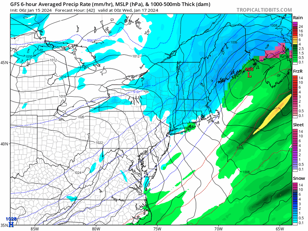
Jan 18-19 Storm Threat: Bob Chill made me do it
in Mid Atlantic
Posted
This "event" happens mostly during the day, too, so rates are going to be important or it's just gonna be wasted qpf anyway.