

osfan24
-
Posts
3,679 -
Joined
-
Last visited
Content Type
Profiles
Blogs
Forums
American Weather
Media Demo
Store
Gallery
Posts posted by osfan24
-
-
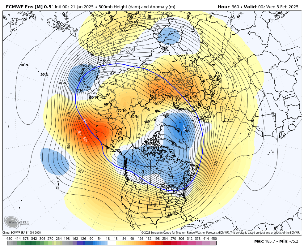
Euro from last night looked pretty interesting. Not seeing much of a warm-up through the whole run with some shots at snow.
-
 2
2
-
-
5 minutes ago, CAPE said:
This look isn't great but its workable, with a -WPO and close to neutral EPO, TPV in a good spot, and despite a +AO/NAO. Still a mechanism to deliver some cold at times. Just have to time a wave when the cold presses the gradient southward.
I really need to see at least the AO negative, if not the NAO as well, to get really interested.
-
4 minutes ago, jonjon said:
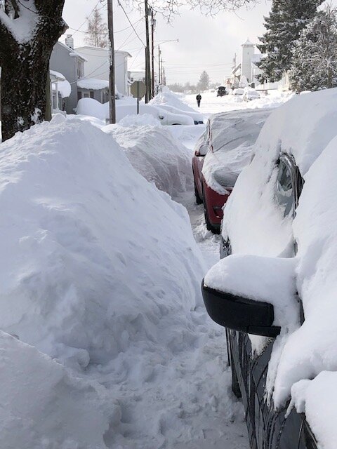
Also brutal just shoveling out the cars today. Temps just above zero and wind make it so I can only handle being out there for 15-20 minute sessions.
.jpg.c97f3eadec18fcaa47bc8c1c4a16b2d2.jpg)
Now that’s deep winter!!
-
1
-
-
40 minutes ago, WxUSAF said:
Briefly heavier snow in this squall than anything yesterday
Same. Honestly, today has been more fun than yesterday with a few squalls moving through. Last squall was arguably the heaviest snow I’ve seen this year. Have close to as much snow from today as yesterday.
-
Just give us our long-awaited HECS and we can all relax and just enjoy whatever else winter has in store for us.
-
3
-
-
What a garbage weekend all around. Mark Andrews can walk home from Buffalo in the snow.
-
1
-
 1
1
-
-
33 minutes ago, WxUSAF said:
Just measured the same. lol. What a pile of shit.
So bad. Hard to complain about this winter so far, but unless we get hit with one of these storms this week, I’ll go into late January right around climo to this point. This “event” was awful. Our only good storm was kinda underwhelming in some aspects. The heaviest snow fell in the wee hours of the morning and it only totaled like 6-7ish inches between parts 1 and 2. Kinda disappointing given the hype and the talk about it being such a loaded pattern. Hopefully, we get slammed at some point.
-
1
-
-
4 minutes ago, Eskimo Joe said:
Per SPC mesoanalysis the coastal has formed and there's a decent 925-850 frontogenesis area forming up just east of I-95.
You can see that happening on radar. It’s pretty much over for those near and west of 95. You can see all the bands to the west falling apart and things east of 95 blossoming. What a terrible event for some of us. Happy some of you made out well enough.
-
3 minutes ago, Eskimo Joe said:
It's nice. If we were two or three degrees colder regionwide this morning a lot more people would've won.
Maybe, but honestly, there wasn’t much precip until 2 or so in the afternoon for a lot of people. I’ll be interested to see a qpf chart when this one is over. Yeah, the lack of cold didn’t help, but all the precip seemed to end up from about Mt. PSU and Northwest from there.
-
21 minutes ago, WxUSAF said:
Think 2” still could happen for parts of the immediate metro area…maybe?
I don’t know. I just can’t get a band and when I do, it lasts for 5 minutes. I’d love to know where this snow is that people say is coming down 2 inches an hour.
-
1
-
-
Just can’t get decent rates for any period of time. Back to very light snow.
-
Coming down well now. It’s actually a mix of snow and sleet and snow pellets. But all surfaces have caved quickly. Actually pretty impressed with how quickly the street caved.
-
1
-
-
Just now, WxUSAF said:
Mulch and dirt is caving to my sleet rates

Snowing lightly here.
-
7 minutes ago, WxUSAF said:
I said 3-5” for MBY and 2-4” for DC. I think the bottom of those ranges may still be just reachable. But we need ~4 hours of ripping fatties probably to make that.
I think we can still manage 2-3 inches or so if it comes through and pummels for a bit. But between temps and just duration, we have some things really working against us now.
-
3 minutes ago, WxUSAF said:
Far N/W crowd might have 2-4” even before the stuff out west rotates through everyone. Unless something changes soon, might be closer to 4pm before I can sustain any precipitation IMBY.
Right. I was just looking at radar a little more loosely and you can almost see that line setting up where basically you have to be at least in extreme western Moco/Hoco and west of there to think you are going to get consistent snow for the next couple of hours at least. I think we are just a bit too far southeast. We will probably get an inch or two later when it swings through.
-
Up to moderate snow now. Flake size picking up. We’ve got a car-topper lol. (Things I didn’t think I’d be saying at 1:30 today)
-
Finally something going on. A steady light snow, but a bit disappointing because I am sitting under a yellow band.
-
1
-
-
3 minutes ago, WxUSAF said:
I have concerns
Radar is just way too spotty. There does look to be some nice bands setting up, but they are very spotty.
-
Of course, cold air taking too long to help us today but going to be way too much of it for that Tuesday/Wednesday storm.
Still holding out hope for the late week storm but Euro isn’t interested at all and even the overzealous CMC is wide right and has been many runs now.
After that, who knows. Too far out to even really look at.
-
Just now, jayyy said:
Rain/mix to snow with most of it falling in a 4-5 hour period when we have the best lift over the area has been the forecast all along. Nothings really changed for dc / Baltimore and points NNW at this point.
I hope you are right. Seems warmer than expected and it’s going to be harder to get accumulation and good ratio’s with temps 32-34 and snowing. Radar doesn’t look at that impressive to me yet, either, unless you are up toward PSU land.
-
A few flakes mixing in. Nervous to get going. This isn’t 12-24 hour storm. Can’t be wasting any qpf.
-
1 hour ago, Amped said:
One more thing about the Friday system is it reminds me a lot of the setup a few days after the Blizzard of 96.
https://www.meteo.psu.edu/ewall/NARR/1996/us0112.php#picture
Edit: Throw in the Februrary 2001 setup also.
Reminds me of January 2000.
-
If Ji and Jebman ever met, I think the world would explode. Most optimistic poster ever and the most pessimistic ever.
-
6
-
 3
3
-
-
Euro is annoying. Juice up, baby!
January Medium/Long Range: A snowy January ahead?
in Mid Atlantic
Posted
Shred factory.