jbenedet
-
Posts
7,617 -
Joined
-
Last visited
Content Type
Profiles
Blogs
Forums
American Weather
Media Demo
Store
Gallery
Everything posted by jbenedet
-

December 2024 - Best look to an early December pattern in many a year!
jbenedet replied to FXWX's topic in New England
Bangor Maine with a 50F this morning. That should be good for a +15.... -
December 2024 - Best look to an early December pattern in many a year!
jbenedet replied to FXWX's topic in New England
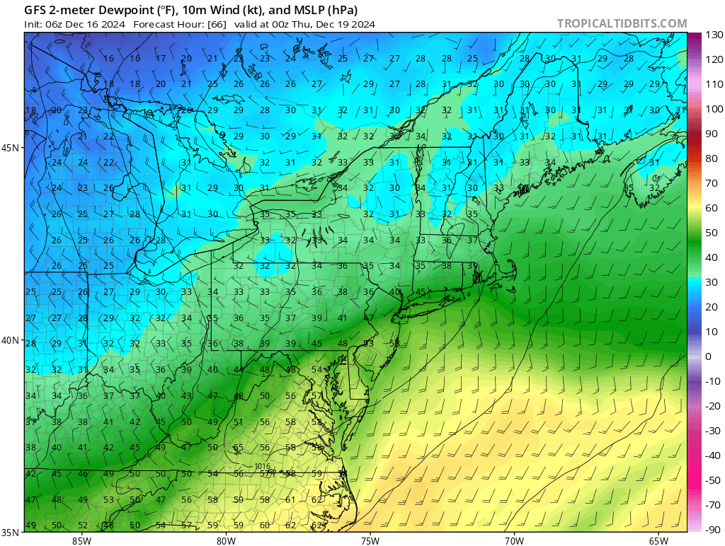
The warmth ahead is impressive, but to me the lack of cold behind these fronts is the more interesting story. Keep in mind this is *while* the pacific is cooperating... Have to go way up into UP of Michigan or far interior Ontario to even find temps at freezing... https://www.spc.noaa.gov/exper/mesoanalysis/new/viewsector.php?sector=16#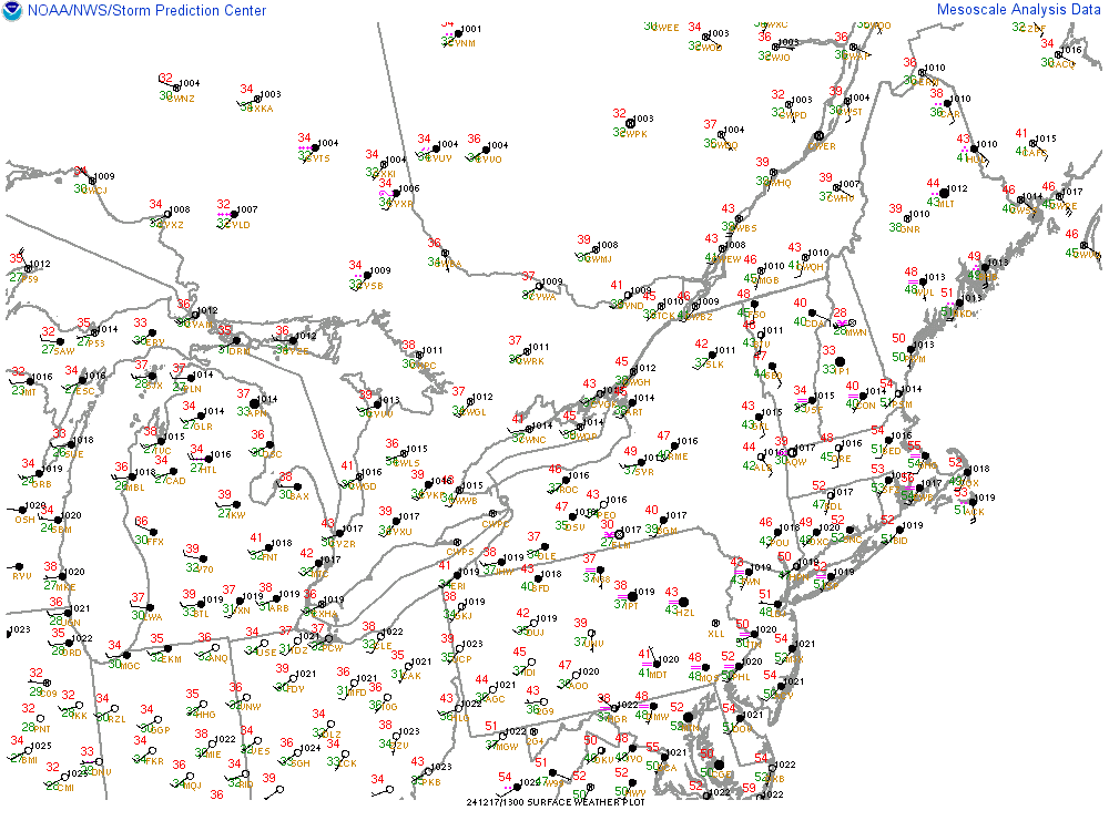
-
December 2024 - Best look to an early December pattern in many a year!
jbenedet replied to FXWX's topic in New England
At least the warm weather around Christmas makes for lighter packing when traveling... -
I dunno ....I read through some of this stuff and I find it all unnecessarily complicated. Gobbledygook.... Keeping it simple.... I see significant differences between the MJO forecast for the GEFS and EPS... GEFS wants to spend a lot of time in phase 7 at high amplitudes while EPS wants to move through 7 at low amplitude and into phase 8 by beginning of the year. For the east, this is amounts to significant difference in sensible weather outcomes given the phase 7 (+AN) /8 (BN) tendencies. The GEFS currently has a lot more company than the EPS... my bet would be accordingly.
-
December 2024 - Best look to an early December pattern in many a year!
jbenedet replied to FXWX's topic in New England
Yea. Again there's no canadian high, and the antecedent is warm. I find when you look to your north/west and see dews at/above freezing in marginal events like this, it's a pretty big tell on rain or, at best, white rain. We're basically relying on wetbulbing and wetbulbing alone won't cut it with this airmass.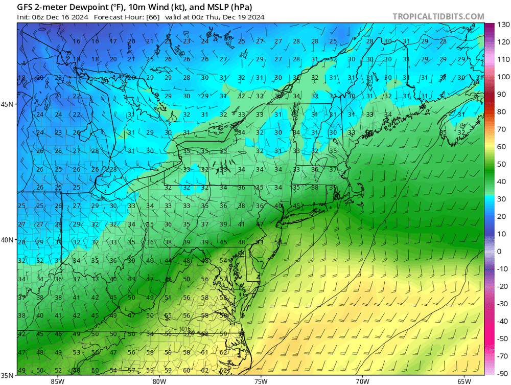
-
December 2024 - Best look to an early December pattern in many a year!
jbenedet replied to FXWX's topic in New England
I mentioned yesterday that most interesting system for eastern SNE is around the 20th. Cape scrape appeal. Yea should watch that down there. All I’m saying is the pattern is shifting to hostile starting around 22nd and last to at least end of year. -
December 2024 - Best look to an early December pattern in many a year!
jbenedet replied to FXWX's topic in New England
Tomorrow 50’s all the way to presque isle. -
December 2024 - Best look to an early December pattern in many a year!
jbenedet replied to FXWX's topic in New England
Pattern begins changing for the worse around the first day of winter. Looks like ski country will be fighting to keep what they have to end the year. -
December 2024 - Best look to an early December pattern in many a year!
jbenedet replied to FXWX's topic in New England
The 21st is the well-timed shortwave in terms of supportive cold in an overall AN pattern but the system is way south and suppressed on current GEFS and EPS guidance. IMO outside of interior NNE it’s the only one to watch with some mild interest. Cape scrape opportunity with this one…SE areas of the subforum favored here… -
December 2024 - Best look to an early December pattern in many a year!
jbenedet replied to FXWX's topic in New England
19 for the low. -
Numbers aren’t gonna get closer than that down to the day. Interestingly too, following last year’s pattern, next few weeks are tilted to warm/wet in the northeast. It is following very closely.
-
Okay guy. You got me, alright.

-
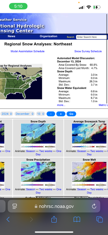
Significant El Niño conditions this time last year; low end Nina conditions this year…But…. Snow cover in the northeast US and southeast Canada is basically same as this day last year. Percentage wise and area coverage. Strikingly similar.
-
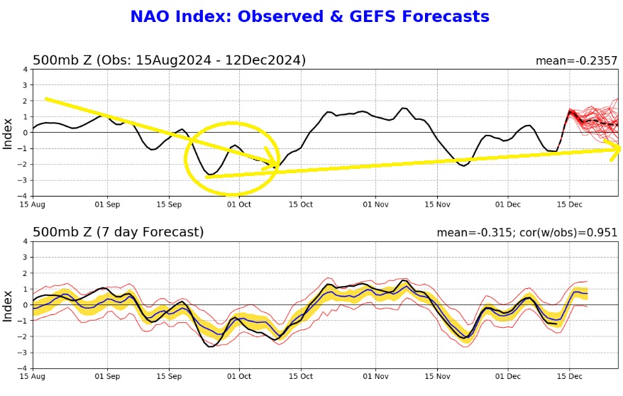
Also, I don't know if that's the right take on this. I think the better read is that -NAO was still in the background state but not felt in sensible weather until much further north. My belief is the cold influence of -NAO's has also weakened (at our latitude) with time due to the warmer SST's in eastern Canada and the Gulf of Maine. The mid level confluence response that we are so used to seeing in our region in a -NAO regime is now displaced further north/east, generally...
-
Yes but what about the seasonal pattern to this? I think it has to do with the climatalogical peak and min of SST's In the North Atlantic. For example - Iceland's temperature isn't as negatively affected by the shutting off of the AMOC in late spring and summer (atmospheric temp > water temp), but it is severely reduced in winter (water temp >> atmospheric temp)... Hence the cold pool phenomomen peaks in early winter...and the peaking of the cold pool coincides with a flip to +NAO tendency. This is the critical aspect to my hypothesis...
-
NAO Index is following very similar behavior to last year. I would like to better understand why we see -NAO tendency dominate fall, flip to +NAO tendency around the beginning of winter (end of December/mid January), and predominate through mid March... As we know from an ENSO state, this year vs last is apples to oranges and yet, the NAO index is following very closely... Something bigger may be going on here... I know on the climate change side there has been a semi-permanent "cold pool" observed to be centered in the region of iceland, which is theorized to be driven by the slowing down of the gulf stream component of the AMOC. Perhaps the development and peaking of this "cold pool" coincides with the the near solar minimum, which in turn drives the NAO Index to positive tendency. The cold pool is relatively less by mid March as SST's in the North Atlantic achieve minimum, and ISR is more influencial to +temp anoms in this part of the world...
-
https://forecast.weather.gov/data/obhistory/KBHB.html Bar Harbor— 38 sustained gust 67, last night.
-
61/59
-
Bar Harbor ME 59/57 Really gives idea on how warm the North Atlantic still is. Gonna be great spot for wind gusts too… maybe the region max…
-
DAW has been cooked for a few hours now. Not a good sign for the people trying to hold their pack. DAW is usually a rock for the CAD.
-
December 2024 - Best look to an early December pattern in many a year!
jbenedet replied to FXWX's topic in New England
Well combination rainfall+snowmelt Southern VT, in particular. I stupidly didn't look much into interior Maine. That actually looks the worst based on latest guidance. NH looks relatively spared as precip max is collocated with the areas of minimal snowpack/unfrozen ground. -
December 2024 - Best look to an early December pattern in many a year!
jbenedet replied to FXWX's topic in New England
Beats the heck out of 34 and downpours. Save on the heat, take out the dog for a walk in between showers. -
December 2024 - Best look to an early December pattern in many a year!
jbenedet replied to FXWX's topic in New England
Will be dry slot for many of us east of the CT river Looks like VT going to be worst area for flooding. That has been a recurring theme...might as well keep it going. -
December 2024 - Best look to an early December pattern in many a year!
jbenedet replied to FXWX's topic in New England
Something dystopian about this thread title. Perhaps, instead, I'll just read it as sarcasm... Over this period, I have received 2" of snow but also 2" of rain; pack is about to get wiped-out area wide up to the "north of the wall" lakes region latitude, and the beginning of December ends in less than 4 days. -
December 2024 - Best look to an early December pattern in many a year!
jbenedet replied to FXWX's topic in New England
Warmer. 37/34 currently and still raining. If I do change it’ll be another white rain event here. NAM was the only piece of guidance that was close it seems. Took until 18z for it to key into it too. Everything else way too cold/frozen.