Chris78
-
Posts
5,218 -
Joined
-
Last visited
Content Type
Profiles
Blogs
Forums
American Weather
Media Demo
Store
Gallery
Everything posted by Chris78
-
Late January and February Medium/Long Range Discussion
Chris78 replied to WinterWxLuvr's topic in Mid Atlantic
18z Gefs. After a warm up next week, definitely looks like some possibilities the second week of February.- 4,130 replies
-
- 1
-

-
- prime climo
- cold canada
- (and 1 more)
-
Hoping you and @CAPE get crushed!
-
Would like to get the front running snow a little north and not get skunked. Return on investment with this storm seems pretty low.
-
Yep. At this point I'm not expecting much at all. Will gladly take whatever we can get but the front end part of it doesn't look to be as aggressive as it was a few days ago. Hopefully it makes a comeback over the next few runs.
-
Late January and February Medium/Long Range Discussion
Chris78 replied to WinterWxLuvr's topic in Mid Atlantic
If we can be on the right side of a parade of overrunning events it's alot less nerve racking than hoping for the perfect timing and phase of multiple vorts. You won't get a big dog in this type of pattern we can certainly score light to moderate events. The biggest risk is being on the wrong side of the boundary and seeing PA North getting white while we're wet south of 40n. -
Late January and February Medium/Long Range Discussion
Chris78 replied to WinterWxLuvr's topic in Mid Atlantic
Looks like a brief warm up next week then a cool down after that. 6th and 7th keeps popping up on some of the globals. I thinking we may have more than 1 opportunity by the way the ensembles look. (Hopefully)- 4,130 replies
-
- 1
-

-
- prime climo
- cold canada
- (and 1 more)
-
What's your thoughts on the front end action Friday Afternoon/evening. Models seem to be cutting back on that. Was hoping for a few inches from that but I'm starting to be skeptical of that also.
-
Late January and February Medium/Long Range Discussion
Chris78 replied to WinterWxLuvr's topic in Mid Atlantic
Definitely. It's a little disappointing models seem to be taking away the front end stuff that us westerners needed to see anything this Friday/ Saturday. You seem to be in a pretty good spot if I have your location right. -
Late January and February Medium/Long Range Discussion
Chris78 replied to WinterWxLuvr's topic in Mid Atlantic
Gefs still advertising overrunning events coming at us from the southwest in the long range. Gefs would imply several chances coming up after a brief warm up for a few days next week.- 4,130 replies
-
- 3
-
-
- prime climo
- cold canada
- (and 1 more)
-
We got nammed. Let's hope one of the varsity models show the same.
-
Nammed?
-
Is there enough time left to make a difference up our way? I'm hoping the upper level stuff is juiced up enough to get a decent 2 to 4" event Friday evening without relying on the coastal this far west.
-
Late January and February Medium/Long Range Discussion
Chris78 replied to WinterWxLuvr's topic in Mid Atlantic
Really like the look on the gefs later on for having cold and moisture. Hoping we can get a few overrunning events for the 1st half of February.- 4,130 replies
-
- 4
-
-
- prime climo
- cold canada
- (and 1 more)
-
I agree. If I was on the Eastern shore I'd be feeling more confident. As far west as we are I'm just hoping we can maximize the front end on Friday from the upper level energy swinging through.
-
Weve seen almost every combo of angles..movement..phasing...and they all give us at best an advisory event. When is the next window? Ready for some overrunning potential the first week or 2 of February.
-
Late January and February Medium/Long Range Discussion
Chris78 replied to WinterWxLuvr's topic in Mid Atlantic
Hoping for a couple overrunning events the first couple weeks of February. Definitely think thats a better way to score for my location compared to what we have going on this weekend.- 4,130 replies
-
- 3
-
-
- prime climo
- cold canada
- (and 1 more)
-
Yes. I agree completely. Lots of lost decency. Some of the nasty unprovoked comments are unbelievable.
-
Lol. No . Not a all
-
First time ever reporting a post. I guess being behind a keyboard emboldens some people to be jerk.
-
Late January and February Medium/Long Range Discussion
Chris78 replied to WinterWxLuvr's topic in Mid Atlantic
Overrunning events are much less nerve racking but when the complicated big ones come together and we're certain that we are getting crushed it's such a great feeling of excitment. 2016, 2010,2003 1996 . Hard to compare to anything else. I guess that's what makes them so rare- 4,130 replies
-
- 6
-
-
- prime climo
- cold canada
- (and 1 more)
-
Late January and February Medium/Long Range Discussion
Chris78 replied to WinterWxLuvr's topic in Mid Atlantic
I might have to find some of @Bob Chillbunnies to kick if that map was reality.- 4,130 replies
-
- 1
-
-
- prime climo
- cold canada
- (and 1 more)
-
Late January and February Medium/Long Range Discussion
Chris78 replied to WinterWxLuvr's topic in Mid Atlantic
The ridge axis looked pretty darn to good to Me on the 6z eps.- 4,130 replies
-
- 3
-
-
- prime climo
- cold canada
- (and 1 more)
-
Down to 1 coming over the Catoctins this morning between Smithsburg and Thurmont.
-
Late January and February Medium/Long Range Discussion
Chris78 replied to WinterWxLuvr's topic in Mid Atlantic
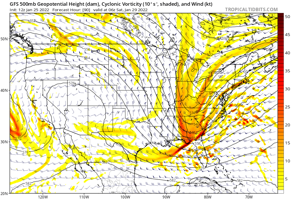
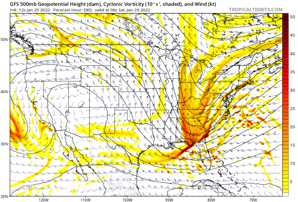
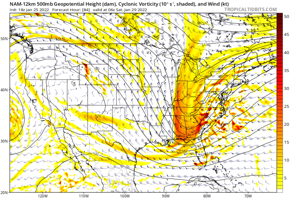
Yep. Exactly. The big take away is all 3 globals show an intense Storm along the east coast in about a week. Pretty good consensus for an amplified pattern next weekend.- 4,130 replies
-
- 1
-
-
- prime climo
- cold canada
- (and 1 more)
-
I wouldn't sleep on Tuesday. Most people seem to be focused on next weekend but Tuesday could be a sneaky event. Especially for m/d and PA.