

Fozz
-
Posts
38,078 -
Joined
-
Last visited
Content Type
Profiles
Blogs
Forums
American Weather
Media Demo
Store
Gallery
Everything posted by Fozz
-
The first HECS in February completely missed New England, as well as Manhattan. The second storm was a painful bust for SNE, and then the late month "Snowicane" brought a HECS to NYC while SNE received 40 degree wind-driven rain. I almost felt bad for SNE that winter, but at the same time I didn't... the key word is almost. People who whine when they get above average snow, just because places further south are getting more, annoy me. They think they're entitled to always get buried.
-
Nah, NYC and Boston got about 8-12" or so... but LI received HECS totals
-
I almost missed it... I was out of town from the 20th till around New Years. Had this storm happened just a few days later, I would have missed out on it completely. Is it this thread? http://www.easternuswx.com/bb/index.php?/topic/214818-thundersnow-18z-gfs-sounding-says-maybe/
-
I actually rank this above 2/6/2010.... for years I wasn't sure which storm I liked more, but now that I think about it, I choose December 2009, even though my area got more in the February storm. The anticipation before the storm was so much more thrilling, mainly because it was the first HECS in almost 7 years, while 2/6/2010 was the first HECS in 7 weeks and felt a lot like deja vu. The other reason is the shock and rarity of it happening in mid-December. Like I said in another thread, I didn't think a storm of this magnitude was possible in December. It was just unbelievable.
-
Time to bump this up http://www.washingtonpost.com/blogs/capital-weather-gang/wp/2014/12/17/looking-back-on-winter-2009-10-snowpocalypse-strikes-smashes-december-snow-records/
-
You all need to stop getting so depressed from remembering great storms
-
Time to be
-
Awesome storm. In the days leading up to it I literally couldn't believe what I was seeing, even though the upper air setup was fantastic. I didn't think a HECS in December was possible until this storm.
-
I couldn't even keep up with all the thrill and excitement......all seemed way too good to be true. Got my last final canceled and enjoyed my 19" of snow
-
I miss my hourly ventures outside up until 2 or 3 am.
-
25"
-
Damn..........I had at least 20" at this time exactly 2 years ago. Good times.
-
Actually, crappy winters are the best time to reminisce about the great storms of the past.
-
-
Definitely 1.
-
I had a Jebman moment.......lolz http://www.easternus...ost__p__4332793
-
It was right after midnight two years ago when Don S compared this to the Knickerbocker storm. It was a huge turning point for me towards getting on board (at first I was extremely skeptical). http://www.easternuswx.com/bb/index.php?/topic/215377-historic-lower-mid-atlantic-snowstorm-increasingly-likely/
-
Bump. It's time to bring back this thread. Luckily the eastern archives are back.
-
Me neither.
-
Based on that scale, I'd call it moderate.
-
http://news.yahoo.com/5-8-earthquake-virginia-felt-washington-york-city-175830266.html
-
About 7 minutes ago I felt some pretty loud rumbles and our chandelier near the entrance was swinging a bit. It lasted 30 seconds or so. I was almost ready to run outside. This was pretty scary.
-
Shut up weenie.
-
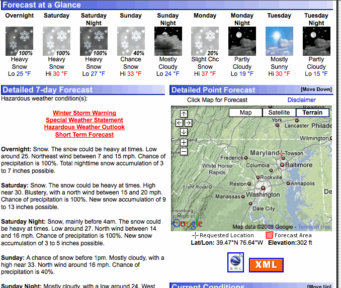
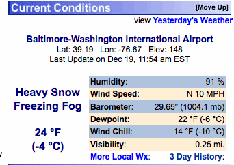
The snow was really picking up around this time.
-
What was the strongest pressure from that north Atlantic storm? I recall it being a monster.
