

ILSNOW
-
Posts
1,644 -
Joined
-
Last visited
Content Type
Profiles
Blogs
Forums
American Weather
Media Demo
Store
Gallery
Everything posted by ILSNOW
-
Top 5 snow event While the cold front will become increasingly removed the eastward moving mid-level trough and moisture, these showers are expected to survive into at least northern Illinois early to mid-evening. Several snow squall ingredients will be in place, chiefly a linear forcing mechanism with sufficient low- level instability nearing 50 J/kg in the well-mixed layer in the lowest 6kft. Brief sharp reductions in visibility (possibly near white-out) and quick accumulations of a half inch to very locally 1 inch in 30 minutes or less are possible across northern Illinois. Timing favors 6-8pm for the Rockford area and 8-10pm for most of the Chicago metro.
-
KLOT Update Through tonight... Heavy snow has expanded across much of the forecast area southeast of a line from Waukegan to Dixon, with very dangerous conditions unfolding for areas south of the Kankakee River into east-central Illinois. Meanwhile, a period of moderate to heavy snow with gusty winds will result in significant travel impacts into the Chicago metro through early evening. It is highly recommended that any unnecessary travel be delayed through at least early evening. The 850-700 hPa F-gen axis across northwest Illinois that was noted in an earlier AFD update is apparently playing a major role in shifting the heavier snow back north after guidance continued its southward trend prior to 12Z. The top-down saturation of this band likely acted as a dry-air barrier across far northern Illinois, allowing for quicker saturation and a farther northward footprint of the snow shield at the surface. A fairly expansive area of 25dBz+ reflectivity within an impressive jet entrance circulation and ahead of a sharp mid-level trough extends SW back to the Mississippi River as of 2pm CT. Given upstream trends and current snowfall rates in the CWA, snow totals were increased by roughly an inch across much of the area where headlines are in effect. This included an expansion of the winter weather advisory into De Kalb and Lee counties.
-
snowing here in Buffalo Grove visibility must be down below 10 miles
-
good call KLOT update Another area to watch is around the I-88 corridor west of and into the Chicago metro where a stacked 850-700 hPa F-gen axis is generating a narrow but moderate to heavy precip band aloft. Some 12Z CAMs latched onto this band, but the dry air feed from the north will erode this band to some extent near the ground. Will continue to monitor this axis for the potential for a quick couple inches of snow.
-
as Thundersnow has commented the RAP has been consistent
-
18z NAM easy toss as it brings areas NW of Chicago 3-5.
-
you mean ALEK is not goin to get 7 inches overnite?
-
has 0% chance of verifying around Chicago good luck further east.
-
he snow shield is now activated and will protect the northern tier of counties in IL and Wisconsin from any snow at the current time it is anticipated that the shield will be lowered on 12/1/22.
-
3z RAP which is prolly the most correct model at this point!!!! The RAP and HRRR are great for entertainment purposes
-
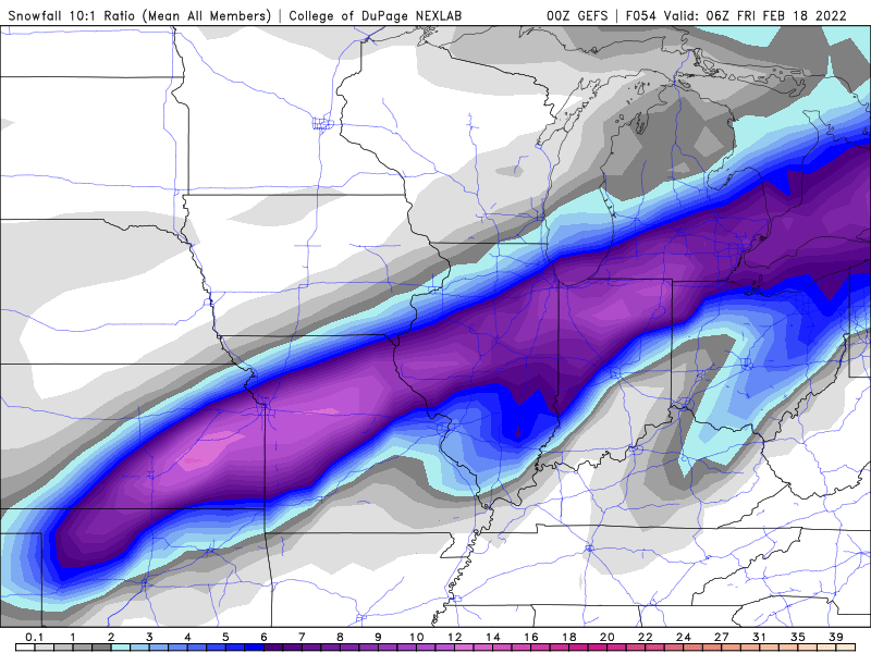
Southward bound 0z GEFS
-
-
2nd consecutive storm where RAP and HRRR are my only hope we all know how this will turnout with a solid 1-2 inches in Lake and McHenry county
-
-
18z Euro @ 24 hours
-
worst model followed by GFS and NAM!!!! And we will have a juiced run of the HRRR as well.
-
Has the RAP ever verified more than an hour out.
-
21z RAP is wet and wild and has 0% chance of verifying with 3 inch of precip in Chicago. It is smoking what the GFS and NAM were smoking.
-
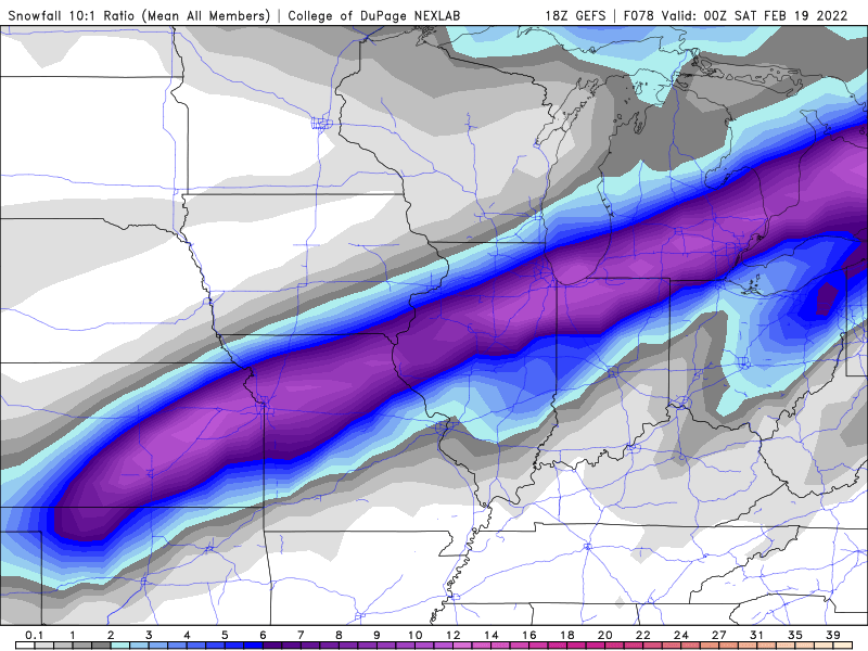
and so it begins 18z GEFS
-
almost time for the 18z GFS to give up the ghost and get inline
-
yes that and the HRRR!!!!
-
Question are these Kuchera ratio on pivotal a middle ground approach for determining snowfall or is it meaningless?
-
For the Chicago people assuming Euro doesnt budge do they put a watch out for area from Chicago north and west where the Euro is showing nothing? Tough spot to be in hope Ricky drops in.
-
-
GFS precip for downtown Chicago 0z --2.2 6z-- 2.1 12z--1.9 bigger changes for Northbrook 0z--2.3 6z--1.7 12z--1.3


